Narrow Results By
Subject
- Buildings - Civic 1
- Buildings - Civic - Libraries 4
- Buildings - Commercial 4
- Buildings - Commercial - Cinemas 1
- Buildings - Commercial - Hotels and Motels 2
- Buildings - Commercial - Malls 3
- Buildings - Commercial - Service Stations 1
- Buildings - Commercial - Stores 2
- Buildings - Recreational - Bandstands 3
- Buildings - Recreational - Stadiums 2
- Buildings - Residential - Apartments 4
- Buildings - Residential - Houses 2

Maywood Neighbourhood
https://search.heritageburnaby.ca/link/landmark801
- Repository
- Burnaby Heritage Planning
- Associated Dates
- 1955-2008
- Heritage Value
- Burnaby's Maywood Neighbourhood consists of the Metrotown Town Centre - one of four Town Centres in the City. Metrotown is one of the region's most developed and fastest growing centres. It is served by the first SkyTrain line developed in the mid-1980s and anchored by B.C.'s largest shopping and entertainment complex. As an older centre that has progressively added new developments over the years, Metrotown offers a range of housing types and tenures from three-storey walk-up apartments to modern residential towers.
- Historic Neighbourhood
- Central Park (Historic Neighbourhood)
- Planning Study Area
- Maywood Area
Images

Interview with Cice Brown, May 13, 2005 - Track 4
https://search.heritageburnaby.ca/link/museumdescription4479
- Repository
- Burnaby Village Museum
- Date
- 1930-1949 (interview content), interviewed May 10, 2005
- Collection/Fonds
- Burnaby Village Museum fonds
- Description Level
- Item
- Physical Description
- 1 sound recording (mp3) (0:06:35 min)
- Scope and Content
- Track 4: This portion of the recording pertains to friends, play, and recreation. Cice talks about Shirley, her best friend from grade school until Shirley’s death at 21. She describes the large, loose circle of friends she met in the Telford Avenue neighborhood or through school, and where they pl…
- Repository
- Burnaby Village Museum
- Collection/Fonds
- Burnaby Village Museum fonds
- Series
- Museum Oral Histories series
- Subseries
- Growing Up in Burnaby subseries
- Description Level
- Item
- Physical Description
- 1 sound recording (mp3) (0:06:35 min)
- Material Details
- Interviewer: Tom Gooden Interviewee: Cice Brown Date of Interview: May 13, 2005 Total Number of Tracks: 7 Total length of all Tracks: 0:40:19
- Scope and Content
- Track 4: This portion of the recording pertains to friends, play, and recreation. Cice talks about Shirley, her best friend from grade school until Shirley’s death at 21. She describes the large, loose circle of friends she met in the Telford Avenue neighborhood or through school, and where they played. Cice recalls how she spent time with her high school friends, and discusses the games that she played with her family and friends.
- History
- Recording of an interview with Cice Brown, interviewed by Tom Gooden on May 13 2005. This recording was completed for an exhibit, Growing Up in Burnaby, for the Burnaby Village Museum. Major themes discussed are growing up in Burnaby in the 1930s and 40s.
- Creator
- Burnaby Village Museum
- Names
- Brown, Cice Chandler
- Geographic Access
- Telford Avenue
- Accession Code
- BV017.45.3
- Access Restriction
- No restrictions
- Reproduction Restriction
- May be restricted by third party rights
- Date
- 1930-1949 (interview content), interviewed May 10, 2005
- Media Type
- Sound Recording
- Planning Study Area
- Maywood Area
Audio Tracks
Interview with Cice Brown, May 13, 2005 - Track 4, 1930-1949 (interview content), interviewed May 10, 2005
Interview with Cice Brown, May 13, 2005 - Track 4, 1930-1949 (interview content), interviewed May 10, 2005
https://search.heritageburnaby.ca/media/hpo/_Data/_BVM_Sound_Recordings/Oral_Histories/2017_0045_0003_004.mp3
Interview with Don Brown by Rod Fowler February 26, 1990 - Track 8
https://search.heritageburnaby.ca/link/oralhistory509
- Repository
- City of Burnaby Archives
- Date Range
- 1947-1990
- Length
- 00:11:47
- Summary
- This portion of the interview is about Don Brown identifying old businesses and stores on Kingsway, and talking about the operation of the interurban, the lack of cars after the war, and the two vehicles used by the Burnaby police in 1948. He talks about the expansion of Burnaby in the 1950‘s and t…
- Repository
- City of Burnaby Archives
- Summary
- This portion of the interview is about Don Brown identifying old businesses and stores on Kingsway, and talking about the operation of the interurban, the lack of cars after the war, and the two vehicles used by the Burnaby police in 1948. He talks about the expansion of Burnaby in the 1950‘s and the attempts to preserve heritage buildings and trees, historic records, and green space
- Date Range
- 1947-1990
- Photo Info
- Royal Canadian Mounted Police Sergeant Don Brown, November 2, 1997. Item no. 535-0979
- Length
- 00:11:47
- Historic Neighbourhood
- Central Park (Historic Neighbourhood)
- Planning Study Area
- Marlborough Area
- Maywood Area
- Interviewer
- Fowler, Rod
- Interview Date
- February 26, 1990
- Scope and Content
- Recording is of an interview with Don Brown, conducted by Rod Fowler. Don Brown was one of eleven participants interviewed as part of the SFU/Burnaby Centennial Committee's oral history series titled, "Voices of Burnaby". The interview is mainly about Don Brown’s description of the changes in Burnaby’s built and natural landscapes and socioeconomic conditions, especially between 1947 and 1975, the strong impression made on him by those changes evident in the interview. He talks about his work and career as a police officer with the Burnaby Provincial Police and RCMP. The interview also details his involvement in Burnaby politics and volunteer community groups. To view “Narrow By” terms for each track expand this description and see “Notes”.
- Biographical Notes
- Donald Neil “Don” Brown was born in Birmingham, England May 4, 1919, and immigrated with his parents and siblings to Winnipeg in 1922. At the outbreak of WWII Don Brown left high school and enlisted in the 12th Field Company, Royal Canadian Engineers, serving six years in the army. Before going overseas he married Helen Birch in 1939. In 1947 Don Brown joined the B.C. Provincial Police which was absorbed by the RCMP in 1950. He worked as a police officer in Burnaby from 1947 to 1954, and then was transferred to Ottawa (with a stop in Regina) for nine and a half years where he attended Carleton University to study forensics. In 1963 Don Brown was transferred back to Vancouver and bought and moved into a house on Watling Street in Burnaby where he still lived in 1990. Another transfer took him to Edmonton for five years, returning to Burnaby in 1975. Following retirement in 1980 with the rank of Supervisor and after 22 years in forensic laboratories, Don Brown started his own business as a private document examiner. Don Brown was active in Burnaby politics, serving as Alderman from 1979-1985. He was also involved in many community groups including the South Burnaby Men’s Club, which he helped found in 1952, as well as active in the Burnaby Historical Society, and served on the Burnaby School Board, Burnaby Centennial Committee, and the Community College for the Retired. Don and Helen Brown had six children: Donna, Don, Gina, Patricia, Christopher and Susan. Don Brown died May 16, 2009.
- Total Tracks
- 14
- Total Length
- 01:35:07
- Interviewee Name
- Brown, Donald N. "Don"
- Interviewer Bio
- Rod Fowler returned to university as a mature student in the 1980s after working about twenty years in the field of economics and computerization in business in England, Europe and Western Canada. He graduated with a BA from SFU in both History and Sociology in 1987, his MA degree in Geography in 1989, and his PhD in Cultural Geography at SFU. He taught courses in Geography, Sociology, History and Canadian Studies at several Lower Mainland colleges, before becoming a full time member of the Geography Department at Kwantlen University College.
- Collection/Fonds
- SFU/Burnaby Centennial Committee fonds
- Transcript Available
- Transcript available
- Media Type
- Sound Recording
- Web Notes
- Interviews were digitized in 2015 allowing them to be accessible on Heritage Burnaby. The digitization project was initiated by the Community Heritage Commission with support from City of Burnaby Council.
Images

Audio Tracks
Track eight of interview with Don Brown
Track eight of interview with Don Brown
https://search.heritageburnaby.ca/media/hpo/_Data/_Archives_Oral_Histories/_Unrestricted/MSS187-016/MSS187-016_Track%208.mp3![Brown family home, [199-] (date of original), digitally copied 2012 thumbnail](/media/hpo/_Data/_Archives_Images/_Unrestricted/540/549-020.jpg?width=280)
Brown family home
https://search.heritageburnaby.ca/link/archivedescription76900
- Repository
- City of Burnaby Archives
- Date
- [199-] (date of original), digitally copied 2012
- Collection/Fonds
- Community Heritage Commission Special Projects fonds
- Description Level
- Item
- Physical Description
- 1 photograph (jpeg) : col. ; 300ppi
- Scope and Content
- Photograph of Dennis and Cice Brown's house on Willingdon Avenue.
- Repository
- City of Burnaby Archives
- Date
- [199-] (date of original), digitally copied 2012
- Collection/Fonds
- Community Heritage Commission Special Projects fonds
- Physical Description
- 1 photograph (jpeg) : col. ; 300ppi
- Description Level
- Item
- Record No.
- 549-020
- Access Restriction
- No restrictions
- Reproduction Restriction
- Reproduce for fair dealing purposes only
- Accession Number
- 2012-30
- Scope and Content
- Photograph of Dennis and Cice Brown's house on Willingdon Avenue.
- Subjects
- Buildings - Residential - Houses
- Media Type
- Photograph
- Notes
- Title based on contents of photograph
- Geographic Access
- Willingdon Avenue
- Historic Neighbourhood
- Central Park (Historic Neighbourhood)
- Planning Study Area
- Maywood Area
Images
![Brown family home, [199-] (date of original), digitally copied 2012 thumbnail](/media/hpo/_Data/_Archives_Images/_Unrestricted/540/549-020.jpg)
6622 Willingdon Ave
https://search.heritageburnaby.ca/link/archivedescription93750
- Repository
- City of Burnaby Archives
- Date
- July 18, 1990
- Collection/Fonds
- Grover, Elliott & Co. Ltd. fonds
- Description Level
- File
- Physical Description
- 20 photographs : col. negatives ; 35 mm
- Scope and Content
- Photographs of the exterior of a three-storey apartment complex located at 6622 Willingdon Avenue and the surrounding area.
- Repository
- City of Burnaby Archives
- Date
- July 18, 1990
- Collection/Fonds
- Grover, Elliott & Co. Ltd. fonds
- Physical Description
- 20 photographs : col. negatives ; 35 mm
- Description Level
- File
- Record No.
- 622-035
- Access Restriction
- No restrictions
- Reproduction Restriction
- No restrictions
- Accession Number
- 2017-39
- Scope and Content
- Photographs of the exterior of a three-storey apartment complex located at 6622 Willingdon Avenue and the surrounding area.
- Media Type
- Photograph
- Notes
- Transcribed title
- Title transcribed from envelope photographs were originally housed in
- File no. 90V-002-B
- Geographic Access
- Willingdon Avenue
- Street Address
- 6622 Willingdon Avenue
- Historic Neighbourhood
- Central Park (Historic Neighbourhood)
- Planning Study Area
- Maywood Area
Gwen Pitman
https://search.heritageburnaby.ca/link/archivedescription37182
- Repository
- City of Burnaby Archives
- Date
- September 28, 1990
- Collection/Fonds
- Burnaby Historical Society fonds
- Description Level
- Item
- Physical Description
- 1 photograph : col. ; 15 x 10 cm
- Scope and Content
- Photograph of Gwen Pitman sitting in a chair, smiling. She is inside the Burnaby South High School gym for the Kingsway West (originally named West Burnaby) School reunion.
- Repository
- City of Burnaby Archives
- Date
- September 28, 1990
- Collection/Fonds
- Burnaby Historical Society fonds
- Subseries
- Photographs subseries
- Physical Description
- 1 photograph : col. ; 15 x 10 cm
- Description Level
- Item
- Record No.
- 330-005
- Access Restriction
- In Archives only
- Reproduction Restriction
- Reproduce for fair dealing purposes only
- Accession Number
- BHS2007-04
- Scope and Content
- Photograph of Gwen Pitman sitting in a chair, smiling. She is inside the Burnaby South High School gym for the Kingsway West (originally named West Burnaby) School reunion.
- Subjects
- Buildings - Schools
- Media Type
- Photograph
- Photographer
- Pel, Vera Rose Jackson
- Notes
- Title based on contents of photograph
- Geographic Access
- Kingsway
- Street Address
- 4800 Kingsway
- Historic Neighbourhood
- Central Park (Historic Neighbourhood)
- Planning Study Area
- Maywood Area
7641-7651 Royal Oak Ave
https://search.heritageburnaby.ca/link/archivedescription93769
- Repository
- City of Burnaby Archives
- Date
- July 30, 1992
- Collection/Fonds
- Grover, Elliott & Co. Ltd. fonds
- Description Level
- File
- Physical Description
- 25 photographs : col. negatives ; 35 mm
- Scope and Content
- Photographs of the commercial properties located between 7641 and 7651 Royal Oak Avenue. Stores visible in the photographs include: Buy Low Foods, Mega Movies, and Chevron service station.
- Repository
- City of Burnaby Archives
- Date
- July 30, 1992
- Collection/Fonds
- Grover, Elliott & Co. Ltd. fonds
- Physical Description
- 25 photographs : col. negatives ; 35 mm
- Description Level
- File
- Record No.
- 622-053
- Access Restriction
- No restrictions
- Reproduction Restriction
- No restrictions
- Accession Number
- 2017-39
- Scope and Content
- Photographs of the commercial properties located between 7641 and 7651 Royal Oak Avenue. Stores visible in the photographs include: Buy Low Foods, Mega Movies, and Chevron service station.
- Subjects
- Buildings - Commercial
- Buildings - Commercial - Service Stations
- Buildings - Commercial - Stores
- Geographic Features - Roads
- Media Type
- Photograph
- Photographer
- Young, Richard
- Notes
- Transcribed title
- Title transcribed from envelope photographs were originally housed in
- File no. 92-287-B
- Geographic Access
- Royal Oak Avenue
- Historic Neighbourhood
- Alta Vista (Historic Neighbourhood)
- Planning Study Area
- Maywood Area
4322-4342 Victory St
https://search.heritageburnaby.ca/link/archivedescription93770
- Repository
- City of Burnaby Archives
- Date
- August 1992
- Collection/Fonds
- Grover, Elliott & Co. Ltd. fonds
- Description Level
- File
- Physical Description
- 56 photographs : col. negatives ; 35 mm
- Scope and Content
- Photographs of the houses located between 4322-4342 Victory Street - addresses that no longer exist. The Skytrain Expo line is visible in the background of some photographs.
- Repository
- City of Burnaby Archives
- Date
- August 1992
- Collection/Fonds
- Grover, Elliott & Co. Ltd. fonds
- Physical Description
- 56 photographs : col. negatives ; 35 mm
- Description Level
- File
- Record No.
- 622-054
- Access Restriction
- No restrictions
- Reproduction Restriction
- No restrictions
- Accession Number
- 2017-39
- Scope and Content
- Photographs of the houses located between 4322-4342 Victory Street - addresses that no longer exist. The Skytrain Expo line is visible in the background of some photographs.
- Media Type
- Photograph
- Notes
- Transcribed title
- Title transcribed from envelope photographs were originally housed in
- File no. 92-304-B
- Geographic Access
- Victory Street
- Historic Neighbourhood
- Alta Vista (Historic Neighbourhood)
- Planning Study Area
- Maywood Area
Pixie McGeachie and Florence Godwin
https://search.heritageburnaby.ca/link/archivedescription37178
- Repository
- City of Burnaby Archives
- Date
- November 14, 1992
- Collection/Fonds
- Burnaby Historical Society fonds
- Description Level
- Item
- Physical Description
- 1 photograph : col. ; 10 x 15 cm
- Scope and Content
- Photograph of Pixie McGeachie, unidentified, and Florence Godwin sitting inside, in front of the windows at the Metrotown Branch of the Burnaby Public Library.
- Repository
- City of Burnaby Archives
- Date
- November 14, 1992
- Collection/Fonds
- Burnaby Historical Society fonds
- Subseries
- Photographs subseries
- Physical Description
- 1 photograph : col. ; 10 x 15 cm
- Description Level
- Item
- Record No.
- 330-001
- Access Restriction
- In Archives only
- Reproduction Restriction
- Reproduce for fair dealing purposes only
- Accession Number
- BHS2007-04
- Scope and Content
- Photograph of Pixie McGeachie, unidentified, and Florence Godwin sitting inside, in front of the windows at the Metrotown Branch of the Burnaby Public Library.
- Subjects
- Buildings - Civic - Libraries
- Media Type
- Photograph
- Photographer
- Pel, Vera Rose Jackson
- Notes
- Title based on contents of photograph
- Geographic Access
- Willingdon Avenue
- Street Address
- 6100 Willingdon Avenue
- Historic Neighbourhood
- Central Park (Historic Neighbourhood)
- Planning Study Area
- Maywood Area
Catherine Rees
https://search.heritageburnaby.ca/link/archivedescription37179
- Repository
- City of Burnaby Archives
- Date
- November 14, 1992
- Collection/Fonds
- Burnaby Historical Society fonds
- Description Level
- Item
- Physical Description
- 1 photograph : col. ; 10 x 15 cm
- Scope and Content
- Photograph of Catherine Rees talking to a man inside the Metrotown Branch of the Burnaby Public Library.
- Repository
- City of Burnaby Archives
- Date
- November 14, 1992
- Collection/Fonds
- Burnaby Historical Society fonds
- Subseries
- Photographs subseries
- Physical Description
- 1 photograph : col. ; 10 x 15 cm
- Description Level
- Item
- Record No.
- 330-002
- Access Restriction
- In Archives only
- Reproduction Restriction
- Reproduce for fair dealing purposes only
- Accession Number
- BHS2007-04
- Scope and Content
- Photograph of Catherine Rees talking to a man inside the Metrotown Branch of the Burnaby Public Library.
- Subjects
- Buildings - Civic - Libraries
- Media Type
- Photograph
- Photographer
- Pel, Vera Rose Jackson
- Notes
- Title based on contents of photograph
- Geographic Access
- Willingdon Avenue
- Street Address
- 6100 Willingdon Avenue
- Historic Neighbourhood
- Central Park (Historic Neighbourhood)
- Planning Study Area
- Maywood Area
Pixie McGeachie and Florence Godwin
https://search.heritageburnaby.ca/link/archivedescription37180
- Repository
- City of Burnaby Archives
- Date
- November 14, 1992
- Collection/Fonds
- Burnaby Historical Society fonds
- Description Level
- Item
- Physical Description
- 1 photograph : col. ; 15 x 10 cm
- Scope and Content
- Photograph of Pixie McGeachie and Florence Godwin standing together in front of the windows at the Metrotown Branch of the Burnaby Public Library.
- Repository
- City of Burnaby Archives
- Date
- November 14, 1992
- Collection/Fonds
- Burnaby Historical Society fonds
- Subseries
- Photographs subseries
- Physical Description
- 1 photograph : col. ; 15 x 10 cm
- Description Level
- Item
- Record No.
- 330-003
- Access Restriction
- In Archives only
- Reproduction Restriction
- Reproduce for fair dealing purposes only
- Accession Number
- BHS2007-04
- Scope and Content
- Photograph of Pixie McGeachie and Florence Godwin standing together in front of the windows at the Metrotown Branch of the Burnaby Public Library.
- Subjects
- Buildings - Civic - Libraries
- Media Type
- Photograph
- Photographer
- Pel, Vera Rose Jackson
- Notes
- Title based on contents of photograph
- Geographic Access
- Willingdon Avenue
- Street Address
- 6100 Willingdon Avenue
- Historic Neighbourhood
- Central Park (Historic Neighbourhood)
- Planning Study Area
- Maywood Area
Catherine Rees and Gwen Pitman
https://search.heritageburnaby.ca/link/archivedescription37181
- Repository
- City of Burnaby Archives
- Date
- November 14, 1992
- Collection/Fonds
- Burnaby Historical Society fonds
- Description Level
- Item
- Physical Description
- 1 photograph : col. ; 15 x 10 cm
- Scope and Content
- Photograph of Catherine Rees standing with her hand resting on Gwen Pitman's chair, as she sits, with both hands resting on her cane at the Metrotown Branch of the Burnaby Public Library.
- Repository
- City of Burnaby Archives
- Date
- November 14, 1992
- Collection/Fonds
- Burnaby Historical Society fonds
- Subseries
- Photographs subseries
- Physical Description
- 1 photograph : col. ; 15 x 10 cm
- Description Level
- Item
- Record No.
- 330-004
- Access Restriction
- In Archives only
- Reproduction Restriction
- Reproduce for fair dealing purposes only
- Accession Number
- BHS2007-04
- Scope and Content
- Photograph of Catherine Rees standing with her hand resting on Gwen Pitman's chair, as she sits, with both hands resting on her cane at the Metrotown Branch of the Burnaby Public Library.
- Subjects
- Buildings - Civic - Libraries
- Media Type
- Photograph
- Photographer
- Pel, Vera Rose Jackson
- Notes
- Title based on contents of photograph
- Geographic Access
- Willingdon Avenue
- Street Address
- 6100 Willingdon Avenue
- Historic Neighbourhood
- Central Park (Historic Neighbourhood)
- Planning Study Area
- Maywood Area
6451 Telford Ave
https://search.heritageburnaby.ca/link/archivedescription94300
- Repository
- City of Burnaby Archives
- Date
- January 1994
- Collection/Fonds
- Grover, Elliott & Co. Ltd. fonds
- Description Level
- File
- Physical Description
- 22 photographs : col. negatives ; 35 mm
- Scope and Content
- Photographs of a self-storage business located at 6451 Telford Avenue - an address that no longer exists.
- Repository
- City of Burnaby Archives
- Date
- January 1994
- Collection/Fonds
- Grover, Elliott & Co. Ltd. fonds
- Physical Description
- 22 photographs : col. negatives ; 35 mm
- Description Level
- File
- Record No.
- 622-085
- Access Restriction
- No restrictions
- Reproduction Restriction
- No restrictions
- Accession Number
- 2017-39
- Scope and Content
- Photographs of a self-storage business located at 6451 Telford Avenue - an address that no longer exists.
- Subjects
- Buildings - Commercial
- Media Type
- Photograph
- Notes
- Transcribed title
- Title transcribed from envelope photographs were originally housed in
- File no. 94-011-B
- Photographer identified as "K.H."
- Geographic Access
- Telford Avenue
- Historic Neighbourhood
- Central Park (Historic Neighbourhood)
- Planning Study Area
- Maywood Area
5899 Wilson Ave.
https://search.heritageburnaby.ca/link/archivedescription94314
- Repository
- City of Burnaby Archives
- Date
- June 1994
- Collection/Fonds
- Grover, Elliott & Co. Ltd. fonds
- Description Level
- File
- Physical Description
- 20 photographs : col. negatives ; 35 mm
- Scope and Content
- Photographs of an undeveloped property located at 5899 Wilson Avenue and a tower under construction near the corner of Wilson Avenue and Kingsway.
- Repository
- City of Burnaby Archives
- Date
- June 1994
- Collection/Fonds
- Grover, Elliott & Co. Ltd. fonds
- Physical Description
- 20 photographs : col. negatives ; 35 mm
- Description Level
- File
- Record No.
- 622-099
- Access Restriction
- No restrictions
- Reproduction Restriction
- No restrictions
- Accession Number
- 2017-39
- Scope and Content
- Photographs of an undeveloped property located at 5899 Wilson Avenue and a tower under construction near the corner of Wilson Avenue and Kingsway.
- Media Type
- Photograph
- Notes
- Transcribed title
- Title transcribed from envelope photographs were originally housed in
- File no. 94-247-B
- Geographic Access
- Wilson Avenue
- Street Address
- 5899 Wilson Avenue
- Historic Neighbourhood
- Central Park (Historic Neighbourhood)
- Planning Study Area
- Maywood Area
4390 Grange Street, Bby [sic]
https://search.heritageburnaby.ca/link/archivedescription94319
- Repository
- City of Burnaby Archives
- Date
- September 1994
- Collection/Fonds
- Grover, Elliott & Co. Ltd. fonds
- Description Level
- File
- Physical Description
- 22 photographs : col. negatives ; 35 mm
- Scope and Content
- Photographs of the exterior of a high-rise apartment complex located at 4390 Grange Street.
- Repository
- City of Burnaby Archives
- Date
- September 1994
- Collection/Fonds
- Grover, Elliott & Co. Ltd. fonds
- Physical Description
- 22 photographs : col. negatives ; 35 mm
- Description Level
- File
- Record No.
- 622-104
- Access Restriction
- No restrictions
- Reproduction Restriction
- No restrictions
- Accession Number
- 2017-39
- Scope and Content
- Photographs of the exterior of a high-rise apartment complex located at 4390 Grange Street.
- Subjects
- Buildings - Residential - Apartments
- Media Type
- Photograph
- Notes
- Transcribed title
- Title transcribed from envelope photographs were originally housed in
- File no. 94-353-B
- Geographic Access
- Grange Street
- Street Address
- 4390 Grange Street
- Historic Neighbourhood
- Central Park (Historic Neighbourhood)
- Planning Study Area
- Maywood Area
5899 Wilson Ave
https://search.heritageburnaby.ca/link/archivedescription94320
- Repository
- City of Burnaby Archives
- Date
- October 1994
- Collection/Fonds
- Grover, Elliott & Co. Ltd. fonds
- Description Level
- File
- Physical Description
- 25 photographs : col. negatives ; 35 mm
- Scope and Content
- Photographs of a high-rise tower under construction at 5899 Wilson Avenue.
- Repository
- City of Burnaby Archives
- Date
- October 1994
- Collection/Fonds
- Grover, Elliott & Co. Ltd. fonds
- Physical Description
- 25 photographs : col. negatives ; 35 mm
- Description Level
- File
- Record No.
- 622-105
- Access Restriction
- No restrictions
- Reproduction Restriction
- No restrictions
- Accession Number
- 2017-39
- Scope and Content
- Photographs of a high-rise tower under construction at 5899 Wilson Avenue.
- Subjects
- Buildings - Residential - Apartments
- Media Type
- Photograph
- Notes
- Transcribed title
- Title transcribed from envelope photographs were originally housed in
- File no. 94-365-B
- Photographer identified as "J.C."
- Geographic Access
- Wilson Avenue
- Street Address
- 5899 Wilson Avenue
- Historic Neighbourhood
- Central Park (Historic Neighbourhood)
- Planning Study Area
- Maywood Area
Reconstructed Central Park Bandstand
https://search.heritageburnaby.ca/link/archivedescription58424
- Repository
- City of Burnaby Archives
- Date
- 1996
- Collection/Fonds
- Burnaby Historical Society fonds
- Description Level
- Item
- Physical Description
- 1 photographic postcard : col.
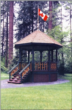
- Scope and Content
- Photographic postcard of the reconstructed Central Park Bandstand used to promote its official opening taking place May 29, 1996 (to be described).
- Repository
- City of Burnaby Archives
- Date
- 1996
- Collection/Fonds
- Burnaby Historical Society fonds
- Subseries
- Pixie McGeachie subseries
- Physical Description
- 1 photographic postcard : col.
- Description Level
- Item
- Record No.
- 332-002
- Access Restriction
- No restrictions
- Reproduction Restriction
- No restrictions
- Accession Number
- BHS1996-16
- Scope and Content
- Photographic postcard of the reconstructed Central Park Bandstand used to promote its official opening taking place May 29, 1996 (to be described).
- Media Type
- Photograph
- Geographic Access
- Central Park
- Imperial Street
- Street Address
- 3883 Imperial Street
- Historic Neighbourhood
- Central Park (Historic Neighbourhood)
- Planning Study Area
- Maywood Area
Images
Reconstructed Central Park Bandstand
https://search.heritageburnaby.ca/link/archivedescription58425
- Repository
- City of Burnaby Archives
- Date
- 1996
- Collection/Fonds
- Burnaby Historical Society fonds
- Description Level
- Item
- Physical Description
- 1 photographic postcard : col.
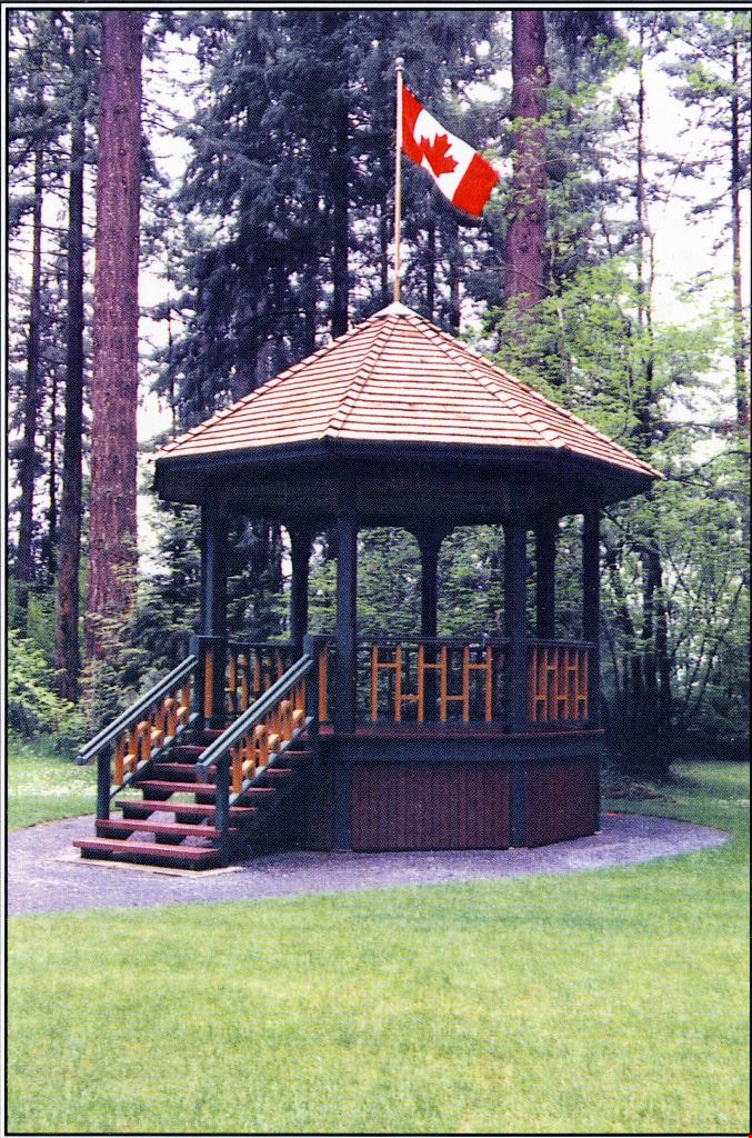
- Scope and Content
- Photographic postcard of the reconstructed Central Park Bandstand used to promote its official opening taking place May 29, 1996.
- Repository
- City of Burnaby Archives
- Date
- 1996
- Collection/Fonds
- Burnaby Historical Society fonds
- Subseries
- Pixie McGeachie subseries
- Physical Description
- 1 photographic postcard : col.
- Description Level
- Item
- Record No.
- 332-003
- Access Restriction
- No restrictions
- Reproduction Restriction
- Reproduce for fair dealing purposes only
- Accession Number
- BHS1996-16
- Scope and Content
- Photographic postcard of the reconstructed Central Park Bandstand used to promote its official opening taking place May 29, 1996.
- Media Type
- Photograph
- Geographic Access
- Central Park
- Imperial Street
- Street Address
- 3883 Imperial Street
- Historic Neighbourhood
- Central Park (Historic Neighbourhood)
- Planning Study Area
- Maywood Area
Images
Burnaby's Bandstand
https://search.heritageburnaby.ca/link/archivedescription64773
- Repository
- City of Burnaby Archives
- Date
- January 1998
- Collection/Fonds
- Burnaby Historical Society fonds
- Description Level
- Item
- Physical Description
- 1 videocassette (unknown length)
- Scope and Content
- Item is a VHS tape entitled “Burnaby's Bandstand / Jan. 1998."
- Repository
- City of Burnaby Archives
- Date
- January 1998
- Collection/Fonds
- Burnaby Historical Society fonds
- Subseries
- Municipal record subseries
- Physical Description
- 1 videocassette (unknown length)
- Material Details
- Video Home System (VHS) tape
- Description Level
- Item
- Record No.
- 597-001
- Access Restriction
- No restrictions
- Reproduction Restriction
- May be restricted by third party rights
- Accession Number
- BHS2004-13
- Scope and Content
- Item is a VHS tape entitled “Burnaby's Bandstand / Jan. 1998."
- Media Type
- Moving Images
- Notes
- Continuation of title: "...Jan. 1998"
- Geographic Access
- Central Park
- Imperial Street
- Street Address
- 3883 Imperial Street
- Historic Neighbourhood
- Central Park (Historic Neighbourhood)
- Planning Study Area
- Maywood Area
![Family in foggy Central Park, [1999] thumbnail](/media/hpo/_Data/_Archives_Images/_Unrestricted/535/535-3118-1.jpg?width=280)
Family in foggy Central Park
https://search.heritageburnaby.ca/link/archivedescription98038
- Repository
- City of Burnaby Archives
- Date
- [1999]
- Collection/Fonds
- Burnaby NewsLeader photograph collection
- Description Level
- File
- Physical Description
- 2 photographs (tiff) : col.
- Scope and Content
- File contains photographs of an unidentified family in Central Park in the fog. The photographs depict sun coming through the trees and the fog and the family, in silhouette, by water with ducks.
- Repository
- City of Burnaby Archives
- Date
- [1999]
- Collection/Fonds
- Burnaby NewsLeader photograph collection
- Physical Description
- 2 photographs (tiff) : col.
- Description Level
- File
- Record No.
- 535-3118
- Access Restriction
- No restrictions
- Reproduction Restriction
- No restrictions
- Accession Number
- 2018-12
- Scope and Content
- File contains photographs of an unidentified family in Central Park in the fog. The photographs depict sun coming through the trees and the fog and the family, in silhouette, by water with ducks.
- Subjects
- Persons - Families
- Geographic Features - Parks
- Geographic Features - Lakes and Ponds
- Natural Phenomena
- Names
- Central Park
- Media Type
- Photograph
- Photographer
- Bartel, Mario
- Notes
- Title based on caption
- Collected by editorial for use in a December 1999 issue of the Burnaby NewsLeader
- Caption from metadata: "The dense fog that blanketed the Lower Mainland for more than a week creates an eerie beauty at Central Park."
- Geographic Access
- Central Park
- Imperial Street
- Street Address
- 3883 Imperial Street
- Historic Neighbourhood
- Central Park (Historic Neighbourhood)
- Planning Study Area
- Maywood Area
Images
![Family in foggy Central Park, [1999] thumbnail](/media/hpo/_Data/_Archives_Images/_Unrestricted/535/535-3118-1.jpg)