
Central Park Neighbourhood
https://search.heritageburnaby.ca/link/landmark688
- Repository
- Burnaby Heritage Planning
- Associated Dates
- 1925-1954
- Heritage Value
- Although still largely a rural area during the 1920s, subdivisions began appearing in the Central Park neighbourhood at this time. Development was slowed by the Great Depression of the 1930s but the influx of commercial buildings and new housing initiatives in the post-war boom led to a period of rapid growth especially in the Garden Village subdivision which was undertaken in 1953 with the plan to build 500 modern homes in the 140-acre site. Despite the closure of the interurban line in 1953, the neighbourhood remained an active commercial and residential centre.
- Historic Neighbourhood
- Central Park (Historic Neighbourhood)
- Planning Study Area
- Maywood Area
Images


Central Park Neighbourhood
https://search.heritageburnaby.ca/link/landmark723
- Repository
- Burnaby Heritage Planning
- Associated Dates
- 1891-1904
- Heritage Value
- Central Park was one of the first and fastest-growing communities in Burnaby. Located along the electric tram line and the Vancouver Road (Kingsway), it was also chosen for a government settlement project referred to as the Central Park Small Holdings. The lands held by the Provincial Government were subdivided and sold around 1894 and by 1899 the settlement was large enough to warrant the construction of an Anglican Church there.
- Historic Neighbourhood
- Central Park (Historic Neighbourhood)
- Planning Study Area
- Maywood Area
Images


Central Park Neighbourhood
https://search.heritageburnaby.ca/link/landmark751
- Repository
- Burnaby Heritage Planning
- Associated Dates
- 1905-1924
- Heritage Value
- In 1906, Maxwell Smith, President of the Central Park Farmer's Institute gave a speech in which he commented on the growth of this district and its ideal location during the boom years after 1905. He said: "Central Park is destined to become the epicentre of a great commercial metropolis, when Vancouver and New Westminster will have both expanded and prospered until they meet and fill up the intervening distances with residences of a new city, greater than few can now imagine, even in their wildest flights of fancy...we are proud of the two cities that lie on either side of us but they are, but mere hamlets compared with the great city that is to be on this peninsula. The time is coming when there will be one vast city, one commercial metropolis, and Central Park will be the heart of it."
- Historic Neighbourhood
- Central Park (Historic Neighbourhood)
- Planning Study Area
- Maywood Area
Images


Maywood Neighbourhood
https://search.heritageburnaby.ca/link/landmark801
- Repository
- Burnaby Heritage Planning
- Associated Dates
- 1955-2008
- Heritage Value
- Burnaby's Maywood Neighbourhood consists of the Metrotown Town Centre - one of four Town Centres in the City. Metrotown is one of the region's most developed and fastest growing centres. It is served by the first SkyTrain line developed in the mid-1980s and anchored by B.C.'s largest shopping and entertainment complex. As an older centre that has progressively added new developments over the years, Metrotown offers a range of housing types and tenures from three-storey walk-up apartments to modern residential towers.
- Historic Neighbourhood
- Central Park (Historic Neighbourhood)
- Planning Study Area
- Maywood Area
Images

![Gilley Brothers Logging team, [1895]. . thumbnail](/media/hpo/_Data/_Archives_Images/_Unrestricted/371/461-003.jpg?width=280)
Vancouver Road (Kingsway)
https://search.heritageburnaby.ca/link/landmark729
- Repository
- Burnaby Heritage Planning
- Associated Dates
- 1860
- Heritage Value
- The street we know as Kingsway is one of the legacies of the Royal Engineers' military defences for New Westminster. The fear of an American attack prompted the construction of the False Creek trail - later known as Vancouver Road and now Kingsway - in 1860 to connect the capital city to the ice-free salt water harbour at English Bay.
- Historic Neighbourhood
- Central Park (Historic Neighbourhood)
- Edmonds (Historic Neighbourhood)
- Planning Study Area
- Maywood Area
- Marlborough Area
- Windsor Area
- Kingsway-Beresford Area
- Stride Avenue Area
- Edmonds Area
Images
![Gilley Brothers Logging team, [1895]. . thumbnail](/media/hpo/_Data/_Archives_Images/_Unrestricted/371/461-003.jpg)

Central Park
https://search.heritageburnaby.ca/link/landmark728
- Repository
- Burnaby Heritage Planning
- Geographic Access
- Imperial Street
- Associated Dates
- 1891
- Heritage Value
- In 1860, as the Royal Engineers constructed the road from New Westminster to Vancouver (now Kingsway), a military reserve was set aside at the trail's highest point along the ridge. This reserve provided a particularly good scenic look-out since the original forest had burned down prior to 1860, the remaining stumps offered unobstructed views. By the 1880s, the city council of both New Westminster and Vancouver eyed the reserve as potential recreation ground. As construction of the tram line was underway, the Provincial Government moved to designate the whole reserve as a park. On January 14, 1891, the Lieutenant Governor of British Columbia proclaimed it as a public recreation ground.
- Historic Neighbourhood
- Central Park (Historic Neighbourhood)
- Planning Study Area
- Maywood Area
- Street Address
- 3883 Imperial Street
- Street View URL
- Google Maps Street View
Images


Central Park Tramline
https://search.heritageburnaby.ca/link/landmark732
- Repository
- Burnaby Heritage Planning
- Associated Dates
- 1891
- Heritage Value
- In the 1890s, local entrepreneurs launched electric railways in Vancouver, New Westminster, and Victoria, eager to cash in on the promise of future growth in the major cities of the time. In the Lower Mainland, two companies started building electric rail in 1890: the Westminster and Vancouver Tramway Co., which undertook the ambitious project of building the first real interurban line from New Westminster to Vancouver, and the Westminster Street Railway, who eventually built streetcar service and installed electric lighting in New Westminster. By April 20, 1891, both companies merged to form the Westminster and Vancouver Tramway Company. Local entrepreneurs Henry V. Edmonds, David Oppenheimer, Benjamin Douglas, and Samuel McIntosh, were the directors, all of whom had extensive real estate holdings in the area. Interurban service launched on June 3, 1891, travelling along 12 miles of track from New Westminster to eastern Vancouver, running through Burnaby – which was then an unincorporated area. Installing the single-track line from Vancouver to New Westminster through uneven, forested terrain was a mammoth undertaking. The clearing of the 100-foot right of way and laying the track called for a large work force, some of whom were Chinese "gandy dancers" who had worked on the Canadian Pacific Railway lines. The line was eventually taken over by the B.C. Electric Railway Company in 1897, who remained the owners until the line was finally closed on October 23, 1953 and replaced with the modern bus system. The construction of the SkyTrain along the old route in 1986 reintroduced passenger rail to this historic transportation corridor.
- Historic Neighbourhood
- Central Park (Historic Neighbourhood)
- Planning Study Area
- Maywood Area
Images


West Burnaby School (aka Kingsway West School)
https://search.heritageburnaby.ca/link/landmark727
- Repository
- Burnaby Heritage Planning
- Geographic Access
- Kingsway
- Associated Dates
- 1896
- Heritage Value
- West Burnaby School was to be Burnaby's second public school and it served the children who lived along the tram line and Vancouver Road (Kingsway).
- Historic Neighbourhood
- Central Park (Historic Neighbourhood)
- Planning Study Area
- Maywood Area
- Street View URL
- Google Maps Street View
Images

West Burnaby School class
https://search.heritageburnaby.ca/link/archivedescription36019
- Repository
- City of Burnaby Archives
- Date
- 1898
- Collection/Fonds
- Burnaby Historical Society fonds
- Description Level
- Item
- Physical Description
- 1 photograph : sepia ; 19.5 x 24 cm, mounted on board 25 x 30 cm
- Scope and Content
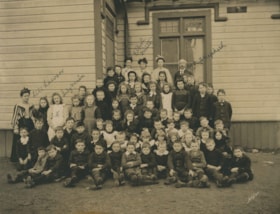
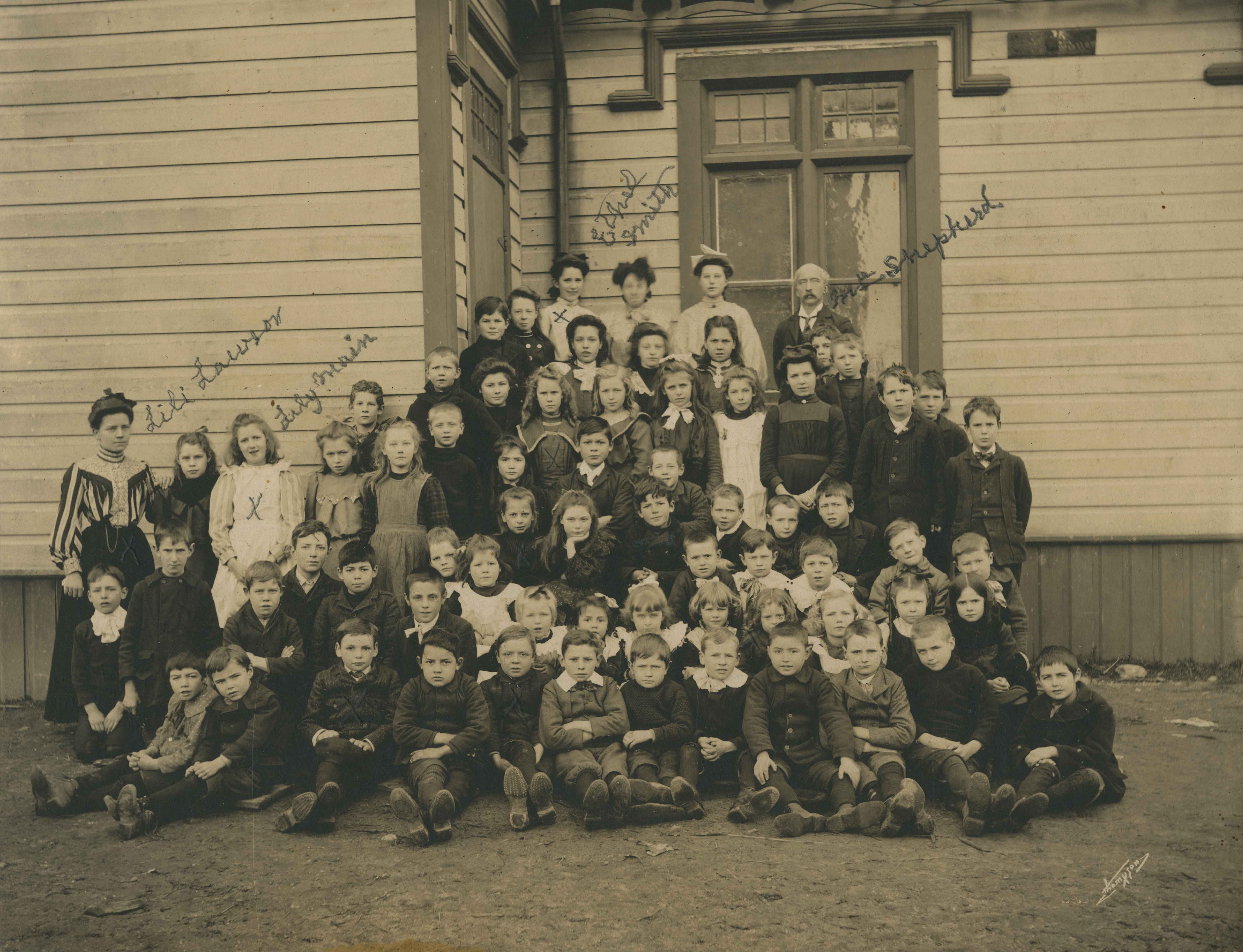
- Photograph of the West Burnaby School class, including teachers, lined up in rows on the porch steps, with the first row seated on the ground with their feet crossed in front of them. Individuals that have been identified, in pencil, directly on the photograph include; Teacher Lili Lawson (far left…
- Repository
- City of Burnaby Archives
- Date
- 1898
- Collection/Fonds
- Burnaby Historical Society fonds
- Subseries
- Patterson family subseries
- Physical Description
- 1 photograph : sepia ; 19.5 x 24 cm, mounted on board 25 x 30 cm
- Description Level
- Item
- Record No.
- 213-001
- Access Restriction
- No restrictions
- Reproduction Restriction
- No known restrictions
- Accession Number
- BHS1988-13
- Scope and Content
- Photograph of the West Burnaby School class, including teachers, lined up in rows on the porch steps, with the first row seated on the ground with their feet crossed in front of them. Individuals that have been identified, in pencil, directly on the photograph include; Teacher Lili Lawson (far left), Lily Main (two over from Lawson), Ethel Smith (far left in the back row), and Headmaster Samuel Shepard (far right in the back row). Members of the Patterson family are also in this photograph; William (Bill) is sitting in the front row, third from the left, Bruce is sitting two to the right of Bill, with Alice two rows directly behind Bruce (her hair is shorter than the other girls and she is wearing a dark shirt), with their older sister Mary standing two rows directly behind Alice. The school was later renamed Kingsway West School and remained in operations until 1952.
- Subjects
- Occupations - Teachers
- Media Type
- Photograph
- Notes
- Title based on contents of photograph
- Photographer identified as "Thompson"
- Geographic Access
- Kingsway
- Street Address
- 4800 Kingsway
- Historic Neighbourhood
- Central Park (Historic Neighbourhood)
- Planning Study Area
- Maywood Area
Images
![West Burnaby School, [1898] thumbnail](/media/hpo/_Data/_Archives_Images/_Unrestricted/251/297-001.jpg?width=280)
West Burnaby School
https://search.heritageburnaby.ca/link/archivedescription36571
- Repository
- City of Burnaby Archives
- Date
- [1898]
- Collection/Fonds
- Burnaby Historical Society fonds
- Description Level
- Item
- Physical Description
- 1 photograph : sepia ; 18.5 x 23.5 cm, mounted on board 21.5 x 25 cm + 1p. accompanying
- Scope and Content
- Photograph of West Burnaby School students standing outside in front of their school in two long rows, with their teacher and school staff members standing on the right. Daisy Birchell is the smallest in the group, standing in the front row, eighth from the left, and her cousin is standing beside h…
- Repository
- City of Burnaby Archives
- Date
- [1898]
- Collection/Fonds
- Burnaby Historical Society fonds
- Subseries
- Photographs subseries
- Physical Description
- 1 photograph : sepia ; 18.5 x 23.5 cm, mounted on board 21.5 x 25 cm + 1p. accompanying
- Description Level
- Item
- Record No.
- 297-001
- Access Restriction
- No restrictions
- Reproduction Restriction
- No known restrictions
- Accession Number
- BHS1992-37
- Scope and Content
- Photograph of West Burnaby School students standing outside in front of their school in two long rows, with their teacher and school staff members standing on the right. Daisy Birchell is the smallest in the group, standing in the front row, eighth from the left, and her cousin is standing beside her, ninth from the left. The school was later renamed Kingsway West School and remained in operations until 1952.
- Subjects
- Buildings - Schools
- Media Type
- Photograph
- Notes
- Title based on contents of photograph
- Note in accompanying material states that the photograph is the property of Charles Burchell's family, and "children as pupils" were; William, Frederick, Lily, and Daisy Burchell.
- Geographic Access
- Kingsway
- Street Address
- 4800 Kingsway
- Historic Neighbourhood
- Central Park (Historic Neighbourhood)
- Planning Study Area
- Maywood Area
Images
![West Burnaby School, [1898] thumbnail](/media/hpo/_Data/_Archives_Images/_Unrestricted/251/297-001.jpg)
West Burnaby School class outside
https://search.heritageburnaby.ca/link/archivedescription37334
- Repository
- City of Burnaby Archives
- Date
- 1898
- Collection/Fonds
- Burnaby Historical Society fonds
- Description Level
- Item
- Physical Description
- 1 photograph : sepia ; 20.5 x 25.3 cm on 30.5 x 37.5 cm mat
- Scope and Content
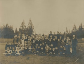
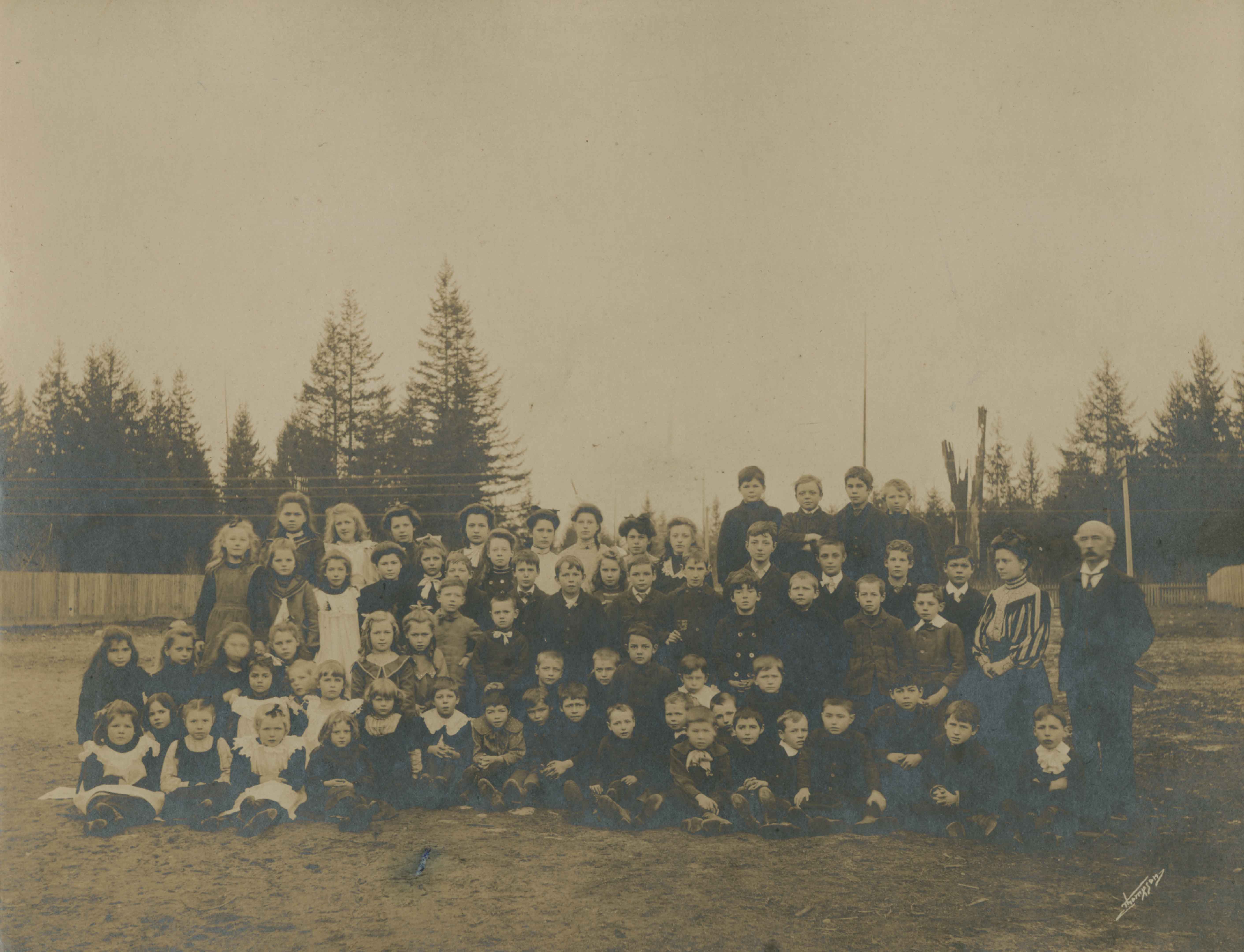
- Photograph of the West Burnaby School class, including teachers, on the dirt field next to the school. Eight of the individuals have been identified; sitting in the second row, second from the left is (8) Alice Patterson, standing in the center of the third row is (4) William (Bill) Pattterson, and…
- Repository
- City of Burnaby Archives
- Date
- 1898
- Collection/Fonds
- Burnaby Historical Society fonds
- Subseries
- Millway family subseries
- Physical Description
- 1 photograph : sepia ; 20.5 x 25.3 cm on 30.5 x 37.5 cm mat
- Description Level
- Item
- Record No.
- 353-001
- Access Restriction
- No restrictions
- Reproduction Restriction
- No known restrictions
- Accession Number
- BHS1997-12
- Scope and Content
- Photograph of the West Burnaby School class, including teachers, on the dirt field next to the school. Eight of the individuals have been identified; sitting in the second row, second from the left is (8) Alice Patterson, standing in the center of the third row is (4) William (Bill) Pattterson, and in the back row on the far left is (7) Mary Patterson, beside her, (6) Lily Main, three from Lily is (5)Ethel Smith, and third from the right in the same row is (3) Bruce Patterson. The school headmaster (1) Samuel Shepard is standing on the far right and standing next to him is their teacher, (2) Lily Smith. The school was later renamed Kingsway West School and remained in operations until 1952.
- Subjects
- Occupations - Teachers
- Names
- Kingsway West School
- Media Type
- Photograph
- Notes
- Title based on contents of photograph
- Photographer identified as "Thompson"
- Geographic Access
- Kingsway
- Street Address
- 4800 Kingsway
- Historic Neighbourhood
- Central Park (Historic Neighbourhood)
- Planning Study Area
- Maywood Area
Images
![Dallamore Family Home, [1900] (date of original), copied 1986 thumbnail](/media/hpo/_Data/_Archives_Images/_Unrestricted/204/204-130.jpg?width=280)
Dallamore Family Home
https://search.heritageburnaby.ca/link/archivedescription35273
- Repository
- City of Burnaby Archives
- Date
- [1900] (date of original), copied 1986
- Collection/Fonds
- Burnaby Historical Society fonds
- Description Level
- Item
- Physical Description
- 1 photograph : b&w ; 12.7 x 17.8 cm print
- Scope and Content
- Photograph of the Dallamore family home on Silver Avenue near the B.C. Electric interurban tracks. Grace Dallamore's grandparents, the Harmers, and her parents, the Dallamores, owned this entire block of land. This house was built ca. 1896 by F.L. Harmer, a carpenter who settled in Burnaby in 189…
- Repository
- City of Burnaby Archives
- Date
- [1900] (date of original), copied 1986
- Collection/Fonds
- Burnaby Historical Society fonds
- Subseries
- Pioneer Tales subseries
- Physical Description
- 1 photograph : b&w ; 12.7 x 17.8 cm print
- Description Level
- Item
- Record No.
- 204-130
- Access Restriction
- No restrictions
- Reproduction Restriction
- No known restrictions
- Accession Number
- BHS1988-03
- Scope and Content
- Photograph of the Dallamore family home on Silver Avenue near the B.C. Electric interurban tracks. Grace Dallamore's grandparents, the Harmers, and her parents, the Dallamores, owned this entire block of land. This house was built ca. 1896 by F.L. Harmer, a carpenter who settled in Burnaby in 1894.
- Media Type
- Photograph
- Notes
- Title based on contents of photograph
- Geographic Access
- Silver Avenue
- Street Address
- 6380 Silver Avenue
- Historic Neighbourhood
- Central Park (Historic Neighbourhood)
- Planning Study Area
- Maywood Area
Images
![Dallamore Family Home, [1900] (date of original), copied 1986 thumbnail](/media/hpo/_Data/_Archives_Images/_Unrestricted/204/204-130.jpg)
![Wilson family home, [190-] (date of original), copied 1986 thumbnail](/media/hpo/_Data/_Archives_Images/_Unrestricted/204/204-641.jpg?width=280)
Wilson family home
https://search.heritageburnaby.ca/link/archivedescription35783
- Repository
- City of Burnaby Archives
- Date
- [190-] (date of original), copied 1986
- Collection/Fonds
- Burnaby Historical Society fonds
- Description Level
- Item
- Physical Description
- 1 photograph : b&w ; 12.7 x 17.8 cm print
- Scope and Content
- Photograph of the Wilson family home on Westminster Road (now 4330 Kingsway) and Wilson Avenue (named after the family) near Central Park. Left to right: unidentified friend, Mrs. Annie Walmsley Wilson (mother), Annie Walmsley (half-sister, born to Annie Wilson and first husband, Samuel Walmsley),…
- Repository
- City of Burnaby Archives
- Date
- [190-] (date of original), copied 1986
- Collection/Fonds
- Burnaby Historical Society fonds
- Subseries
- Pioneer Tales subseries
- Physical Description
- 1 photograph : b&w ; 12.7 x 17.8 cm print
- Description Level
- Item
- Record No.
- 204-641
- Access Restriction
- No restrictions
- Reproduction Restriction
- No restrictions
- Accession Number
- BHS1988-03
- Scope and Content
- Photograph of the Wilson family home on Westminster Road (now 4330 Kingsway) and Wilson Avenue (named after the family) near Central Park. Left to right: unidentified friend, Mrs. Annie Walmsley Wilson (mother), Annie Walmsley (half-sister, born to Annie Wilson and first husband, Samuel Walmsley), and Elsie Wilson (half-sister).
- Subjects
- Buildings - Residential - Houses
- Media Type
- Photograph
- Notes
- Title based on contents of photograph
- Geographic Access
- Westminster Avenue
- Kingsway
- Street Address
- 4330 Kingsway
- Historic Neighbourhood
- Central Park (Historic Neighbourhood)
- Planning Study Area
- Maywood Area
Images
![Wilson family home, [190-] (date of original), copied 1986 thumbnail](/media/hpo/_Data/_Archives_Images/_Unrestricted/204/204-641.jpg)
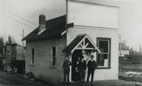
![Dow, Fraser and Company Limited, [1900] (date of original), copied 1992 thumbnail](/media/hpo/_Data/_Archives_Images/_Unrestricted/315/315-072.jpg?width=280)
Dow, Fraser and Company Limited
https://search.heritageburnaby.ca/link/archivedescription36717
- Repository
- City of Burnaby Archives
- Date
- [1900] (date of original), copied 1992
- Collection/Fonds
- Burnaby Historical Society fonds
- Description Level
- Item
- Physical Description
- 1 photograph : b&w ; 7.7 x 10.6 cm print
- Scope and Content
- Photograph of the exterior of the Dow, Fraser & Co. Ltd. branch building on McKay Avenue with a man standing outside. Signs on the building state that it is a trust company and advertise real estate, loans, and fire insurance.
- Repository
- City of Burnaby Archives
- Date
- [1900] (date of original), copied 1992
- Collection/Fonds
- Burnaby Historical Society fonds
- Subseries
- Burnaby Centennial Anthology subseries
- Physical Description
- 1 photograph : b&w ; 7.7 x 10.6 cm print
- Description Level
- Item
- Record No.
- 315-072
- Access Restriction
- No restrictions
- Reproduction Restriction
- No known restrictions
- Accession Number
- BHS1994-04
- Scope and Content
- Photograph of the exterior of the Dow, Fraser & Co. Ltd. branch building on McKay Avenue with a man standing outside. Signs on the building state that it is a trust company and advertise real estate, loans, and fire insurance.
- Media Type
- Photograph
- Notes
- Title based on contents of photograph
- Item no. 315-071 is a closeup of this photograph
- Geographic Access
- McKay Avenue
- Willingdon Avenue
- Street Address
- 6100 Willingdon Avenue
- Historic Neighbourhood
- Central Park (Historic Neighbourhood)
- Planning Study Area
- Maywood Area
Images
![Dow, Fraser and Company Limited, [1900] (date of original), copied 1992 thumbnail](/media/hpo/_Data/_Archives_Images/_Unrestricted/315/315-072.jpg)
West Burnaby School Class
https://search.heritageburnaby.ca/link/archivedescription34519
- Repository
- City of Burnaby Archives
- Date
- 1904
- Collection/Fonds
- Burnaby Historical Society fonds
- Description Level
- Item
- Physical Description
- 1 photograph : b&w ; 12.8 x 17.8 cm mounted on cardboard 20.0 x 25.0 cm
- Scope and Content
- Photograph of a West Burnaby School (later renamed Kingsway West School) class standing outside of the school. Identified, back row, left to right: [unidentified], Georgina Bell, [first name unknown] Creamer, Gladys Bisset, Bernadette McNeil, Elsie Wilson, and Mabel Rowlinson. 2nd row, 5th from le…
- Repository
- City of Burnaby Archives
- Date
- 1904
- Collection/Fonds
- Burnaby Historical Society fonds
- Subseries
- Elsie B. Wilson subseries
- Physical Description
- 1 photograph : b&w ; 12.8 x 17.8 cm mounted on cardboard 20.0 x 25.0 cm
- Description Level
- Item
- Record No.
- 034-001
- Access Restriction
- No restrictions
- Reproduction Restriction
- No known restrictions
- Accession Number
- BHS2007-04
- Scope and Content
- Photograph of a West Burnaby School (later renamed Kingsway West School) class standing outside of the school. Identified, back row, left to right: [unidentified], Georgina Bell, [first name unknown] Creamer, Gladys Bisset, Bernadette McNeil, Elsie Wilson, and Mabel Rowlinson. 2nd row, 5th from left: Edith Marten. 3rd row, left to right: [first name unknown] McMaster, [unidentified], Jean Ross, [unidentified], Goldie Ralph, Mabel Ralph, Grace Marten, [3 unidentified children], Lois Rumble (later Wilson), [unidentified], and George Robertson. From row, left to right, starting at 7th child: Wilson Bailey, [first name unknown] Bond, [2 unidentified children], Bill Smith, Elgin Robertson, [2 unidentified children], Gordon Bailey, [2 unidentified children], [first name unknown] Bramble. The teacher, standing at the back left, is Miss Annie Theresa Forrest.
- Subjects
- Occupations - Teachers
- Names
- Bailey, Gordon
- Bailey, Wilson
- Bell, Georgina
- Bisset, Gladys
- Forrest, Annie Theresa
- Marten, Edith
- Marten, Grace
- McNeil, Bernadette
- Ralph, Mabel
- Robertson, Elgin
- Robertson, George
- Ross, Jean
- Rowlinson, Mabel
- Wilson, Lois Rumble
- Smith, Bill
- Kingsway West School
- Wilson, Elsie
- Media Type
- Photograph
- Notes
- Title based on contents of photograph
- Geographic Access
- Kingsway
- Street Address
- 4800 Kingsway
- Historic Neighbourhood
- Central Park (Historic Neighbourhood)
- Planning Study Area
- Maywood Area
Images

Topping a tree near Central Park
https://search.heritageburnaby.ca/link/archivedescription37280
- Repository
- City of Burnaby Archives
- Date
- 1904
- Collection/Fonds
- Burnaby Historical Society fonds
- Description Level
- Item
- Physical Description
- 1 photograph : sepia toned ; 21 x 26.5 cm
- Scope and Content
- Photograph of a man "topping" a large tree in the area near Central Park and Boundary Road.
- Repository
- City of Burnaby Archives
- Date
- 1904
- Collection/Fonds
- Burnaby Historical Society fonds
- Subseries
- Norah Code subseries
- Physical Description
- 1 photograph : sepia toned ; 21 x 26.5 cm
- Description Level
- Item
- Record No.
- 345-001
- Access Restriction
- No restrictions
- Reproduction Restriction
- No known restrictions
- Accession Number
- BHS1997-05
- Scope and Content
- Photograph of a man "topping" a large tree in the area near Central Park and Boundary Road.
- Media Type
- Photograph
- Photographer
- Code, Norah
- Notes
- Title based on contents of photograph
- Photographs in this collection were taken and compiled by Norah Code, former editor of the "Burnaby Courier" newspaper during the course of her work for the newspaper. A note with the file indicates that the man in the tree may be Ms. Code's father but his name is not provided.
- Geographic Access
- Boundary Road
- Central Park
- Historic Neighbourhood
- Central Park (Historic Neighbourhood)
- Planning Study Area
- Maywood Area
Images

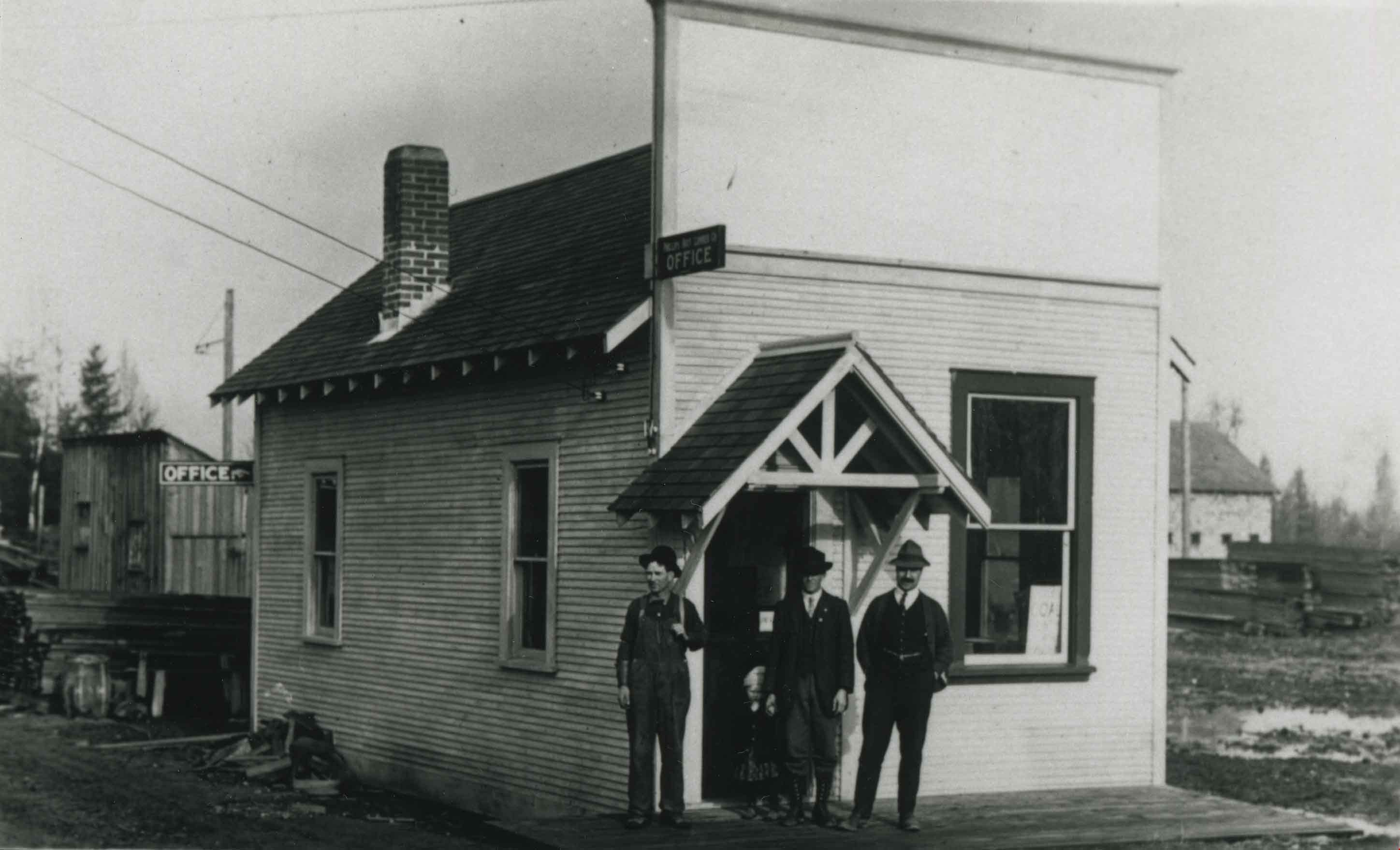
![Phillips-Hoyt Lumber Company, [1905] (date of original), copied 1992 thumbnail](/media/hpo/_Data/_Archives_Images/_Unrestricted/315/315-070.jpg?width=280)
Phillips-Hoyt Lumber Company
https://search.heritageburnaby.ca/link/archivedescription36715
- Repository
- City of Burnaby Archives
- Date
- [1905] (date of original), copied 1992
- Collection/Fonds
- Burnaby Historical Society fonds
- Description Level
- Item
- Physical Description
- 1 photograph : b&w ; 8.3 x 12.0 cm print
- Scope and Content
- Photograph of the exterior of the building housing the Phillips, Hoyt Lumber Co. office with three men standing outside. The building was located at 2730 McKay Avenue (old street numbering system) and the site is now a part of the Burnaby Public Library site.
- Repository
- City of Burnaby Archives
- Date
- [1905] (date of original), copied 1992
- Collection/Fonds
- Burnaby Historical Society fonds
- Subseries
- Burnaby Centennial Anthology subseries
- Physical Description
- 1 photograph : b&w ; 8.3 x 12.0 cm print
- Description Level
- Item
- Record No.
- 315-070
- Access Restriction
- No restrictions
- Reproduction Restriction
- No known restrictions
- Accession Number
- BHS1994-04
- Scope and Content
- Photograph of the exterior of the building housing the Phillips, Hoyt Lumber Co. office with three men standing outside. The building was located at 2730 McKay Avenue (old street numbering system) and the site is now a part of the Burnaby Public Library site.
- Subjects
- Buildings - Commercial
- Media Type
- Photograph
- Notes
- Title based on contents of photograph
- Geographic Access
- Willingdon Avenue
- Street Address
- 6100 Willingdon Avenue
- Historic Neighbourhood
- Central Park (Historic Neighbourhood)
- Planning Study Area
- Maywood Area
Images
![Phillips-Hoyt Lumber Company, [1905] (date of original), copied 1992 thumbnail](/media/hpo/_Data/_Archives_Images/_Unrestricted/315/315-070.jpg)
Phillips-Hoyt Lumber Company
https://search.heritageburnaby.ca/link/archivedescription36766
- Repository
- City of Burnaby Archives
- Date
- 1905 (date of original), copied 1992
- Collection/Fonds
- Burnaby Historical Society fonds
- Description Level
- Item
- Physical Description
- 1 photograph : b&w ; 7.9 x 12.5 cm print
- Scope and Content
- Photograph of the exterior of the Phillips, Hoyt Lumber Co. on McKay Avenue with three men standing in front. This property is now part of the Burnaby Public Library site.
- Repository
- City of Burnaby Archives
- Date
- 1905 (date of original), copied 1992
- Collection/Fonds
- Burnaby Historical Society fonds
- Subseries
- Burnaby Centennial Anthology subseries
- Physical Description
- 1 photograph : b&w ; 7.9 x 12.5 cm print
- Description Level
- Item
- Record No.
- 315-121
- Access Restriction
- No restrictions
- Reproduction Restriction
- No known restrictions
- Accession Number
- BHS1994-04
- Scope and Content
- Photograph of the exterior of the Phillips, Hoyt Lumber Co. on McKay Avenue with three men standing in front. This property is now part of the Burnaby Public Library site.
- Subjects
- Buildings - Commercial
- Media Type
- Photograph
- Notes
- Title based on contents of photograph
- Geographic Access
- McKay Avenue
- Willingdon Avenue
- Street Address
- 6100 Willingdon Avenue
- Historic Neighbourhood
- Central Park (Historic Neighbourhood)
- Planning Study Area
- Maywood Area
Images
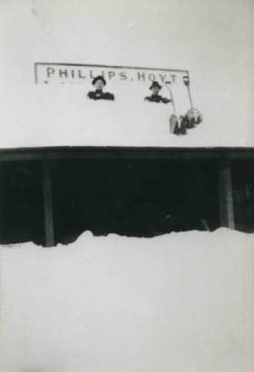
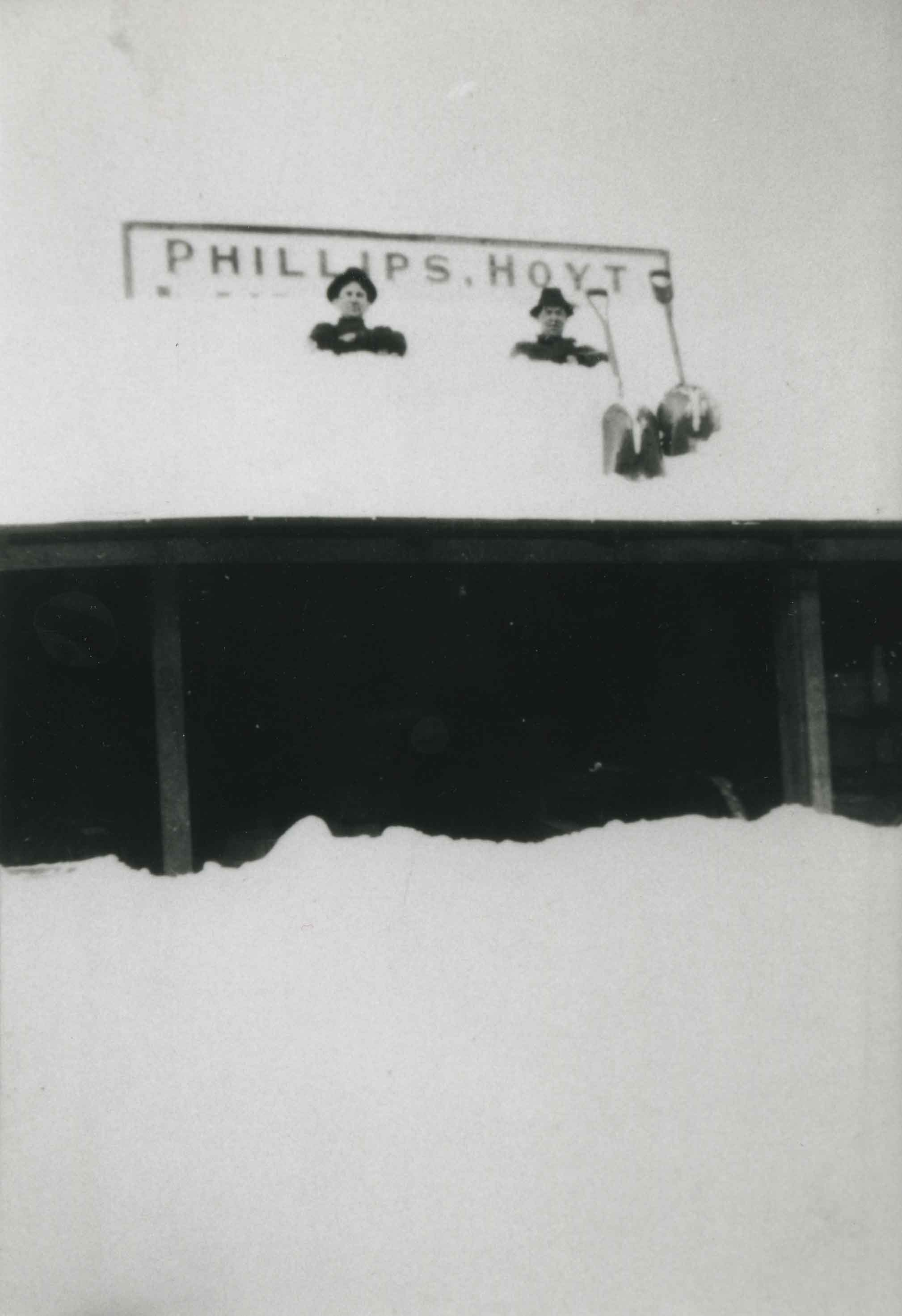
Phillips-Hoyt Lumber Company after snowfall
https://search.heritageburnaby.ca/link/archivedescription36769
- Repository
- City of Burnaby Archives
- Date
- 1905 (date of original), copied 1992
- Collection/Fonds
- Burnaby Historical Society fonds
- Description Level
- Item
- Physical Description
- 1 photograph : b&w ; 12.6 x 8.7 cm print
- Scope and Content
- Photograph of a building of the Phillips, Hoyt Lumber Co. after a snowfall. Two men are on the roof of the building with shovels.
- Repository
- City of Burnaby Archives
- Date
- 1905 (date of original), copied 1992
- Collection/Fonds
- Burnaby Historical Society fonds
- Subseries
- Burnaby Centennial Anthology subseries
- Physical Description
- 1 photograph : b&w ; 12.6 x 8.7 cm print
- Description Level
- Item
- Record No.
- 315-124
- Access Restriction
- No restrictions
- Reproduction Restriction
- No known restrictions
- Accession Number
- BHS1994-04
- Scope and Content
- Photograph of a building of the Phillips, Hoyt Lumber Co. after a snowfall. Two men are on the roof of the building with shovels.
- Subjects
- Buildings - Commercial
- Media Type
- Photograph
- Notes
- Title based on contents of photograph
- Geographic Access
- McKay Avenue
- Willingdon Avenue
- Street Address
- 6100 Willingdon Avenue
- Historic Neighbourhood
- Central Park (Historic Neighbourhood)
- Planning Study Area
- Maywood Area
Images
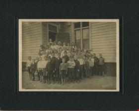
![Division II at West Burnaby School, [1906 or 1907] thumbnail](/media/hpo/_Data/_Archives_Images/_Unrestricted/001/034-002.jpg?width=280)
Division II at West Burnaby School
https://search.heritageburnaby.ca/link/archivedescription34520
- Repository
- City of Burnaby Archives
- Date
- [1906 or 1907]
- Collection/Fonds
- Burnaby Historical Society fonds
- Description Level
- Item
- Physical Description
- 1 photograph : b&w postcard ; 7.5 x 13 cm + 1 p.
- Scope and Content
- Photographic postcard of Division II at West Burnaby School (later renamed Kingsway West School) sitting and standing outside. Standing in the back row third from the left is Lillian Bond, beside her is [first name unknown] Barber, Eva Coburne, Mabel Ralph, [first name unknown] Bramble, George Robe…
- Repository
- City of Burnaby Archives
- Date
- [1906 or 1907]
- Collection/Fonds
- Burnaby Historical Society fonds
- Subseries
- Elsie B. Wilson subseries
- Physical Description
- 1 photograph : b&w postcard ; 7.5 x 13 cm + 1 p.
- Description Level
- Item
- Record No.
- 034-002
- Access Restriction
- No restrictions
- Reproduction Restriction
- No known restrictions
- Accession Number
- BHS2007-04
- Scope and Content
- Photographic postcard of Division II at West Burnaby School (later renamed Kingsway West School) sitting and standing outside. Standing in the back row third from the left is Lillian Bond, beside her is [first name unknown] Barber, Eva Coburne, Mabel Ralph, [first name unknown] Bramble, George Robertson, Mabel Rowlinson, unidentified, Georgina Bell, Bright Robertson and Fred Bond. Fourth from the left in the second row is Glen McMaster, sixth is Lois Rumble (later Wilson), beside her is Margaret Creamer, Gladys Bisset, Amy Sandell, unidentified, Elgin Robertson, unidentified and Bill Smith. Sitting in the front row, third from the left is Goldie Ralph, beside her is Edith Marten, unidentified, Jessie Robertson, [first name unknown] McMaster, Grace Marten, Elsie Wilson, Beatrice Barber, Dora Barber, Jean Ross and Dolly Smith. John Robertson is sitting on the ground, on the far left and Miss Annie Theresa Forrest is standing on the far left behind her students (next to her is a bicycle).
- Names
- Barber, Dora
- Bell, Georgina
- Bisset, Gladys
- Bond, Fred
- Bond, Lillian
- Coburne, Eva
- Creamer, Margaret
- Forrest, Annie Theresa
- Marten, Edith
- Marten, Grace
- McMaster, Glen
- Ralph, Goldie
- Ralph, Mabel
- Robertson, Bright
- Robertson, Elgin
- Robertson, George
- Robertson, Jessie
- Robertson, John
- Ross, Jean
- Rowlinson, Mabel
- Wilson, Lois Rumble
- Sandell, Amy
- Smith, Bill
- Smith, Dolly
- Wilson, Elsie
- Kingsway West School
- Media Type
- Photograph
- Photographer
- Barrowclough, G.A.
- Notes
- Title based on contents of photograph
- Printed by photographer on recto of photograph: "2nd Div. West Burnaby School / Barrowclough Cards"
- 1 page accompanying lists the individuals in the photograph as: "Back row, l to r: 3rd, Lillian Bond; 4th, [first name unknown] Barber; 5th, Eva Coburne; 6th, Mabel Ralph; 7th, [first name unknown] Bramble; 8th, George Robertson; 10th, Mabel Rowlinson; 12th, Georgina Bell; 13th Bright Robertson; and 14th, Fred Bond. Second row, l to r: 4th, Glen McMaster; 6th, Lois Rumble; 7th, Margaret Creamer; 8th, Gladys Bisset; 9th, Amy Sandell; 11th, Elgin Robertson; and 13th, Bill Smith. First row, l to r: 3rd, Goldie Ralph; 4th, Edith Marten; 6th, Jessie Robertson; 7th, [first name unknown] McMaster; 8th, Grace Marten; 9th, Elsie Wilson; 10th, Beatrice Barber; 11th, Dora Barber; 12th, Jean Ross; and 13th, Dolly Smith. Seated on ground, left to right: 1st, John Robertson."
- Geographic Access
- Kingsway
- Street Address
- 4800 Kingsway
- Historic Neighbourhood
- Central Park (Historic Neighbourhood)
- Planning Study Area
- Maywood Area
Images
![Division II at West Burnaby School, [1906 or 1907] thumbnail](/media/hpo/_Data/_Archives_Images/_Unrestricted/001/034-002.jpg)