Narrow Results By

Central Park Entrance Gate
https://search.heritageburnaby.ca/link/landmark544
- Repository
- Burnaby Heritage Planning
- Description
- The Central Park Entrance Gate is the ceremonial entrance to Burnaby’s historic Central Park from Kingsway, and consists of two massive stone pillars, approximately 7.5 metres high and 1.8 metres square, adjacent gate posts and a low flanking stone wall that curves into the park to the east.
- Associated Dates
- 1913
- Formal Recognition
- Heritage Designation, Community Heritage Register
- Street View URL
- Google Maps Street View
- Repository
- Burnaby Heritage Planning
- Geographic Access
- Imperial Street
- Associated Dates
- 1913
- Formal Recognition
- Heritage Designation, Community Heritage Register
- Enactment Type
- Bylaw No. 9807
- Enactment Date
- 23/11/1992
- Description
- The Central Park Entrance Gate is the ceremonial entrance to Burnaby’s historic Central Park from Kingsway, and consists of two massive stone pillars, approximately 7.5 metres high and 1.8 metres square, adjacent gate posts and a low flanking stone wall that curves into the park to the east.
- Heritage Value
- The Central Park Entrance Gate is significant as a ceremonial entry to a major park, for its connection with the early history of the British Columbia Electric Railway (BCER) and as an important design by an accomplished British Columbian architect. When the original interurban line between Vancouver and New Westminster was constructed in 1891, one of the first stations was located where the tramway crossed the Vancouver-Westminster Road (now Kingsway) within the newly-created Central Park. The interurban line ran through the park on a diagonal right-of-way (the current SkyTrain line, opened in 1986, follows this original alignment). In 1912 an agreement was reached between the successor interurban company, the BCER, and the Central Park Provincial Park Board, to deed additional land for an expanded right-of-way through the Park in exchange for improvements that included the construction of an ornamental stone wall and gate with an iron arch, with an illuminated 'Central Park' sign, adjacent to the interurban station on Kingsway. This was an early and rare example of an electric sign used for a public recreation facility. The Gate is also significant as a surviving early design by Robert Lyon (1879-1963), an Edinburgh-born and trained immigrant who was one of the most accomplished of British Columbia's early architects. After he moved to Vancouver, he was employed by the BCER from 1911 until 1918, and worked on a broad range of projects including some of the grandest and most innovative local industrial structures of the time. The arch was built by the Westminster Ironworks Company, one of the leading firms of its kind in Western Canada, operated by John Reid of New Westminster. The Gate was completed in 1914; in 1968 the decorative ironwork was removed due to corrosion and placed in storage.
- Defining Elements
- Key elements that define the heritage character of the Central Park Entrance Gate include its: - two subtly tapered massive stone pillars, which rise in stages from a larger base to a shaft with random coursed multi-coloured granite with roughly formed grey granite quoins, to a top formed of finely finished grey granite blocks with a coved and bracketed cap - adjacent gate posts with monolithic pyramidal granite caps - low flanking stone wall that curves into the park to the east, constructed of random coursed multi-coloured granite with a river rock triangular cap
- Historic Neighbourhood
- Central Park (Historic Neighbourhood)
- Planning Study Area
- Maywood Area
- Architect
- Robert Lyon
- Builder
- John Reid
- Westminster Iron Works Co.
- Function
- Primary Current--Park Fixture
- Primary Historic--Park Fixture
- Community
- Burnaby
- Cadastral Identifier
- P.I.D. No. 017-767-172 Legal Description: Block B of Lot 2 Except Firstly: Part on Plan 8669 and Secondly: Part on Plan LMP4689 District Lot 151, Group 1, New Westminster District, Plan 3443
- Boundaries
- The property (Central Park) is a municipally-owned park that lies at the western edge of Burnaby, between 49th Avenue to the south, Kingsway to the north, Boundary Road to the west and Patterson Avenue to the east.
- Area
- 853,403.82
- Contributing Resource
- Structure
- Landscape Feature
- Ownership
- Public (local)
- Names
- Lyon, Robert
- Reid, John
- Westminster Iron Works Company
- British Columbia Electric Railway Company
- Central Park Provincial Park Board
- Subjects
- Structures - Fences
- Street Address
- 3883 Imperial Street
- Street View URL
- Google Maps Street View
Images


![Division III at West Burnaby School, [September 21, 1910] thumbnail](/media/hpo/_Data/_BVM_Images/1990/199900020039.jpg?width=280)
Division III at West Burnaby School
https://search.heritageburnaby.ca/link/museumdescription1351
- Repository
- Burnaby Village Museum
- Date
- [September 21, 1910]
- Collection/Fonds
- Burnaby Village Museum Photograph collection
- Description Level
- Item
- Physical Description
- 1 photograph : sepia postcard ; 7.5 x 13 cm
- Scope and Content
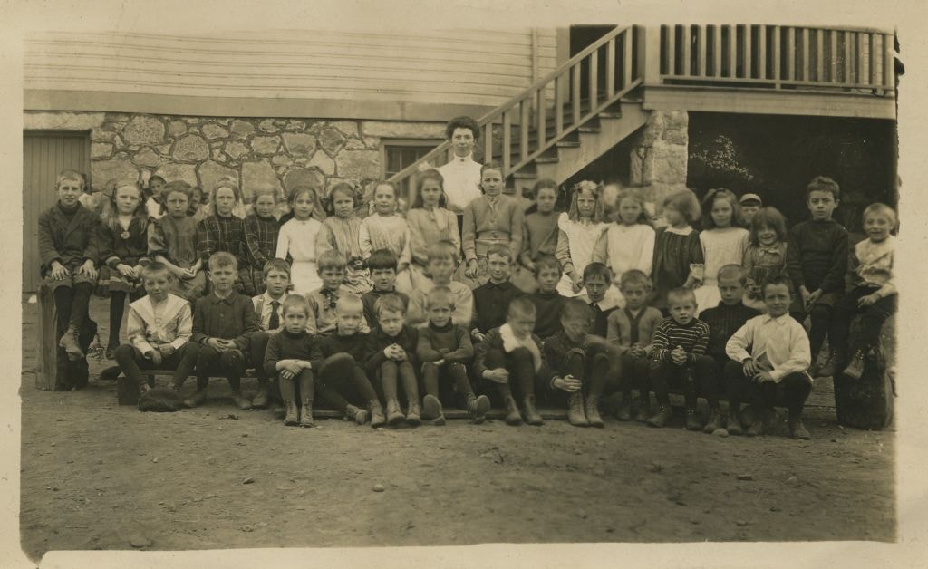
- Photographic postcard of Division III at West Burnaby School (later renamed Kingsway West school). There are twenty-two boys and fifteen girls seated in three rows, with their teacher, Miss Annie Forrest standing in the centre at the back. John Rumble is sitting in the front row, wearing a "Peter P…
- Repository
- Burnaby Village Museum
- Collection/Fonds
- Burnaby Village Museum Photograph collection
- Description Level
- Item
- Physical Description
- 1 photograph : sepia postcard ; 7.5 x 13 cm
- Material Details
- Printed by photographer on recto of photograph: "Div. III West Burnaby School. Sept 21. 1910 / Barrowclough Cards Vancouver BC".
- Scope and Content
- Photographic postcard of Division III at West Burnaby School (later renamed Kingsway West school). There are twenty-two boys and fifteen girls seated in three rows, with their teacher, Miss Annie Forrest standing in the centre at the back. John Rumble is sitting in the front row, wearing a "Peter Pan collar."
- Subjects
- Occupations - Teachers
- Geographic Access
- Kingsway
- Street Address
- 4800 Kingsway
- Accession Code
- BV999.2.39
- Access Restriction
- No restrictions
- Reproduction Restriction
- May be restricted by third party rights
- Date
- [September 21, 1910]
- Media Type
- Photograph
- Historic Neighbourhood
- Central Park (Historic Neighbourhood)
- Planning Study Area
- Maywood Area
- Related Material
- For additional copies of photographs of this group, see BV994.21.2 and BV999.2.40.
- Scan Resolution
- 600
- Scan Date
- 08-Jun-09
- Scale
- 100
- Photographer
- Barrowclough, George Alfred
- Notes
- Title based on contents of photograph.
- Additional copies of photographs of this group are held in the collection as BV994.2.2 and BV999.2.40.
Images
![Division III at West Burnaby School, [September 21, 1910] thumbnail](/media/hpo/_Data/_BVM_Images/1990/199900020039.jpg)

Division III at West Burnaby School
https://search.heritageburnaby.ca/link/museumdescription1352
- Repository
- Burnaby Village Museum
- Date
- September 21, 1910
- Collection/Fonds
- Burnaby Village Museum Photograph collection
- Description Level
- Item
- Physical Description
- 1 photograph : b&w postcard ; 7.5 x 13 cm
- Scope and Content
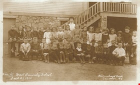
- Photographic postcard of Division III at West Burnaby School (later known as Kingsway West school). There are twenty-two boys and fifteen girls seated in three rows, with their teacher, Miss Annie Forrest standing in the centre at the back. John Rumble is sitting in the front row, wearing a "Peter …
- Repository
- Burnaby Village Museum
- Collection/Fonds
- Burnaby Village Museum Photograph collection
- Description Level
- Item
- Physical Description
- 1 photograph : b&w postcard ; 7.5 x 13 cm
- Scope and Content
- Photographic postcard of Division III at West Burnaby School (later known as Kingsway West school). There are twenty-two boys and fifteen girls seated in three rows, with their teacher, Miss Annie Forrest standing in the centre at the back. John Rumble is sitting in the front row, wearing a "Peter Pan collar."
- Subjects
- Occupations - Teachers
- Geographic Access
- Kingsway
- Street Address
- 4800 Kingsway
- Accession Code
- BV999.2.40
- Access Restriction
- No restrictions
- Reproduction Restriction
- May be restricted by third party rights
- Date
- September 21, 1910
- Media Type
- Photograph
- Historic Neighbourhood
- Central Park (Historic Neighbourhood)
- Planning Study Area
- Maywood Area
- Related Material
- For another photograph of Division III at West Burnaby School / Kingsway West School, see BV999.2.39
- Scan Resolution
- 600
- Scan Date
- 08-Jun-09
- Scale
- 100
- Photographer
- Barrowclough, George Alfred
- Notes
- Title based on contents of photograph
- Additional copies of photographs of this group are held in the collection as BV994.2.2 and BV999.2.39.
Images
Division III West Burnaby School
https://search.heritageburnaby.ca/link/museumdescription2662
- Repository
- Burnaby Village Museum
- Date
- September 21, 1910 (date of original)
- Collection/Fonds
- Burnaby Village Museum Photograph collection
- Description Level
- Item
- Physical Description
- 1 photocopy : sepia laser print ; 14 x 23.5 cm
- Scope and Content
- Photograph of Division III at West Burnaby School (later renamed Kingsway West school). There are twenty-two boys and fifteen girls seated in three rows, with their teacher, Miss Annie Forrest standing in the centre at the back. John Rumble is sitting in the front row, wearing a "Peter Pan collar."
- Repository
- Burnaby Village Museum
- Collection/Fonds
- Burnaby Village Museum Photograph collection
- Description Level
- Item
- Physical Description
- 1 photocopy : sepia laser print ; 14 x 23.5 cm
- Scope and Content
- Photograph of Division III at West Burnaby School (later renamed Kingsway West school). There are twenty-two boys and fifteen girls seated in three rows, with their teacher, Miss Annie Forrest standing in the centre at the back. John Rumble is sitting in the front row, wearing a "Peter Pan collar."
- Subjects
- Occupations - Teachers
- Geographic Access
- Kingsway
- Street Address
- 4800 Kingsway
- Accession Code
- BV004.115.37
- Access Restriction
- No restrictions
- Date
- September 21, 1910 (date of original)
- Media Type
- Photograph
- Historic Neighbourhood
- Central Park (Historic Neighbourhood)
- Planning Study Area
- Maywood Area
- Photographer
- Barrowclough, George Alfred
- Notes
- Item no. BV999.2.39 is the original postcard and item no. BV999.2.40 was taken on the same day of the same people
Images
