Narrow Results By
Subject
- Aerial Photographs 2
- Animals 1
- Animals - Birds 1
- Animals - Dogs 3
- Buildings 1
- Buildings - Civic 1
- Buildings - Civic - Libraries 4
- Buildings - Commercial 4
- Buildings - Commercial - Cinemas 1
- Buildings - Commercial - Drive-In Theatres 1
- Buildings - Commercial - Hotels and Motels 2
- Buildings - Commercial - Malls 4
Land Use Study - Maywood Area
https://search.heritageburnaby.ca/link/archivedescription31467
- Repository
- City of Burnaby Archives
- Date
- 1964
- Collection/Fonds
- Planning Department fonds
- Description Level
- File
- Physical Description
- Textual record
- Repository
- City of Burnaby Archives
- Date
- 1964
- Collection/Fonds
- Planning Department fonds
- Physical Description
- Textual record
- Description Level
- File
- Record No.
- 34478
- Accession Number
- 2003-20
- Media Type
- Textual Record
Maywood Area Land Use Study
https://search.heritageburnaby.ca/link/archivedescription5988
- Repository
- City of Burnaby Archives
- Date
- 1964
- Collection/Fonds
- Planning Department fonds
- Description Level
- Item
- Physical Description
- Textual record
- Repository
- City of Burnaby Archives
- Date
- 1964
- Collection/Fonds
- Planning Department fonds
- Physical Description
- Textual record
- Description Level
- Item
- Record No.
- 8939
- Accession Number
- 2001-02
- Media Type
- Textual Record
Maywood Area Road Improvements
https://search.heritageburnaby.ca/link/councilreport35545
- Repository
- City of Burnaby Archives
- Report ID
- 31443
- Meeting Date
- 9-May-1966
- Format
- Council - Committee Report
- Collection/Fonds
- City Council and Office of the City Clerk fonds
- Repository
- City of Burnaby Archives
- Report ID
- 31443
- Meeting Date
- 9-May-1966
- Format
- Council - Committee Report
- Collection/Fonds
- City Council and Office of the City Clerk fonds
Documents
Maywood Area Road Improvements
https://search.heritageburnaby.ca/link/councilreport35580
- Repository
- City of Burnaby Archives
- Report ID
- 31399
- Meeting Date
- 25-Apr-1966
- Format
- Council - Manager's Report
- Manager's Report No.
- 25
- Item No.
- 9
- Collection/Fonds
- City Council and Office of the City Clerk fonds
- Repository
- City of Burnaby Archives
- Report ID
- 31399
- Meeting Date
- 25-Apr-1966
- Format
- Council - Manager's Report
- Manager's Report No.
- 25
- Item No.
- 9
- Collection/Fonds
- City Council and Office of the City Clerk fonds
Documents
Maywood Area Road Improvements
https://search.heritageburnaby.ca/link/councilreport35693
- Repository
- City of Burnaby Archives
- Report ID
- 31290
- Meeting Date
- 14-Mar-1966
- Format
- Council - Manager's Report
- Manager's Report No.
- 15
- Item No.
- 8
- Collection/Fonds
- City Council and Office of the City Clerk fonds
- Repository
- City of Burnaby Archives
- Report ID
- 31290
- Meeting Date
- 14-Mar-1966
- Format
- Council - Manager's Report
- Manager's Report No.
- 15
- Item No.
- 8
- Collection/Fonds
- City Council and Office of the City Clerk fonds
Documents
Miscellaneous Rezoning Applications in the Maywood Area
https://search.heritageburnaby.ca/link/councilreport35684
- Repository
- City of Burnaby Archives
- Report ID
- 31289
- Meeting Date
- 14-Mar-1966
- Format
- Council - Manager's Report
- Manager's Report No.
- 15
- Item No.
- 7
- Collection/Fonds
- City Council and Office of the City Clerk fonds
- Repository
- City of Burnaby Archives
- Report ID
- 31289
- Meeting Date
- 14-Mar-1966
- Format
- Council - Manager's Report
- Manager's Report No.
- 15
- Item No.
- 7
- Collection/Fonds
- City Council and Office of the City Clerk fonds
Documents

Maywood Elementary School
https://search.heritageburnaby.ca/link/landmark812
- Repository
- Burnaby Heritage Planning
- Geographic Access
- Imperial Street
- Associated Dates
- 1962
- Heritage Value
- Located between Nelson and Suncrest Schools, Maywood Elementary School was built in 1962 and helped eased the increasing enrolments at these other schools. Like other schools of this period, Maywood was built on one level with no basement and no high stairs. The classrooms were built in a line which could be easily added to as required. Additions to the original structure were completed in 1964, 1966, 1967, 1971, 1972. Fires at the school in 1979 and 1989 caused extensive damage and required partial reconstruction of the building.
- Historic Neighbourhood
- Central Park (Historic Neighbourhood)
- Planning Study Area
- Maywood Area
- Street Address
- 4567 Imperial Street
- Street View URL
- Google Maps Street View
Images


Maywood Neighbourhood
https://search.heritageburnaby.ca/link/landmark801
- Repository
- Burnaby Heritage Planning
- Associated Dates
- 1955-2008
- Heritage Value
- Burnaby's Maywood Neighbourhood consists of the Metrotown Town Centre - one of four Town Centres in the City. Metrotown is one of the region's most developed and fastest growing centres. It is served by the first SkyTrain line developed in the mid-1980s and anchored by B.C.'s largest shopping and entertainment complex. As an older centre that has progressively added new developments over the years, Metrotown offers a range of housing types and tenures from three-storey walk-up apartments to modern residential towers.
- Historic Neighbourhood
- Central Park (Historic Neighbourhood)
- Planning Study Area
- Maywood Area
Images


Swangard Stadium
https://search.heritageburnaby.ca/link/landmark818
- Repository
- Burnaby Heritage Planning
- Geographic Access
- Imperial Street
- Associated Dates
- 1969
- Heritage Value
- On 26 April 1969 Swangard Stadium held its official opening. Named after Vancouver Sun former Managing Editor, Erwin Swangard, the stadium was funded entirely from private donations and civic and provincial grants.
- Historic Neighbourhood
- Central Park (Historic Neighbourhood)
- Planning Study Area
- Maywood Area
- Street Address
- 3883 Imperial Street
Images

![24-hour relay at Swangard Stadium, [1999] thumbnail](/media/hpo/_Data/_Archives_Images/_Unrestricted/535/535-3231.jpg?width=280)
24-hour relay at Swangard Stadium
https://search.heritageburnaby.ca/link/archivedescription98153
- Repository
- City of Burnaby Archives
- Date
- [1999]
- Collection/Fonds
- Burnaby NewsLeader photograph collection
- Description Level
- Item
- Physical Description
- 1 photograph (tiff) : col.
- Scope and Content
- Photograph of a runner wearing a cow-spotted costume during a 24-hour relay race at Swangard Stadium. Other runners and participants with a banner are on the track behind the runner and many people are sitting in the stands in the background.
- Repository
- City of Burnaby Archives
- Date
- [1999]
- Collection/Fonds
- Burnaby NewsLeader photograph collection
- Physical Description
- 1 photograph (tiff) : col.
- Description Level
- Item
- Record No.
- 535-3231
- Access Restriction
- No restrictions
- Reproduction Restriction
- No restrictions
- Accession Number
- 2018-12
- Scope and Content
- Photograph of a runner wearing a cow-spotted costume during a 24-hour relay race at Swangard Stadium. Other runners and participants with a banner are on the track behind the runner and many people are sitting in the stands in the background.
- Names
- Swangard Stadium
- Media Type
- Photograph
- Notes
- Title based on contents of photograph
- Collected by editorial for use in a June 1999 issue of the Burnaby NewsLeader
- Geographic Access
- Central Park
- Imperial Street
- Street Address
- 3883 Imperial Street
- Historic Neighbourhood
- Central Park (Historic Neighbourhood)
- Planning Study Area
- Maywood Area
Images
![24-hour relay at Swangard Stadium, [1999] thumbnail](/media/hpo/_Data/_Archives_Images/_Unrestricted/535/535-3231.jpg)
4322-4342 Victory St
https://search.heritageburnaby.ca/link/archivedescription93770
- Repository
- City of Burnaby Archives
- Date
- August 1992
- Collection/Fonds
- Grover, Elliott & Co. Ltd. fonds
- Description Level
- File
- Physical Description
- 56 photographs : col. negatives ; 35 mm
- Scope and Content
- Photographs of the houses located between 4322-4342 Victory Street - addresses that no longer exist. The Skytrain Expo line is visible in the background of some photographs.
- Repository
- City of Burnaby Archives
- Date
- August 1992
- Collection/Fonds
- Grover, Elliott & Co. Ltd. fonds
- Physical Description
- 56 photographs : col. negatives ; 35 mm
- Description Level
- File
- Record No.
- 622-054
- Access Restriction
- No restrictions
- Reproduction Restriction
- No restrictions
- Accession Number
- 2017-39
- Scope and Content
- Photographs of the houses located between 4322-4342 Victory Street - addresses that no longer exist. The Skytrain Expo line is visible in the background of some photographs.
- Media Type
- Photograph
- Notes
- Transcribed title
- Title transcribed from envelope photographs were originally housed in
- File no. 92-304-B
- Geographic Access
- Victory Street
- Historic Neighbourhood
- Alta Vista (Historic Neighbourhood)
- Planning Study Area
- Maywood Area
4390 Grange Street, Bby [sic]
https://search.heritageburnaby.ca/link/archivedescription94319
- Repository
- City of Burnaby Archives
- Date
- September 1994
- Collection/Fonds
- Grover, Elliott & Co. Ltd. fonds
- Description Level
- File
- Physical Description
- 22 photographs : col. negatives ; 35 mm
- Scope and Content
- Photographs of the exterior of a high-rise apartment complex located at 4390 Grange Street.
- Repository
- City of Burnaby Archives
- Date
- September 1994
- Collection/Fonds
- Grover, Elliott & Co. Ltd. fonds
- Physical Description
- 22 photographs : col. negatives ; 35 mm
- Description Level
- File
- Record No.
- 622-104
- Access Restriction
- No restrictions
- Reproduction Restriction
- No restrictions
- Accession Number
- 2017-39
- Scope and Content
- Photographs of the exterior of a high-rise apartment complex located at 4390 Grange Street.
- Subjects
- Buildings - Residential - Apartments
- Media Type
- Photograph
- Notes
- Transcribed title
- Title transcribed from envelope photographs were originally housed in
- File no. 94-353-B
- Geographic Access
- Grange Street
- Street Address
- 4390 Grange Street
- Historic Neighbourhood
- Central Park (Historic Neighbourhood)
- Planning Study Area
- Maywood Area
5899 Wilson Ave.
https://search.heritageburnaby.ca/link/archivedescription94314
- Repository
- City of Burnaby Archives
- Date
- June 1994
- Collection/Fonds
- Grover, Elliott & Co. Ltd. fonds
- Description Level
- File
- Physical Description
- 20 photographs : col. negatives ; 35 mm
- Scope and Content
- Photographs of an undeveloped property located at 5899 Wilson Avenue and a tower under construction near the corner of Wilson Avenue and Kingsway.
- Repository
- City of Burnaby Archives
- Date
- June 1994
- Collection/Fonds
- Grover, Elliott & Co. Ltd. fonds
- Physical Description
- 20 photographs : col. negatives ; 35 mm
- Description Level
- File
- Record No.
- 622-099
- Access Restriction
- No restrictions
- Reproduction Restriction
- No restrictions
- Accession Number
- 2017-39
- Scope and Content
- Photographs of an undeveloped property located at 5899 Wilson Avenue and a tower under construction near the corner of Wilson Avenue and Kingsway.
- Media Type
- Photograph
- Notes
- Transcribed title
- Title transcribed from envelope photographs were originally housed in
- File no. 94-247-B
- Geographic Access
- Wilson Avenue
- Street Address
- 5899 Wilson Avenue
- Historic Neighbourhood
- Central Park (Historic Neighbourhood)
- Planning Study Area
- Maywood Area
5899 Wilson Ave
https://search.heritageburnaby.ca/link/archivedescription94320
- Repository
- City of Burnaby Archives
- Date
- October 1994
- Collection/Fonds
- Grover, Elliott & Co. Ltd. fonds
- Description Level
- File
- Physical Description
- 25 photographs : col. negatives ; 35 mm
- Scope and Content
- Photographs of a high-rise tower under construction at 5899 Wilson Avenue.
- Repository
- City of Burnaby Archives
- Date
- October 1994
- Collection/Fonds
- Grover, Elliott & Co. Ltd. fonds
- Physical Description
- 25 photographs : col. negatives ; 35 mm
- Description Level
- File
- Record No.
- 622-105
- Access Restriction
- No restrictions
- Reproduction Restriction
- No restrictions
- Accession Number
- 2017-39
- Scope and Content
- Photographs of a high-rise tower under construction at 5899 Wilson Avenue.
- Subjects
- Buildings - Residential - Apartments
- Media Type
- Photograph
- Notes
- Transcribed title
- Title transcribed from envelope photographs were originally housed in
- File no. 94-365-B
- Photographer identified as "J.C."
- Geographic Access
- Wilson Avenue
- Street Address
- 5899 Wilson Avenue
- Historic Neighbourhood
- Central Park (Historic Neighbourhood)
- Planning Study Area
- Maywood Area
6451 Telford Ave
https://search.heritageburnaby.ca/link/archivedescription94300
- Repository
- City of Burnaby Archives
- Date
- January 1994
- Collection/Fonds
- Grover, Elliott & Co. Ltd. fonds
- Description Level
- File
- Physical Description
- 22 photographs : col. negatives ; 35 mm
- Scope and Content
- Photographs of a self-storage business located at 6451 Telford Avenue - an address that no longer exists.
- Repository
- City of Burnaby Archives
- Date
- January 1994
- Collection/Fonds
- Grover, Elliott & Co. Ltd. fonds
- Physical Description
- 22 photographs : col. negatives ; 35 mm
- Description Level
- File
- Record No.
- 622-085
- Access Restriction
- No restrictions
- Reproduction Restriction
- No restrictions
- Accession Number
- 2017-39
- Scope and Content
- Photographs of a self-storage business located at 6451 Telford Avenue - an address that no longer exists.
- Subjects
- Buildings - Commercial
- Media Type
- Photograph
- Notes
- Transcribed title
- Title transcribed from envelope photographs were originally housed in
- File no. 94-011-B
- Photographer identified as "K.H."
- Geographic Access
- Telford Avenue
- Historic Neighbourhood
- Central Park (Historic Neighbourhood)
- Planning Study Area
- Maywood Area
6622 Willingdon Ave
https://search.heritageburnaby.ca/link/archivedescription93750
- Repository
- City of Burnaby Archives
- Date
- July 18, 1990
- Collection/Fonds
- Grover, Elliott & Co. Ltd. fonds
- Description Level
- File
- Physical Description
- 20 photographs : col. negatives ; 35 mm
- Scope and Content
- Photographs of the exterior of a three-storey apartment complex located at 6622 Willingdon Avenue and the surrounding area.
- Repository
- City of Burnaby Archives
- Date
- July 18, 1990
- Collection/Fonds
- Grover, Elliott & Co. Ltd. fonds
- Physical Description
- 20 photographs : col. negatives ; 35 mm
- Description Level
- File
- Record No.
- 622-035
- Access Restriction
- No restrictions
- Reproduction Restriction
- No restrictions
- Accession Number
- 2017-39
- Scope and Content
- Photographs of the exterior of a three-storey apartment complex located at 6622 Willingdon Avenue and the surrounding area.
- Media Type
- Photograph
- Notes
- Transcribed title
- Title transcribed from envelope photographs were originally housed in
- File no. 90V-002-B
- Geographic Access
- Willingdon Avenue
- Street Address
- 6622 Willingdon Avenue
- Historic Neighbourhood
- Central Park (Historic Neighbourhood)
- Planning Study Area
- Maywood Area
7641-7651 Royal Oak Ave
https://search.heritageburnaby.ca/link/archivedescription93769
- Repository
- City of Burnaby Archives
- Date
- July 30, 1992
- Collection/Fonds
- Grover, Elliott & Co. Ltd. fonds
- Description Level
- File
- Physical Description
- 25 photographs : col. negatives ; 35 mm
- Scope and Content
- Photographs of the commercial properties located between 7641 and 7651 Royal Oak Avenue. Stores visible in the photographs include: Buy Low Foods, Mega Movies, and Chevron service station.
- Repository
- City of Burnaby Archives
- Date
- July 30, 1992
- Collection/Fonds
- Grover, Elliott & Co. Ltd. fonds
- Physical Description
- 25 photographs : col. negatives ; 35 mm
- Description Level
- File
- Record No.
- 622-053
- Access Restriction
- No restrictions
- Reproduction Restriction
- No restrictions
- Accession Number
- 2017-39
- Scope and Content
- Photographs of the commercial properties located between 7641 and 7651 Royal Oak Avenue. Stores visible in the photographs include: Buy Low Foods, Mega Movies, and Chevron service station.
- Subjects
- Buildings - Commercial
- Buildings - Commercial - Service Stations
- Buildings - Commercial - Stores
- Geographic Features - Roads
- Media Type
- Photograph
- Photographer
- Young, Richard
- Notes
- Transcribed title
- Title transcribed from envelope photographs were originally housed in
- File no. 92-287-B
- Geographic Access
- Royal Oak Avenue
- Historic Neighbourhood
- Alta Vista (Historic Neighbourhood)
- Planning Study Area
- Maywood Area

Annie Ellis in Burnaby Players costume
https://search.heritageburnaby.ca/link/archivedescription37772
- Repository
- City of Burnaby Archives
- Date
- 1963 (date of original), copied 1991
- Collection/Fonds
- Burnaby Historical Society fonds
- Description Level
- Item
- Physical Description
- 1 photograph : b&w ; 2.6 x 4.0 cm print on contact sheet 20.3 x 26.2 cm
- Scope and Content
- Photograph of Annie Ellis, in a Burnaby Players costume, at the back of 6113 Silver Avenue, the Ellis family home.
- Repository
- City of Burnaby Archives
- Date
- 1963 (date of original), copied 1991
- Collection/Fonds
- Burnaby Historical Society fonds
- Subseries
- Burnaby Image Bank subseries
- Physical Description
- 1 photograph : b&w ; 2.6 x 4.0 cm print on contact sheet 20.3 x 26.2 cm
- Description Level
- Item
- Record No.
- 370-360
- Access Restriction
- No restrictions
- Reproduction Restriction
- No restrictions
- Accession Number
- BHS1999-03
- Scope and Content
- Photograph of Annie Ellis, in a Burnaby Players costume, at the back of 6113 Silver Avenue, the Ellis family home.
- Subjects
- Occupations - Actors
- Clothing - Costumes
- Media Type
- Photograph
- Notes
- Title based on contents of photograph
- 1 b&w copy negative accompanying
- Negative has a pink cast
- Geographic Access
- Silver Avenue
- Street Address
- 6113 Silver Avenue
- Historic Neighbourhood
- Central Park (Historic Neighbourhood)
- Planning Study Area
- Maywood Area
Images

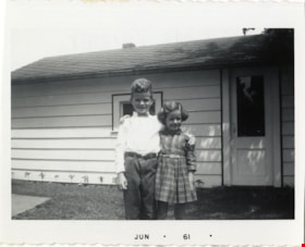
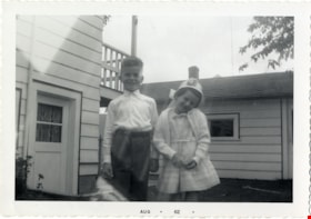
Bob and Colleen Rogers
https://search.heritageburnaby.ca/link/museumdescription21392
- Repository
- Burnaby Village Museum
- Date
- Jun. 1961
- Collection/Fonds
- Robert Rogers fonds
- Description Level
- Item
- Physical Description
- 1 photograph : b&w ; 8.5 x 6.5 cm
- Scope and Content
- Photograph of Robert "Bob" Rogers and sister Collen Rogers standing in the backyard of their house at 6458 Willingdon Avenue.
- Repository
- Burnaby Village Museum
- Collection/Fonds
- Robert Rogers fonds
- Description Level
- Item
- Physical Description
- 1 photograph : b&w ; 8.5 x 6.5 cm
- Scope and Content
- Photograph of Robert "Bob" Rogers and sister Collen Rogers standing in the backyard of their house at 6458 Willingdon Avenue.
- Geographic Access
- Willingdon Avenue
- Street Address
- 6458 Willingdon Avenue
- Accession Code
- BV024.8.6
- Access Restriction
- No restrictions
- Reproduction Restriction
- May be restricted by third party rights
- Date
- Jun. 1961
- Media Type
- Photograph
- Historic Neighbourhood
- Central Park (Historic Neighbourhood)
- Planning Study Area
- Maywood Area
- Scan Resolution
- 600
- Scan Date
- 2024-03-26
- Notes
- Title based on contents of photograph
- Date stamp on recto of photograph reads: "JUN_61"
- Note in black ink on verso of photograph reads:"BOB ROGERS & SISTER / COLLEEN ROGERS / TAKEN IN BACK YARD OF / 6458 WILLINGDON AVENUE"
Images
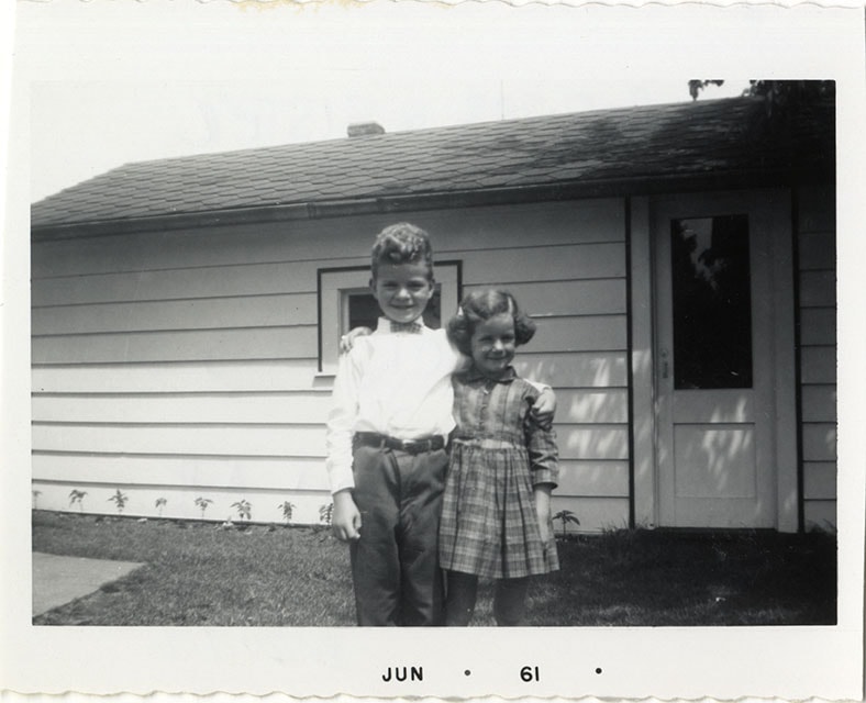
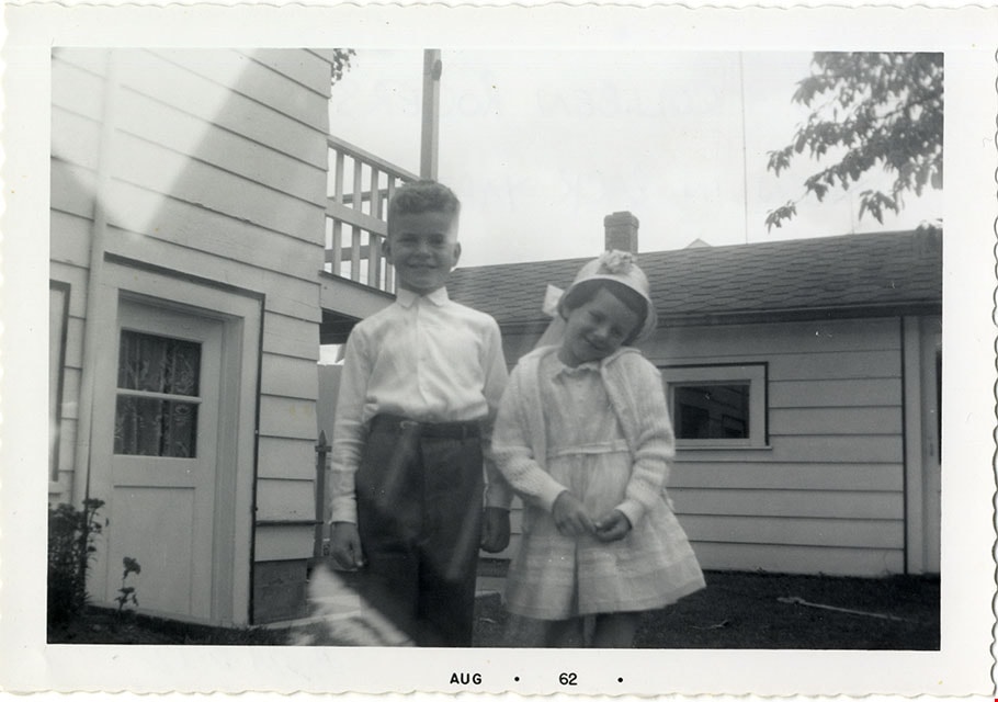
Bob and Colleen Rogers
https://search.heritageburnaby.ca/link/museumdescription21398
- Repository
- Burnaby Village Museum
- Collection/Fonds
- Robert Rogers fonds
- Description Level
- Item
- Physical Description
- 1 photograph : b&w ; 9 x 13 cm
- Scope and Content
- Photograph of Bob and Colleen Rogers standing in the backyard outside of their childhood family home located at 6458 Willingdon Avenue.
- Geographic Access
- Willingdon Avenue
- Street Address
- 6458 Willingdon Avenue
- Accession Code
- BV024.8.12
- Access Restriction
- No restrictions
- Reproduction Restriction
- May be restricted by third party rights
- Media Type
- Photograph
- Historic Neighbourhood
- Central Park (Historic Neighbourhood)
- Planning Study Area
- Maywood Area
- Scan Resolution
- 600
- Scan Date
- 2024-03-26
- Notes
- Title based on contents of photograph
- Note in black ink on verso of photograph reads: "BOB & COLLEEN ROGERS / TAKEN IN BACKYARD AT / 6458 WILLINGDON AVE."
Images