Narrow Results By
![Dow, Fraser and Company Limited, [1915] thumbnail](/media/hpo/_Data/_BVM_Images/1977/1977_0077_0001_001.jpg?width=280)
Dow, Fraser and Company Limited
https://search.heritageburnaby.ca/link/museumdescription551
- Repository
- Burnaby Village Museum
- Date
- [1915]
- Collection/Fonds
- Burnaby Village Museum Photograph collection
- Description Level
- Item
- Physical Description
- 1 photograph : sepia ; 16.5 x 21.5 cm photogravure
- Scope and Content
- Photograph of Mr. Eric Warrington Howard Bennett standing on the doorway to a store with large signs for a branch of Dow, Fraser & Co. Limited for real estate, loans, and fire insurance. The trust company is advertised on the sign as having been established in 1900. There is another store in the bu…
- Repository
- Burnaby Village Museum
- Collection/Fonds
- Burnaby Village Museum Photograph collection
- Description Level
- Item
- Physical Description
- 1 photograph : sepia ; 16.5 x 21.5 cm photogravure
- Scope and Content
- Photograph of Mr. Eric Warrington Howard Bennett standing on the doorway to a store with large signs for a branch of Dow, Fraser & Co. Limited for real estate, loans, and fire insurance. The trust company is advertised on the sign as having been established in 1900. There is another store in the building that is unidentified. Eric Warrington Howard Bennett was the branch manager of the Dow, Fraser company which started in Burnaby circa 1915. The store was located on the corner of McKay Avenue and the BC Electric Railway tracks. Later, a top storey was added to the building. An annotation on the back of the photograph reads: "Burnaby Branch Office. / E.W.H. Bennett / Manager."
- Geographic Access
- McKay Avenue
- Accession Code
- HV977.77.1
- Access Restriction
- No restrictions
- Reproduction Restriction
- No known restrictions
- Date
- [1915]
- Media Type
- Photograph
- Historic Neighbourhood
- Central Park (Historic Neighbourhood)
- Planning Study Area
- Maywood Area
- Scan Resolution
- 600
- Scan Date
- 2023-07-11
- Notes
- Title based on contents of photograph
Images
![Dow, Fraser and Company Limited, [1915] thumbnail](/media/hpo/_Data/_BVM_Images/1977/1977_0077_0001_001.jpg)
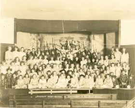
Kingsway West School in "Goldenhair & the Three Bears"
https://search.heritageburnaby.ca/link/museumdescription1056
- Repository
- Burnaby Village Museum
- Date
- [1923]
- Collection/Fonds
- Burnaby Village Museum Photograph collection
- Description Level
- Item
- Physical Description
- 1 photograph : sepia ; 19.4 x 24.2 cm
- Scope and Content
- Photograph of the cast of the Kingsway West School's production of "Goldenhair and the Three Bears." The costumed students, varying in grades and ages, are posed in front of a painted backdrop on a stage. Inscribed on the negative and printed on the photograph, bottom front: "Kingsway West School…
- Repository
- Burnaby Village Museum
- Collection/Fonds
- Burnaby Village Museum Photograph collection
- Description Level
- Item
- Physical Description
- 1 photograph : sepia ; 19.4 x 24.2 cm
- Scope and Content
- Photograph of the cast of the Kingsway West School's production of "Goldenhair and the Three Bears." The costumed students, varying in grades and ages, are posed in front of a painted backdrop on a stage. Inscribed on the negative and printed on the photograph, bottom front: "Kingsway West School in 'Goldenhair & the Three Bears.'" and "Stuart Thomson / Vancouver / B.C." In a letter written to the museum in 1973, the donor states, "This Kingsway West School concert was held fifty odd years ago, I believe in the then 'Phillips Hall' at the corner of McKay Avenue and the old interurban line."
- Subjects
- Performances - Concerts
- Names
- Kingsway West School
- Geographic Access
- McKay Avenue
- Street Address
- 6285 McKay Avenue
- Accession Code
- HV973.158.1
- Access Restriction
- No restrictions
- Reproduction Restriction
- No known restrictions
- Date
- [1923]
- Media Type
- Photograph
- Historic Neighbourhood
- Central Park (Historic Neighbourhood)
- Planning Study Area
- Maywood Area
- Scan Resolution
- 600
- Scan Date
- 2023-06-06
- Photographer
- Thomson, Stuart
- Notes
- Title based on caption of photograph
Images


Kingsway West School site
https://search.heritageburnaby.ca/link/museumdescription11122
- Repository
- Burnaby Village Museum
- Date
- March 16, 1915
- Collection/Fonds
- Ronald G. Scobbie collection
- Description Level
- Item
- Physical Description
- 1 survey plan : blueprint on paper with pencil notations ; 56 x 54 cm
- Scope and Content
- Survey plan of "Kingsway West School Site" "Burnaby Municipality" "being Lot 1, D.L.32, Lot 1 of Lot 21, Portion of Lot 21 and Portion of Lot 20, of subdivision of D.L.152, 153 & Portion of Lot 151, Group 1, New Westminster District". Notations in pencil extend along the south boundary line of Dist…
- Repository
- Burnaby Village Museum
- Collection/Fonds
- Ronald G. Scobbie collection
- Description Level
- Item
- Physical Description
- 1 survey plan : blueprint on paper with pencil notations ; 56 x 54 cm
- Material Details
- Scale: 40 feet = 1 inch
- Scope and Content
- Survey plan of "Kingsway West School Site" "Burnaby Municipality" "being Lot 1, D.L.32, Lot 1 of Lot 21, Portion of Lot 21 and Portion of Lot 20, of subdivision of D.L.152, 153 & Portion of Lot 151, Group 1, New Westminster District". Notations in pencil extend along the south boundary line of District Lot 32.
- Creator
- McGugan, Donald Johnston
- Subjects
- Buildings - Schools
- Names
- Kingsway West School
- Responsibility
- Burnett and McGugan B.C. Land Surveyors, New Westminster
- Geographic Access
- Kingsway
- Sussex Avenue
- Accession Code
- BV003.83.2
- Access Restriction
- No restrictions
- Reproduction Restriction
- No known restrictions
- Date
- March 16, 1915
- Media Type
- Cartographic Material
- Historic Neighbourhood
- Central Park (Historic Neighbourhood)
- Planning Study Area
- Maywood Area
- Scan Resolution
- 440
- Scan Date
- 22-Dec-2020
- Scale
- 100
- Notes
- Transcribed title
- Oath in bottom left corner reads: "I, D.J. McGugan...did personally superintend the survey ..." "...completed on the 16th day of March 1915", signed "D.J. McGugan" and is notarized on March 19th, 1915 by "S.F. Frank" with a seal
- handwritten on back, "1753";
- See also BV003.83.9 - duplicate blueprint plan without annotations
- See also BV003.83.3 for original plan on waxed linen
Zoomable Images

Kingsway West School site
https://search.heritageburnaby.ca/link/museumdescription11123
- Repository
- Burnaby Village Museum
- Date
- March 16, 1915
- Collection/Fonds
- Ronald G. Scobbie collection
- Description Level
- Item
- Physical Description
- 1 survey plan : blackline print on waxed linen ; 59 x 59 cm
- Scope and Content
- Survey plan titled “Kingsway West School Site" "Burnaby Municipality" / being Lot 1, D.L.32, Lot 1 of Lot 21, Portion of / Lot 21 and Portion of Lot 20, of subdivision / of D.L.152, 153 & Portion of Lot 151, Group 1 / New Westminster District".
- Repository
- Burnaby Village Museum
- Collection/Fonds
- Ronald G. Scobbie collection
- Description Level
- Item
- Physical Description
- 1 survey plan : blackline print on waxed linen ; 59 x 59 cm
- Material Details
- Scale [1:480]
- Scope and Content
- Survey plan titled “Kingsway West School Site" "Burnaby Municipality" / being Lot 1, D.L.32, Lot 1 of Lot 21, Portion of / Lot 21 and Portion of Lot 20, of subdivision / of D.L.152, 153 & Portion of Lot 151, Group 1 / New Westminster District".
- Subjects
- Buildings - Schools
- Names
- Kingsway West School
- Geographic Access
- Kingsway
- Sussex Avenue
- Accession Code
- BV003.83.3
- Access Restriction
- No restrictions
- Reproduction Restriction
- No known restrictions
- Date
- March 16, 1915
- Media Type
- Cartographic Material
- Historic Neighbourhood
- Central Park (Historic Neighbourhood)
- Planning Study Area
- Maywood Area
- Notes
- Transcribed title
- Scale on plan reads" 40 feet = 1 inch"
- Oath on plan reads: "I, D.J. McGugan...did personally superintend the survey ..." "...completed on the 16th day of March 1915", signed "D.J. McGugan", and notarized by "S.F. Mark
- See also BV0003.83.2 for digitized blueprint
Kingsway West School site
https://search.heritageburnaby.ca/link/museumdescription11130
- Repository
- Burnaby Village Museum
- Date
- March 16, 1915
- Collection/Fonds
- Ronald G. Scobbie collection
- Description Level
- Item
- Physical Description
- 1 survey plan : blueprint on paper ; 56 x 54 cm
- Scope and Content
- Survey plan of "Kingsway West School Site" "Burnaby Municipality" "being Lot 1, D.L.32, Lot 1 of Lot 21, Portion of Lot 21 and Portion of Lot 20, of subdivision of D.L.152, 153 & Portion of Lot 151, Group 1, New Westminster District".
- Repository
- Burnaby Village Museum
- Collection/Fonds
- Ronald G. Scobbie collection
- Description Level
- Item
- Physical Description
- 1 survey plan : blueprint on paper ; 56 x 54 cm
- Material Details
- Scale: [1:480]
- Scope and Content
- Survey plan of "Kingsway West School Site" "Burnaby Municipality" "being Lot 1, D.L.32, Lot 1 of Lot 21, Portion of Lot 21 and Portion of Lot 20, of subdivision of D.L.152, 153 & Portion of Lot 151, Group 1, New Westminster District".
- Creator
- McGugan, Donald Johnston
- Subjects
- Buildings - Schools
- Names
- Kingsway West School
- Geographic Access
- Kingsway
- Sussex Avenue
- Accession Code
- BV003.83.9
- Access Restriction
- No restrictions
- Reproduction Restriction
- No known restrictions
- Date
- March 16, 1915
- Media Type
- Cartographic Material
- Historic Neighbourhood
- Central Park (Historic Neighbourhood)
- Planning Study Area
- Maywood Area
- Notes
- Title based on contents of plan
- Scale on plan reads: "40 feet = 1 inch"
- Oath in bottom left corner reads: "I, D.J. McGugan...did personally superintend the survey ..." "...completed on the 16th day of March 1915", signed "D.J. McGugan", and notarized by "S.F. Mark
- handwritten on back, "1753
- See also BV003.83.2 - duplicate plan with annotations- digitized in 2020
- See also BV003.83.3 for original plan on waxed linen
![Royal Bank of Canada, Kingsway branch, [January 1930] thumbnail](/media/hpo/_Data/_BVM_Images/2018/2018_0043_0001_001.jpg?width=280)
Royal Bank of Canada, Kingsway branch
https://search.heritageburnaby.ca/link/museumdescription9775
- Repository
- Burnaby Village Museum
- Date
- [January 1930]
- Collection/Fonds
- Burnaby Village Museum Photograph collection
- Description Level
- Item
- Physical Description
- 1 photograph : b&w ; 16.5 x 23 cm print
- Scope and Content
- Photograph of the Royal Bank of Canada branch located on Kingsway and McKay in Burnaby. Telephone visible in foreground and a post labelled "KINGSWAY" is on left foreground, at corner of street.
- Repository
- Burnaby Village Museum
- Collection/Fonds
- Burnaby Village Museum Photograph collection
- Description Level
- Item
- Physical Description
- 1 photograph : b&w ; 16.5 x 23 cm print
- Scope and Content
- Photograph of the Royal Bank of Canada branch located on Kingsway and McKay in Burnaby. Telephone visible in foreground and a post labelled "KINGSWAY" is on left foreground, at corner of street.
- Subjects
- Buildings - Commercial - Banks
- Names
- Royal Bank of Canada
- Geographic Access
- Kingsway
- McKay Avenue
- Accession Code
- BV018.43.1
- Access Restriction
- Restricted access
- Reproduction Restriction
- May be restricted by third party rights
- Date
- [January 1930]
- Media Type
- Photograph
- Historic Neighbourhood
- Central Park (Historic Neighbourhood)
- Planning Study Area
- Maywood Area
- Marlborough Area
- Scan Resolution
- 300
- Scan Date
- 10-Jan-2019
- Scale
- 96
- Notes
- Title based on contents of photograph
- Note on verso of photograph reads: "The Royal Bank of Canada Archvies 78-156/ #89"
Images
![Royal Bank of Canada, Kingsway branch, [January 1930] thumbnail](/media/hpo/_Data/_BVM_Images/2018/2018_0043_0001_001.jpg)