Narrow Results By
Subject
- Advertising Medium - Signs and Signboards 21
- Aerial Photographs 1
- Agricultural Tools and Equipment - Gardening Equipment 1
- Agriculture - Farms 2
- Agriculture - Fruit and Berries 1
- Animals - Cats 1
- Animals - Dogs 7
- Animals - Goats 1
- Animals - Horses 1
- Buildings - Agricultural 1
- Buildings - Civic - Community Centres 1
- Buildings - Civic - Fire Halls 2
Person / Organization
- Albertson, Mrs. 1
- A. MacKenzie and Company Jubilee Store 6
- Army, Navy and Air Force Veterans in Canada, Pompier Unit #314 1
- Astor Hotel 6
- Bentall, R.G. 1
- Bonsor Hall 1
- Bonsor Recreation Complex 9
- Brown, Charles B. "Charlie" 1
- Brown, Donald N. "Don" 3
- Brown, Fern 1
- Burnaby Community Council 1
- Burnaby Fire Department 2
![Royal Oak Funeral Chapel being dragged by a truck, [November] 1981 thumbnail](/media/hpo/_Data/_Archives_Images/_Unrestricted/205/222-046.jpg?width=280)
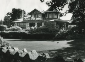
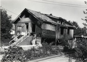
Royal Oak Funeral Chapel being dragged by a truck
https://search.heritageburnaby.ca/link/archivedescription36123
- Repository
- City of Burnaby Archives
- Date
- [November] 1981
- Collection/Fonds
- Burnaby Historical Society fonds
- Description Level
- Item
- Physical Description
- 1 photograph : b&w ; 17 x 24.5 cm
- Scope and Content
- Photograph of the Royal Oak Funeral Chapel being dragged 50 paces by a Nickel Bros. semi-trailer truck. This building is also known as 'Glenedward' and its address has been renumbered 5152 Kingsway.
- Repository
- City of Burnaby Archives
- Date
- [November] 1981
- Collection/Fonds
- Burnaby Historical Society fonds
- Subseries
- Columbian Newspaper subseries
- Physical Description
- 1 photograph : b&w ; 17 x 24.5 cm
- Description Level
- Item
- Record No.
- 222-046
- Access Restriction
- No restrictions
- Reproduction Restriction
- Reproduce for fair dealing purposes only
- Accession Number
- BHS1989-19
- Scope and Content
- Photograph of the Royal Oak Funeral Chapel being dragged 50 paces by a Nickel Bros. semi-trailer truck. This building is also known as 'Glenedward' and its address has been renumbered 5152 Kingsway.
- Names
- Royal Oak Funeral Chapel
- Media Type
- Photograph
- Photographer
- King, Basil
- Notes
- Title based on contents of photograph
- 3 b&w copy negatives accompanying
- Stamp on verso of photograph reads: Basil King Photo
- Newspaper clipping glued to verso of photograph reads: "ON THE MOVE... The old Royal Oak Funeral Home is north to make way for a commercial development on the Burnaby took a big ride Friday-- exactly 25 pace to the site.""Columbian photo by Basil King"
- Geographic Access
- Kingsway
- Street Address
- 5152 Kingsway
- Historic Neighbourhood
- Central Park (Historic Neighbourhood)
- Planning Study Area
- Marlborough Area
Images
![Royal Oak Funeral Chapel being dragged by a truck, [November] 1981 thumbnail](/media/hpo/_Data/_Archives_Images/_Unrestricted/205/222-046.jpg)
![Royal Oak Funeral Chapel being moved, [November] 1981 thumbnail](/media/hpo/_Data/_Archives_Images/_Unrestricted/205/222-047.jpg?width=280)
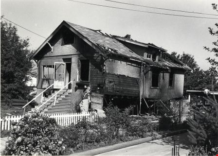
Royal Oak Funeral Chapel being moved
https://search.heritageburnaby.ca/link/archivedescription36124
- Repository
- City of Burnaby Archives
- Date
- [November] 1981
- Collection/Fonds
- Burnaby Historical Society fonds
- Description Level
- Item
- Physical Description
- 1 photograph : b&w ; 17.5 x 22.5 cm
- Scope and Content
- Photograph of a group of Burnaby residents watching from across the street as the Royal Oak Funeral Chapel is moved 25 paces This building is also known as 'Glenedward' and its address has been renumbered 5152 Kingsway.
- Repository
- City of Burnaby Archives
- Date
- [November] 1981
- Collection/Fonds
- Burnaby Historical Society fonds
- Subseries
- Columbian Newspaper subseries
- Physical Description
- 1 photograph : b&w ; 17.5 x 22.5 cm
- Description Level
- Item
- Record No.
- 222-047
- Access Restriction
- No restrictions
- Reproduction Restriction
- Reproduce for fair dealing purposes only
- Accession Number
- BHS1989-19
- Scope and Content
- Photograph of a group of Burnaby residents watching from across the street as the Royal Oak Funeral Chapel is moved 25 paces This building is also known as 'Glenedward' and its address has been renumbered 5152 Kingsway.
- Names
- Royal Oak Funeral Chapel
- Media Type
- Photograph
- Photographer
- King, Basil
- Notes
- Title based on contents of photograph
- 3 b&w copy negatives accompanying
- Stamp on verso of photograph reads: Basil King Photo
- Geographic Access
- Kingsway
- Street Address
- 5152 Kingsway
- Historic Neighbourhood
- Central Park (Historic Neighbourhood)
- Planning Study Area
- Marlborough Area
Images
![Royal Oak Funeral Chapel being moved, [November] 1981 thumbnail](/media/hpo/_Data/_Archives_Images/_Unrestricted/205/222-047.jpg)
![Royal Oak Funeral Chapel, [1980] thumbnail](/media/Hpo/_Data/_Archives_Images/_Unrestricted/205/222-033.jpg?width=280)
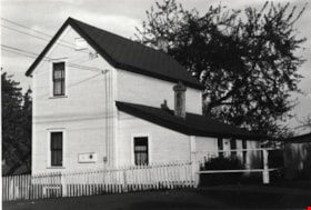
Royal Oak Funeral Chapel
https://search.heritageburnaby.ca/link/archivedescription36110
- Repository
- City of Burnaby Archives
- Date
- [1980]
- Collection/Fonds
- Burnaby Historical Society fonds
- Description Level
- Item
- Physical Description
- 1 photograph : b&w ; 11.5 x 16.5 cm
- Scope and Content
- Photograph of the Royal Oak Funeral Chapel at 3412 Kingsway taken from inside the stone fence. This building is also known as 'Glenedward' and its address has been renumbered 5152 Kingsway.
- Repository
- City of Burnaby Archives
- Date
- [1980]
- Collection/Fonds
- Burnaby Historical Society fonds
- Subseries
- Columbian Newspaper subseries
- Physical Description
- 1 photograph : b&w ; 11.5 x 16.5 cm
- Description Level
- Item
- Record No.
- 222-033
- Access Restriction
- No restrictions
- Reproduction Restriction
- Reproduce for fair dealing purposes only
- Accession Number
- BHS1989-19
- Scope and Content
- Photograph of the Royal Oak Funeral Chapel at 3412 Kingsway taken from inside the stone fence. This building is also known as 'Glenedward' and its address has been renumbered 5152 Kingsway.
- Names
- Royal Oak Funeral Chapel
- Media Type
- Photograph
- Notes
- Title based on contents of photograph
- 3 b&w copy negatives accompanying
- Geographic Access
- Kingsway
- Street Address
- 5152 Kingsway
- Historic Neighbourhood
- Central Park (Historic Neighbourhood)
- Planning Study Area
- Marlborough Area
Images
![Royal Oak Funeral Chapel, [1980] thumbnail](/media/Hpo/_Data/_Archives_Images/_Unrestricted/205/222-033.jpg)
![Royal Oak Funeral Chapel and stone fence, [1980] thumbnail](/media/Hpo/_Data/_Archives_Images/_Unrestricted/205/222-034.jpg?width=280)
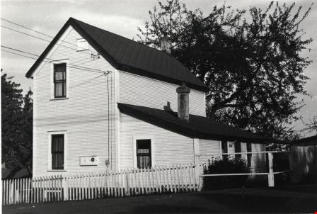
Royal Oak Funeral Chapel and stone fence
https://search.heritageburnaby.ca/link/archivedescription36111
- Repository
- City of Burnaby Archives
- Date
- [1980]
- Collection/Fonds
- Burnaby Historical Society fonds
- Description Level
- Item
- Physical Description
- 1 photograph : b&w ; 11.5 x 16.5 cm
- Scope and Content
- Photograph of the Royal Oak Funeral Chapel from the edge of the stone fence, to the right of the chapel located at 3412 Kingsway.This building is also known as 'Glenedward' and its address has been renumbered 5152 Kingsway.
- Repository
- City of Burnaby Archives
- Date
- [1980]
- Collection/Fonds
- Burnaby Historical Society fonds
- Subseries
- Columbian Newspaper subseries
- Physical Description
- 1 photograph : b&w ; 11.5 x 16.5 cm
- Description Level
- Item
- Record No.
- 222-034
- Access Restriction
- No restrictions
- Reproduction Restriction
- Reproduce for fair dealing purposes only
- Accession Number
- BHS1989-19
- Scope and Content
- Photograph of the Royal Oak Funeral Chapel from the edge of the stone fence, to the right of the chapel located at 3412 Kingsway.This building is also known as 'Glenedward' and its address has been renumbered 5152 Kingsway.
- Names
- Royal Oak Funeral Chapel
- Media Type
- Photograph
- Notes
- Title based on contents of photograph
- 3 b&w copy negatives accompanying
- Geographic Access
- Kingsway
- Street Address
- 5152 Kingsway
- Historic Neighbourhood
- Central Park (Historic Neighbourhood)
- Planning Study Area
- Marlborough Area
Images
![Royal Oak Funeral Chapel and stone fence, [1980] thumbnail](/media/Hpo/_Data/_Archives_Images/_Unrestricted/205/222-034.jpg)
Royal Oak Funeral Chapel and peaked fence
https://search.heritageburnaby.ca/link/archivedescription36112
- Repository
- City of Burnaby Archives
- Date
- September 17, 1980
- Collection/Fonds
- Burnaby Historical Society fonds
- Description Level
- Item
- Physical Description
- 1 photograph : b&w ; 16.5 x 22.5 cm
- Scope and Content
- Photograph of the Royal Oak Funeral Chapel at 3412 Kingsway taken from the edge of the peaked stone fence. A crow is pecking at the front lawn. This building is also known as 'Glenedward' and its address has been renumbered 5152 Kingsway.
- Repository
- City of Burnaby Archives
- Date
- September 17, 1980
- Collection/Fonds
- Burnaby Historical Society fonds
- Subseries
- Columbian Newspaper subseries
- Physical Description
- 1 photograph : b&w ; 16.5 x 22.5 cm
- Description Level
- Item
- Record No.
- 222-035
- Access Restriction
- No restrictions
- Reproduction Restriction
- Reproduce for fair dealing purposes only
- Accession Number
- BHS1989-19
- Scope and Content
- Photograph of the Royal Oak Funeral Chapel at 3412 Kingsway taken from the edge of the peaked stone fence. A crow is pecking at the front lawn. This building is also known as 'Glenedward' and its address has been renumbered 5152 Kingsway.
- Names
- Royal Oak Funeral Chapel
- Media Type
- Photograph
- Photographer
- Hodge, Craig
- Notes
- Title based on contents of photograph
- 3 b&w copy negatives accompanying
- Stamp on verso of photograph reads: "COLUMBIAN PHOTO BY CRAIG HODGE"
- Geographic Access
- Kingsway
- Street Address
- 5152 Kingsway
- Historic Neighbourhood
- Central Park (Historic Neighbourhood)
- Planning Study Area
- Marlborough Area
Images

![Royal Oak Funeral Chapel, [1980] thumbnail](/media/hpo/_Data/_Archives_Images/_Unrestricted/205/222-036.jpg?width=280)
Royal Oak Funeral Chapel
https://search.heritageburnaby.ca/link/archivedescription36113
- Repository
- City of Burnaby Archives
- Date
- [1980]
- Collection/Fonds
- Burnaby Historical Society fonds
- Description Level
- Item
- Physical Description
- 1 photograph : b&w ; 9 x 13.5 cm print
- Scope and Content
- Photograph of the bank of windows on the right and edge of the front door at the Royal Oak Funeral Chapel at 3142 Kingsway. The chapel's front walk handrail and ramp are also partially visible. This building is also known as 'Glenedward' and its address has been renumbered 5152 Kingsway.
- Repository
- City of Burnaby Archives
- Date
- [1980]
- Collection/Fonds
- Burnaby Historical Society fonds
- Subseries
- Columbian Newspaper subseries
- Physical Description
- 1 photograph : b&w ; 9 x 13.5 cm print
- Description Level
- Item
- Record No.
- 222-036
- Access Restriction
- No restrictions
- Reproduction Restriction
- Reproduce for fair dealing purposes only
- Accession Number
- BHS1989-19
- Scope and Content
- Photograph of the bank of windows on the right and edge of the front door at the Royal Oak Funeral Chapel at 3142 Kingsway. The chapel's front walk handrail and ramp are also partially visible. This building is also known as 'Glenedward' and its address has been renumbered 5152 Kingsway.
- Names
- Royal Oak Funeral Chapel
- Media Type
- Photograph
- Photographer
- Hodge, Craig
- Notes
- Title based on contents of photograph
- Stamp on verso of photograph reads: "COLUMBIAN PHOTO BY CRAIG HODGE"
- Geographic Access
- Kingsway
- Street Address
- 5152 Kingsway
- Historic Neighbourhood
- Central Park (Historic Neighbourhood)
- Planning Study Area
- Marlborough Area
Images
![Royal Oak Funeral Chapel, [1980] thumbnail](/media/hpo/_Data/_Archives_Images/_Unrestricted/205/222-036.jpg)

Corner of Buxton and Royal Oak
https://search.heritageburnaby.ca/link/archivedescription78895
- Repository
- City of Burnaby Archives
- Date
- February 7, 1977
- Collection/Fonds
- Burnaby Public Library Contemporary Visual Archive Project
- Description Level
- Item
- Physical Description
- 1 photograph : b&w ; 11 x 16 cm mounted on cardboard
- Scope and Content
- Photograph shows a house on the corner of Buxton Street and Royal Oak Avenue with a view of north Burnaby and the North Shore in the background.
- Repository
- City of Burnaby Archives
- Date
- February 7, 1977
- Collection/Fonds
- Burnaby Public Library Contemporary Visual Archive Project
- Physical Description
- 1 photograph : b&w ; 11 x 16 cm mounted on cardboard
- Description Level
- Item
- Record No.
- 556-020
- Access Restriction
- No restrictions
- Reproduction Restriction
- Reproduce for fair dealing purposes only
- Accession Number
- 2013-13
- Scope and Content
- Photograph shows a house on the corner of Buxton Street and Royal Oak Avenue with a view of north Burnaby and the North Shore in the background.
- Media Type
- Photograph
- Notes
- Scope note taken directly from BPL photograph description.
- 1 b&w copy negative : 10 x 12.5 cm accompanying
- Photographers identified by surnames only: Carr and Vardeman
- Geographic Access
- Buxton Street
- Royal Oak Avenue
- Historic Neighbourhood
- Central Park (Historic Neighbourhood)
- Planning Study Area
- Marlborough Area
Images


6100 Block McMurray Avenue
https://search.heritageburnaby.ca/link/archivedescription78912
- Repository
- City of Burnaby Archives
- Date
- February 7, 1977
- Collection/Fonds
- Burnaby Public Library Contemporary Visual Archive Project
- Description Level
- Item
- Physical Description
- 1 photograph : b&w ; 11 x 16 cm mounted on cardboard
- Scope and Content
- Photograph shows houses on 6100 Block McMurray Avenue, near Grange Street.
- Repository
- City of Burnaby Archives
- Date
- February 7, 1977
- Collection/Fonds
- Burnaby Public Library Contemporary Visual Archive Project
- Physical Description
- 1 photograph : b&w ; 11 x 16 cm mounted on cardboard
- Description Level
- Item
- Record No.
- 556-029
- Access Restriction
- No restrictions
- Reproduction Restriction
- Reproduce for fair dealing purposes only
- Accession Number
- 2013-13
- Scope and Content
- Photograph shows houses on 6100 Block McMurray Avenue, near Grange Street.
- Media Type
- Photograph
- Notes
- Scope note taken directly from BPL photograph description.
- 1 b&w copy negative : 10 x 12.5 cm accompanying
- Photographers identified by surnames only: Carr and Vardeman
- Geographic Access
- McMurray Avenue
- Historic Neighbourhood
- Central Park (Historic Neighbourhood)
- Planning Study Area
- Marlborough Area
Images


House at 6236 McMurray Avenue
https://search.heritageburnaby.ca/link/archivedescription78918
- Repository
- City of Burnaby Archives
- Date
- February 7, 1977
- Collection/Fonds
- Burnaby Public Library Contemporary Visual Archive Project
- Description Level
- Item
- Physical Description
- 1 photograph : b&w ; 11 x 16 cm mounted on cardboard
- Scope and Content
- Photograph shows cars in front of a house located at 6236 McMurray Avenue with a high-rise apartment building in the background.
- Repository
- City of Burnaby Archives
- Date
- February 7, 1977
- Collection/Fonds
- Burnaby Public Library Contemporary Visual Archive Project
- Physical Description
- 1 photograph : b&w ; 11 x 16 cm mounted on cardboard
- Description Level
- Item
- Record No.
- 556-033
- Access Restriction
- No restrictions
- Reproduction Restriction
- Reproduce for fair dealing purposes only
- Accession Number
- 2013-13
- Scope and Content
- Photograph shows cars in front of a house located at 6236 McMurray Avenue with a high-rise apartment building in the background.
- Media Type
- Photograph
- Notes
- Scope note taken directly from BPL photograph description.
- 1 b&w copy negative : 10 x 12.5 cm accompanying
- Photographers identified by surnames only: Carr and Vardeman
- Geographic Access
- McMurray Avenue
- Street Address
- 6236 McMurray Avenue
- Historic Neighbourhood
- Central Park (Historic Neighbourhood)
- Planning Study Area
- Marlborough Area
Images

West Burnaby United Church
https://search.heritageburnaby.ca/link/archivedescription79067
- Repository
- City of Burnaby Archives
- Date
- February 7, 1977
- Collection/Fonds
- Burnaby Public Library Contemporary Visual Archive Project
- Description Level
- Item
- Physical Description
- 1 photograph : b&w ; 11 x 16 cm mounted on cardboard
- Scope and Content
- Photograph shows the West Burnaby United Church located at 6050 Sussex Avenue on the corner of Sussex and Hazel Street.
- Repository
- City of Burnaby Archives
- Date
- February 7, 1977
- Collection/Fonds
- Burnaby Public Library Contemporary Visual Archive Project
- Physical Description
- 1 photograph : b&w ; 11 x 16 cm mounted on cardboard
- Description Level
- Item
- Record No.
- 556-130
- Access Restriction
- No restrictions
- Reproduction Restriction
- Reproduce for fair dealing purposes only
- Accession Number
- 2013-13
- Scope and Content
- Photograph shows the West Burnaby United Church located at 6050 Sussex Avenue on the corner of Sussex and Hazel Street.
- Subjects
- Buildings - Religious - Churches
- Media Type
- Photograph
- Notes
- Scope note taken directly from BPL photograph description.
- 1 b&w copy negative : 10 x 12.5 cm accompanying
- Photographers identified by surnames only: Carr and Vardeman
- Geographic Access
- Sussex Avenue
- Street Address
- 6050 Sussex Avenue
- Historic Neighbourhood
- Central Park (Historic Neighbourhood)
- Planning Study Area
- Marlborough Area
Images

The Runners' Shop
https://search.heritageburnaby.ca/link/archivedescription79168
- Repository
- City of Burnaby Archives
- Date
- February 7, 1977
- Collection/Fonds
- Burnaby Public Library Contemporary Visual Archive Project
- Description Level
- Item
- Physical Description
- 1 photograph : b&w ; 11 x 16 cm mounted on cardboard
- Scope and Content
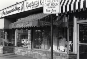
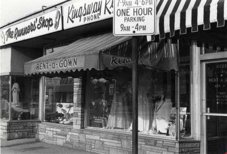
- Photograph shows the Runners' Shop at 4635 Kingsway and Kingsway Rent-a-Gown at 4639 Kingsway.
- Repository
- City of Burnaby Archives
- Date
- February 7, 1977
- Collection/Fonds
- Burnaby Public Library Contemporary Visual Archive Project
- Physical Description
- 1 photograph : b&w ; 11 x 16 cm mounted on cardboard
- Description Level
- Item
- Record No.
- 556-186
- Access Restriction
- No restrictions
- Reproduction Restriction
- Reproduce for fair dealing purposes only
- Accession Number
- 2013-13
- Scope and Content
- Photograph shows the Runners' Shop at 4635 Kingsway and Kingsway Rent-a-Gown at 4639 Kingsway.
- Media Type
- Photograph
- Notes
- Scope note taken directly from BPL photograph description.
- 1 b&w copy negative : 10 x 12.5 cm accompanying
- Photographers identified by surnames only: Carr and Vardeman
- Geographic Access
- Kingsway
- Street Address
- 4635 Kingsway
- 4639 Kingsway
- Historic Neighbourhood
- Central Park (Historic Neighbourhood)
- Planning Study Area
- Marlborough Area
Images

4700 Block Kingsway
https://search.heritageburnaby.ca/link/archivedescription79227
- Repository
- City of Burnaby Archives
- Date
- February 7, 1977
- Collection/Fonds
- Burnaby Public Library Contemporary Visual Archive Project
- Description Level
- Item
- Physical Description
- 1 photograph : b&w ; 11 x 16 cm mounted on cardboard
- Scope and Content
- Photograph shows small businesses in the 4700 block Kingsway looking east along Kingsway. Businesses include William's Cafe, Fire Places Unlimited and Vacuum Self-Service.
- Repository
- City of Burnaby Archives
- Date
- February 7, 1977
- Collection/Fonds
- Burnaby Public Library Contemporary Visual Archive Project
- Physical Description
- 1 photograph : b&w ; 11 x 16 cm mounted on cardboard
- Description Level
- Item
- Record No.
- 556-210
- Access Restriction
- No restrictions
- Reproduction Restriction
- Reproduce for fair dealing purposes only
- Accession Number
- 2013-13
- Scope and Content
- Photograph shows small businesses in the 4700 block Kingsway looking east along Kingsway. Businesses include William's Cafe, Fire Places Unlimited and Vacuum Self-Service.
- Media Type
- Photograph
- Notes
- Scope note taken directly from BPL photograph description.
- 1 b&w copy negative : 10 x 12.5 cm accompanying
- Photographers identified by surnames only: Carr and Vardeman
- Geographic Access
- Kingsway
- Historic Neighbourhood
- Central Park (Historic Neighbourhood)
- Planning Study Area
- Marlborough Area
Images


Closed Gas Station
https://search.heritageburnaby.ca/link/archivedescription79271
- Repository
- City of Burnaby Archives
- Date
- February 7, 1977
- Collection/Fonds
- Burnaby Public Library Contemporary Visual Archive Project
- Description Level
- Item
- Physical Description
- 1 photograph : b&w ; 11 x 16 cm mounted on cardboard
- Scope and Content
- Photograph shows a closed gas station on Kingsway near McKercher Avenue.
- Repository
- City of Burnaby Archives
- Date
- February 7, 1977
- Collection/Fonds
- Burnaby Public Library Contemporary Visual Archive Project
- Physical Description
- 1 photograph : b&w ; 11 x 16 cm mounted on cardboard
- Description Level
- Item
- Record No.
- 556-233
- Access Restriction
- No restrictions
- Reproduction Restriction
- Reproduce for fair dealing purposes only
- Accession Number
- 2013-13
- Scope and Content
- Photograph shows a closed gas station on Kingsway near McKercher Avenue.
- Media Type
- Photograph
- Notes
- Scope note taken directly from BPL photograph description.
- 1 b&w copy negative : 10 x 12.5 cm accompanying
- Photographers identified by surnames only: Carr and Vardeman
- Geographic Access
- McKercher Avenue
- Kingsway
- Historic Neighbourhood
- Central Park (Historic Neighbourhood)
- Planning Study Area
- Marlborough Area
Images


Astor Hotel
https://search.heritageburnaby.ca/link/archivedescription93657
- Repository
- City of Burnaby Archives
- Date
- November 13, 1977
- Collection/Fonds
- Burnaby Public Library Contemporary Visual Archive Project
- Description Level
- Item
- Physical Description
- 1 photograph : b&w ; 12.5 x 17.5 cm
- Scope and Content
- Photograph of the exterior of the Astor Motor Hotel and its hotel sign, located on the 4500 block of Kingsway. The photograph is taken facing northeast.
- Repository
- City of Burnaby Archives
- Date
- November 13, 1977
- Collection/Fonds
- Burnaby Public Library Contemporary Visual Archive Project
- Physical Description
- 1 photograph : b&w ; 12.5 x 17.5 cm
- Description Level
- Item
- Record No.
- 556-614
- Access Restriction
- No restrictions
- Reproduction Restriction
- Reproduce for fair dealing purposes only
- Accession Number
- 2017-57
- Scope and Content
- Photograph of the exterior of the Astor Motor Hotel and its hotel sign, located on the 4500 block of Kingsway. The photograph is taken facing northeast.
- Names
- Astor Hotel
- Media Type
- Photograph
- Photographer
- Chapman, Fred
- Notes
- Title taken from project information form
- Accompanied by a project information form and 1 photograph (b&w negative ; 9.5 x 12.5 cm)
- BPL no. 64
- Geographic Access
- Kingsway
- Street Address
- 4561 Kingsway
- Historic Neighbourhood
- Central Park (Historic Neighbourhood)
- Planning Study Area
- Marlborough Area
Images

House on Nelson Avenue
https://search.heritageburnaby.ca/link/archivedescription78909
- Repository
- City of Burnaby Archives
- Date
- September 15, 1976
- Collection/Fonds
- Burnaby Public Library Contemporary Visual Archive Project
- Description Level
- Item
- Physical Description
- 1 photograph : b&w ; 11 x 16 cm mounted on cardboard
- Scope and Content
- Photograph shows a burned out house on Nelson Avenue near Maitland Street. A basement fire destroyed the house a few days before the photograph was taken.
- Repository
- City of Burnaby Archives
- Date
- September 15, 1976
- Collection/Fonds
- Burnaby Public Library Contemporary Visual Archive Project
- Physical Description
- 1 photograph : b&w ; 11 x 16 cm mounted on cardboard
- Description Level
- Item
- Record No.
- 556-027
- Access Restriction
- No restrictions
- Reproduction Restriction
- Reproduce for fair dealing purposes only
- Accession Number
- 2013-13
- Scope and Content
- Photograph shows a burned out house on Nelson Avenue near Maitland Street. A basement fire destroyed the house a few days before the photograph was taken.
- Media Type
- Photograph
- Photographer
- McCarron, John
- Notes
- Scope note taken directly from BPL photograph description.
- 1 b&w copy negative : 10 x 12.5 cm accompanying
- Geographic Access
- Nelson Avenue
- Historic Neighbourhood
- Central Park (Historic Neighbourhood)
- Planning Study Area
- Marlborough Area
Images
House at 4551 Price Street
https://search.heritageburnaby.ca/link/archivedescription78919
- Repository
- City of Burnaby Archives
- Date
- November 1, 1976
- Collection/Fonds
- Burnaby Public Library Contemporary Visual Archive Project
- Description Level
- Item
- Physical Description
- 1 photograph : b&w ; 11 x 16 cm mounted on cardboard
- Scope and Content
- Photograph shows a house located at 4551 Price Street.
- Repository
- City of Burnaby Archives
- Date
- November 1, 1976
- Collection/Fonds
- Burnaby Public Library Contemporary Visual Archive Project
- Physical Description
- 1 photograph : b&w ; 11 x 16 cm mounted on cardboard
- Description Level
- Item
- Record No.
- 556-034
- Access Restriction
- No restrictions
- Reproduction Restriction
- Reproduce for fair dealing purposes only
- Accession Number
- 2013-13
- Scope and Content
- Photograph shows a house located at 4551 Price Street.
- Media Type
- Photograph
- Notes
- Scope note taken directly from BPL photograph description.
- 1 b&w copy negative : 10 x 12.5 cm accompanying
- Photographers identified by surnames only: Carr and Vardeman
- Geographic Access
- Price Street
- Street Address
- 4551 Price Street
- Historic Neighbourhood
- Central Park (Historic Neighbourhood)
- Planning Study Area
- Marlborough Area
Images

House at 6262 Nelson Avenue
https://search.heritageburnaby.ca/link/archivedescription78951
- Repository
- City of Burnaby Archives
- Date
- September 15,1976
- Collection/Fonds
- Burnaby Public Library Contemporary Visual Archive Project
- Description Level
- Item
- Physical Description
- 1 photograph : b&w ; 11 x 16 cm mounted on cardboard
- Scope and Content
- Photograph shows a house at 6262 Nelson Avenue, near Kingsway, with a high-rise apartment building in the background.
- Repository
- City of Burnaby Archives
- Date
- September 15,1976
- Collection/Fonds
- Burnaby Public Library Contemporary Visual Archive Project
- Physical Description
- 1 photograph : b&w ; 11 x 16 cm mounted on cardboard
- Description Level
- Item
- Record No.
- 556-046
- Access Restriction
- No restrictions
- Reproduction Restriction
- Reproduce for fair dealing purposes only
- Accession Number
- 2013-13
- Scope and Content
- Photograph shows a house at 6262 Nelson Avenue, near Kingsway, with a high-rise apartment building in the background.
- Subjects
- Buildings - Residential - Apartments
- Media Type
- Photograph
- Photographer
- McCarron, John
- Notes
- Scope note taken directly from BPL photograph description.
- 1 b&w copy negative : 10 x 12.5 cm accompanying
- Geographic Access
- Nelson Avenue
- Street Address
- 6262 Nelson Avenue
- Historic Neighbourhood
- Central Park (Historic Neighbourhood)
- Planning Study Area
- Marlborough Area
Images

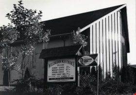
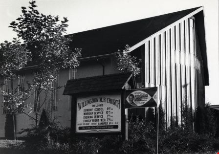
Willingdon Mennonite Brethren Church
https://search.heritageburnaby.ca/link/archivedescription79069
- Repository
- City of Burnaby Archives
- Date
- November 1, 1976
- Collection/Fonds
- Burnaby Public Library Contemporary Visual Archive Project
- Description Level
- Item
- Physical Description
- 1 photograph : b&w ; 11 x 16 cm mounted on cardboard
- Scope and Content
- Photograph shows the Willingdon Mennonite Brethren Church locate at 4812 Willingdon Avenue at the corner of Gilpin Street. Exterior sign gives details of services and advertises an upcoming appearance by Leighton Ford.
- Repository
- City of Burnaby Archives
- Date
- November 1, 1976
- Collection/Fonds
- Burnaby Public Library Contemporary Visual Archive Project
- Physical Description
- 1 photograph : b&w ; 11 x 16 cm mounted on cardboard
- Description Level
- Item
- Record No.
- 556-131
- Access Restriction
- No restrictions
- Reproduction Restriction
- Reproduce for fair dealing purposes only
- Accession Number
- 2013-13
- Scope and Content
- Photograph shows the Willingdon Mennonite Brethren Church locate at 4812 Willingdon Avenue at the corner of Gilpin Street. Exterior sign gives details of services and advertises an upcoming appearance by Leighton Ford.
- Subjects
- Buildings - Religious - Churches
- Media Type
- Photograph
- Notes
- Scope note taken directly from BPL photograph description.
- 1 b&w copy negative : 10 x 12.5 cm accompanying
- Photographers identified by surnames only: Carr and Vardeman
- Geographic Access
- Willingdon Avenue
- Street Address
- 4812 Willingdon Avenue
- Historic Neighbourhood
- Central Park (Historic Neighbourhood)
- Planning Study Area
- Marlborough Area
Images

Royal Oak Chapel
https://search.heritageburnaby.ca/link/archivedescription79071
- Repository
- City of Burnaby Archives
- Date
- September 13, 1976
- Collection/Fonds
- Burnaby Public Library Contemporary Visual Archive Project
- Description Level
- Item
- Physical Description
- 1 photograph : b&w ; 11 x 16 cm mounted on cardboard
- Scope and Content
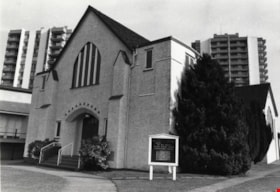
- Photograph shows the Royal Oak Chapel at 5152 Kingsway at the corner of Royal Oak Avenue. This building was built by Andrew and Margaret Johnson (and known as Glenedward) in 1911-1912 and was a private residence until 1946, at which time it became a funeral home.
- Repository
- City of Burnaby Archives
- Date
- September 13, 1976
- Collection/Fonds
- Burnaby Public Library Contemporary Visual Archive Project
- Physical Description
- 1 photograph : b&w ; 11 x 16 cm mounted on cardboard
- Description Level
- Item
- Record No.
- 556-133
- Access Restriction
- No restrictions
- Reproduction Restriction
- Reproduce for fair dealing purposes only
- Accession Number
- 2013-13
- Scope and Content
- Photograph shows the Royal Oak Chapel at 5152 Kingsway at the corner of Royal Oak Avenue. This building was built by Andrew and Margaret Johnson (and known as Glenedward) in 1911-1912 and was a private residence until 1946, at which time it became a funeral home.
- Names
- Royal Oak Funeral Chapel
- Media Type
- Photograph
- Photographer
- McCarron, John
- Notes
- Scope note taken directly from BPL photograph description.
- 1 b&w copy negative : 10 x 12.5 cm accompanying
- Geographic Access
- Kingsway
- Street Address
- 5152 Kingsway
- Historic Neighbourhood
- Central Park (Historic Neighbourhood)
- Planning Study Area
- Marlborough Area
Images


Royal Oak Grocery
https://search.heritageburnaby.ca/link/archivedescription79092
- Repository
- City of Burnaby Archives
- Date
- September 13, 1976
- Collection/Fonds
- Burnaby Public Library Contemporary Visual Archive Project
- Description Level
- Item
- Physical Description
- 1 photograph : b&w ; 11 x 16 cm mounted on cardboard
- Scope and Content
- Photograph shows Royal Oak Grocery located at 6537 Royal Oak Avenue. The store was built in approximately 1946 and has living quarters above.
- Repository
- City of Burnaby Archives
- Date
- September 13, 1976
- Collection/Fonds
- Burnaby Public Library Contemporary Visual Archive Project
- Physical Description
- 1 photograph : b&w ; 11 x 16 cm mounted on cardboard
- Description Level
- Item
- Record No.
- 556-146
- Access Restriction
- No restrictions
- Reproduction Restriction
- Reproduce for fair dealing purposes only
- Accession Number
- 2013-13
- Scope and Content
- Photograph shows Royal Oak Grocery located at 6537 Royal Oak Avenue. The store was built in approximately 1946 and has living quarters above.
- Names
- Royal Oak Grocery
- Media Type
- Photograph
- Photographer
- McCarron, John
- Notes
- Scope note taken directly from BPL photograph description.
- 1 b&w copy negative : 10 x 12.5 cm accompanying
- Geographic Access
- Royal Oak Avenue
- Street Address
- 6537 Royal Oak Avenue
- Historic Neighbourhood
- Central Park (Historic Neighbourhood)
- Planning Study Area
- Marlborough Area
Images
