Narrow Results By
Subject
- Buildings - Commercial 1
- Buildings - Heritage 12
- Buildings - Other 2
- Buildings - Recreational - Community Halls 1
- Buildings - Religious 12
- Buildings - Residential - Apartments 2
- Buildings - Schools 1
- Construction 1
- Construction Tools and Equipment 1
- Exhibitions 1
- Occupations - Labourers 1
- Organizations - Societies and Clubs 1

Marlborough Neighbourhood
https://search.heritageburnaby.ca/link/landmark802
- Repository
- Burnaby Heritage Planning
- Associated Dates
- 1955-2008
- Heritage Value
- The Marlborough Neighbourhood is another residential area that was witness to rapid growth and subdivision during the 1950s and 1960s, creating primarily single-family housing stock. In the 1970s and 1980s, as the commercial district around Kingsway grew, so too did higher density housing projects such as townhomes and condominiums.
- Historic Neighbourhood
- Central Park (Historic Neighbourhood)
- Planning Study Area
- Marlborough Area
Images


South Burnaby Cenotaph
https://search.heritageburnaby.ca/link/landmark860
- Repository
- Burnaby Heritage Planning
- Description
- The South Burnaby Cenotaph is located in Bonsor Park at the corner of Nelson Avenue and Imperial Street. The cenotaph commemorates those lost in the First World War, Second World War and the Korean War.
- Associated Dates
- 1988
- Other Names
- Bonsor Park Cenotaph
- Street View URL
- Google Maps Street View
- Repository
- Burnaby Heritage Planning
- Other Names
- Bonsor Park Cenotaph
- Geographic Access
- Nelson Avenue
- Associated Dates
- 1988
- Description
- The South Burnaby Cenotaph is located in Bonsor Park at the corner of Nelson Avenue and Imperial Street. The cenotaph commemorates those lost in the First World War, Second World War and the Korean War.
- Historic Neighbourhood
- Central Park (Historic Neighbourhood)
- Planning Study Area
- Marlborough Area
- Community
- Burnaby
- Cadastral Identifier
- P.I.D. No. 027-719-375
- Boundaries
- The property (Bonsor Park) is comprised of a single municipally-owned property located at 6749 Nelson Avenue.
- Area
- 3570.00
- Contributing Resource
- Landscape Feature
- Structure
- Ownership
- Public (local)
- Street Address
- 6749 Nelson Avenue
- Street View URL
- Google Maps Street View
Images

![Gilley Brothers Logging team, [1895]. . thumbnail](/media/hpo/_Data/_Archives_Images/_Unrestricted/371/461-003.jpg?width=280)
Vancouver Road (Kingsway)
https://search.heritageburnaby.ca/link/landmark729
- Repository
- Burnaby Heritage Planning
- Associated Dates
- 1860
- Heritage Value
- The street we know as Kingsway is one of the legacies of the Royal Engineers' military defences for New Westminster. The fear of an American attack prompted the construction of the False Creek trail - later known as Vancouver Road and now Kingsway - in 1860 to connect the capital city to the ice-free salt water harbour at English Bay.
- Historic Neighbourhood
- Central Park (Historic Neighbourhood)
- Edmonds (Historic Neighbourhood)
- Planning Study Area
- Maywood Area
- Marlborough Area
- Windsor Area
- Kingsway-Beresford Area
- Stride Avenue Area
- Edmonds Area
Images
![Gilley Brothers Logging team, [1895]. . thumbnail](/media/hpo/_Data/_Archives_Images/_Unrestricted/371/461-003.jpg)
4955-4957 Newton St.
https://search.heritageburnaby.ca/link/archivedescription94325
- Repository
- City of Burnaby Archives
- Date
- November 1994
- Collection/Fonds
- Grover, Elliott & Co. Ltd. fonds
- Description Level
- File
- Physical Description
- 22 photographs : col. negatives ; 35 mm
- Scope and Content
- Photographs of high-rise apartment towers located at 4595 and 4957 Newton Street. The former address no longer exists.
- Repository
- City of Burnaby Archives
- Date
- November 1994
- Collection/Fonds
- Grover, Elliott & Co. Ltd. fonds
- Physical Description
- 22 photographs : col. negatives ; 35 mm
- Description Level
- File
- Record No.
- 622-110
- Access Restriction
- No restrictions
- Reproduction Restriction
- No restrictions
- Accession Number
- 2017-39
- Scope and Content
- Photographs of high-rise apartment towers located at 4595 and 4957 Newton Street. The former address no longer exists.
- Subjects
- Buildings - Residential - Apartments
- Media Type
- Photograph
- Notes
- Transcribed title
- Title transcribed from envelope photographs were originally housed in
- File no. 94-408-B
- Geographic Access
- Newton Street
- Street Address
- 4955 Newton Street
- Historic Neighbourhood
- Central Park (Historic Neighbourhood)
- Planning Study Area
- Marlborough Area
4960 Sanders St.
https://search.heritageburnaby.ca/link/archivedescription93764
- Repository
- City of Burnaby Archives
- Date
- July 13, 1992
- Collection/Fonds
- Grover, Elliott & Co. Ltd. fonds
- Description Level
- File
- Physical Description
- 63 photographs : col. negatives ; 35 mm
- Scope and Content
- Photographs of the exterior of Horizon Tower, a high-rise apartment complex located at 4960 Sanders Street. Photographs of the tower are taken from several vantage points.
- Repository
- City of Burnaby Archives
- Date
- July 13, 1992
- Collection/Fonds
- Grover, Elliott & Co. Ltd. fonds
- Physical Description
- 63 photographs : col. negatives ; 35 mm
- Description Level
- File
- Record No.
- 622-049
- Access Restriction
- No restrictions
- Reproduction Restriction
- No restrictions
- Accession Number
- 2017-39
- Scope and Content
- Photographs of the exterior of Horizon Tower, a high-rise apartment complex located at 4960 Sanders Street. Photographs of the tower are taken from several vantage points.
- Subjects
- Buildings - Residential - Apartments
- Media Type
- Photograph
- Notes
- Transcribed title
- Title transcribed from envelope photographs were originally housed in
- File no. 92-262-B
- Geographic Access
- Sanders Street
- Street Address
- 4960 Sanders Street
- Historic Neighbourhood
- Central Park (Historic Neighbourhood)
- Planning Study Area
- Marlborough Area
![Backyard playhouse, [199-] (date of original), digitally copied 2012 thumbnail](/media/hpo/_Data/_Archives_Images/_Unrestricted/540/549-022.jpg?width=280)
Backyard playhouse
https://search.heritageburnaby.ca/link/archivedescription76901
- Repository
- City of Burnaby Archives
- Date
- [199-] (date of original), digitally copied 2012
- Collection/Fonds
- Community Heritage Commission Special Projects fonds
- Description Level
- Item
- Physical Description
- 1 photograph (jpeg) : col. ; 300ppi
- Scope and Content
- Photograph of the original backyard playhouse on the Champion family property (the windows on the playhouse are from an early Stanley Park beach house).
- Repository
- City of Burnaby Archives
- Date
- [199-] (date of original), digitally copied 2012
- Collection/Fonds
- Community Heritage Commission Special Projects fonds
- Physical Description
- 1 photograph (jpeg) : col. ; 300ppi
- Description Level
- Item
- Record No.
- 549-022
- Access Restriction
- No restrictions
- Reproduction Restriction
- Reproduce for fair dealing purposes only
- Accession Number
- 2012-30
- Scope and Content
- Photograph of the original backyard playhouse on the Champion family property (the windows on the playhouse are from an early Stanley Park beach house).
- Subjects
- Buildings - Other
- Media Type
- Photograph
- Notes
- Title based on contents of photograph
- Historic Neighbourhood
- Central Park (Historic Neighbourhood)
- Planning Study Area
- Marlborough Area
Images
![Backyard playhouse, [199-] (date of original), digitally copied 2012 thumbnail](/media/hpo/_Data/_Archives_Images/_Unrestricted/540/549-022.jpg)
![Backyard shed, [199-] (date of original), digitally copied 2012 thumbnail](/media/hpo/_Data/_Archives_Images/_Unrestricted/540/549-023.jpg?width=280)
Backyard shed
https://search.heritageburnaby.ca/link/archivedescription76902
- Repository
- City of Burnaby Archives
- Date
- [199-] (date of original), digitally copied 2012
- Collection/Fonds
- Community Heritage Commission Special Projects fonds
- Description Level
- Item
- Physical Description
- 1 photograph (jpeg) : col. ; 300ppi
- Scope and Content
- Photograph of the original backyard shed on the Champion family property.
- Repository
- City of Burnaby Archives
- Date
- [199-] (date of original), digitally copied 2012
- Collection/Fonds
- Community Heritage Commission Special Projects fonds
- Physical Description
- 1 photograph (jpeg) : col. ; 300ppi
- Description Level
- Item
- Record No.
- 549-023
- Access Restriction
- No restrictions
- Reproduction Restriction
- Reproduce for fair dealing purposes only
- Accession Number
- 2012-30
- Scope and Content
- Photograph of the original backyard shed on the Champion family property.
- Subjects
- Buildings - Other
- Media Type
- Photograph
- Notes
- Title based on contents of photograph
- Historic Neighbourhood
- Central Park (Historic Neighbourhood)
- Planning Study Area
- Marlborough Area
Images
![Backyard shed, [199-] (date of original), digitally copied 2012 thumbnail](/media/hpo/_Data/_Archives_Images/_Unrestricted/540/549-023.jpg)

Bonsor Hall
https://search.heritageburnaby.ca/link/archivedescription38282
- Repository
- City of Burnaby Archives
- Date
- 1986
- Collection/Fonds
- Burnaby Historical Society fonds
- Description Level
- Item
- Physical Description
- 1 photograph : col. ; 10 x 13 cm
- Scope and Content
- Photograph of the Bonsor Hall (originally 6637 Fern Avenue). In the foreground, construction debris can be seen and the skytrain is visible in the background. A note with this photograph indicates that this building was originally the Burnaby School Board Office.
- Repository
- City of Burnaby Archives
- Date
- 1986
- Collection/Fonds
- Burnaby Historical Society fonds
- Subseries
- Photographs subseries
- Physical Description
- 1 photograph : col. ; 10 x 13 cm
- Description Level
- Item
- Record No.
- 386-001
- Access Restriction
- No restrictions
- Reproduction Restriction
- Reproduce for fair dealing purposes only
- Accession Number
- BHS2007-04
- Scope and Content
- Photograph of the Bonsor Hall (originally 6637 Fern Avenue). In the foreground, construction debris can be seen and the skytrain is visible in the background. A note with this photograph indicates that this building was originally the Burnaby School Board Office.
- Names
- Bonsor Hall
- Media Type
- Photograph
- Notes
- Title based on contents of photograph.
- Geographic Access
- Fern Avenue
- Historic Neighbourhood
- Central Park (Historic Neighbourhood)
- Planning Study Area
- Marlborough Area
Images

![Burnaby French Language Preschool construction, [1999] thumbnail](/media/hpo/_Data/_Archives_Images/_Unrestricted/535/535-3308-1.jpg?width=280)
Burnaby French Language Preschool construction
https://search.heritageburnaby.ca/link/archivedescription98230
- Repository
- City of Burnaby Archives
- Date
- [1999]
- Collection/Fonds
- Burnaby NewsLeader photograph collection
- Description Level
- File
- Physical Description
- 2 photographs (tiff) : col.
- Scope and Content
- File contains photographs showing unidentified construction workers taking down and moving portables at the Burnaby French Language Preschool.
- Repository
- City of Burnaby Archives
- Date
- [1999]
- Collection/Fonds
- Burnaby NewsLeader photograph collection
- Physical Description
- 2 photographs (tiff) : col.
- Description Level
- File
- Record No.
- 535-3308
- Access Restriction
- No restrictions
- Reproduction Restriction
- No restrictions
- Accession Number
- 2018-12
- Scope and Content
- File contains photographs showing unidentified construction workers taking down and moving portables at the Burnaby French Language Preschool.
- Media Type
- Photograph
- Notes
- Title based on contents of file
- Collected by editorial for use in an August 1999 issue of the Burnaby NewsLeader
- Geographic Access
- Marlborough Avenue
- Street Address
- 6060 Marlborough Avenue
- Historic Neighbourhood
- Central Park (Historic Neighbourhood)
- Planning Study Area
- Marlborough Area
Images
![Burnaby French Language Preschool construction, [1999] thumbnail](/media/hpo/_Data/_Archives_Images/_Unrestricted/535/535-3308-1.jpg)
![Burnaby Laphounds Club rock and gem show, [1999] thumbnail](/media/hpo/_Data/_Archives_Images/_Unrestricted/535/535-3369.jpg?width=280)
Burnaby Laphounds Club rock and gem show
https://search.heritageburnaby.ca/link/archivedescription98359
- Repository
- City of Burnaby Archives
- Date
- [1999]
- Collection/Fonds
- Burnaby NewsLeader photograph collection
- Description Level
- Item
- Physical Description
- 1 photograph (tiff) : col.
- Scope and Content
- Photograph of Fred Wilson, wearing magnifying glasses and examining a piece of blue laser quartz, at a rock and gem show hosted by the Burnaby Laphounds Club at the Bonsor Recreation Centre.
- Repository
- City of Burnaby Archives
- Date
- [1999]
- Collection/Fonds
- Burnaby NewsLeader photograph collection
- Physical Description
- 1 photograph (tiff) : col.
- Description Level
- Item
- Record No.
- 535-3369
- Access Restriction
- No restrictions
- Reproduction Restriction
- No restrictions
- Accession Number
- 2018-12
- Scope and Content
- Photograph of Fred Wilson, wearing magnifying glasses and examining a piece of blue laser quartz, at a rock and gem show hosted by the Burnaby Laphounds Club at the Bonsor Recreation Centre.
- Media Type
- Photograph
- Photographer
- Bartel, Mario
- Notes
- Title based on caption
- Collected by editorial for use in an October 1999 issue of the Burnaby NewsLeader
- Caption from metadata: "Fred Wilson examines a chunk of blue laser quartz at a rock and gem show, hosted by the Burnaby Laphounds Club, at Bonsor Rec. Centre."
- Geographic Access
- Bonsor Avenue
- Street Address
- 6550 Bonsor Avenue
- Historic Neighbourhood
- Central Park (Historic Neighbourhood)
- Planning Study Area
- Marlborough Area
Images
![Burnaby Laphounds Club rock and gem show, [1999] thumbnail](/media/hpo/_Data/_Archives_Images/_Unrestricted/535/535-3369.jpg)

Empty lot
https://search.heritageburnaby.ca/link/archivedescription38283
- Repository
- City of Burnaby Archives
- Date
- 1987
- Collection/Fonds
- Burnaby Historical Society fonds
- Description Level
- Item
- Physical Description
- 1 photograph : col. ; 8.9 x 11 cm
- Scope and Content
- Photograph of the site of Bonsor Hall, on Fern Avenue, after demolition. A blue car is visible.
- Repository
- City of Burnaby Archives
- Date
- 1987
- Collection/Fonds
- Burnaby Historical Society fonds
- Subseries
- Photographs subseries
- Physical Description
- 1 photograph : col. ; 8.9 x 11 cm
- Description Level
- Item
- Record No.
- 386-002
- Access Restriction
- No restrictions
- Reproduction Restriction
- Reproduce for fair dealing purposes only
- Accession Number
- BHS2007-04
- Scope and Content
- Photograph of the site of Bonsor Hall, on Fern Avenue, after demolition. A blue car is visible.
- Subjects
- Transportation - Automobiles
- Media Type
- Photograph
- Notes
- Title based on contents of photograph
- Geographic Access
- Fern Avenue
- Historic Neighbourhood
- Central Park (Historic Neighbourhood)
- Planning Study Area
- Marlborough Area
Images


Interview with Don Brown by Rod Fowler February 26, 1990 - Track 8
https://search.heritageburnaby.ca/link/oralhistory509
- Repository
- City of Burnaby Archives
- Date Range
- 1947-1990
- Length
- 00:11:47
- Summary
- This portion of the interview is about Don Brown identifying old businesses and stores on Kingsway, and talking about the operation of the interurban, the lack of cars after the war, and the two vehicles used by the Burnaby police in 1948. He talks about the expansion of Burnaby in the 1950‘s and t…
- Repository
- City of Burnaby Archives
- Summary
- This portion of the interview is about Don Brown identifying old businesses and stores on Kingsway, and talking about the operation of the interurban, the lack of cars after the war, and the two vehicles used by the Burnaby police in 1948. He talks about the expansion of Burnaby in the 1950‘s and the attempts to preserve heritage buildings and trees, historic records, and green space
- Date Range
- 1947-1990
- Photo Info
- Royal Canadian Mounted Police Sergeant Don Brown, November 2, 1997. Item no. 535-0979
- Length
- 00:11:47
- Historic Neighbourhood
- Central Park (Historic Neighbourhood)
- Planning Study Area
- Marlborough Area
- Maywood Area
- Interviewer
- Fowler, Rod
- Interview Date
- February 26, 1990
- Scope and Content
- Recording is of an interview with Don Brown, conducted by Rod Fowler. Don Brown was one of eleven participants interviewed as part of the SFU/Burnaby Centennial Committee's oral history series titled, "Voices of Burnaby". The interview is mainly about Don Brown’s description of the changes in Burnaby’s built and natural landscapes and socioeconomic conditions, especially between 1947 and 1975, the strong impression made on him by those changes evident in the interview. He talks about his work and career as a police officer with the Burnaby Provincial Police and RCMP. The interview also details his involvement in Burnaby politics and volunteer community groups. To view “Narrow By” terms for each track expand this description and see “Notes”.
- Biographical Notes
- Donald Neil “Don” Brown was born in Birmingham, England May 4, 1919, and immigrated with his parents and siblings to Winnipeg in 1922. At the outbreak of WWII Don Brown left high school and enlisted in the 12th Field Company, Royal Canadian Engineers, serving six years in the army. Before going overseas he married Helen Birch in 1939. In 1947 Don Brown joined the B.C. Provincial Police which was absorbed by the RCMP in 1950. He worked as a police officer in Burnaby from 1947 to 1954, and then was transferred to Ottawa (with a stop in Regina) for nine and a half years where he attended Carleton University to study forensics. In 1963 Don Brown was transferred back to Vancouver and bought and moved into a house on Watling Street in Burnaby where he still lived in 1990. Another transfer took him to Edmonton for five years, returning to Burnaby in 1975. Following retirement in 1980 with the rank of Supervisor and after 22 years in forensic laboratories, Don Brown started his own business as a private document examiner. Don Brown was active in Burnaby politics, serving as Alderman from 1979-1985. He was also involved in many community groups including the South Burnaby Men’s Club, which he helped found in 1952, as well as active in the Burnaby Historical Society, and served on the Burnaby School Board, Burnaby Centennial Committee, and the Community College for the Retired. Don and Helen Brown had six children: Donna, Don, Gina, Patricia, Christopher and Susan. Don Brown died May 16, 2009.
- Total Tracks
- 14
- Total Length
- 01:35:07
- Interviewee Name
- Brown, Donald N. "Don"
- Interviewer Bio
- Rod Fowler returned to university as a mature student in the 1980s after working about twenty years in the field of economics and computerization in business in England, Europe and Western Canada. He graduated with a BA from SFU in both History and Sociology in 1987, his MA degree in Geography in 1989, and his PhD in Cultural Geography at SFU. He taught courses in Geography, Sociology, History and Canadian Studies at several Lower Mainland colleges, before becoming a full time member of the Geography Department at Kwantlen University College.
- Collection/Fonds
- SFU/Burnaby Centennial Committee fonds
- Transcript Available
- Transcript available
- Media Type
- Sound Recording
- Web Notes
- Interviews were digitized in 2015 allowing them to be accessible on Heritage Burnaby. The digitization project was initiated by the Community Heritage Commission with support from City of Burnaby Council.
Images

Audio Tracks
Track eight of interview with Don Brown
Track eight of interview with Don Brown
https://search.heritageburnaby.ca/media/hpo/_Data/_Archives_Oral_Histories/_Unrestricted/MSS187-016/MSS187-016_Track%208.mp3![Painting a SkyTrain station, [1999] thumbnail](/media/hpo/_Data/_Archives_Images/_Unrestricted/535/535-3317.jpg?width=280)
Painting a SkyTrain station
https://search.heritageburnaby.ca/link/archivedescription98250
- Repository
- City of Burnaby Archives
- Date
- [1999]
- Collection/Fonds
- Burnaby NewsLeader photograph collection
- Description Level
- Item
- Physical Description
- 1 photograph (tiff) : col.
- Scope and Content
- Photograph of a worker touching up the paint on part of the Royal Oak SkyTrain station.
- Repository
- City of Burnaby Archives
- Date
- [1999]
- Collection/Fonds
- Burnaby NewsLeader photograph collection
- Physical Description
- 1 photograph (tiff) : col.
- Description Level
- Item
- Record No.
- 535-3317
- Access Restriction
- No restrictions
- Reproduction Restriction
- No restrictions
- Accession Number
- 2018-12
- Scope and Content
- Photograph of a worker touching up the paint on part of the Royal Oak SkyTrain station.
- Media Type
- Photograph
- Notes
- Title based on contents of photograph
- Collected by editorial for use in a September 1999 issue of the Burnaby NewsLeader
- Geographic Access
- Royal Oak Avenue
- Historic Neighbourhood
- Central Park (Historic Neighbourhood)
- Planning Study Area
- Marlborough Area
Images
![Painting a SkyTrain station, [1999] thumbnail](/media/hpo/_Data/_Archives_Images/_Unrestricted/535/535-3317.jpg)
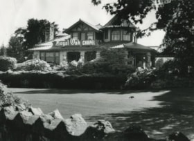
![Royal Oak Funeral Chapel, [1980] thumbnail](/media/Hpo/_Data/_Archives_Images/_Unrestricted/205/222-033.jpg?width=280)
Royal Oak Funeral Chapel
https://search.heritageburnaby.ca/link/archivedescription36110
- Repository
- City of Burnaby Archives
- Date
- [1980]
- Collection/Fonds
- Burnaby Historical Society fonds
- Description Level
- Item
- Physical Description
- 1 photograph : b&w ; 11.5 x 16.5 cm
- Scope and Content
- Photograph of the Royal Oak Funeral Chapel at 3412 Kingsway taken from inside the stone fence. This building is also known as 'Glenedward' and its address has been renumbered 5152 Kingsway.
- Repository
- City of Burnaby Archives
- Date
- [1980]
- Collection/Fonds
- Burnaby Historical Society fonds
- Subseries
- Columbian Newspaper subseries
- Physical Description
- 1 photograph : b&w ; 11.5 x 16.5 cm
- Description Level
- Item
- Record No.
- 222-033
- Access Restriction
- No restrictions
- Reproduction Restriction
- Reproduce for fair dealing purposes only
- Accession Number
- BHS1989-19
- Scope and Content
- Photograph of the Royal Oak Funeral Chapel at 3412 Kingsway taken from inside the stone fence. This building is also known as 'Glenedward' and its address has been renumbered 5152 Kingsway.
- Names
- Royal Oak Funeral Chapel
- Media Type
- Photograph
- Notes
- Title based on contents of photograph
- 3 b&w copy negatives accompanying
- Geographic Access
- Kingsway
- Street Address
- 5152 Kingsway
- Historic Neighbourhood
- Central Park (Historic Neighbourhood)
- Planning Study Area
- Marlborough Area
Images
![Royal Oak Funeral Chapel, [1980] thumbnail](/media/Hpo/_Data/_Archives_Images/_Unrestricted/205/222-033.jpg)
![Royal Oak Funeral Chapel, [1980] thumbnail](/media/hpo/_Data/_Archives_Images/_Unrestricted/205/222-036.jpg?width=280)
Royal Oak Funeral Chapel
https://search.heritageburnaby.ca/link/archivedescription36113
- Repository
- City of Burnaby Archives
- Date
- [1980]
- Collection/Fonds
- Burnaby Historical Society fonds
- Description Level
- Item
- Physical Description
- 1 photograph : b&w ; 9 x 13.5 cm print
- Scope and Content
- Photograph of the bank of windows on the right and edge of the front door at the Royal Oak Funeral Chapel at 3142 Kingsway. The chapel's front walk handrail and ramp are also partially visible. This building is also known as 'Glenedward' and its address has been renumbered 5152 Kingsway.
- Repository
- City of Burnaby Archives
- Date
- [1980]
- Collection/Fonds
- Burnaby Historical Society fonds
- Subseries
- Columbian Newspaper subseries
- Physical Description
- 1 photograph : b&w ; 9 x 13.5 cm print
- Description Level
- Item
- Record No.
- 222-036
- Access Restriction
- No restrictions
- Reproduction Restriction
- Reproduce for fair dealing purposes only
- Accession Number
- BHS1989-19
- Scope and Content
- Photograph of the bank of windows on the right and edge of the front door at the Royal Oak Funeral Chapel at 3142 Kingsway. The chapel's front walk handrail and ramp are also partially visible. This building is also known as 'Glenedward' and its address has been renumbered 5152 Kingsway.
- Names
- Royal Oak Funeral Chapel
- Media Type
- Photograph
- Photographer
- Hodge, Craig
- Notes
- Title based on contents of photograph
- Stamp on verso of photograph reads: "COLUMBIAN PHOTO BY CRAIG HODGE"
- Geographic Access
- Kingsway
- Street Address
- 5152 Kingsway
- Historic Neighbourhood
- Central Park (Historic Neighbourhood)
- Planning Study Area
- Marlborough Area
Images
![Royal Oak Funeral Chapel, [1980] thumbnail](/media/hpo/_Data/_Archives_Images/_Unrestricted/205/222-036.jpg)
Royal Oak Funeral Chapel and peaked fence
https://search.heritageburnaby.ca/link/archivedescription36112
- Repository
- City of Burnaby Archives
- Date
- September 17, 1980
- Collection/Fonds
- Burnaby Historical Society fonds
- Description Level
- Item
- Physical Description
- 1 photograph : b&w ; 16.5 x 22.5 cm
- Scope and Content
- Photograph of the Royal Oak Funeral Chapel at 3412 Kingsway taken from the edge of the peaked stone fence. A crow is pecking at the front lawn. This building is also known as 'Glenedward' and its address has been renumbered 5152 Kingsway.
- Repository
- City of Burnaby Archives
- Date
- September 17, 1980
- Collection/Fonds
- Burnaby Historical Society fonds
- Subseries
- Columbian Newspaper subseries
- Physical Description
- 1 photograph : b&w ; 16.5 x 22.5 cm
- Description Level
- Item
- Record No.
- 222-035
- Access Restriction
- No restrictions
- Reproduction Restriction
- Reproduce for fair dealing purposes only
- Accession Number
- BHS1989-19
- Scope and Content
- Photograph of the Royal Oak Funeral Chapel at 3412 Kingsway taken from the edge of the peaked stone fence. A crow is pecking at the front lawn. This building is also known as 'Glenedward' and its address has been renumbered 5152 Kingsway.
- Names
- Royal Oak Funeral Chapel
- Media Type
- Photograph
- Photographer
- Hodge, Craig
- Notes
- Title based on contents of photograph
- 3 b&w copy negatives accompanying
- Stamp on verso of photograph reads: "COLUMBIAN PHOTO BY CRAIG HODGE"
- Geographic Access
- Kingsway
- Street Address
- 5152 Kingsway
- Historic Neighbourhood
- Central Park (Historic Neighbourhood)
- Planning Study Area
- Marlborough Area
Images

![Royal Oak Funeral Chapel and stone fence, [1980] thumbnail](/media/Hpo/_Data/_Archives_Images/_Unrestricted/205/222-034.jpg?width=280)
Royal Oak Funeral Chapel and stone fence
https://search.heritageburnaby.ca/link/archivedescription36111
- Repository
- City of Burnaby Archives
- Date
- [1980]
- Collection/Fonds
- Burnaby Historical Society fonds
- Description Level
- Item
- Physical Description
- 1 photograph : b&w ; 11.5 x 16.5 cm
- Scope and Content
- Photograph of the Royal Oak Funeral Chapel from the edge of the stone fence, to the right of the chapel located at 3412 Kingsway.This building is also known as 'Glenedward' and its address has been renumbered 5152 Kingsway.
- Repository
- City of Burnaby Archives
- Date
- [1980]
- Collection/Fonds
- Burnaby Historical Society fonds
- Subseries
- Columbian Newspaper subseries
- Physical Description
- 1 photograph : b&w ; 11.5 x 16.5 cm
- Description Level
- Item
- Record No.
- 222-034
- Access Restriction
- No restrictions
- Reproduction Restriction
- Reproduce for fair dealing purposes only
- Accession Number
- BHS1989-19
- Scope and Content
- Photograph of the Royal Oak Funeral Chapel from the edge of the stone fence, to the right of the chapel located at 3412 Kingsway.This building is also known as 'Glenedward' and its address has been renumbered 5152 Kingsway.
- Names
- Royal Oak Funeral Chapel
- Media Type
- Photograph
- Notes
- Title based on contents of photograph
- 3 b&w copy negatives accompanying
- Geographic Access
- Kingsway
- Street Address
- 5152 Kingsway
- Historic Neighbourhood
- Central Park (Historic Neighbourhood)
- Planning Study Area
- Marlborough Area
Images
![Royal Oak Funeral Chapel and stone fence, [1980] thumbnail](/media/Hpo/_Data/_Archives_Images/_Unrestricted/205/222-034.jpg)
![Royal Oak Funeral Chapel being boarded up, [November] 1981 thumbnail](/media/hpo/_Data/_Archives_Images/_Unrestricted/205/222-043.jpg?width=280)
Royal Oak Funeral Chapel being boarded up
https://search.heritageburnaby.ca/link/archivedescription36120
- Repository
- City of Burnaby Archives
- Date
- [November] 1981
- Collection/Fonds
- Burnaby Historical Society fonds
- Description Level
- Item
- Physical Description
- 1 photograph : b&w ; 22.5 x 16 cm
- Scope and Content
- Photograph of the Royal Oak Funeral Chapel in the process of being boarded up to be moved. A man and his german shepard are walking towards the building. This building is also known as 'Glenedward' and its address has been renumbered 5152 Kingsway.
- Repository
- City of Burnaby Archives
- Date
- [November] 1981
- Collection/Fonds
- Burnaby Historical Society fonds
- Subseries
- Columbian Newspaper subseries
- Physical Description
- 1 photograph : b&w ; 22.5 x 16 cm
- Description Level
- Item
- Record No.
- 222-043
- Access Restriction
- No restrictions
- Reproduction Restriction
- Reproduce for fair dealing purposes only
- Accession Number
- BHS1989-19
- Scope and Content
- Photograph of the Royal Oak Funeral Chapel in the process of being boarded up to be moved. A man and his german shepard are walking towards the building. This building is also known as 'Glenedward' and its address has been renumbered 5152 Kingsway.
- Names
- Royal Oak Funeral Chapel
- Media Type
- Photograph
- Photographer
- Hodge, Craig
- Notes
- Title based on contents of photograph
- 3 b&w copy negatives accompanying
- Stamp on verso of photograph reads: "COLUMBIAN PHOTO BY CRAIG HODGE"
- Geographic Access
- Kingsway
- Street Address
- 5152 Kingsway
- Historic Neighbourhood
- Central Park (Historic Neighbourhood)
- Planning Study Area
- Marlborough Area
Images
![Royal Oak Funeral Chapel being boarded up, [November] 1981 thumbnail](/media/hpo/_Data/_Archives_Images/_Unrestricted/205/222-043.jpg)
![Royal Oak Funeral Chapel being dragged by a truck, [November] 1981 thumbnail](/media/hpo/_Data/_Archives_Images/_Unrestricted/205/222-046.jpg?width=280)
Royal Oak Funeral Chapel being dragged by a truck
https://search.heritageburnaby.ca/link/archivedescription36123
- Repository
- City of Burnaby Archives
- Date
- [November] 1981
- Collection/Fonds
- Burnaby Historical Society fonds
- Description Level
- Item
- Physical Description
- 1 photograph : b&w ; 17 x 24.5 cm
- Scope and Content
- Photograph of the Royal Oak Funeral Chapel being dragged 50 paces by a Nickel Bros. semi-trailer truck. This building is also known as 'Glenedward' and its address has been renumbered 5152 Kingsway.
- Repository
- City of Burnaby Archives
- Date
- [November] 1981
- Collection/Fonds
- Burnaby Historical Society fonds
- Subseries
- Columbian Newspaper subseries
- Physical Description
- 1 photograph : b&w ; 17 x 24.5 cm
- Description Level
- Item
- Record No.
- 222-046
- Access Restriction
- No restrictions
- Reproduction Restriction
- Reproduce for fair dealing purposes only
- Accession Number
- BHS1989-19
- Scope and Content
- Photograph of the Royal Oak Funeral Chapel being dragged 50 paces by a Nickel Bros. semi-trailer truck. This building is also known as 'Glenedward' and its address has been renumbered 5152 Kingsway.
- Names
- Royal Oak Funeral Chapel
- Media Type
- Photograph
- Photographer
- King, Basil
- Notes
- Title based on contents of photograph
- 3 b&w copy negatives accompanying
- Stamp on verso of photograph reads: Basil King Photo
- Newspaper clipping glued to verso of photograph reads: "ON THE MOVE... The old Royal Oak Funeral Home is north to make way for a commercial development on the Burnaby took a big ride Friday-- exactly 25 pace to the site.""Columbian photo by Basil King"
- Geographic Access
- Kingsway
- Street Address
- 5152 Kingsway
- Historic Neighbourhood
- Central Park (Historic Neighbourhood)
- Planning Study Area
- Marlborough Area
Images
![Royal Oak Funeral Chapel being dragged by a truck, [November] 1981 thumbnail](/media/hpo/_Data/_Archives_Images/_Unrestricted/205/222-046.jpg)
![Royal Oak Funeral Chapel being moved, [November] 1981 thumbnail](/media/hpo/_Data/_Archives_Images/_Unrestricted/205/222-047.jpg?width=280)
Royal Oak Funeral Chapel being moved
https://search.heritageburnaby.ca/link/archivedescription36124
- Repository
- City of Burnaby Archives
- Date
- [November] 1981
- Collection/Fonds
- Burnaby Historical Society fonds
- Description Level
- Item
- Physical Description
- 1 photograph : b&w ; 17.5 x 22.5 cm
- Scope and Content
- Photograph of a group of Burnaby residents watching from across the street as the Royal Oak Funeral Chapel is moved 25 paces This building is also known as 'Glenedward' and its address has been renumbered 5152 Kingsway.
- Repository
- City of Burnaby Archives
- Date
- [November] 1981
- Collection/Fonds
- Burnaby Historical Society fonds
- Subseries
- Columbian Newspaper subseries
- Physical Description
- 1 photograph : b&w ; 17.5 x 22.5 cm
- Description Level
- Item
- Record No.
- 222-047
- Access Restriction
- No restrictions
- Reproduction Restriction
- Reproduce for fair dealing purposes only
- Accession Number
- BHS1989-19
- Scope and Content
- Photograph of a group of Burnaby residents watching from across the street as the Royal Oak Funeral Chapel is moved 25 paces This building is also known as 'Glenedward' and its address has been renumbered 5152 Kingsway.
- Names
- Royal Oak Funeral Chapel
- Media Type
- Photograph
- Photographer
- King, Basil
- Notes
- Title based on contents of photograph
- 3 b&w copy negatives accompanying
- Stamp on verso of photograph reads: Basil King Photo
- Geographic Access
- Kingsway
- Street Address
- 5152 Kingsway
- Historic Neighbourhood
- Central Park (Historic Neighbourhood)
- Planning Study Area
- Marlborough Area
Images
![Royal Oak Funeral Chapel being moved, [November] 1981 thumbnail](/media/hpo/_Data/_Archives_Images/_Unrestricted/205/222-047.jpg)