Narrow Results By
Subject
- Advertising Medium - Signs and Signboards 5
- Buildings - Commercial - General Stores 1
- Buildings - Commercial - Grocery Stores 2
- Buildings - Commercial - Hotels and Motels 1
- Buildings - Recreational - Community Halls 1
- Buildings - Residential - Houses 11
- Buildings - Schools 1
- Celebrations - Centennials 11
- Communication Artifacts 2
- Construction 4
- Documentary Artifacts - Cook Books 1
- Events 1
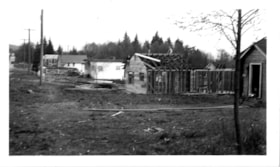
House under construction on Winch Street
https://search.heritageburnaby.ca/link/museumdescription15061
- Repository
- Burnaby Village Museum
- Date
- 16 Apr. 1948
- Collection/Fonds
- Elmer Wilson Martin fonds
- Description Level
- Item
- Physical Description
- 1 photograph : b&w ; 7 x 11.5 cm
- Scope and Content
- Photograph of duplex that is under construction at 6650 Winch Street in Burnaby. Wilbert "Bert", Elmer and William Martin are on top of the roof of the house that is under construction. Other houses are visible along the street.
- Repository
- Burnaby Village Museum
- Collection/Fonds
- Elmer Wilson Martin fonds
- Description Level
- Item
- Physical Description
- 1 photograph : b&w ; 7 x 11.5 cm
- Scope and Content
- Photograph of duplex that is under construction at 6650 Winch Street in Burnaby. Wilbert "Bert", Elmer and William Martin are on top of the roof of the house that is under construction. Other houses are visible along the street.
- Subjects
- Buildings - Residential - Houses
- Geographic Access
- Winch Street
- Street Address
- 6650 Winch Street
- Accession Code
- BV019.37.36
- Access Restriction
- No restrictions
- Reproduction Restriction
- No known restrictions
- Date
- 16 Apr. 1948
- Media Type
- Photograph
- Historic Neighbourhood
- Lochdale (Historic Neighbourhood)
- Planning Study Area
- Lochdale Area
- Scan Resolution
- 600
- Scan Date
- February 4, 2021
- Scale
- 100
- Notes
- Title based on contents of photograph
- Note in blue ink on verso of photograph reads: "Starting the Duplex / 6650 Winch St / April 16th 1948 / Bert, Elmer & Dad, on the roof"
- Stamp in black ink on verso of photograph reads: "629"
Images

![Construction of Martin's Auto Villa, [1946] thumbnail](/media/hpo/_Data/_BVM_Images/2019/2019_0037_0021_001.jpg?width=280)
Construction of Martin's Auto Villa
https://search.heritageburnaby.ca/link/museumdescription15046
- Repository
- Burnaby Village Museum
- Date
- [1946]
- Collection/Fonds
- Elmer Wilson Martin fonds
- Description Level
- Item
- Physical Description
- 1 photograph : b&w ; 7 x 11.5 cm
- Scope and Content
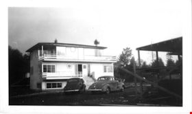
- Photograph of Elmer Wilson Martin (right) standing with an unidentified man outside of Martin's Auto Villa which is under construction at 6604 Hastings Street, Burnaby (after 1950 - 6574 Hastings Street).
- Repository
- Burnaby Village Museum
- Collection/Fonds
- Elmer Wilson Martin fonds
- Description Level
- Item
- Physical Description
- 1 photograph : b&w ; 7 x 11.5 cm
- Scope and Content
- Photograph of Elmer Wilson Martin (right) standing with an unidentified man outside of Martin's Auto Villa which is under construction at 6604 Hastings Street, Burnaby (after 1950 - 6574 Hastings Street).
- Subjects
- Construction
- Geographic Access
- Hastings Street
- Street Address
- 6574 Hastings Street
- Accession Code
- BV019.37.21
- Access Restriction
- No restrictions
- Reproduction Restriction
- No known restrictions
- Date
- [1946]
- Media Type
- Photograph
- Historic Neighbourhood
- Lochdale (Historic Neighbourhood)
- Planning Study Area
- Lochdale Area
- Scan Resolution
- 600
- Scan Date
- February 4, 2021
- Scale
- 100
- Notes
- Title based on contents of photograph
- Note in blue ink on verso of photograph reads: "Right Mr. E.W. Martin / P.Eng"
- Stamp on verso of photograph reads: "663"
Images
![Construction of Martin's Auto Villa, [1946] thumbnail](/media/hpo/_Data/_BVM_Images/2019/2019_0037_0021_001.jpg)
Martin's auto villa
https://search.heritageburnaby.ca/link/museumdescription15048
- Repository
- Burnaby Village Museum
- Date
- 5 Oct. 1946
- Collection/Fonds
- Elmer Wilson Martin fonds
- Description Level
- Item
- Physical Description
- 1 photograph : b&w ; 7 x 11.5 cm
- Scope and Content
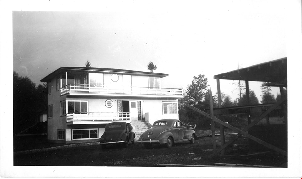
- Photograph of two cars parked outside of Martin's Auto Villa at 6604 Hastings Street (after 1950 - 6574 Hastings Street). Framework of a building is visible to the right and appears to be under construction.
- Repository
- Burnaby Village Museum
- Collection/Fonds
- Elmer Wilson Martin fonds
- Description Level
- Item
- Physical Description
- 1 photograph : b&w ; 7 x 11.5 cm
- Scope and Content
- Photograph of two cars parked outside of Martin's Auto Villa at 6604 Hastings Street (after 1950 - 6574 Hastings Street). Framework of a building is visible to the right and appears to be under construction.
- Subjects
- Construction
- Geographic Access
- Hastings Street
- Street Address
- 6574 Hastings Street
- Accession Code
- BV019.37.22
- Access Restriction
- No restrictions
- Reproduction Restriction
- No known restrictions
- Date
- 5 Oct. 1946
- Media Type
- Photograph
- Historic Neighbourhood
- Lochdale (Historic Neighbourhood)
- Planning Study Area
- Lochdale Area
- Scan Resolution
- 600
- Scan Date
- February 4, 2021
- Scale
- 100
- Notes
- Title based on contents of photograph
- Note in black ink on verso of photograph reads: "Oct. 5th 1946"
- Stamp on verso of photograph reads: "992"
Images
Martin's Auto Villa
https://search.heritageburnaby.ca/link/museumdescription15062
- Repository
- Burnaby Village Museum
- Date
- 5 Oct. 1946
- Collection/Fonds
- Elmer Wilson Martin fonds
- Description Level
- Item
- Physical Description
- 1 photograph : b&w ; 7 x 11.5 cm
- Scope and Content
- Photograph of Martin's Auto Villa on Hastings Street. Two cars are parked outside. A building in the foreground of the photograph appears to be under construction.
- Repository
- Burnaby Village Museum
- Collection/Fonds
- Elmer Wilson Martin fonds
- Description Level
- Item
- Physical Description
- 1 photograph : b&w ; 7 x 11.5 cm
- Scope and Content
- Photograph of Martin's Auto Villa on Hastings Street. Two cars are parked outside. A building in the foreground of the photograph appears to be under construction.
- Geographic Access
- Hastings Street
- Street Address
- 6574 Hastings Street
- Accession Code
- BV019.37.37
- Access Restriction
- No restrictions
- Reproduction Restriction
- No known restrictions
- Date
- 5 Oct. 1946
- Media Type
- Photograph
- Historic Neighbourhood
- Lochdale (Historic Neighbourhood)
- Planning Study Area
- Lochdale Area
- Scan Resolution
- 600
- Scan Date
- February 4, 2021
- Scale
- 100
- Notes
- Title based on contents of photograph
- Note in blue ink on verso of photograph reads: "Oct. 5th 1946"
- Stamp in black ink on verso of photograph reads: "992"
Images

Bus Service Organizing Committee
https://search.heritageburnaby.ca/link/museumdescription2975
- Repository
- Burnaby Village Museum
- Date
- August 1941
- Collection/Fonds
- Burnaby Village Museum Photograph collection
- Description Level
- Item
- Physical Description
- 1 photograph : b&w hand-tinted to col. ; 17.5 x 24.5 cm, mounted on card 28 x 35.5 cm
- Scope and Content
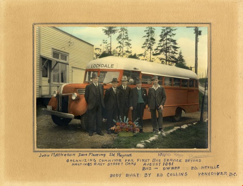
- Photograph of John Matheson, Dave Fleming, Sid Playfoot, unidentified and Harold Keys in suits and hats, standing in front of a red bus with a sign over the windshield that reads, "LOCHDALE". These men made up the organizing committee for the first bus service that was to run beyond the route of th…
- Repository
- Burnaby Village Museum
- Collection/Fonds
- Burnaby Village Museum Photograph collection
- Description Level
- Item
- Physical Description
- 1 photograph : b&w hand-tinted to col. ; 17.5 x 24.5 cm, mounted on card 28 x 35.5 cm
- Scope and Content
- Photograph of John Matheson, Dave Fleming, Sid Playfoot, unidentified and Harold Keys in suits and hats, standing in front of a red bus with a sign over the windshield that reads, "LOCHDALE". These men made up the organizing committee for the first bus service that was to run beyond the route of the Hastings East Street cars (the Lochdale bus was built by Ed Collins and owned and operated by Ed Neville).
- Accession Code
- BV988.8.1
- Access Restriction
- No restrictions
- Reproduction Restriction
- No known restrictions
- Date
- August 1941
- Media Type
- Photograph
- Historic Neighbourhood
- Lochdale (Historic Neighbourhood)
- Scan Resolution
- 600
- Scan Date
- 1/11/2010
- Scale
- 100
- Notes
- Title based on contents of photograph
- Note in blue ink on recto of card mount reads: "John Matheson Dave Fleming Sid Playfoot HAROLD Keys/ ORGANIZING COMMITTEE FOR FIRST BUS SERVICE BEYOND/ HASTINGS EAST STREET CARS AUGUST 1941/ BUS - OWNER ED. NEVILLE/ BODY BUILT BY ED COLLINS VANCOUVER B.C."
- Note in pencil on recto of card mount reads: "PINKERTON"
Images
![Interior of Lochdale Hall, [between 1935 and 1940] thumbnail](/media/hpo/_Data/_BVM_Images/2000/200500200007.jpg?width=280)
Interior of Lochdale Hall
https://search.heritageburnaby.ca/link/museumdescription1881
- Repository
- Burnaby Village Museum
- Date
- [between 1935 and 1940]
- Collection/Fonds
- Harry Royle fonds
- Description Level
- Item
- Physical Description
- 1 photograph : sepia ; 16 x 24 cm
- Scope and Content
- Photograph of the interior of Lochdale Hall. Streamers are hanging from the ceiling and the walls, and numerous people are seated at three long tables. The occasion is unidentified.
- Repository
- Burnaby Village Museum
- Collection/Fonds
- Harry Royle fonds
- Description Level
- Item
- Physical Description
- 1 photograph : sepia ; 16 x 24 cm
- Scope and Content
- Photograph of the interior of Lochdale Hall. Streamers are hanging from the ceiling and the walls, and numerous people are seated at three long tables. The occasion is unidentified.
- Names
- Lochdale Community Hall
- Accession Code
- BV005.20.7
- Access Restriction
- No restrictions
- Reproduction Restriction
- No known restrictions
- Date
- [between 1935 and 1940]
- Media Type
- Photograph
- Historic Neighbourhood
- Lochdale (Historic Neighbourhood)
- Scan Resolution
- 600
- Scan Date
- 1/12/2010
- Scale
- 100
- Notes
- Title based on contents of photograph
Images
![Interior of Lochdale Hall, [between 1935 and 1940] thumbnail](/media/hpo/_Data/_BVM_Images/2000/200500200007.jpg)
![Dow General Store, [193-] thumbnail](/media/hpo/_Data/_BVM_Images/1976/1976_0062_0001_001.jpg?width=280)
Dow General Store
https://search.heritageburnaby.ca/link/museumdescription741
- Repository
- Burnaby Village Museum
- Date
- [193-]
- Collection/Fonds
- Burnaby Village Museum Photograph collection
- Description Level
- Item
- Physical Description
- 1 photograph : b&w ; 8.89 x 14.61 cm
- Scope and Content
- Photograph of a store with a large Coca Cola sign hanging by the second floor windows. The awning has lettering: "Ice Cream - Soft Drinks." By the door, there is a sign that reads "Post Office / Public Telephone / Box Cigars." On the display window, an advertisement sign for "Salada Tea" can be s…
- Repository
- Burnaby Village Museum
- Collection/Fonds
- Burnaby Village Museum Photograph collection
- Description Level
- Item
- Physical Description
- 1 photograph : b&w ; 8.89 x 14.61 cm
- Material Details
- An annotation in pencil is written on the back of the photograph
- Scope and Content
- Photograph of a store with a large Coca Cola sign hanging by the second floor windows. The awning has lettering: "Ice Cream - Soft Drinks." By the door, there is a sign that reads "Post Office / Public Telephone / Box Cigars." On the display window, an advertisement sign for "Salada Tea" can be seen. By the steps leading into the store, there is a large advertisement sign that reads "Wilson's Bachelor Cigar 10c." In front of the store is a paved road.
- Geographic Access
- Hastings Street
- Street Address
- 6669 Hastings Street
- Accession Code
- HV976.62.1
- Access Restriction
- No restrictions
- Reproduction Restriction
- No known restrictions
- Date
- [193-]
- Media Type
- Photograph
- Historic Neighbourhood
- Lochdale (Historic Neighbourhood)
- Scan Resolution
- 600
- Scan Date
- 2023-06-20
- Notes
- Title based on contents of photograph
- An annotation on the back of the photograph reads, "Dow General Store / Sperling & Hastings Approx / 1930's." The 1937 directory lists the name as "Dow's General Store" and the address as 6669 Hastings Street.
Images
![Dow General Store, [193-] thumbnail](/media/hpo/_Data/_BVM_Images/1976/1976_0062_0001_001.jpg)

Municipality of Burnaby - Volume XV and Volume XVIII
https://search.heritageburnaby.ca/link/museumdescription8680
- Repository
- Burnaby Village Museum
- Date
- May 1927
- Collection/Fonds
- Burnaby Village Museum Map collection
- Description Level
- File
- Physical Description
- 4 plans on 4 sheets : col. lithographic prints ; 63.5 x 53.5 cm folded to 53 x 31.5 cm
- Scope and Content
- File consists of four pages of plans removed from a bound book containing a series of fire insurance plans of the Municipality of Burnaby. The first two pages are numbered "A" and "B" and are key plans from "GREATER VANCOUVER B.C. / VOLUME XV / Surveyed _ May 1927 / MUNICIPALITY OF / BURNABY", "PLA…
- Repository
- Burnaby Village Museum
- Collection/Fonds
- Burnaby Village Museum Map collection
- Description Level
- File
- Physical Description
- 4 plans on 4 sheets : col. lithographic prints ; 63.5 x 53.5 cm folded to 53 x 31.5 cm
- Material Details
- Scales [1:1200] and [1:6000]
- Scope and Content
- File consists of four pages of plans removed from a bound book containing a series of fire insurance plans of the Municipality of Burnaby. The first two pages are numbered "A" and "B" and are key plans from "GREATER VANCOUVER B.C. / VOLUME XV / Surveyed _ May 1927 / MUNICIPALITY OF / BURNABY", "PLAN DEPT. FIRE BRANCH _ B.C. INSURANCE UNDERWRITERS ASSN.". Key Plan "B" covers plans: 1505; 1506; 1512 to 1516; 1540 to 1544; 1550 to 1557 and District Lots: 129 to 132; 135 to 138; 205 to 208 and 215 to 218. Key Plan "A" covers plans: 1501 to 1504; 1507 to 1511; 1517 to 1525; 1531 to 1539; 1545 to 1550 and District Lots: 116 to 127 and 186 to 189. Plan "1806" is part of "GREATER VANCOUVER B.C. / VOLUME XVIII / Municipality of Burnaby / May, 1927" and covers District Lot 153. Plan "1807" is from "GREATER VANCOUVER B.C. / VOLUME XVIII / Municipality of Burnaby / May, 1927" and covers District Lots: 99,149 and 152.
- Responsibility
- British Columbia Underwriters' Association
- Accession Code
- HV972.111.2
- Access Restriction
- No restrictions
- Reproduction Restriction
- May be restricted by third party rights
- Date
- May 1927
- Media Type
- Cartographic Material
- Historic Neighbourhood
- Vancouver Heights (Historic Neighbourhood)
- Lochdale (Historic Neighbourhood)
- Capitol Hill (Historic Neighbourhood)
- Central Park (Historic Neighbourhood)
- Alta Vista (Historic Neighbourhood)
- Planning Study Area
- Burnaby Heights Area
- Sperling-Broadway Area
- Lochdale Area
- Parkcrest-Aubrey Area
- Westridge Area
- Willingdon Heights Area
- Capitol Hill Area
- Maywood Area
- Marlborough Area
- Scan Resolution
- 400
- Scan Date
- 2021-11-18
- Notes
- Title based on content of plans
- Scales are measured 1 inch = 100 feet and 1 inch = 500 feet
- See also BV987.1.70d for revised versions of plans
Zoomable Images


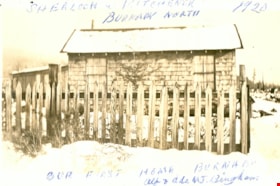
First Burnaby home of Alfred and Ade Bingham
https://search.heritageburnaby.ca/link/museumdescription15
- Repository
- Burnaby Village Museum
- Date
- 1920
- Collection/Fonds
- Burnaby Village Museum Photograph collection
- Description Level
- Item
- Physical Description
- 1 photograph : b&w ; 7.0 x 11.4 cm
- Scope and Content
- Photograph of a snow-covered house with a picket fence around it. This is the first home of Alfred and Ade Bingham, located at Sherlock Avenue and Kitchener Street. An annotation at the top of the photo reads, "Sherlock and Kitchener / Burnaby North / 1920." An annotation at the bottom of the pho…
- Repository
- Burnaby Village Museum
- Collection/Fonds
- Burnaby Village Museum Photograph collection
- Description Level
- Item
- Physical Description
- 1 photograph : b&w ; 7.0 x 11.4 cm
- Scope and Content
- Photograph of a snow-covered house with a picket fence around it. This is the first home of Alfred and Ade Bingham, located at Sherlock Avenue and Kitchener Street. An annotation at the top of the photo reads, "Sherlock and Kitchener / Burnaby North / 1920." An annotation at the bottom of the photograph reads, "Our First Home Burnaby / Alf and Ade MJ. Bingham."
- Names
- Bingham, Alfred "Alf"
- Geographic Access
- Sherlock Avenue
- Kitchener Street
- Accession Code
- HV971.12.83
- Access Restriction
- No restrictions
- Reproduction Restriction
- No known restrictions
- Date
- 1920
- Media Type
- Photograph
- Historic Neighbourhood
- Lochdale (Historic Neighbourhood)
- Planning Study Area
- Lochdale Area
- Scan Resolution
- 600
- Scan Date
- 2023-03-21
- Notes
- Title based on contents of photograph
Images


Sperling Avenue School site
https://search.heritageburnaby.ca/link/museumdescription11137
- Repository
- Burnaby Village Museum
- Date
- March 8, 1915
- Collection/Fonds
- Ronald G. Scobbie collection
- Description Level
- Item
- Physical Description
- 1 survey plan : blueprint on paper ; 56 x 54 cm
- Scope and Content
- Survey plan of "Sperling Avenue School Site / Burnaby Municipality" "Being a 4.11 acre portion of the south half of Block 7 of subd. part of Lot 131, Grroup 1" "New Westminster District".
- Repository
- Burnaby Village Museum
- Collection/Fonds
- Ronald G. Scobbie collection
- Description Level
- Item
- Physical Description
- 1 survey plan : blueprint on paper ; 56 x 54 cm
- Material Details
- Scale 40 feet = 1 inch
- Scope and Content
- Survey plan of "Sperling Avenue School Site / Burnaby Municipality" "Being a 4.11 acre portion of the south half of Block 7 of subd. part of Lot 131, Grroup 1" "New Westminster District".
- Creator
- McGugan, Donald Johnston
- Subjects
- Buildings - Schools
- Names
- Sperling Avenue School
- Responsibility
- Burnett & McGugan, Engineers and Surveyors
- Geographic Access
- Sperling Avenue
- Street Address
- 2200 Sperling Avenue
- Accession Code
- BV003.83.16
- Access Restriction
- No restrictions
- Reproduction Restriction
- No known restrictions
- Date
- March 8, 1915
- Media Type
- Cartographic Material
- Historic Neighbourhood
- Lochdale (Historic Neighbourhood)
- Planning Study Area
- Sperling-Broadway Area
- Scan Resolution
- 440
- Scan Date
- 22-Dec-2020
- Scale
- 100
- Notes
- Title based on contents of plan
- handwritten on back, "1748"
- Oath on plan reads: "I, D.G. McGugan..." "...person- ally superintend the survey..." "...completed on the 8th day of March 1915"; signed by D.J. McGugan, notarized by "R.E. Chapman", sworn "...12th day of April 1915" "Burnett and McGugan" "B.C. Land Surveyors Etc. New Westminster, B.C..";
Images

![Logging Camp, [1903] thumbnail](/media/hpo/_Data/_BVM_Images/1977/1977_0140_0004_001.jpg?width=280)
Logging Camp
https://search.heritageburnaby.ca/link/museumdescription639
- Repository
- Burnaby Village Museum
- Date
- [1903]
- Collection/Fonds
- Burnaby Village Museum Photograph collection
- Description Level
- Item
- Physical Description
- 1 photograph : b&w ; 11.5 x 17.5 cm mounted on card 18.5 x 23 cm
- Scope and Content
- Photograph of a crew of loggers sitting and standing in front of their cabins at a logging camp at Broadway, west of Sperling Avenue. Robert Pontifex is standing fourth from the right.
- Repository
- Burnaby Village Museum
- Collection/Fonds
- Burnaby Village Museum Photograph collection
- Description Level
- Item
- Physical Description
- 1 photograph : b&w ; 11.5 x 17.5 cm mounted on card 18.5 x 23 cm
- Scope and Content
- Photograph of a crew of loggers sitting and standing in front of their cabins at a logging camp at Broadway, west of Sperling Avenue. Robert Pontifex is standing fourth from the right.
- Subjects
- Occupations - Lumberjacks
- Names
- Pontifex, Robert
- Geographic Access
- Broadway
- Sperling Avenue
- Accession Code
- HV977.140.4
- Access Restriction
- No restrictions
- Date
- [1903]
- Media Type
- Photograph
- Historic Neighbourhood
- Lochdale (Historic Neighbourhood)
- Planning Study Area
- Sperling-Broadway Area
- Scan Resolution
- 600
- Scan Date
- 2023-07-25
- Notes
- Title based on contents of photograph
- Handwritten notes on verso of card mount read: "Broadway West of Sperling Ave / 1903" and "Mr. Doug Lorky."
Images
![Logging Camp, [1903] thumbnail](/media/hpo/_Data/_BVM_Images/1977/1977_0140_0004_001.jpg)
