Narrow Results By
Subject
- Agriculture - Crops 1
- Buildings - Residential - Houses 5
- Construction - Road Construction 1
- Construction Tools and Equipment 1
- Geographic Features - Fields 1
- Geographic Features - Lakes and Ponds 2
- Geographic Features - Roads 4
- Industries - Forestry 1
- Industries - Logging/lumber 1
- Land Clearing 15
- Natural Phenomena - Snow 1
- Occupations - Farmers 1

Barnet Wagon Road
https://search.heritageburnaby.ca/link/archivedescription38306
- Repository
- City of Burnaby Archives
- Date
- June 1903 (date of original), copied ca. 1990
- Collection/Fonds
- Burnaby Historical Society fonds
- Description Level
- Item
- Physical Description
- 1 photograph : b&w ; 10 x 15 cm print
- Scope and Content
- Photograph of the Barnet Wagon Road looking west from Sperling Avenue.
- Repository
- City of Burnaby Archives
- Date
- June 1903 (date of original), copied ca. 1990
- Collection/Fonds
- Burnaby Historical Society fonds
- Subseries
- Photographs subseries
- Physical Description
- 1 photograph : b&w ; 10 x 15 cm print
- Description Level
- Item
- Record No.
- 403-001
- Access Restriction
- No restrictions
- Reproduction Restriction
- No known restrictions
- Accession Number
- BHS2007-04
- Scope and Content
- Photograph of the Barnet Wagon Road looking west from Sperling Avenue.
- Subjects
- Land Clearing
- Geographic Features - Roads
- Media Type
- Photograph
- Notes
- Title based on contents of photograph
- Geographic Access
- Barnet Road
- Sperling Avenue
- Historic Neighbourhood
- Lochdale (Historic Neighbourhood)
- Planning Study Area
- Westridge Area
Images


Barnet Wagon Road
https://search.heritageburnaby.ca/link/archivedescription38307
- Repository
- City of Burnaby Archives
- Date
- June 1903 (date of original), copied ca. 1990
- Collection/Fonds
- Burnaby Historical Society fonds
- Description Level
- Item
- Physical Description
- 1 photograph : b&w ; 10 x 15 cm print
- Scope and Content
- Photograph of the Barnet Wagon Road looking east, near Barnet and Hastings.
- Repository
- City of Burnaby Archives
- Date
- June 1903 (date of original), copied ca. 1990
- Collection/Fonds
- Burnaby Historical Society fonds
- Subseries
- Photographs subseries
- Physical Description
- 1 photograph : b&w ; 10 x 15 cm print
- Description Level
- Item
- Record No.
- 403-002
- Access Restriction
- No restrictions
- Reproduction Restriction
- No known restrictions
- Accession Number
- BHS2007-04
- Scope and Content
- Photograph of the Barnet Wagon Road looking east, near Barnet and Hastings.
- Subjects
- Land Clearing
- Geographic Features - Roads
- Media Type
- Photograph
- Notes
- Title based on contents of photograph
- Geographic Access
- Barnet Road
- Hastings Street
- Historic Neighbourhood
- Lochdale (Historic Neighbourhood)
- Planning Study Area
- Westridge Area
Images

![Boat on the water, [190-] thumbnail](/media/hpo/_Data/_BVM_Images/1973/1973_0050_0073_001.jpg?width=280)
Boat on the water
https://search.heritageburnaby.ca/link/museumdescription3065
- Repository
- Burnaby Village Museum
- Date
- [190-]
- Collection/Fonds
- Burnaby Village Museum Photograph collection
- Description Level
- Item
- Physical Description
- 1 photograph : b&w glass negative ; 12.6 x 17.8 cm
- Scope and Content
- Photograph of a single boat floating on a stretch of water. No land is visible. The name on the side of the boat is "Chinook." The location and identity of the boat are undetermined.
- Repository
- Burnaby Village Museum
- Collection/Fonds
- Burnaby Village Museum Photograph collection
- Description Level
- Item
- Physical Description
- 1 photograph : b&w glass negative ; 12.6 x 17.8 cm
- Scope and Content
- Photograph of a single boat floating on a stretch of water. No land is visible. The name on the side of the boat is "Chinook." The location and identity of the boat are undetermined.
- Subjects
- Transportation - Boats
- Accession Code
- HV973.50.73
- Access Restriction
- No restrictions
- Reproduction Restriction
- May be restricted by third party rights
- Date
- [190-]
- Media Type
- Photograph
- Scan Resolution
- 600
- Scan Date
- 2023-05-16
- Notes
- Title based on contents of photograph
- 1 b&w copy print accompanying
Images
![Boat on the water, [190-] thumbnail](/media/hpo/_Data/_BVM_Images/1973/1973_0050_0073_001.jpg)

Claude Hill beside a large felled tree
https://search.heritageburnaby.ca/link/archivedescription39517
- Repository
- City of Burnaby Archives
- Date
- 1900
- Collection/Fonds
- Peers Family and Hill Family fonds
- Description Level
- Item
- Physical Description
- 1 photograph : b&w ; 10.5 x 15 cm on page 21.5 x 28 cm (pasted in album)
- Scope and Content
- Photograph of Louis Claude Hill standing by a ladder placed in a ditch. The ladder is leaning against a giant tree upturned by the roots. The ditch appears to be created from uprooting the tree. There is a pile of firewood visible to the right, and a barn to the left in the distance.
- Repository
- City of Burnaby Archives
- Date
- 1900
- Collection/Fonds
- Peers Family and Hill Family fonds
- Physical Description
- 1 photograph : b&w ; 10.5 x 15 cm on page 21.5 x 28 cm (pasted in album)
- Description Level
- Item
- Record No.
- 477-836
- Access Restriction
- No restrictions
- Reproduction Restriction
- No known restrictions
- Accession Number
- 2007-12
- Scope and Content
- Photograph of Louis Claude Hill standing by a ladder placed in a ditch. The ladder is leaning against a giant tree upturned by the roots. The ditch appears to be created from uprooting the tree. There is a pile of firewood visible to the right, and a barn to the left in the distance.
- Subjects
- Land Clearing
- Plants - Trees
- Media Type
- Photograph
- Notes
- Title based on contents of photograph
- Geographic Access
- Deer Lake Avenue
- Historic Neighbourhood
- Burnaby Lake (Historic Neighbourhood)
Images

, copied 1978 thumbnail](/media/hpo/_Data/_BVM_Images/1977/197800010016.jpg?width=280)
Cleared land
https://search.heritageburnaby.ca/link/museumdescription462
- Repository
- Burnaby Village Museum
- Date
- [190-](date of original), copied 1978
- Collection/Fonds
- Burnaby Village Museum Photograph collection
- Description Level
- Item
- Physical Description
- 1 photograph : b&w ; 20.2 x 25.2 cm print
- Scope and Content
- Photograph of the cleared land which appears to be the Sprott family property. There are stumps and felled trees on the lot. Across a small dirt road and behind a wooden fence, the Haszard house is visible to the extreme right of the photograph.
- Repository
- Burnaby Village Museum
- Collection/Fonds
- Burnaby Village Museum Photograph collection
- Description Level
- Item
- Physical Description
- 1 photograph : b&w ; 20.2 x 25.2 cm print
- Scope and Content
- Photograph of the cleared land which appears to be the Sprott family property. There are stumps and felled trees on the lot. Across a small dirt road and behind a wooden fence, the Haszard house is visible to the extreme right of the photograph.
- Subjects
- Land Clearing
- Plants - Trees
- Geographic Access
- Canada Way
- Accession Code
- HV978.1.16
- Access Restriction
- No restrictions
- Reproduction Restriction
- No known restrictions
- Date
- [190-](date of original), copied 1978
- Media Type
- Photograph
- Historic Neighbourhood
- Burnaby Lake (Historic Neighbourhood)
- Scan Resolution
- 600
- Scan Date
- 2023-08-01
- Notes
- Title based on contents of photograph
Images
, copied 1978 thumbnail](/media/hpo/_Data/_BVM_Images/1977/197800010016.jpg)
![Clearing Douglas Road, [190-?] (date of original), copied 1977 thumbnail](/media/hpo/_Data/_BVM_Images/1977/1977_0099_0002_001.jpg?width=280)
Clearing Douglas Road
https://search.heritageburnaby.ca/link/museumdescription560
- Repository
- Burnaby Village Museum
- Date
- [190-?] (date of original), copied 1977
- Collection/Fonds
- Burnaby Village Museum Photograph collection
- Description Level
- Item
- Physical Description
- 1 photograph : b&w ; 20.2 x 25.2 cm print
- Scope and Content
- Photograph of men in work clothes clearing Doulgas Road. A group of men to the right side of the photograph have shovels in their hands and are clearing rocks from the road. There is a small girl in a blouse and skirt standing beside two horses pulling a cart. Behind her is a group of men in wor…
- Repository
- Burnaby Village Museum
- Collection/Fonds
- Burnaby Village Museum Photograph collection
- Description Level
- Item
- Physical Description
- 1 photograph : b&w ; 20.2 x 25.2 cm print
- Scope and Content
- Photograph of men in work clothes clearing Doulgas Road. A group of men to the right side of the photograph have shovels in their hands and are clearing rocks from the road. There is a small girl in a blouse and skirt standing beside two horses pulling a cart. Behind her is a group of men in work clothes as well. There is fenced land to the right of the photograph, and electric power poles and trees line both sides of the road. The accession register and inscription on the photograph identify this as Douglas Road (later renamed in part Canada Way). An annotation on the back of the photo reads: "Working on Douglas Road on hill above Burnaby Lake. No Date."
- Geographic Access
- Douglas Road
- Canada Way
- Accession Code
- HV977.99.2
- Access Restriction
- No restrictions
- Reproduction Restriction
- May be restricted by third party rights
- Date
- [190-?] (date of original), copied 1977
- Media Type
- Photograph
- Historic Neighbourhood
- Burnaby Lake (Historic Neighbourhood)
- Scan Resolution
- 600
- Scan Date
- 2023-07-11
- Notes
- Title based on contents of photograph
Images
![Clearing Douglas Road, [190-?] (date of original), copied 1977 thumbnail](/media/hpo/_Data/_BVM_Images/1977/1977_0099_0002_001.jpg)
![Dallamore Family Home, [1900] (date of original), copied 1986 thumbnail](/media/hpo/_Data/_Archives_Images/_Unrestricted/204/204-130.jpg?width=280)
Dallamore Family Home
https://search.heritageburnaby.ca/link/archivedescription35273
- Repository
- City of Burnaby Archives
- Date
- [1900] (date of original), copied 1986
- Collection/Fonds
- Burnaby Historical Society fonds
- Description Level
- Item
- Physical Description
- 1 photograph : b&w ; 12.7 x 17.8 cm print
- Scope and Content
- Photograph of the Dallamore family home on Silver Avenue near the B.C. Electric interurban tracks. Grace Dallamore's grandparents, the Harmers, and her parents, the Dallamores, owned this entire block of land. This house was built ca. 1896 by F.L. Harmer, a carpenter who settled in Burnaby in 189…
- Repository
- City of Burnaby Archives
- Date
- [1900] (date of original), copied 1986
- Collection/Fonds
- Burnaby Historical Society fonds
- Subseries
- Pioneer Tales subseries
- Physical Description
- 1 photograph : b&w ; 12.7 x 17.8 cm print
- Description Level
- Item
- Record No.
- 204-130
- Access Restriction
- No restrictions
- Reproduction Restriction
- No known restrictions
- Accession Number
- BHS1988-03
- Scope and Content
- Photograph of the Dallamore family home on Silver Avenue near the B.C. Electric interurban tracks. Grace Dallamore's grandparents, the Harmers, and her parents, the Dallamores, owned this entire block of land. This house was built ca. 1896 by F.L. Harmer, a carpenter who settled in Burnaby in 1894.
- Media Type
- Photograph
- Notes
- Title based on contents of photograph
- Geographic Access
- Silver Avenue
- Street Address
- 6380 Silver Avenue
- Historic Neighbourhood
- Central Park (Historic Neighbourhood)
- Planning Study Area
- Maywood Area
Images
![Dallamore Family Home, [1900] (date of original), copied 1986 thumbnail](/media/hpo/_Data/_Archives_Images/_Unrestricted/204/204-130.jpg)
Esther Love Stanley fonds
https://search.heritageburnaby.ca/link/museumdescription18841
- Repository
- Burnaby Village Museum
- Date
- 1896-[2015] (dates of originals)
- Collection/Fonds
- Esther Love Stanley fonds
- Description Level
- Fonds
- Physical Description
- 2 photograph albums + 3 photographs + 128 photographs (tiffs & jpgs) + 1 cm textual records
- Scope and Content
- Fonds consists of original photograph albums created by Esther (Love) Stanley as well as a collection of digital reproductions of photographs, documents and newspaper clippings pertaining to the Love, Stanley and Shankie families.
- Repository
- Burnaby Village Museum
- Collection/Fonds
- Esther Love Stanley fonds
- Description Level
- Fonds
- Physical Description
- 2 photograph albums + 3 photographs + 128 photographs (tiffs & jpgs) + 1 cm textual records
- Scope and Content
- Fonds consists of original photograph albums created by Esther (Love) Stanley as well as a collection of digital reproductions of photographs, documents and newspaper clippings pertaining to the Love, Stanley and Shankie families.
- History
- Esther Love Stanley was born in Burnaby in 1896 to parents Jesse Love (1847-1928) and Martha Leonard (1858-1920). Esther's father, Jesse Love was born in Swindon, England and left England to work on a dairy farm in the Toronto area. While working on the farm in Toronto, Jesse met Martha Leonard and they married in 1879. While living in Toronto, Jesse and Martha had two children, George (1880-1974) and Annie Elizabeth (1881-1957). About one year after Annie was born, the Love family moved to North Dakota to grow wheat. While living there, they had two more children, Henry (1883-1956) and Edith Minnie (1885-1976). The family decided to move further west after hearing about the fairer weather conditions from Martha’s father, George Leonard, who had settled in Vancouver in 1885. On May 23, 1887, Jesse, Martha and their four children arrived in Vancouver after travelling across Canada from Winnipeg on the first transcontinental train. Soon after their fifth child, Thomas Robert (1887-1918) was born, the family moved to Lulu Island in Richmond where they lived growing vegetables and selling them to Vancouver hotels. While living and farming on Lulu island, the couple had two more children Martha (Dot or Dorothy) (1889-1972) and Sarah Marie (1892-1978). In October 1893, Jesse Love purchased land in District Lot 25, Burnaby and built a house between 1893 and 1894. A road was constructed and named Cumberland in 1905 and the address for the Love home was 1390 Cumberland Road (after 1960- 7651 Cumberland). While living in the house, Jesse and Martha had four more children, Phoebe Leonard (1894-1991), Esther (1896-1991), John Leonard (1899-1978) and Hannah Victoria (also known as Girlie) (1902-1976). Frank Charles “Stan” Stanley was born in London, England in 1891. Frank “Stan” Stanley is the youngest son of John Stanley and Mary (Conquest) Stanley. John and Mary had eleven children: Conquest John “Con”, George, Alice, Mary, Nelly, Mabel Annie, Percy William, Henry James, Ada Elizabeth, Arthur Ewart and Frank Charles. In 1912, Frank Charles Stanley immigrated to Canada. Frank Stanley served in the 29th Battalion (nicknamed Tobin's Tigers) during the First World War. He received a Military Medal for bravery while serving as lieutenant. Esther Love and Frank “Stan” Stanley maintained a relationship through letter writing during the First World War and in 1921 after he returned, they were married at St. Alban’s Church in Burnaby. Frank and Esther Stanley (nee Love) had four children, Mary Frances (Pearson) (d. 1986), Ina Esther (Shankie) (1924-2017), Frank Conquest and Joyce (Warner). Frank Charles “Stan” Stanley ran a service station on St. John's Street in Port Moody for many years and also served as mayor of Port Moody in the 1940s. Frank Charles Stanley died in 1975 and Esther Love Stanley died in 1991. In 1947, Ina Esther Stanley married Thomas Ramsay “Ram” Shankie (1920-1996). Ina and Thomas Ramsay Shankie had four children; David Andre Shankie (b. 1951), Linda Lorraine Shankie (Hanlon), Susan Lesley Shankie (Weston) and Kathryn Louise Shankie. The family lived at 5351 Kalyk Avenue in Burnaby (later 3676 Kalyk Avenue). Thomas Ramsay Shankie is the son of Thomas Shankie (1872-1959) and Bertha Janet Shankie (nee Gray) (1891-1965). Thomas Shankie (Sr.) immigrated to Canada from Scotland in 1905. In 1919 Thomas Shankie married Bertha Janet Gray at Henderson Presbyterian Church in West Burnaby. Thomas was the church organist and choir master of the church. Once married, the couple moved to a house located at 3718 Barker Avenue (later became 5515 Barker Avenue). Thomas and Bertha Shankie had two children, Thomas Ramsay Shankie (1920-1996) and Janet Isabella Shankie (Bower) (1923-2014). Around the age of 46 years, Thomas Shankie joined a gym and bought a bicycle to improve his health. By 1955 at the age of 83 years, Thomas Shankie had logged over two hundred thousand miles since buying his first bicycle. His motto was "ride a bicycle if you want to stay young and live long". Thomas also competed in many cycling races. Janet Isabella Shankie Bower (1923-2014) married Charles Franklin "Frank" Bower (1914-2004) in 1947. Janet and Frank Bower had two children; Gordon Franklin Bower (1951-2003) and Janet (Flintroy).
- Creator
- Stanley, Esther Love
- Accession Code
- BV015.40
- BV016.43
- BV022.32
- Access Restriction
- No restrictions
- Reproduction Restriction
- No known restrictions
- Date
- 1896-[2015] (dates of originals)
- Media Type
- Photograph
- Arrangement
- Creator as well as descendants maintained original photograph albums along with digital copies of original family records. A selection of digital copies and originals were preserved in the order in which they were maintained and are reflected in the archival descriptions. When original photograph albums were acquired in 2022, some digital surrogates were deaccesioned.
- Notes
- Title based on contents of fonds
- See also Love family fonds
- Items of ephemera are described as artifacts in the Burnaby Village Museum artifact collection.
Ettinger family subseries
https://search.heritageburnaby.ca/link/archivedescription36
- Repository
- City of Burnaby Archives
- Date
- 1898-1971
- Collection/Fonds
- Burnaby Historical Society fonds
- Description Level
- Subseries
- Physical Description
- Textual records and photographs
- Scope and Content
- Subseries consists of photographs, newspaper clippings and legal documents related to the Ettinger family of Burnaby.
- Repository
- City of Burnaby Archives
- Date
- 1898-1971
- Collection/Fonds
- Burnaby Historical Society fonds
- Subseries
- Ettinger family subseries
- Physical Description
- Textual records and photographs
- Description Level
- Subseries
- Accession Number
- BHS2002-03
- Scope and Content
- Subseries consists of photographs, newspaper clippings and legal documents related to the Ettinger family of Burnaby.
- History
- James Gilmore Ettinger was born in Noel Road, Nova Scotia in 1863. He worked his way across Canada with the Canadian Pacific Railway (CPR) and landed in New Westminster in 1888. He was one of the first men who helped log the area for the settlement that is now Burnaby. With two other men, James started a brick manufacturing plant in the area of Deer Lake. In 1889, a second brick plant was started on Brickyard Road in Surrey on the bank of the Fraser River. Martha Harriet Hembrough was born in Leeds, England in 1874 and later moved to Haney. James Gilmore and Martha married in 1890 and had seven children: Evelina "Eve" (b. August 8, 1891, d. January 1, 1976); Ella May (b. ca. 1894, d. February 1983); Leonard; George William "Bill" (b. February 18, 1899, d. November 26, 1970); Stanley (b. December 27, 1901, d. March 10, 1966); Ethel (b. ca. 1904, d. December 22, 1982); and James. On May 19, 1911, the Ettingers bought parcel Lot 8, Block C sub-division 19 and 20 of DL 95 no. 556 for $350.00. Their eldest daughter, Evelina was signed over the Deed of Land for this property on April 21, 1914. In 1919, the Ettinger family was living at 1177 19th Avenue, Edmonds, Burnaby. James worked as a Road Foreman in Edmonds, and later as ward foreman for the Municipality. Ella May married Charles Morton Marshall on July 7, 1926. Evelina married Don Digby (d. October 21, 1965) on April 30, 1930. Ethel married George H. McKennell (d. June 18, 1985) on March 16, 1931. Bill worked as a Pacific Stage Lines (PSL) bus operator who “pulled” the first bus service between Vancouver and New Westminster and between Vancouver and Chilliwack in 1924. He received a number of National Safety Council non-accident awards during his career. He married Jane Wilson on July 11, 1931. James Gilmore died on June 9, 1948 at the age of 85. Martha died on February 9, 1955 at the age of 80.
- Media Type
- Textual Record
- Photograph
- Creator
- Ettinger, James Gilmore
- Notes
- Title based on contents of subseries
- PC 428, MSS147
Florence Hart Godwin fonds
https://search.heritageburnaby.ca/link/museumdescription14283
- Repository
- Burnaby Village Museum
- Date
- 1893-1923 (date of original), copied 1976
- Collection/Fonds
- Florence Hart Godwin fonds
- Description Level
- Fonds
- Physical Description
- 2 photograph albums (60 photographs)
- Scope and Content
- Fonds consists of photographic reproductions of two photograph albums. One album was owned and created by Florence Hart Godwin and the other by Florence Hart Godwin's mother, Alice Hart (nee Chapman). The albums consist of photographs of the Hart family and members of the Chapman family while they …
- Repository
- Burnaby Village Museum
- Collection/Fonds
- Florence Hart Godwin fonds
- Description Level
- Fonds
- Physical Description
- 2 photograph albums (60 photographs)
- Scope and Content
- Fonds consists of photographic reproductions of two photograph albums. One album was owned and created by Florence Hart Godwin and the other by Florence Hart Godwin's mother, Alice Hart (nee Chapman). The albums consist of photographs of the Hart family and members of the Chapman family while they had residences in New Westminster, Deer Lake and Kerrisdale along with time spent at Pitt Lake, Mayne Island, Stanley Park and Victoria. Albums are described at file level and album pages are described at item level.
- History
- Florence Elizabeth Hart Godwin was born in New Westminster in 1898 to parents, Frederick John Hart (1884- 1945) and Alice Hart (nee Chapman) (1885-1935). Alice and Frederick Hart were married in Yale in 1895 and had five children, Kingsley (1897-1916), Florence (1898-1999), Alice Fredricka “Freda” (1903-1905), Edwyna Jane (1907-1997) and Frederick John “Jack” (1908-2001). Alice Hart (nee Chapman) was the daughter of Edward Chapman and Jane Chapman (nee Isbell) born in Birmingham England and Frederick John Hart was born in Trinity, Newfoundland. Florence’s father Frederick J. Hart owned a successful real estate business in New Westminster from 1891. His real estate company managed many of the property sales in the lower mainland including Burnaby and he was involved with a number of economic development companies in the area. Frederick also served as alderman with the City of New Westminster. In June 1905, the family was heartbroken by the sudden death of Florence's younger sister Freda who died at age two of meningitis. In that same year, Frederick purchased 13 acres of land abutting the north east end of Deer Lake and built a small summer house "Avalon". Florence, her siblings and mother spent the summer months on the lake. Her father, Frederick worked in New Westminster during the week and joined them on the weekends. In 1910, Florence’s father built a larger permanent family residence at this location also named "Avalon". Mr. Frank W. Macey designed the house which is now the home of “Hart House” restaurant. While living in Burnaby, the family attended St. Alban’s Church and Florence was taught by Miss Harriet Woodward who had a small private school inside her home. Florence later attended Douglas Road school before being placed in Crofton House School in Vancouver. The Hart children found many playmates on the lake, including members of the Hill and Peers families. During World War One, in December of 1916, Florence's brother, Kingsley Hart was killed while serving overseas. This tragedy devastated Florence's parents and prompted them to sell "Avalon" in 1917 and move to Kerrisdale in Vancouver. In August 1922, Florence married Harold Ward Godwin at St. Mary's Church in Kerrisdale and they moved into their own home in Burnaby. That same year, Florence joined the auxiliary to the Victorian Order of Nurses. Florence made rounds as a nurse travelling from home to home on a bicycle. Florence and Harold had one child, Elizabeth Joy Hart (1929-1978) who later married Robert Carl Freyman (1925-2011) and worked as a nurse. In 1950, Florence was awarded a life membership to the V.O.N. along with her husband, making them the only husband and wife in Canada to be accorded this honour. By 1973, Florence had served more than 50 years as a member of the Board of the V.O.N. in Burnaby. In that same year, Florence was presented a life membership by the I.O.D.E. for her many contributions to the work of the organization.
- Creator
- Godwin, Florence Hart
- Accession Code
- HV976.168
- HV976.169
- Date
- 1893-1923 (date of original), copied 1976
- Media Type
- Photograph
- Notes
- Title based on contents of fonds
- 60 b&w copy prints + negatives accompanying
, copied 1978 thumbnail](/media/hpo/_Data/_BVM_Images/1978/1978_0001_0003_001.jpg?width=280)
Haszard house
https://search.heritageburnaby.ca/link/museumdescription449
- Repository
- Burnaby Village Museum
- Date
- [190-](date of original), copied 1978
- Collection/Fonds
- Burnaby Village Museum Photograph collection
- Description Level
- Item
- Physical Description
- 1 photograph : b&w ; 20.2 x 25.2 cm print
- Scope and Content
- Photograph of a house in a clearing just on the outskirts of densely wooded area. There is a wooden fence around the property, and in front of the house is a dirt road. There are small piles of logs along the road side. An earlier catalogue record identifies this house as the Haszard house that was…
- Repository
- Burnaby Village Museum
- Collection/Fonds
- Burnaby Village Museum Photograph collection
- Description Level
- Item
- Physical Description
- 1 photograph : b&w ; 20.2 x 25.2 cm print
- Scope and Content
- Photograph of a house in a clearing just on the outskirts of densely wooded area. There is a wooden fence around the property, and in front of the house is a dirt road. There are small piles of logs along the road side. An earlier catalogue record identifies this house as the Haszard house that was located across the street from the property of the Sprott Farm. The photograph was taken from Douglas Road (later renamed in part Canada Way). It is also noted that the Sprott family lived in the Haszard house while their home, named "Dovecote" was being completed.
- Geographic Access
- Douglas Road
- Canada Way
- Accession Code
- HV978.1.3
- Access Restriction
- No restrictions
- Reproduction Restriction
- No known restrictions
- Date
- [190-](date of original), copied 1978
- Media Type
- Photograph
- Historic Neighbourhood
- Burnaby Lake (Historic Neighbourhood)
- Scan Resolution
- 600
- Scan Date
- 2023-07-25
- Notes
- Title based on contents of photograph
Images
, copied 1978 thumbnail](/media/hpo/_Data/_BVM_Images/1978/1978_0001_0003_001.jpg)
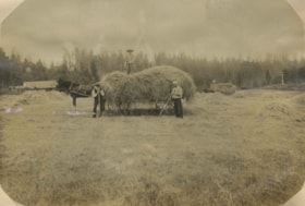
Haying at Broadview
https://search.heritageburnaby.ca/link/archivedescription39551
- Repository
- City of Burnaby Archives
- Date
- 1906
- Collection/Fonds
- Peers Family and Hill Family fonds
- Description Level
- Item
- Physical Description
- 1 photograph : b&w ; 11 x 16 cm on page 21.5 x 28 cm (pasted in album)
- Scope and Content
- Photograph of farmers in the field gathering hay with horse and wagons. In the middle of the photograph three men pose with a horse and hay wagon. The man on the right (with white shirt) is Bernard Hill. The bearded man may be Malcolm Nicholson (from whom Claude Hill bought the land to build his h…
- Repository
- City of Burnaby Archives
- Date
- 1906
- Collection/Fonds
- Peers Family and Hill Family fonds
- Physical Description
- 1 photograph : b&w ; 11 x 16 cm on page 21.5 x 28 cm (pasted in album)
- Description Level
- Item
- Record No.
- 477-870
- Access Restriction
- No restrictions
- Reproduction Restriction
- No known restrictions
- Accession Number
- 2007-12
- Scope and Content
- Photograph of farmers in the field gathering hay with horse and wagons. In the middle of the photograph three men pose with a horse and hay wagon. The man on the right (with white shirt) is Bernard Hill. The bearded man may be Malcolm Nicholson (from whom Claude Hill bought the land to build his home, Broadview). The other man is unidentified. This photograph was taken on the Broadview site, looking south, roughly at the corner of Sperling Avenue and Rugby Avenue, towards Buckingham Avenue.
- Names
- Hill, Bernard R.
- Media Type
- Photograph
- Notes
- Title based on contents of photograph
- Geographic Access
- Buckingham Avenue
- Sperling Avenue
- Rugby Street
- Historic Neighbourhood
- Burnaby Lake (Historic Neighbourhood)
- Planning Study Area
- Morley-Buckingham Area
Images

Hill family and Vidal family fonds
https://search.heritageburnaby.ca/link/archivedescription82116
- Repository
- City of Burnaby Archives
- Date
- [1850-1983]
- Collection/Fonds
- Hill family and Vidal family fonds
- Description Level
- Fonds
- Physical Description
- 255 photographs : b&w and sepia and 9.5 cm of textual records : ill. (some col.)
- Scope and Content
- Fonds consists of photographs and textual records from the Vidal and Hill family. Textual records include handwritten family trees, typed and handwritten biographical information of the Jones, Wright, Hyde, Vidal, and Hill families, copies of photographic prints, published works by J. H. Vidal and …
- Repository
- City of Burnaby Archives
- Date
- [1850-1983]
- Collection/Fonds
- Hill family and Vidal family fonds
- Physical Description
- 255 photographs : b&w and sepia and 9.5 cm of textual records : ill. (some col.)
- Description Level
- Fonds
- Access Restriction
- No restrictions
- Accession Number
- 2013-03
- Scope and Content
- Fonds consists of photographs and textual records from the Vidal and Hill family. Textual records include handwritten family trees, typed and handwritten biographical information of the Jones, Wright, Hyde, Vidal, and Hill families, copies of photographic prints, published works by J. H. Vidal and William Cowper, newspaper clippings, and a New Testament.
- History
- Minard Gerald “Gerry” Hill was born in Burnaby on July 31, 1893, to Marian (nee Berkeley) and Bernard Richard Hill. Marian was born in London, England. Bernard Hill, born in Bengal, India, in 1858 to Sir Richard Hill and Jane Ann (nee Rollinson) where his father worked for the East Indian Railway, was one of the early inhabitants of Burnaby. Despite their years of training as engineers, Bernard, along with his brother, Louis Claude Hill, became strawberry farmers and owned all the land between Burnaby Lake and Deer Lake where Deer Creek runs, and halfway around Deer Lake. Bernard built his family home at Douglas Road near Deer Lake in 1892. After the decline in the strawberry industry, Bernard worked as a surveyor for the municipality. Bernard also served as a Burnaby trustee and as councilor of Burnaby in 1904, 1905, 1906, and 1909. Bernard and Marian had four children: A. Claude (born in England around 1885, married Marion “Mamie”), Frank L., Winnifred “Winnie” L., and Gerry. Gerry attended Miss Harriet Woodward’s kindergarten class, and went on to Edmonds School with Miss Ellen Lister as his teacher. He later went to Central High School in New Westminster, often on horseback. Gerry served in World War I, signing his recruitment papers on November 9, 1914. When he returned home, he worked felling trees, then as an apprentice surveyor and finally as a carpenter. His father, Bernard, died in Burnaby on March 27, 1939, at the age of 80. Bernard's brother, Louis, was one of the first members elected to the Burnaby council and served in 1892, 1893, 1894, and again from 1909-1910. Louis, born in 1860, married Annie Sarah Kendrick (born in 1896) and they moved to the Burnaby Lake area in the early 1890s. Together they had one child, Katherine “Kitty” Maude, born in 1898. The first Hill family home, “Brookfield,” was sold around 1907 and the family moved to their new home, “Broadview,” which was also built in the vicinity of Deer Lake. Kitty, their only child, married William “Bob” John Peers in 1925 and they went on to have three children: Robert C.K., Barbara (later Barbara Jeffrey), and Anne (later Anne Latham). Charlotte Elizabeth Vidal was born in 1897 in the United States to Louisa Sophia (nee Jones) and Herbert P. Vidal. Louisa Vidal (1871-1943) was a descendent of Jones of Exeter of England and the House of Llanio Cardigan of Wales. Herbert Vidal (1868-1934)’s father was Alexander Vidal (1819-1906). Alexander Vidal, born in Brocknell, England, immigrated to Upper Canada in 1835 and later served as a senator of Canada from 1873 to 1906. He married Catherine Louisa Wright, the daughter of Capt. William Elliot Wright. Both of Charlotte’s parents, Louisa and Herbert, were born in Ontario. Charlotte Vidal was sister to Dorothy Kate and Alexander E. E. Vidal. Gerry Hill (aged 27) and Charlotte E. Vidal (aged 23) married on September 28, 1920, in Vancouver. Gerry built a house for him and his wife about a thousand feet from his parents’ home. He also bought property at Yellow Point on Vancouver Island around this time. By the early 1930s, Gerry had moved to Yellow Point permanently and begun building the Yellow Point Lodge. Gerry and Charlotte bore three children: David, Lesley C. (born in 1929), and Gerald. Gerry was later remarried to Elizabeth (nee Holen) and had one child: Richard Grant McEwan Hill, born in Ladysmith. Lesley married M. Clarke and had two boys: Roy and Graham. She later married B. Durban and had four boys: Patrick, Michael, Gary, and Grant. Charlotte died on February 11, 1984, at the age of 87. Gerry died on January 30, 1988, in Ladysmith at the age of 93.
- Media Type
- Photograph
- Textual Record
- Creator
- Hill Family
- Vidal family
- Notes
- Title based on contents of fonds
- Photo catalogue 550, MSS176
Hugh H. Stewart fonds
https://search.heritageburnaby.ca/link/museumdescription9771
- Repository
- Burnaby Village Museum
- Date
- [188_]-1960
- Collection/Fonds
- Hugh H. Stewart fonds
- Description Level
- Fonds
- Physical Description
- 12 cm of textual records + 2 photographs
- Scope and Content
- Fonds consists of textual records and photographs collected or created by Hugh H. Stewart in the course of his personal and professional life. Records include receipts relating to property sales and taxes, utilities, association memberships (Independent Order of Odd Fellows, Vancouver Heights Ratep…
- Repository
- Burnaby Village Museum
- Collection/Fonds
- Hugh H. Stewart fonds
- Description Level
- Fonds
- Physical Description
- 12 cm of textual records + 2 photographs
- Scope and Content
- Fonds consists of textual records and photographs collected or created by Hugh H. Stewart in the course of his personal and professional life. Records include receipts relating to property sales and taxes, utilities, association memberships (Independent Order of Odd Fellows, Vancouver Heights Ratepayers Association, Burnaby Lions Club and Ancient Mystic Order of Samaritans), insurance, loans and healthcare along with an elections candidate card and documents from his business “Stewart’s Cartage and Fuel Supply”; minutes from the Ratepayers Association and a handwritten recipe for potato salad. Records have been arranged into the following series: 1) Hugh H. Stewart photographs series 2) Hugh H. Stewart personal documents series 3) Stewart's Cartage and Fuel Supply business records series 4) Hugh H. Stewart associations and memberships series
- History
- Hugh Henry Stewart was born July 18 1887 to Duncan Hugh (1860-1935) and Henrietta Stewart (1860-1944) in South Bethlehem, Pennsylvania, U.S.A. The couple moved to Nanaimo in 1888 with their four children, the oldest of which was Hugh Henry. The family moved to Vancouver in about 1908 and lived at 995 West 7th Avenue while Duncan Stewart worked as a carpenter. Hugh Henry found work as a hardware clerk at the “Forbes and Van Horne” hardware store located at 52 West Hastings, Vancouver. He worked at the store until WWI broke out and his wages were cut. In 1910 Hugh Henry Stewart moved to Burnaby and purchased a house in District Lot 116, in the 3900 block of Albert Street between Ingleton Avenue and McDonald Avenue. This was the only house in this block at the time (3902 Albert Street) but the following year, five more houses were built. In 1911, Hugh married Patience (known as Bertha) Alberta Inglis of Vancouver and between 1911 and 1912, Hugh cleared land around the house. The couple raised three children at their home in Vancouver Heights (now named Burnaby Heights); Duncan Hugh, Daniel Melbourne and Audrey Pearl. In 1914, the Vancouver Heights Ratepayers Association was formed and Hugh Stewart joined. This association lobbied city council to establish land uses which they felt could benefit the citizens of North Burnaby. Following his work at the hardware store, Hugh went to work as a longshoreman at the Hastings Mill in Vancouver and the Barnet Mill in Burnaby. In the 1920s, Stewart started up his own business delivering fuel to households in North Burnaby. His business was named “Stewart’s Cartage and Fuel Supply” which had an office located at 3870 East Hastings Street. Stewart moved his business office to their home in the 1950s which continued to operate at this location until the early 1960s. In 1926, the Burnaby Board of Trade was formed with Hugh Stewart as one of the founding members. The organization changed its name to the North Burnaby Board of Trade in May 1927. Hugh served as president from 1940-1946 and was instrumental in bringing about the amalgamation of the North and South Burnaby Boards of Trade to form the Burnaby Chamber of Commerce. Hugh ran for municipal council in the 1940s and was also a member of other organizations including the Burnaby Lions Club, The International Order of the Odd Fellows (I.O.O.F.) and the Ancient Mystic Order of Samaritans. Patience Alberta Stewart died in 1967 and Hugh continued to live in their home on Albert Street until 1978. In 1979 he moved to an apartment on McGill Street in Burnaby. Hugh H. Stewart died in 1981.
- Responsibility
- Stewart, Hugh Henry
- Accession Code
- HV979.50
- Date
- [188_]-1960
- Media Type
- Textual Record
- Photograph
- Arrangement
- Records are arranged by subject and format.
- Notes
- Title based on contents of fonds
![Interior staircase, [190-] (date of original), copied 1977 thumbnail](/media/hpo/_Data/_BVM_Images/1977/1977_0099_0034_001.jpg?width=280)
Interior staircase
https://search.heritageburnaby.ca/link/museumdescription2599
- Repository
- Burnaby Village Museum
- Date
- [190-] (date of original), copied 1977
- Collection/Fonds
- Burnaby Village Museum Photograph collection
- Description Level
- Item
- Physical Description
- 1 photograph : b&w ; 25.2 x 20.2 cm print
- Scope and Content
- Photograph of an interior staircase up to the first landing. The hall is carpetted, and the architecture appears to be similar to the Patterson house interiors.
- Repository
- Burnaby Village Museum
- Collection/Fonds
- Burnaby Village Museum Photograph collection
- Description Level
- Item
- Physical Description
- 1 photograph : b&w ; 25.2 x 20.2 cm print
- Scope and Content
- Photograph of an interior staircase up to the first landing. The hall is carpetted, and the architecture appears to be similar to the Patterson house interiors.
- Subjects
- Buildings - Residential - Houses
- Accession Code
- HV977.99.34
- Access Restriction
- No restrictions
- Reproduction Restriction
- May be restricted by third party rights
- Date
- [190-] (date of original), copied 1977
- Media Type
- Photograph
- Scan Resolution
- 600
- Scan Date
- 2023-07-18
- Notes
- Title based on contents of photograph
- 1 b&w copy print accompanying
Images
![Interior staircase, [190-] (date of original), copied 1977 thumbnail](/media/hpo/_Data/_BVM_Images/1977/1977_0099_0034_001.jpg)
Jesse Love farmhouse series
https://search.heritageburnaby.ca/link/museumdescription9782
- Repository
- Burnaby Village Museum
- Date
- [1893-1970] (date of originals), copied 1988-1998, predominant 1988-2000
- Collection/Fonds
- Burnaby Village Museum fonds
- Description Level
- Series
- Physical Description
- approx. 84 cm of textual records + approx. 1,910 photographs + approx. 100 architectural drawings + 3 audio cassettes + 1 videocassette
- Scope and Content
- Series consists of records involved in the purchase, moving, restoration, research, conservation and exhibiting of the Love family farmhouse by Burnaby Village Museum. Records have been arranged into the following subseries: 1) Love farmhouse conservation work files subseries 2) Love farmhouse re…
- Repository
- Burnaby Village Museum
- Collection/Fonds
- Burnaby Village Museum fonds
- Series
- Jesse Love farmhouse series
- Description Level
- Series
- Physical Description
- approx. 84 cm of textual records + approx. 1,910 photographs + approx. 100 architectural drawings + 3 audio cassettes + 1 videocassette
- Scope and Content
- Series consists of records involved in the purchase, moving, restoration, research, conservation and exhibiting of the Love family farmhouse by Burnaby Village Museum. Records have been arranged into the following subseries: 1) Love farmhouse conservation work files subseries 2) Love farmhouse restoration photographs subseries 3) Love farmhouse curatorial files subseries 4) Love farmouse research files subseries 5) Love family photographs 6) Love farmhouse Oral History subseries 7) Love farmhouse architectural drawings subseries
- History
- Jesse Love was born in Swindon, England in 1847 and left England to work on a dairy farm in the Toronto area. While working on the farm in Toronto, he met Martha Leonard who he married in 1879. Martha was born on February 3, 1858 in Bedfordshire, England and had come to Canada with her parents George and Ann Leonard. While living in Toronto, Jesse and Martha had two children, George born March 22, 1880 and Annie Elizabeth on August 24, 1881. About one year after Annie was born, the Love family moved to North Dakota to grow wheat. While living there, they had two more children, Henry who was born August 24, 1883 and Edith Minnie born October 9, 1885. The family decided to move further west after hearing about the fairer weather conditions from Martha’s father, George Leonard, who had settled in Vancouver in 1885. On May 23, 1887, Jesse, Martha and their four children arrived in Vancouver after travelling across Canada from Winnipeg on the first transcontinental train. The Loves made their home in Vancouver while Jesse helped clear land on Granville Street. Their fifth child, Thomas Robert was born on September 17, 1887 and soon after, the family moved to Lulu Island in Richmond where they lived growing vegetables and selling them to Vancouver hotels. While living and farming on Lulu island, the couple had two more girls, Martha (Dot or Dorothy) born on December 17, 1889 and Sarah Marie, born February 8, 1892. On October 6, 1893 an agreement was signed by Jesse Love to purchase 14.52 acres of land from Joseph C. Armstrong. The acreage covered the north east section of District Lot 25 within the newly incorporated District of the Municipality of Burnaby. It was here where the original Love house was built (between October 1893 and April 15, 1894) by Jesse Love with the help of local builder George Salt and father in law, George Leonard. The house consisted of an entrance hall, dining room, lean to kitchen, master bedroom and three bedrooms upstairs. A road was constructed and named Cumberland in 1905 and ran from District Lot 25 through to District Lot 11. The address for the Love home was 1390 Cumberland Road and in the early 1960’s the address was renumbered 7651 Cumberland Street. On the land surrounding the house, Jesse Love planted an orchard along with strawberries and raspberries which he sold at the Fraser Valley Market, T.S. Anandale’s Grocery Store in New Westminster and to hotels around Vancouver. Jesse Love served on the Burnaby School Board and also as a District Councillor in 1901 and from 1904-1907. While living in the house, Jesse and Martha had four more children, Phoebe Leonard, born April 15, 1894, Esther, born August 28, 1896, John Leonard, born June 7, 1899 and Hannah Victoria (also known as Girlie) who was born May 12, 1902. As the family grew to eleven children, additions along with some substantial remodelling in the craftsman style took place. In about 1898, a north wing addition was added to include a parlour with two windows, the construction of two more bedrooms and the relocation of the stair case to the North West wall. In 1903 the front door moved to the north elevation, a front porch was extended along the east wall and a summer lean to kitchen was added to the west elevation. Between 1905 and 1910, a tin embossed ceiling was installed along with an addition of the main kitchen which included a pantry, bathtub and a back porch. In about 1912, five craftsman style windows replaced the original pioneer tent style, the front verandah was enlarged to wrap around the south and east elevations, a back door was installed in the kitchen to access the verandah and wood shingle siding and brackets were added to the exterior. In 1918, at the age of 31 years, Robert Love fell ill due to an influenza epidemic and died on November 23, 1918. Following their son’s death, Martha Love became weak and on August 24, 1920, she passed away. By this time, Jesse had sold off a large percentage of his land and his youngest daughter, Girlie decided to stay on to live and care for him. Since the house was too large for just the two of them, Jesse invited any other children to return and share the residence. For a while his son, George and his wife joined them until 1925, followed by his daughter Sarah Parker (nee Love), her husband William and their three children, Albert, Bill and Elsie. The house remained pretty unchanged until 1928 after Jesse Love died of pneumonia (March 10, 1928) and the house was purchased by Sarah and her husband William Parker who continued to live there with their children. The master bedroom wall on the main floor opened up to the dining room, the kitchen pantry and bathtub converted to an alcove with a marble counter and enlarged window and sink while the bathroom was moved to the upstairs and the furnace and coolers were installed in the crawl space under the kitchen. A hot water tank was installed in the house in 1966. Sarah continued to live in the house until a little while after her husband William died in 1961. She sold the house to her daughter Elsie and husband John Hughes in 1966, who lived in the house along with their son Brent, until August 23, 1971. Mahbir Molchan Papan and his wife Geraldine Papan bought the house August 23, 1971 and by 1982, the house was sold to Nirmal Singh Singha and Narinder Singha. The Papans continued to rent the house from Nirmal Singh Singha and Narinder Singha until the late 1980s. In 1988, the house was scheduled for demolition with the remaining property to be subdivided. Fortunately, a neighbour, Mr. Harvey Elder recognized the farmhouse's historical significance and contacted the Burnaby Historical Society. Following this event, the owners agreed to donate the building to the Burnaby Village Museum (under the Century Park Museum Association) who financed the move of the house from Cumberland Street to the museum site. Heritage planner and architect, Robert Lemon provided guidance for the project. Prior to the move, the two porches were removed and demolished while the kitchen and roof were both separated from the main house. The kitchen and roof of the house were transported to Burnaby Village Museum on May 20, 1988 by Nickel Bros. House Moving company, while the main frame of the house completed its transportation to the museum near the end of May 1988 (due to low overhead wires). The house was moved down Cumberland Street to 10th Avenue, up Canada Way to Sperling and set on temporary footings near Hart House. Robert Lemon oversaw structural improvements such as, upgrading floor joists and creating new foundations to replace the original timber foundation of the farmhouse. The restoration went through several phases of work between 1988 until it opened in November 1998. Restoration began on both the interior and exterior features to be interpreted from the period of 1925. On November 23, 1992, the building was designated a heritage building under Heritage Designation Bylaw 1992, Bylaw Number 9807. In 1993, the architecture firm of Brian G. Hart Associates was appointed for the design and construction supervision of the restoration project. Plans were created for a foundation on the museum site in 1989 and the farmhouse was eventually settled on a permanent foundation behind the Burnaby Village Museum administration building in 1993 along with the reattachment of the roof. The kitchen section was reattached to the main house in 1994 along with skirting around the foundation and the reshingling of the exterior. In 1996, the tin ceiling was removed to make way for the installation of the internal electrical system along with sprinklers, ceiling heating and fire break gyprock. The dining room ceiling joists were consolidated, a pantry and bathroom were added to the kitchen, the downstairs bedroom wall was opened and filled, the dining and kitchen doorways were widened. In 1997, a wheelchair ramp was installed along with a concrete sidewalk, stair rails, cement pads at the base of the stairs and a gravel sink for any excess water. Interior work included painting of the kitchen, restoration and furnishing of the kitchen pantry, insulation of the house floor to protect from rodents along with the reconstruction of the kitchen and house chimneys. The registrar worked together with the curator and conservator and was tasked with a large research project on the house including the family contacts and family history, property information, plans, photographs, artifacts, furnishings, stories etc. all organized in files for easy retrieval. A great deal of research and conservation was undertaken in order to make the interior of the house authentic to the time period as possible. One of the biggest projects was selecting and obtaining wall coverings since much of the original wallpaper was incomplete and poor condition. The conservator and registrar were lucky enough to locate a few samples of the original paper and engage the Bradbury and Bradbury Art Wallpaper Company of Benica, California to reproduce replica designs for free. The City of Burnaby now has its own series “Burnaby Village Papers” produced by this company which are titled “Burnaby Wall”; “Burnaby Border” and “Burnaby Ceiling”. All three of these wallpaper designs have been used in the Love farm house and are also commercially available through the Bradbury and Bradbury Art Wallpaper Company. In 1997, restoration of the kitchen was completed and opened to the public. After the completion of the dining room, main floor bedroom and parlour, the Love farmhouse exhibit opened on November 29, 1998 with an open invitation to the public and extended members of the Love family. Officials including the Mayor, Doug Drummond and Love family members were all present to cut the ribbon for the special event.
- Accession Code
- BV018.41; BV020.5
- Access Restriction
- Restricted access
- Date
- [1893-1970] (date of originals), copied 1988-1998, predominant 1988-2000
- Arrangement
- The majority of the records within series and subseries were arranged by a staff members of Burnaby Village Museum who worked on the historical research and restoration of the house. Other photographs documenting the move and further restoration work were added later and included in the arrangment by format and subject.
- Notes
- Title based on content of series
- Jesse Love farmhouse is described as an Artifact under BV988.33.1
- Some records within this collection have restricted access and are subject to FIPPA
- Accessions BV018.41 and BV020.5 form this fonds
![Lake, [1905] thumbnail](/media/hpo/_Data/_Archives_Images/_Unrestricted/477/477-135.jpg?width=280)
Lake
https://search.heritageburnaby.ca/link/archivedescription38816
- Repository
- City of Burnaby Archives
- Date
- [1905]
- Collection/Fonds
- Peers Family and Hill Family fonds
- Description Level
- Item
- Physical Description
- 1 photograph : b&w ; 5.5 x 5.5 cm on page 11.5 x 14 cm (pasted in album)
- Scope and Content
- Photograph of a lake (either Deer Lake or Burnaby Lake) with cleared land in the background.
- Repository
- City of Burnaby Archives
- Date
- [1905]
- Collection/Fonds
- Peers Family and Hill Family fonds
- Physical Description
- 1 photograph : b&w ; 5.5 x 5.5 cm on page 11.5 x 14 cm (pasted in album)
- Description Level
- Item
- Record No.
- 477-135
- Access Restriction
- No restrictions
- Reproduction Restriction
- No known restrictions
- Accession Number
- 2007-12
- Scope and Content
- Photograph of a lake (either Deer Lake or Burnaby Lake) with cleared land in the background.
- Media Type
- Photograph
- Notes
- Title based on contents of photograph
- Historic Neighbourhood
- Burnaby Lake (Historic Neighbourhood)
Images
![Lake, [1905] thumbnail](/media/hpo/_Data/_Archives_Images/_Unrestricted/477/477-135.jpg)
![Land clearing, [190-] (date of original), copied 1978 thumbnail](/media/hpo/_Data/_BVM_Images/1977/197800010007.jpg?width=280)
Land clearing
https://search.heritageburnaby.ca/link/museumdescription453
- Repository
- Burnaby Village Museum
- Date
- [190-] (date of original), copied 1978
- Collection/Fonds
- Burnaby Village Museum Photograph collection
- Description Level
- Item
- Physical Description
- 1 photograph : b&w ; 20.2 x 25.2 cm print
- Scope and Content
- Photograph of a cleared property with a thick wooded area just behind it. There is a house in the back to the extreme left of the photograph that has been identified as the Haszard house where the Sprott family stayed while building their farmhouse known as "Dovecote." There are unidentified men i…
- Repository
- Burnaby Village Museum
- Collection/Fonds
- Burnaby Village Museum Photograph collection
- Description Level
- Item
- Physical Description
- 1 photograph : b&w ; 20.2 x 25.2 cm print
- Scope and Content
- Photograph of a cleared property with a thick wooded area just behind it. There is a house in the back to the extreme left of the photograph that has been identified as the Haszard house where the Sprott family stayed while building their farmhouse known as "Dovecote." There are unidentified men in the cleared field.
- Subjects
- Land Clearing
- Geographic Access
- Canada Way
- Accession Code
- HV978.1.7
- Access Restriction
- No restrictions
- Reproduction Restriction
- No known restrictions
- Date
- [190-] (date of original), copied 1978
- Media Type
- Photograph
- Historic Neighbourhood
- Burnaby Lake (Historic Neighbourhood)
- Scan Resolution
- 600
- Scan Date
- 2023-08-01
- Notes
- Title based on contents of photograph
Images
![Land clearing, [190-] (date of original), copied 1978 thumbnail](/media/hpo/_Data/_BVM_Images/1977/197800010007.jpg)
![Land Clearing on the shores of Deer Lake, [1905] thumbnail](/media/hpo/_Data/_Archives_Images/_Unrestricted/477/477-134.jpg?width=280)
Land Clearing on the shores of Deer Lake
https://search.heritageburnaby.ca/link/archivedescription38815
- Repository
- City of Burnaby Archives
- Date
- [1905]
- Collection/Fonds
- Peers Family and Hill Family fonds
- Description Level
- Item
- Physical Description
- 1 photograph : sepia ; 5.5 x 5.5 cm on page 11.5 x 14 cm (pasted in album)
- Scope and Content
- Photograph taken looking north across Deer Lake. Smoke from a land clearing operation is visible in the background.
- Repository
- City of Burnaby Archives
- Date
- [1905]
- Collection/Fonds
- Peers Family and Hill Family fonds
- Physical Description
- 1 photograph : sepia ; 5.5 x 5.5 cm on page 11.5 x 14 cm (pasted in album)
- Description Level
- Item
- Record No.
- 477-134
- Access Restriction
- No restrictions
- Reproduction Restriction
- No known restrictions
- Accession Number
- 2007-12
- Scope and Content
- Photograph taken looking north across Deer Lake. Smoke from a land clearing operation is visible in the background.
- Media Type
- Photograph
- Notes
- Title based on contents of photograph
- Geographic Access
- Deer Lake
- Historic Neighbourhood
- Burnaby Lake (Historic Neighbourhood)
Images
![Land Clearing on the shores of Deer Lake, [1905] thumbnail](/media/hpo/_Data/_Archives_Images/_Unrestricted/477/477-134.jpg)

Linden Avenue
https://search.heritageburnaby.ca/link/archivedescription35000
- Repository
- City of Burnaby Archives
- Date
- 1908 (date of original), copied 1986
- Collection/Fonds
- Burnaby Historical Society fonds
- Description Level
- Item
- Physical Description
- 1 photograph : b&w ; 8.8 x 12.5 cm print
- Scope and Content
- Photograph of trees and stumps on Linden Avenue, Edmonds District. The caption at the bottom right of the photograph reads, "Linden Ave. / Edmonds 1908."
- Repository
- City of Burnaby Archives
- Date
- 1908 (date of original), copied 1986
- Collection/Fonds
- Burnaby Historical Society fonds
- Subseries
- Patterson family subseries
- Physical Description
- 1 photograph : b&w ; 8.8 x 12.5 cm print
- Description Level
- Item
- Record No.
- 171-021
- Access Restriction
- No restrictions
- Reproduction Restriction
- No known restrictions
- Accession Number
- BHS1986-20
- Scope and Content
- Photograph of trees and stumps on Linden Avenue, Edmonds District. The caption at the bottom right of the photograph reads, "Linden Ave. / Edmonds 1908."
- Media Type
- Photograph
- Geographic Access
- Linden Avenue
- Historic Neighbourhood
- Edmonds (Historic Neighbourhood)
- Planning Study Area
- Richmond Park Area
Images
