Narrow Results By
Creator
- Akrigg, G. P. V., 1913- 1
- Akrigg, Helen B., 1921- 1
- Anger, Harry D. (Harry Dell), 1888-1953 1
- Anger, William Henry 1
- Birrell, A. J. 1
- Bureau of Post War Rehabilitation and Reconstruction Regional Planning Division 1
- Burnaby (B.C.). Planning Department 1
- Burnaby Community Heritage Commission 1
- Burnaby, Robert, 1828-1878 1
- Burnaby Village Museum 2
- Burnett and McGugan B.C. Land Surveyors, New Westminster 5
- Burnett, David H. 1

Edmonds Street School site
https://search.heritageburnaby.ca/link/museumdescription11125
- Repository
- Burnaby Village Museum
- Date
- March 8, 1915
- Collection/Fonds
- Ronald G. Scobbie collection
- Description Level
- Item
- Physical Description
- 1 survey plan : blueprint on paper ; 56 x 54 cm
- Scope and Content
- Survey plan of "Edmonds Street School Site" "Burnaby Municipality" "Being Lots 28 and 29 of the Subdivision of Lot 30, Group 1, New Westminster District";
- Repository
- Burnaby Village Museum
- Collection/Fonds
- Ronald G. Scobbie collection
- Description Level
- Item
- Physical Description
- 1 survey plan : blueprint on paper ; 56 x 54 cm
- Material Details
- Scale: 4 feet = 1 inch
- Scope and Content
- Survey plan of "Edmonds Street School Site" "Burnaby Municipality" "Being Lots 28 and 29 of the Subdivision of Lot 30, Group 1, New Westminster District";
- Subjects
- Buildings - Schools
- Names
- Edmonds Community School
- Responsibility
- Burnett and McGugan B.C. Land Surveyors, New Westminster
- Geographic Access
- Edmonds Street
- Street Address
- 7641 Edmonds Street
- Accession Code
- BV003.83.5
- Access Restriction
- No restrictions
- Reproduction Restriction
- No known restrictions
- Date
- March 8, 1915
- Media Type
- Cartographic Material
- Historic Neighbourhood
- Edmonds (Historic Neighbourhood)
- Planning Study Area
- Edmonds Area
- Scan Resolution
- 440
- Scan Date
- 22-Dec-2020
- Scale
- 100
- Notes
- Title based on contents of plan
- Oath in bottom left corner reads: "I, D.J. McGugan...and did personally superintend the survey..." "...completed on the 8th day of March 1915"; signed "D.J. McGugan", notarized by "S.F. Mark" "sworn...12th Day of April 1915"
- handwritten on back, "1756"
Zoomable Images


Howard Avenue School site
https://search.heritageburnaby.ca/link/museumdescription11124
- Repository
- Burnaby Village Museum
- Date
- March 24, 1915
- Collection/Fonds
- Ronald G. Scobbie collection
- Description Level
- Item
- Physical Description
- 1 survey plan : blueprint on paper ; 56 x 54 cm
- Scope and Content
- Survey plan of "Howard Avenue School Site" "Burnaby Municipality", "Being Lots 1-5 and 14-18 Inc. Block 5 of the Subd. of Easterly 3/4 of Lot 127. Group 1, New Westminster District";
- Repository
- Burnaby Village Museum
- Collection/Fonds
- Ronald G. Scobbie collection
- Description Level
- Item
- Physical Description
- 1 survey plan : blueprint on paper ; 56 x 54 cm
- Material Details
- Scale: 40 feet = 1 inch
- Scope and Content
- Survey plan of "Howard Avenue School Site" "Burnaby Municipality", "Being Lots 1-5 and 14-18 Inc. Block 5 of the Subd. of Easterly 3/4 of Lot 127. Group 1, New Westminster District";
- Creator
- McGugan, Donald Johnston
- Subjects
- Buildings - Schools
- Names
- Howard Avenue School
- Responsibility
- Burnett and McGugan B.C. Land Surveyors, New Westminster
- Geographic Access
- Howard Avenue
- Georgia Street
- Accession Code
- BV003.83.4
- Access Restriction
- No restrictions
- Reproduction Restriction
- No known restrictions
- Date
- March 24, 1915
- Media Type
- Cartographic Material
- Historic Neighbourhood
- Capitol Hill (Historic Neighbourhood)
- Planning Study Area
- Capitol Hill Area
- Scan Resolution
- 440
- Scan Date
- 22-Dec-2020
- Scale
- 100
- Notes
- Title based on contents of plan
- Oath in bottom left corner reads: "I, D.J. McGugan...and did personally superintend the survey..." "...completed on the 24th day of March 1915"; signed "D.J. McGugan", notarized on April 12th, 1915 by "R. Chapman"
- handwritten on back, "1754"
Zoomable Images


Kingsway West School site
https://search.heritageburnaby.ca/link/museumdescription11122
- Repository
- Burnaby Village Museum
- Date
- March 16, 1915
- Collection/Fonds
- Ronald G. Scobbie collection
- Description Level
- Item
- Physical Description
- 1 survey plan : blueprint on paper with pencil notations ; 56 x 54 cm
- Scope and Content
- Survey plan of "Kingsway West School Site" "Burnaby Municipality" "being Lot 1, D.L.32, Lot 1 of Lot 21, Portion of Lot 21 and Portion of Lot 20, of subdivision of D.L.152, 153 & Portion of Lot 151, Group 1, New Westminster District". Notations in pencil extend along the south boundary line of Dist…
- Repository
- Burnaby Village Museum
- Collection/Fonds
- Ronald G. Scobbie collection
- Description Level
- Item
- Physical Description
- 1 survey plan : blueprint on paper with pencil notations ; 56 x 54 cm
- Material Details
- Scale: 40 feet = 1 inch
- Scope and Content
- Survey plan of "Kingsway West School Site" "Burnaby Municipality" "being Lot 1, D.L.32, Lot 1 of Lot 21, Portion of Lot 21 and Portion of Lot 20, of subdivision of D.L.152, 153 & Portion of Lot 151, Group 1, New Westminster District". Notations in pencil extend along the south boundary line of District Lot 32.
- Creator
- McGugan, Donald Johnston
- Subjects
- Buildings - Schools
- Names
- Kingsway West School
- Responsibility
- Burnett and McGugan B.C. Land Surveyors, New Westminster
- Geographic Access
- Kingsway
- Sussex Avenue
- Accession Code
- BV003.83.2
- Access Restriction
- No restrictions
- Reproduction Restriction
- No known restrictions
- Date
- March 16, 1915
- Media Type
- Cartographic Material
- Historic Neighbourhood
- Central Park (Historic Neighbourhood)
- Planning Study Area
- Maywood Area
- Scan Resolution
- 440
- Scan Date
- 22-Dec-2020
- Scale
- 100
- Notes
- Transcribed title
- Oath in bottom left corner reads: "I, D.J. McGugan...did personally superintend the survey ..." "...completed on the 16th day of March 1915", signed "D.J. McGugan" and is notarized on March 19th, 1915 by "S.F. Frank" with a seal
- handwritten on back, "1753";
- See also BV003.83.9 - duplicate blueprint plan without annotations
- See also BV003.83.3 for original plan on waxed linen
Zoomable Images

Map of Burnaby Municipality
https://search.heritageburnaby.ca/link/museumdescription8693
- Repository
- Burnaby Village Museum
- Date
- [between 1914 and 1921]
- Collection/Fonds
- Burnaby Village Museum Map collection
- Description Level
- Item
- Physical Description
- 1 map : lithographic print, ms. annotations and hand col. on linen ; 83.5 x 57.5 cm
- Scope and Content
- Map of "BURNABY / MUNICIPALITY". "COMPILED & PUBLISHED / BY / DOMINION BLUEPRINT & MAP CO. / 576 SEYMOUR STREET / PHONE SEY. 4670 / VANCOUVER, B.C." The map also includes a handwritten title in ink above which reads: "Townplanning Maps in T.135." District lots, subdivisions, wards, blocks, schools…
- Repository
- Burnaby Village Museum
- Collection/Fonds
- Burnaby Village Museum Map collection
- Description Level
- Item
- Physical Description
- 1 map : lithographic print, ms. annotations and hand col. on linen ; 83.5 x 57.5 cm
- Material Details
- Scale [1:1666]
- Scope and Content
- Map of "BURNABY / MUNICIPALITY". "COMPILED & PUBLISHED / BY / DOMINION BLUEPRINT & MAP CO. / 576 SEYMOUR STREET / PHONE SEY. 4670 / VANCOUVER, B.C." The map also includes a handwritten title in ink above which reads: "Townplanning Maps in T.135." District lots, subdivisions, wards, blocks, schools, names, roads, railways are identified in black ink along with water ways and municipal borders. Additions have been added on top of original map print which include: red dashed lines in ink; green, blue, red lines in pencil crayon; purple, brown and red watercolour on some lots along with a bridge across the Fraser R. in red ink; pencilled Standard, Shell and Union Oil properties; pencilled numbers, arrows, natural features, notes; one line is "Gas 1930", "April 1924" next to a lot notation.
- Publisher
- Compiled and Published by Dominion Blueprint & Map Co.
- Responsibility
- Hill and Barnett Land Surveyors
- Accession Code
- BV994.34.1
- Access Restriction
- No restrictions
- Reproduction Restriction
- No known restrictions
- Date
- [between 1914 and 1921]
- Media Type
- Cartographic Material
- Notes
- Transcribed title
- Scale is measured in inches to feet

Riverway School site
https://search.heritageburnaby.ca/link/museumdescription11134
- Repository
- Burnaby Village Museum
- Date
- April 16, 1915
- Collection/Fonds
- Ronald G. Scobbie collection
- Description Level
- Item
- Physical Description
- 1 survey plan : blueprint on paper ; 56 x 54 cm
- Scope and Content
- Survey plan of "Riverway School Site / Burnaby Municipality" "Being a 1 acre portion of Lot 159 Group 1, and Lots 30 & 31 of subd. of Bks. 1, 1a, 2, 3, 4 & 5 of Lot 159, Group 1, New Westminster District".
- Repository
- Burnaby Village Museum
- Collection/Fonds
- Ronald G. Scobbie collection
- Description Level
- Item
- Physical Description
- 1 survey plan : blueprint on paper ; 56 x 54 cm
- Material Details
- Scale 40 feet = 1 inch
- Scope and Content
- Survey plan of "Riverway School Site / Burnaby Municipality" "Being a 1 acre portion of Lot 159 Group 1, and Lots 30 & 31 of subd. of Bks. 1, 1a, 2, 3, 4 & 5 of Lot 159, Group 1, New Westminster District".
- Creator
- Geoffrey K. Burnett
- Subjects
- Buildings - Schools
- Names
- Riverway East School
- Responsibility
- Burnett and McGugan B.C. Land Surveyors, New Westminster
- Geographic Access
- Gilley Avenue
- Marine Drive
- Street Address
- 5787 Marine Drive
- Accession Code
- BV003.83.13
- Access Restriction
- No restrictions
- Reproduction Restriction
- No known restrictions
- Date
- April 16, 1915
- Media Type
- Cartographic Material
- Historic Neighbourhood
- Alta Vista (Historic Neighbourhood)
- Planning Study Area
- Clinton-Glenwood Area
- Scan Resolution
- 440
- Scan Date
- 22-Dec-2020
- Scale
- 100
- Notes
- Title based on contents of plan
- Note in black ink on verso of plan reads: "1744" / "Riverway School"
- Oath on plan reads: "I, Geoffrey K. Burnett...and did personally superintend the survey..." "...completed on the 16th day of April 1915"; signed by Geoffrey K. Burnett and notarized by "K.A. Eastman", sworn "...19th day of April 1915"
Zoomable Images


Second Street School site
https://search.heritageburnaby.ca/link/museumdescription11920
- Repository
- Burnaby Village Museum
- Date
- May 29, 1915
- Collection/Fonds
- Ronald G. Scobbie collection
- Description Level
- Item
- Physical Description
- 1 survey plan : blueprint on paper ; 56 x 54 cm
- Scope and Content
- Survey plan of "Second Street School Site" "Burnaby Municipality" "Being Lots 1 & 2 , Block 20 of the Subd of / Lot 27. Group 1 / New Westminster District".
- Repository
- Burnaby Village Museum
- Collection/Fonds
- Ronald G. Scobbie collection
- Description Level
- Item
- Physical Description
- 1 survey plan : blueprint on paper ; 56 x 54 cm
- Material Details
- Scale: 40 feet = 1 inch
- Scope and Content
- Survey plan of "Second Street School Site" "Burnaby Municipality" "Being Lots 1 & 2 , Block 20 of the Subd of / Lot 27. Group 1 / New Westminster District".
- Creator
- McGugan, Donald Johnston
- Subjects
- Buildings - Schools
- Names
- Edmonds Community School
- Responsibility
- Burnett and McGugan B.C. Land Surveyors, New Westminster
- Geographic Access
- Edmonds Street
- Street Address
- 7641 Edmonds Street
- Accession Code
- BV003.83.6
- Access Restriction
- No restrictions
- Reproduction Restriction
- No known restrictions
- Date
- May 29, 1915
- Media Type
- Cartographic Material
- Historic Neighbourhood
- Edmonds (Historic Neighbourhood)
- Planning Study Area
- Edmonds Area
- Scan Resolution
- 440
- Scan Date
- 22-Dec-2020
- Scale
- 100
- Notes
- Title based on contents of plan
- Oath in bottom left corner reads: "I, D.J. McGugan...and did personally superintend the survey..." "...completed on the 8th day of March 1915"; signed "D.J. McGugan / BCLS / sworn...29 day / of May 1915"
- handwritten on back, "1733"
Zoomable Images

The Acadian exiles : a chronicle of the land of Evangeline, v.9
https://search.heritageburnaby.ca/link/museumlibrary5140
- Repository
- Burnaby Village Museum
- Collection
- Special Collection
- Material Type
- Book
- Accession Code
- BV004.106.32
- Call Number
- 971 CHR v.9
- Place of Publication
- Toronto
- Publisher
- Glasgow, Brook & Company
- Publication Date
- 1916
- Series
- Chronicles of Canada, 9
- Printer
- T. and A. Constable
- Physical Description
- xi, 178 p. : col. ill., col. maps, col. port. ; 19 cm.
- Library Subject (LOC)
- Acadia
- Canada--History
- Nova Scotia--History
- Notes
- "Edited by George M. Wrong and H.H. Langton"
- "In thirty-two volumes"
- "Part III The English Invasion"
- Includes bibliographic references and index.
- Author's given names and dates: Doughty, Arthur G. (Arthur George), Sir, 1860-1936
- Editor's given names and dates: Wrong, George McKinnon, 1860-1948
- Editor's given names and dates: Langton, H.H. (Hugh Hornby), 1862-1953
Agreement for sale of land between Joseph C. Armstrong and Jesse Love re District Lot 25
https://search.heritageburnaby.ca/link/museumdescription18788
- Repository
- Burnaby Village Museum
- Date
- 6 Oct. 1893
- Collection/Fonds
- Love family fonds
- Description Level
- Item
- Physical Description
- 1 p. of textual records + 1 plan : red and black ink on linen ; 16 x 8.5 cm
- Scope and Content
- Item consists of an Agreement for Sale of Land dated October 6, 1893 between Joseph C. Armstrong and Jesse Love for District Lot 25, Group one, New Westminster District and a small hand drawn plan showing District Lot 25, Cumberland Road and location of building. Land Agreement was registered Febru…
- Repository
- Burnaby Village Museum
- Collection/Fonds
- Love family fonds
- Description Level
- Item
- Physical Description
- 1 p. of textual records + 1 plan : red and black ink on linen ; 16 x 8.5 cm
- Scope and Content
- Item consists of an Agreement for Sale of Land dated October 6, 1893 between Joseph C. Armstrong and Jesse Love for District Lot 25, Group one, New Westminster District and a small hand drawn plan showing District Lot 25, Cumberland Road and location of building. Land Agreement was registered February 13, 1894.
- Accession Code
- BV992.26.8
- Access Restriction
- No restrictions
- Reproduction Restriction
- No known restrictions
- Date
- 6 Oct. 1893
- Media Type
- Textual Record
- Cartographic Material
- Notes
- Title based on contents of item
- Document dated Oct 6 1893; "ARTICLES OF AGREEMENT" between Joseph C. Armstrong and Jesse Love; one page, folded on buff, legal-sized paper with pink borders; black print; handwritten in faded brown ink; for a parcel of land in the New Westminster District, all that portion of Lot 25, Group I, from a point on the Easterly side 20 chains from the South Easterly corner, then from the South Easterly corner, then northerly and parallel with the Cumberland Road for 10 chains and 52 links, then southerly 10 chains, then Easterly 14 chains and 52 links, total 14 acres and 52/100; for $1161 in 17 instalments at 6% interest; signed by Jesse Love and J.C. Armstrong, witnessed by H.A. Eastman; two seals are missing, pink stains on paper; addition May 1900 signed by Jesse Love and H.A. Eastman; folds twice; when folded, panel showing is "AGREEMENT for Sale of Land." "on Cumberland road in Lot 25 Group I"; handwritten "H.A. Eastman" over printed "E.H. PORT & CO.", "REAL ESTATE BROKERS" "NEW WESTMINSTER BRITISH COLUMBIA"; back panel has blue stamping and pink additions, giving No. 546C, registered February 13, 1894, Charge Book Vol. 13, Folio 51, signed C.S. Corrigan? District Registrar; with hand-drawn plan on stained linen, pink ink with black additions, shows Cumberland Road and city limits.

British Columbia chronicle, 1788-1846 : adventures by sea and land
https://search.heritageburnaby.ca/link/museumlibrary1106
- Repository
- Burnaby Village Museum
- Collection
- Reference Collection
- Material Type
- Book
- ISBN
- 0919624022
- 9780919624023
- Call Number
- 971.1 AKR
- Place of Publication
- [Vancouver]
- Publisher
- Discovery Press
- Publication Date
- 1975
- Physical Description
- xv, 429 p., [12] leaves of plates : ill. ; 23 cm.
- Library Subject (LOC)
- British Columbia--History
- Notes
- Includes bibliographical references (p. 407-416) and index.
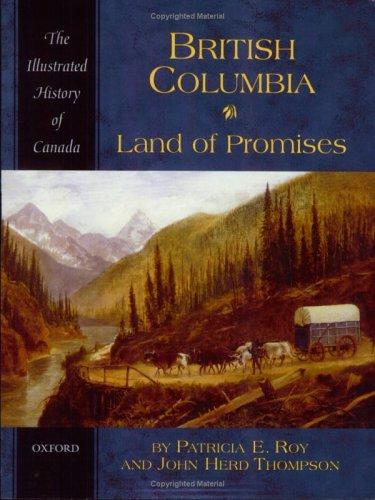
British Columbia : land of promises
https://search.heritageburnaby.ca/link/museumlibrary1422
- Repository
- Burnaby Village Museum
- Collection
- Reference Collection
- Material Type
- Book
- ISBN
- 0195410483
- Call Number
- 971.1 ROY
- Place of Publication
- Toronto
- Publisher
- Oxford University Press
- Publication Date
- 2005
- Physical Description
- 216 p., [10] p. of plates : ill. (some col.), maps (some col.), ports. (some col.) ; 24 cm.
- Library Subject (LOC)
- British Columbia--History
- British Columbia--History--Pictorial works
- Notes
- Includes bibliographical references (p. [206]-211) and index.
Cancellation of street ends - DL 189 (East Vancouver Land Co.)
https://search.heritageburnaby.ca/link/archivedescription965
- Repository
- City of Burnaby Archives
- Date
- 1914
- Collection/Fonds
- City Council and Office of the City Clerk fonds
- Description Level
- File
- Physical Description
- Textual record and cartographic material
- Scope and Content
- File contains correspondence related to the proposed cancellation of street ends/road allowances in DL 189 made by the East Vancouver Land Company. File also includes 2 white linen plans: lot 218, NWD (1909) on Burrard Inlet and Lots around 1st Street and Water Street.
- Repository
- City of Burnaby Archives
- Date
- 1914
- Collection/Fonds
- City Council and Office of the City Clerk fonds
- Physical Description
- Textual record and cartographic material
- Description Level
- File
- Record No.
- 2738
- Accession Number
- 2001-02
- Scope and Content
- File contains correspondence related to the proposed cancellation of street ends/road allowances in DL 189 made by the East Vancouver Land Company. File also includes 2 white linen plans: lot 218, NWD (1909) on Burrard Inlet and Lots around 1st Street and Water Street.
- Media Type
- Textual Record
- Cartographic Material
- Notes
- Plans/maps are located in file and have not been moved to map case.
Digest of the mercantile laws of Canada and Newfoundland : the technical points and main features of both the common and statute laws, together with the various legal and business documents in general use, forming a work of ready-reference for magistrates, conveyancers, professional and business men, land owners, contractors, etc. : lawyers will also find it convenient as a condensed and well- classified collection of most vital legal points for the various provinces
https://search.heritageburnaby.ca/link/museumlibrary3504
- Repository
- Burnaby Village Museum
- Author
- Anger, William Henry
- Edition
- 10th ed.
- Dominion ed.
- Publication Date
- c1917
- Call Number
- 346.7107 ANG 1917
- Repository
- Burnaby Village Museum
- Collection
- Special Collection
- Material Type
- Book
- Accession Code
- BV995.7.1
- Call Number
- 346.7107 ANG 1917
- Edition
- 10th ed.
- Dominion ed.
- Author
- Anger, William Henry
- Contributor
- Anger, Harry D. (Harry Dell), 1888-1953
- Place of Publication
- Toronto, Ont.
- Publisher
- W. H. Anger
- Publication Date
- c1917
- Printer
- Law Book Publisher
- Physical Description
- 280 p. : facsims., forms ; 26 cm.
- Inscription
- "No. 370 private library of _______" -- stickered on endpaper (front).
- Library Subject (LOC)
- Commercial law--Canada
- Commercial law--Newfoundland and Labrador
- Notes
- "Seventy-Fourth Thousand ; Revised to date." -- title page.
- Includes index.
- Anger, W. H. (William Henry), 1846 -
Heroes of land and sea : selected from the works of Sir Henry Newbolt
https://search.heritageburnaby.ca/link/museumlibrary272
- Repository
- Burnaby Village Museum
- Collection
- Special Collection
- Material Type
- Book
- Accession Code
- HV971.169.24
- Call Number
- 920.02 NEW
- Place of Publication
- Toronto
- Publisher
- Longmans, Green and Co.
- Publication Date
- 1926
- Printer
- William Clowes and Sons, Limited
- Physical Description
- ix, 177 p. ; 19 cm.
- Inscription
- "D" [handwritten in black ink on front cover] "H" [handwritten in black ink on back cover] "H Ray" [handwritten in black ink on front endpaper] "Herbert Davidson" [handwritten in black ink on front endpaper] "Heritage Village S3 x" [handwritten in black ink on white label pasted onto contents page] Various drawings with captions and poems handwritten in pencil or black ink on every blank page, including the title page.
- Library Subject (LOC)
- Heroes--Great Britain
- Adventure stories
- Biography

In a strange land : a pictorial record of the Chinese in Canada 1788-1923
https://search.heritageburnaby.ca/link/museumlibrary1169
- Repository
- Burnaby Village Museum
- Author
- Wright, Richard, 1940-
- Publication Date
- c1988
- Call Number
- 971.2 WRI
- Repository
- Burnaby Village Museum
- Collection
- Reference Collection
- Material Type
- Book
- ISBN
- 0888332696
- 9780888332691
- Call Number
- 971.2 WRI
- Author
- Wright, Richard, 1940-
- Place of Publication
- Saskatoon, Sask.
- Publisher
- Western Producer Prairie Books
- Publication Date
- c1988
- Physical Description
- vii, 119 p. : ill. ; 24 cm.
- Library Subject (LOC)
- Chinese--Canada, Western--History--Pictorial works
- Canada, Western--History--Pictorial works
- Chinese Canadians--History--Pictorial works
- Notes
- Includes bibliographical references (p. 116).
Into the silent land : survey photography in the Canadian West, 1858-1900 : a Public Archives of Canada travelling exhibition
https://search.heritageburnaby.ca/link/museumlibrary1248
- Repository
- Burnaby Village Museum
- Collection
- Reference Collection
- Material Type
- Book
- Call Number
- 970 BIR
- Place of Publication
- Ottawa
- Publisher
- Public Archives of Canada
- Publication Date
- 1975
- Physical Description
- [50] p. : ill. ; 21 x 23 cm.
- Inscription
- "CANADA PUBLIC ARCHIVES", handwritten in pencil on cover page.
- "BURNABY ART GALLERY / 6344 DEER LAKE AVENUE / BURNABY, B.C. V5G 2J3 / PHONE 291-9441", stamped in ink on cover page.
- Library Subject (LOC)
- Photography--Northwest Territories--Exhibitions
Land of promise : Robert Burnaby's letters from colonial British Columbia, 1858-1863
https://search.heritageburnaby.ca/link/museumlibrary5465
- Repository
- Burnaby Village Museum
- Publication Date
- c2002
- Call Number
- 971.1 BUR COPY 3
Burnaby, Numbers: 24, 29, 39 and 40 reproduced with permission of
Pat Burnaby and Meg Kennedy Shaw.
ALL RIGHTS RESERVED
National Library of Canada Cataloguing in Publication Data
Burnaby, Robert, 1828-1878
Land of Promise
Includes biographical references and index.
ISBN 0-9692828-5-0
1.Burnaby, Robert
- Repository
- Burnaby Village Museum
- Collection
- Reference Collection
- Digital Reference Collection
- Material Type
- Book
- ISBN
- 0969282850
- 9780969282853
- Call Number
- 971.1 BUR COPY 3
- Place of Publication
- Burnaby, B.C.
- Publisher
- City of Burnaby
- Publication Date
- c2002
- Physical Description
- 199 p. : ill. ; 23 cm.
- Library Subject (LOC)
- Burnaby, Robert--Correspondence
- Merchants--British Columbia--Correspondence
- British Columbia--History--1849-1871
- Burnaby (B.C.)
- Biography
- Notes
- Includes bibliographical references (p. 190) and index.
- 3 copies held: copy 3.
Digital Books
Love and Leonard land records series
https://search.heritageburnaby.ca/link/museumdescription18838
- Repository
- Burnaby Village Museum
- Date
- 1893-1962
- Collection/Fonds
- Love family fonds
- Description Level
- Series
- Physical Description
- 5 plans + 8 cm of textual records
- Scope and Content
- Series consists of land deeds, land sale agreements, documents regarding payment and survey and subdivision plans. Records refer to the Love family property in District Lot 25, the Leonard family property in District Lot 352 and other lots in Burnaby.
- Repository
- Burnaby Village Museum
- Collection/Fonds
- Love family fonds
- Description Level
- Series
- Physical Description
- 5 plans + 8 cm of textual records
- Scope and Content
- Series consists of land deeds, land sale agreements, documents regarding payment and survey and subdivision plans. Records refer to the Love family property in District Lot 25, the Leonard family property in District Lot 352 and other lots in Burnaby.
- Accession Code
- BV992.26
- BV012.31
- Date
- 1893-1962
- Media Type
- Textual Record
- Cartographic Material
- Notes
- Title based on contents of series
Surveyor's tables : being the tables from the Manual of land surveying
https://search.heritageburnaby.ca/link/museumlibrary1758
- Repository
- Burnaby Village Museum
- Author
- Hodgman, F., 1839-1907
- Publication Date
- 1897
- Call Number
- 526.9 HOD
- Repository
- Burnaby Village Museum
- Collection
- Special Collection
- Material Type
- Book
- Accession Code
- BV984.58.33
- Call Number
- 526.9 HOD
- Author
- Hodgman, F., 1839-1907
- Place of Publication
- Michigan
- Publisher
- F. Hodgman
- Publication Date
- 1897
- Physical Description
- i-vi; 127 p. : tables ; 15 cm.
- Inscription
- "W.J.H. Holmes" "1.50" inside back pages have handwritten notes
- Library Subject (LOC)
- Surveying
- Notes
- Author's given name and dates: Hodgman, F. (Francis), 1839-1907.
Surveyor's tables: being the tables from the Manual of land surveying
https://search.heritageburnaby.ca/link/museumlibrary1762
- Repository
- Burnaby Village Museum
- Author
- Hodgman, F., 1839-1907
- Publication Date
- 1910
- Call Number
- 526.9 HOD
- Repository
- Burnaby Village Museum
- Collection
- Special Collection
- Material Type
- Book
- Accession Code
- BV984.58.38
- Call Number
- 526.9 HOD
- Author
- Hodgman, F., 1839-1907
- Place of Publication
- Michigan
- Publisher
- The F. Hodgman Co.
- Publication Date
- 1910
- Physical Description
- 112 p. : tables ; 14 cm.
- Library Subject (LOC)
- Surveying
- Notes
- "Mean refraction sheet attached."
- Author's given name and dates: Hodgman, F. (Francis), 1839-1907.
Thrilling stories of the Russian-Japanese war : a vivid panorama of land and naval battles : a realistic description of twentieth century warfare ; the awful struggle for Japanese freedom, the peace and safety of the orient, and the protection of helpless China from the greed of foreign foes. Also a complete history of Japan, Russia, China, Korea and Manchuria, including progress, national traits and customs, religion, philosophy, personal adventure, etc.
https://search.heritageburnaby.ca/link/museumlibrary512
- Repository
- Burnaby Village Museum
- Collection
- Special Collection
- Material Type
- Book
- Accession Code
- BV986.53.19
- Call Number
- 952.031 MIL
- Place of Publication
- [S.l]
- Publisher
- [s.n.]
- Publication Date
- c1904
- Physical Description
- 463 p., [50] p. of plates : ill., maps, ports. ; 25 cm.
- Inscription
- "Presented to Violet Winters From Percy E. Haseltine" [handwritten in black ink on front endpaper]
- Library Subject (LOC)
- Russo-Japanese War, 1904-1905
- Russia--History--1904-1917
- Japan--History--20th century
- Notes
- "with an introduction by General Nelson A. Miles"--T.p.
- "The Japanese Point of View by Kogoro Takahira"--p.7
- "Graphically illustrated with nearly 100 superb engravings ; consisting of land and naval battles, views of war ships, portraits of Russian and Japanese commanders, pictures of famous cities, forts, temples and snap-shots of every-day life"--T.p.
- Author's given name and dates: Miller, J. Martin (James Martin), 1859-1939