Narrow Results By
Decade
- 2020s 69
- 2010s 159
- 2000s 264
- 1990s 342
- 1980s 373
- 1970s 443
- 1960s 321
- 1950s 572
- 1940s 471
- 1930s 324
- 1920s 567
- 1910s 278
- 1900s 178
- 1890s 83
- 1880s 15
- 1870s 13
- 1860s 22
- 1850s 11
- 1840s 4
- 1830s 2
- 1820s 2
- 1810s 2
- 1800s 2
- 1790s 2
- 1780s 1
- 1770s 1
- 1760s 1
- 1750s 1
- 1740s 1
- 1730s 1
- 1720s 1
- 1710s 1
- 1700s 1
- 1690s 1
- 1680s 1
- 1670s 1
- 1660s 1
- 1650s 1
- 1640s 1
- 1630s 1
- 1620s 1
- 1610s 1
- 1600s 1
Subject
- Advertising Medium 2
- Advertising Medium - Flyer 1
- Advertising Medium - Signs and Signboards 4
- Aerial Photographs 4
- Agricultural Tools and Equipment 1
- Agricultural Tools and Equipment - Plows 3
- Agriculture 11
- Agriculture - Crops 3
- Agriculture - Farms 13
- Agriculture - Fruit and Berries 3
- Animals - Bears 2
- Animals - Birds 2
Agreement for sale of land between Joseph C. Armstrong and Jesse Love re District Lot 25
https://search.heritageburnaby.ca/link/museumdescription18788
- Repository
- Burnaby Village Museum
- Date
- 6 Oct. 1893
- Collection/Fonds
- Love family fonds
- Description Level
- Item
- Physical Description
- 1 p. of textual records + 1 plan : red and black ink on linen ; 16 x 8.5 cm
- Scope and Content
- Item consists of an Agreement for Sale of Land dated October 6, 1893 between Joseph C. Armstrong and Jesse Love for District Lot 25, Group one, New Westminster District and a small hand drawn plan showing District Lot 25, Cumberland Road and location of building. Land Agreement was registered Febru…
- Repository
- Burnaby Village Museum
- Collection/Fonds
- Love family fonds
- Description Level
- Item
- Physical Description
- 1 p. of textual records + 1 plan : red and black ink on linen ; 16 x 8.5 cm
- Scope and Content
- Item consists of an Agreement for Sale of Land dated October 6, 1893 between Joseph C. Armstrong and Jesse Love for District Lot 25, Group one, New Westminster District and a small hand drawn plan showing District Lot 25, Cumberland Road and location of building. Land Agreement was registered February 13, 1894.
- Accession Code
- BV992.26.8
- Access Restriction
- No restrictions
- Reproduction Restriction
- No known restrictions
- Date
- 6 Oct. 1893
- Media Type
- Textual Record
- Cartographic Material
- Notes
- Title based on contents of item
- Document dated Oct 6 1893; "ARTICLES OF AGREEMENT" between Joseph C. Armstrong and Jesse Love; one page, folded on buff, legal-sized paper with pink borders; black print; handwritten in faded brown ink; for a parcel of land in the New Westminster District, all that portion of Lot 25, Group I, from a point on the Easterly side 20 chains from the South Easterly corner, then from the South Easterly corner, then northerly and parallel with the Cumberland Road for 10 chains and 52 links, then southerly 10 chains, then Easterly 14 chains and 52 links, total 14 acres and 52/100; for $1161 in 17 instalments at 6% interest; signed by Jesse Love and J.C. Armstrong, witnessed by H.A. Eastman; two seals are missing, pink stains on paper; addition May 1900 signed by Jesse Love and H.A. Eastman; folds twice; when folded, panel showing is "AGREEMENT for Sale of Land." "on Cumberland road in Lot 25 Group I"; handwritten "H.A. Eastman" over printed "E.H. PORT & CO.", "REAL ESTATE BROKERS" "NEW WESTMINSTER BRITISH COLUMBIA"; back panel has blue stamping and pink additions, giving No. 546C, registered February 13, 1894, Charge Book Vol. 13, Folio 51, signed C.S. Corrigan? District Registrar; with hand-drawn plan on stained linen, pink ink with black additions, shows Cumberland Road and city limits.
Love and Leonard land records series
https://search.heritageburnaby.ca/link/museumdescription18838
- Repository
- Burnaby Village Museum
- Date
- 1893-1962
- Collection/Fonds
- Love family fonds
- Description Level
- Series
- Physical Description
- 5 plans + 8 cm of textual records
- Scope and Content
- Series consists of land deeds, land sale agreements, documents regarding payment and survey and subdivision plans. Records refer to the Love family property in District Lot 25, the Leonard family property in District Lot 352 and other lots in Burnaby.
- Repository
- Burnaby Village Museum
- Collection/Fonds
- Love family fonds
- Description Level
- Series
- Physical Description
- 5 plans + 8 cm of textual records
- Scope and Content
- Series consists of land deeds, land sale agreements, documents regarding payment and survey and subdivision plans. Records refer to the Love family property in District Lot 25, the Leonard family property in District Lot 352 and other lots in Burnaby.
- Accession Code
- BV992.26
- BV012.31
- Date
- 1893-1962
- Media Type
- Textual Record
- Cartographic Material
- Notes
- Title based on contents of series

East Burnaby School (Edmonds Street School)
https://search.heritageburnaby.ca/link/landmark735
- Repository
- Burnaby Heritage Planning
- Geographic Access
- Canada Way
- Associated Dates
- 1894
- Heritage Value
- One of the first tasks of Burnaby's Municipal Government upon its incorporation was to lobby for a public school in Burnaby. By 1893, land on Douglas Road near Edmonds was donated and the new school was built in 1893. The one-room school opened on January 22, 1894 with 29 students under the charge of teacher, Ethel LePage. The School has been known as the Burnaby School (until1896), and then East Burnaby School from 1896 to 1907 and finally, Edmonds Street School.
- Historic Neighbourhood
- Edmonds (Historic Neighbourhood)
- Planning Study Area
- Edmonds Area
- Street Address
- 7376 Canada Way
- Street View URL
- Google Maps Street View
Images

Affidavit certificate re H.A. Eastman, Jessie Love and J.E. Armstrong
https://search.heritageburnaby.ca/link/museumdescription18802
- Repository
- Burnaby Village Museum
- Date
- 9 Feb. 1894
- Collection/Fonds
- Love family fonds
- Description Level
- Item
- Physical Description
- 1 p. of textual records
- Scope and Content
- Item consists of an affidavit certificate re H.A. Eastman, Jesse Love and J.C. Armstrong signed by Commissioner for taking affidavits to be used in the Supreme Court of British Columbia.
- Repository
- Burnaby Village Museum
- Collection/Fonds
- Love family fonds
- Description Level
- Item
- Physical Description
- 1 p. of textual records
- Scope and Content
- Item consists of an affidavit certificate re H.A. Eastman, Jesse Love and J.C. Armstrong signed by Commissioner for taking affidavits to be used in the Supreme Court of British Columbia.
- Accession Code
- BV992.26.22
- Access Restriction
- No restrictions
- Reproduction Restriction
- No known restrictions
- Date
- 9 Feb. 1894
- Media Type
- Textual Record
- Notes
- Title based on contents of item
- Certificate, blue paper with black print, blank areas filled in with handwriting in brown ink; "I hereby certify that" "H.A. Eastman" "personally known to me, appeared before me and acknowledged to me that" "he" "the person whose name is subscribed to the annexed Instrument as Witness, and having been duly sworn by me, did prove to me that" "Jesse Love & J.C. Armstrong" "did execute the same in his presence voluntarily." "IN TESTIMONY whereof, I have hereto set my Hand and Seal of Office, at" "New Westminster" ", British Columbia, this" "9th" "day of" "February" "in the year of Our Lord one thousand eight hundred and ninety-" "four"; signed in black ink, "J. Brisere Cheny"?; stamped purple "A Commissioner for taking affidavits to be used in the Supreme Court of British Columbia".
Description of Mr. Love's Property
https://search.heritageburnaby.ca/link/museumdescription18804
- Repository
- Burnaby Village Museum
- Date
- [1894]
- Collection/Fonds
- Love family fonds
- Description Level
- Item
- Physical Description
- 1 p. of textual records
- Scope and Content
- Item consists of a document titled "Description of Mr. Love's Property". The document describes Jesse Love's property located at the north east corner of District Lot 25 located on Cumberland Road in Burnaby.
- Repository
- Burnaby Village Museum
- Collection/Fonds
- Love family fonds
- Description Level
- Item
- Physical Description
- 1 p. of textual records
- Scope and Content
- Item consists of a document titled "Description of Mr. Love's Property". The document describes Jesse Love's property located at the north east corner of District Lot 25 located on Cumberland Road in Burnaby.
- Accession Code
- BV992.26.24
- Access Restriction
- No restrictions
- Reproduction Restriction
- No known restrictions
- Date
- [1894]
- Media Type
- Textual Record
- Notes
- Transcribed title
- Document, buff paper, legal-sized, typed in black carbon; "DESCRIPTION OF MR. LOVE'S PROPERTY" at top, underlined; "Commencing at a post at the north-east corner of lot twenty-five (25); thence southerly along the westerly line of the Cumberland Road thirty-four (34) chains and eighty-four (84) links; thence westerly and parallel with the line between/ district lots twenty-five (25) and eighty-eight (88) fourteen (14) chains and fifty (50) links thence northerly and parallel with the Cumberland Road thirty-four (34) chains and eighty-four (84) links thence eatserly along the line between said lots twenty-five and eighty eight (88) to point of commencement containing fifty and five hundred and eighteen thousandths (50.518) acres more or less" [NOTE "eatserly" is as written on document]
- watermark "WESTMINSTER BOND"; pencilled on reverse, "63 - 00", line, "31 1-0" and six short marks like checks
Settling Limits of the Road Alongside Breuchley's Land in Despute
https://search.heritageburnaby.ca/link/councilreport78751
- Repository
- City of Burnaby Archives
- Report ID
- 82745
- Meeting Date
- 18-Aug-1894
- Format
- Council - Mayor/Councillor/Staff Report
- Collection/Fonds
- City Council and Office of the City Clerk fonds
- Repository
- City of Burnaby Archives
- Report ID
- 82745
- Meeting Date
- 18-Aug-1894
- Format
- Council - Mayor/Councillor/Staff Report
- Collection/Fonds
- City Council and Office of the City Clerk fonds
Documents
Boundary Lines of Brenchley Land
https://search.heritageburnaby.ca/link/councilreport78817
- Repository
- City of Burnaby Archives
- Report ID
- 82795
- Meeting Date
- 17-Nov-1894
- Format
- Council - Mayor/Councillor/Staff Report
- Collection/Fonds
- City Council and Office of the City Clerk fonds
- Repository
- City of Burnaby Archives
- Report ID
- 82795
- Meeting Date
- 17-Nov-1894
- Format
- Council - Mayor/Councillor/Staff Report
- Collection/Fonds
- City Council and Office of the City Clerk fonds
Documents
Improvement of Land Entered on Assessment Roll
https://search.heritageburnaby.ca/link/councilreport78937
- Repository
- City of Burnaby Archives
- Report ID
- 82949
- Meeting Date
- 9-Feb-1895
- Format
- Council - Mayor/Councillor/Staff Report
- Collection/Fonds
- City Council and Office of the City Clerk fonds
- Repository
- City of Burnaby Archives
- Report ID
- 82949
- Meeting Date
- 9-Feb-1895
- Format
- Council - Mayor/Councillor/Staff Report
- Collection/Fonds
- City Council and Office of the City Clerk fonds
Documents
Pettition to Reduce Charge on Goot Lands
https://search.heritageburnaby.ca/link/councilreport78945
- Repository
- City of Burnaby Archives
- Report ID
- 82953
- Meeting Date
- 23-Feb-1895
- Format
- Council - Mayor/Councillor/Staff Report
- Collection/Fonds
- City Council and Office of the City Clerk fonds
- Repository
- City of Burnaby Archives
- Report ID
- 82953
- Meeting Date
- 23-Feb-1895
- Format
- Council - Mayor/Councillor/Staff Report
- Collection/Fonds
- City Council and Office of the City Clerk fonds
Documents
Complaint re Lot 33 Assessed as Wild Land
https://search.heritageburnaby.ca/link/councilreport79118
- Repository
- City of Burnaby Archives
- Report ID
- 83137
- Meeting Date
- 24-Aug-1895
- Format
- Council - Mayor/Councillor/Staff Report
- Collection/Fonds
- City Council and Office of the City Clerk fonds
- Repository
- City of Burnaby Archives
- Report ID
- 83137
- Meeting Date
- 24-Aug-1895
- Format
- Council - Mayor/Councillor/Staff Report
- Collection/Fonds
- City Council and Office of the City Clerk fonds
Documents
Allow Ditch Carried through J.Blackburn's Land
https://search.heritageburnaby.ca/link/councilreport79308
- Repository
- City of Burnaby Archives
- Report ID
- 83330
- Meeting Date
- 21-Mar-1896
- Format
- Council - Mayor/Councillor/Staff Report
- Collection/Fonds
- City Council and Office of the City Clerk fonds
- Repository
- City of Burnaby Archives
- Report ID
- 83330
- Meeting Date
- 21-Mar-1896
- Format
- Council - Mayor/Councillor/Staff Report
- Collection/Fonds
- City Council and Office of the City Clerk fonds
Documents
Contract to E.Easthope for Ditch Through Blackburn's Land
https://search.heritageburnaby.ca/link/councilreport79316
- Repository
- City of Burnaby Archives
- Report ID
- 83334
- Meeting Date
- 4-Apr-1896
- Format
- Council - Mayor/Councillor/Staff Report
- Collection/Fonds
- City Council and Office of the City Clerk fonds
- Repository
- City of Burnaby Archives
- Report ID
- 83334
- Meeting Date
- 4-Apr-1896
- Format
- Council - Mayor/Councillor/Staff Report
- Collection/Fonds
- City Council and Office of the City Clerk fonds
Documents
Contract to Messrs Patterson and Milbrown for Clearing Land within Road Limits of Central Park
https://search.heritageburnaby.ca/link/councilreport79354
- Repository
- City of Burnaby Archives
- Report ID
- 83362
- Meeting Date
- 20-Jun-1896
- Format
- Council - Mayor/Councillor/Staff Report
- Collection/Fonds
- City Council and Office of the City Clerk fonds
- Repository
- City of Burnaby Archives
- Report ID
- 83362
- Meeting Date
- 20-Jun-1896
- Format
- Council - Mayor/Councillor/Staff Report
- Collection/Fonds
- City Council and Office of the City Clerk fonds
Documents
Thistle Growing on Land Near Power House
https://search.heritageburnaby.ca/link/councilreport79359
- Repository
- City of Burnaby Archives
- Report ID
- 83367
- Meeting Date
- 4-Jul-1896
- Format
- Council - Mayor/Councillor/Staff Report
- Collection/Fonds
- City Council and Office of the City Clerk fonds
- Repository
- City of Burnaby Archives
- Report ID
- 83367
- Meeting Date
- 4-Jul-1896
- Format
- Council - Mayor/Councillor/Staff Report
- Collection/Fonds
- City Council and Office of the City Clerk fonds
Documents
Complaint re Damage by Water from Road Ditch Running onto his land
https://search.heritageburnaby.ca/link/councilreport79390
- Repository
- City of Burnaby Archives
- Report ID
- 83398
- Meeting Date
- 24-Oct-1896
- Format
- Council - Mayor/Councillor/Staff Report
- Collection/Fonds
- City Council and Office of the City Clerk fonds
- Repository
- City of Burnaby Archives
- Report ID
- 83398
- Meeting Date
- 24-Oct-1896
- Format
- Council - Mayor/Councillor/Staff Report
- Collection/Fonds
- City Council and Office of the City Clerk fonds
Documents
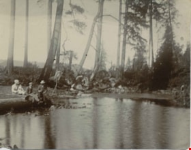
Deer Lake Near Outflow
https://search.heritageburnaby.ca/link/archivedescription39421
- Repository
- City of Burnaby Archives
- Date
- 1897
- Collection/Fonds
- Peers Family and Hill Family fonds
- Description Level
- Item
- Physical Description
- 1 photograph : b&w ; 10 x 12.6 cm
- Scope and Content
- Photograph of three unidentified people sitting on the bank of Deer Lake. Cleared land and felled trees can be seen in the background.
- Repository
- City of Burnaby Archives
- Date
- 1897
- Collection/Fonds
- Peers Family and Hill Family fonds
- Physical Description
- 1 photograph : b&w ; 10 x 12.6 cm
- Description Level
- Item
- Record No.
- 477-740
- Access Restriction
- No restrictions
- Reproduction Restriction
- No known restrictions
- Accession Number
- 2007-12
- Scope and Content
- Photograph of three unidentified people sitting on the bank of Deer Lake. Cleared land and felled trees can be seen in the background.
- Media Type
- Photograph
- Notes
- Title based on caption accompanying photograph
- Geographic Access
- Deer Lake
- Historic Neighbourhood
- Burnaby Lake (Historic Neighbourhood)
Images

Interview with Kathleen Rose July 14, 1975 - Track 1
https://search.heritageburnaby.ca/link/oralhistory146
- Repository
- City of Burnaby Archives
- Date Range
- 1897-1934
- Length
- 0:10:37
- Summary
- This portion of the interview pertains to Kathleen Rose's first memories of coming to North Burnaby as well as of her husband's employment. She discusses quilt-making among families experiencing economic hardship.
- Repository
- City of Burnaby Archives
- Summary
- This portion of the interview pertains to Kathleen Rose's first memories of coming to North Burnaby as well as of her husband's employment. She discusses quilt-making among families experiencing economic hardship.
- Date Range
- 1897-1934
- Length
- 0:10:37
- Subjects
- Buildings - Residences - Houses
- Geographic Access
- Albert Street
- Historic Neighbourhood
- Capitol Hill (Historic Neighbourhood)
- Planning Study Area
- Capitol Hill Area
- Interviewer
- Bradbury, Dr. Bettina
- Interview Date
- July 14, 1975
- Scope and Content
- Recording is of an interview with Kathleen Rose by SFU (Simon Fraser University) student Bettina Bradbury, July 14, 1975. Major theme discussed is: the Depression.
- Biographical Notes
- Kathleen Rose was born in Dublin, Ireland in 1897 and immigrated to Prince Albert, Saskatchewan in 1907 with her family. Kathleen lived on the Prairie for eighteen years before getting married in 1923 and moving to Burnaby to be with her husband. The couple moved to the 4600 block of Albert Street in North Burnaby, where Kathleen’s husband cleared all of the land by hand. The Roses had help putting in the foundation but otherwise built their house themselves. Kathleen’s husband was a longshoreman at that time. They had a son, born in 1925, who suffered from rheumatic fever during the Depression.
- Total Tracks
- 4
- Total Length
- 0:35:42
- Interviewee Name
- Rose, Kathleen
- Interviewer Bio
- Bettina Bradbury teaches history and women's studies at York University. She is the author of Wife to Widow. Lives, Laws and Politics in Nineteenth-century Montreal. (Vancouver: University of British Columbia Press, June 2011), 520p; Working Families. Age, Gender and Daily Survival in Industrializing Montreal. (Toronto: Canadian Social History Series, McClelland and Stewart, 1993); (Republished Toronto: Oxford University Press, 1996) (3rd edition, Toronto: University of Toronto Press, 2007). These interviews were undertaken after she completed her MA at Simon Fraser University in 1975 with the support of an LIP grant.
- Collection/Fonds
- Burnaby Historical Society fonds
- Subseries
- Oral history subseries
- Media Type
- Sound Recording
- Web Notes
- Interview was digitized in 2010 allowing it to be accessible on Heritage Burnaby. The digitization project was initiated by the Community Heritage Commission with support from City of Burnaby Council and the BC History Digitization Program of the Irving K. Barber Learning Centre, University of British Columbia. It was recognized by the Heritage Society of BC with an award in 2012.
Audio Tracks
Track one of interview with Kathleen Rose
Track one of interview with Kathleen Rose
https://search.heritageburnaby.ca/media/hpo/_Data/_Archives_Oral_Histories/_Unrestricted/100-13-21/100-13-21_Track_1.mp3![Douglas Road, [1897] (date of original), copied 1978 thumbnail](/media/hpo/_Data/_BVM_Images/1978/1978_0001_0001_001.jpg?width=280)
Douglas Road
https://search.heritageburnaby.ca/link/museumdescription447
- Repository
- Burnaby Village Museum
- Date
- [1897] (date of original), copied 1978
- Collection/Fonds
- Burnaby Village Museum Photograph collection
- Description Level
- Item
- Physical Description
- 1 photograph : b&w ; 20.2 x 25.2 cm print
- Scope and Content
- Photograph of Douglas Road (later renamed in part Canada Way), near Stanley Street. To the right is the Sprott family property, where a few wooden buildings are visible in the cleared area. Charles Sprott, head of the Sprott family, was an important Burnaby politician who was continuously elected t…
- Repository
- Burnaby Village Museum
- Collection/Fonds
- Burnaby Village Museum Photograph collection
- Description Level
- Item
- Physical Description
- 1 photograph : b&w ; 20.2 x 25.2 cm print
- Scope and Content
- Photograph of Douglas Road (later renamed in part Canada Way), near Stanley Street. To the right is the Sprott family property, where a few wooden buildings are visible in the cleared area. Charles Sprott, head of the Sprott family, was an important Burnaby politician who was continuously elected to serve in the municiality as councillor from 1895 to 1903 and as Reeve from 1904 to 1905.
- Subjects
- Geographic Features - Roads
- Land Clearing
- Geographic Access
- Douglas Road
- Canada Way
- Stanley Street
- Accession Code
- HV978.1.1
- Access Restriction
- No restrictions
- Reproduction Restriction
- No known restrictions
- Date
- [1897] (date of original), copied 1978
- Media Type
- Photograph
- Historic Neighbourhood
- Burnaby Lake (Historic Neighbourhood)
- Planning Study Area
- Lakeview-Mayfield Area
- Scan Resolution
- 600
- Scan Date
- 2023-07-25
- Notes
- Title based on contents of photograph
Images
![Douglas Road, [1897] (date of original), copied 1978 thumbnail](/media/hpo/_Data/_BVM_Images/1978/1978_0001_0001_001.jpg)

Map of South Western Part of British Columbia
https://search.heritageburnaby.ca/link/museumdescription8688
- Repository
- Burnaby Village Museum
- Date
- 1897
- Collection/Fonds
- Burnaby Village Museum Map collection
- Description Level
- Item
- Physical Description
- 1 map : col. ink on paper ; 68 x 88 cm
- Scope and Content
- Item consists of a "MAP OF THE SOUTH-WESTERN PART OF BRITISH COLUMBIA”. Map identifies geographic land districts of New Westminster District; Coast District; Lillooet District; Yale District, Kamloops Division, Yale Division and districts on Vancouver Island. Map also includes the northern portions…
- Repository
- Burnaby Village Museum
- Collection/Fonds
- Burnaby Village Museum Map collection
- Description Level
- Item
- Physical Description
- 1 map : col. ink on paper ; 68 x 88 cm
- Material Details
- Scale [1:633600]
- Scope and Content
- Item consists of a "MAP OF THE SOUTH-WESTERN PART OF BRITISH COLUMBIA”. Map identifies geographic land districts of New Westminster District; Coast District; Lillooet District; Yale District, Kamloops Division, Yale Division and districts on Vancouver Island. Map also includes the northern portions of the State of Washington below the 49th parallel.
- Publisher
- The Colonist Litho Victoria B.C.
- Responsibility
- Martin, George Bohun
- Accession Code
- BV993.12.12
- Access Restriction
- No restrictions
- Reproduction Restriction
- No known restrictions
- Date
- 1897
- Media Type
- Cartographic Material
- Scan Resolution
- 600
- Scan Date
- 2023-08-17
- Notes
- Transcribed title
- Scale equals 1 inch to 10 miles
- "Compiled and drawn by direction of the Honouable G.B. Martin, Chief Commissioner of Lands and Works, Victoria, B.C."
- Signed by Surveyor General "Tom Kains"
Zoomable Images

Surveyor's tables : being the tables from the Manual of land surveying
https://search.heritageburnaby.ca/link/museumlibrary1758
- Repository
- Burnaby Village Museum
- Author
- Hodgman, F., 1839-1907
- Publication Date
- 1897
- Call Number
- 526.9 HOD
- Repository
- Burnaby Village Museum
- Collection
- Special Collection
- Material Type
- Book
- Accession Code
- BV984.58.33
- Call Number
- 526.9 HOD
- Author
- Hodgman, F., 1839-1907
- Place of Publication
- Michigan
- Publisher
- F. Hodgman
- Publication Date
- 1897
- Physical Description
- i-vi; 127 p. : tables ; 15 cm.
- Inscription
- "W.J.H. Holmes" "1.50" inside back pages have handwritten notes
- Library Subject (LOC)
- Surveying
- Notes
- Author's given name and dates: Hodgman, F. (Francis), 1839-1907.