Narrow Results By

Fir stump
https://search.heritageburnaby.ca/link/archivedescription34165
- Repository
- City of Burnaby Archives
- Date
- May 1, 1947
- Collection/Fonds
- Burnaby Historical Society fonds
- Description Level
- Item
- Physical Description
- 1 photograph : b&w negative ; 6.8 x 11.4 cm
- Scope and Content
- Photograph of fir tree stump taken after blasting on the 4200 block of Grant Street. This is part of the Willingdon Heights subdivision site.
- Repository
- City of Burnaby Archives
- Date
- May 1, 1947
- Collection/Fonds
- Burnaby Historical Society fonds
- Subseries
- Alfred Bingham subseries
- Physical Description
- 1 photograph : b&w negative ; 6.8 x 11.4 cm
- Description Level
- Item
- Record No.
- 010-082
- Access Restriction
- No restrictions
- Reproduction Restriction
- No known restrictions
- Accession Number
- BHS2007-04
- Scope and Content
- Photograph of fir tree stump taken after blasting on the 4200 block of Grant Street. This is part of the Willingdon Heights subdivision site.
- Subjects
- Land Clearing
- Plants - Trees
- Media Type
- Photograph
- Photographer
- Bingham, Alfred "Alf"
- Notes
- Title based on contents of photograph
- Geographic Access
- Grant Street
Images


Grant Street
https://search.heritageburnaby.ca/link/archivedescription34157
- Repository
- City of Burnaby Archives
- Date
- April 25, 1947
- Collection/Fonds
- Burnaby Historical Society fonds
- Description Level
- Item
- Physical Description
- 1 photograph : b&w negative ; 6.8 x 10.9 cm
- Scope and Content
- Photograph of a fir stump with 670 rings on the 4200 block of Grant Street. An unidentified man is standing to the left of it with a shovel. This is part of the Willingdon Heights subdivision site.
- Repository
- City of Burnaby Archives
- Date
- April 25, 1947
- Collection/Fonds
- Burnaby Historical Society fonds
- Subseries
- Alfred Bingham subseries
- Physical Description
- 1 photograph : b&w negative ; 6.8 x 10.9 cm
- Description Level
- Item
- Record No.
- 010-074
- Access Restriction
- No restrictions
- Reproduction Restriction
- Reproduce for fair dealing purposes only
- Accession Number
- BHS2007-04
- Scope and Content
- Photograph of a fir stump with 670 rings on the 4200 block of Grant Street. An unidentified man is standing to the left of it with a shovel. This is part of the Willingdon Heights subdivision site.
- Subjects
- Land Clearing
- Plants - Trees
- Media Type
- Photograph
- Photographer
- Bingham, Alfred "Alf"
- Notes
- Title based on contents of photograph
- Geographic Access
- Grant Street
Images

Grant Street
https://search.heritageburnaby.ca/link/archivedescription34238
- Repository
- City of Burnaby Archives
- Date
- August 20, 1947
- Collection/Fonds
- Burnaby Historical Society fonds
- Description Level
- Item
- Physical Description
- 1 photograph : b&w negative ; 6.8 x 11.6 cm
- Scope and Content
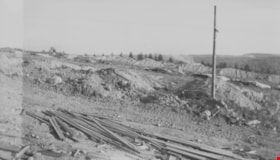
- Photograph of the 4200 block of Grant Street with cleared land with lumber in the foreground.
- Repository
- City of Burnaby Archives
- Date
- August 20, 1947
- Collection/Fonds
- Burnaby Historical Society fonds
- Subseries
- Alfred Bingham subseries
- Physical Description
- 1 photograph : b&w negative ; 6.8 x 11.6 cm
- Description Level
- Item
- Record No.
- 010-150
- Access Restriction
- No restrictions
- Reproduction Restriction
- No known restrictions
- Accession Number
- BHS2007-04
- Scope and Content
- Photograph of the 4200 block of Grant Street with cleared land with lumber in the foreground.
- Subjects
- Land Clearing
- Media Type
- Photograph
- Photographer
- Bingham, Alfred "Alf"
- Notes
- Title based on contents of photograph
- Geographic Access
- Grant Street
Images

Grant Street and Willingdon Avenue
https://search.heritageburnaby.ca/link/archivedescription34200
- Repository
- City of Burnaby Archives
- Date
- June 17, 1947
- Collection/Fonds
- Burnaby Historical Society fonds
- Description Level
- Item
- Physical Description
- 1 photograph : b&w negative ; 6.8 x 11.7 cm
- Scope and Content
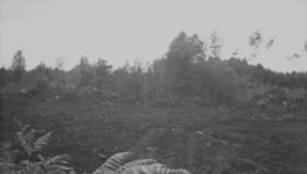
- Photograph of cleared land and brush at Grant Street and Willingdon Avenue (southeast). This is part of the Willingdon Heights subdivision site.
- Repository
- City of Burnaby Archives
- Date
- June 17, 1947
- Collection/Fonds
- Burnaby Historical Society fonds
- Subseries
- Alfred Bingham subseries
- Physical Description
- 1 photograph : b&w negative ; 6.8 x 11.7 cm
- Description Level
- Item
- Record No.
- 010-116
- Access Restriction
- No restrictions
- Reproduction Restriction
- No known restrictions
- Accession Number
- BHS2007-04
- Scope and Content
- Photograph of cleared land and brush at Grant Street and Willingdon Avenue (southeast). This is part of the Willingdon Heights subdivision site.
- Subjects
- Land Clearing
- Media Type
- Photograph
- Photographer
- Bingham, Alfred "Alf"
- Notes
- Title based on contents of photograph
- Geographic Access
- Grant Street
- Willingdon Avenue
Images

![Jack and Betty Dwyer at the lot, [1946 or 1947] (date of original), copied 1991 thumbnail](/media/hpo/_Data/_Archives_Images/_Unrestricted/370/370-221.jpg?width=280)
Jack and Betty Dwyer at the lot
https://search.heritageburnaby.ca/link/archivedescription37633
- Repository
- City of Burnaby Archives
- Date
- [1946 or 1947] (date of original), copied 1991
- Collection/Fonds
- Burnaby Historical Society fonds
- Description Level
- Item
- Physical Description
- 1 photograph : b&w ; 4.2 x 2.8 cm print on contact sheet 20.2 x 25.3 cm
- Scope and Content
- Photograph of Jack and Betty Dwyer at the lot of 202 Delta Avenue prior to construction of the house.
- Repository
- City of Burnaby Archives
- Date
- [1946 or 1947] (date of original), copied 1991
- Collection/Fonds
- Burnaby Historical Society fonds
- Subseries
- Burnaby Image Bank subseries
- Physical Description
- 1 photograph : b&w ; 4.2 x 2.8 cm print on contact sheet 20.2 x 25.3 cm
- Description Level
- Item
- Record No.
- 370-221
- Access Restriction
- No restrictions
- Reproduction Restriction
- No known restrictions
- Accession Number
- BHS1999-03
- Scope and Content
- Photograph of Jack and Betty Dwyer at the lot of 202 Delta Avenue prior to construction of the house.
- Subjects
- Land Clearing
- Names
- Dwyer, Betty
- Dwyer, Jack
- Media Type
- Photograph
- Notes
- Title based on contents of photograph
- 1 b&w copy negative accompanying
- Geographic Access
- Delta Avenue
- Street Address
- 202 Delta Avenue
- Historic Neighbourhood
- Capitol Hill (Historic Neighbourhood)
- Planning Study Area
- Capitol Hill Area
Images
![Jack and Betty Dwyer at the lot, [1946 or 1947] (date of original), copied 1991 thumbnail](/media/hpo/_Data/_Archives_Images/_Unrestricted/370/370-221.jpg)