Narrow Results By
Subject
- Animals - Dogs 1
- Buildings - Heritage 1
- Buildings - Industrial - Mills 1
- Buildings - Residences - Houses 1
- Buildings - Residential - Houses 13
- Construction 2
- Construction - Road Construction 1
- Construction Tools and Equipment 10
- Documentary Artifacts - Postcards 3
- Geographic Features - Inlets 1
- Geographic Features - Parks 1
- Geographic Features - Roads 11

Kitchener Street and William Avenue
https://search.heritageburnaby.ca/link/archivedescription34237
- Repository
- City of Burnaby Archives
- Date
- August 12, 1947
- Collection/Fonds
- Burnaby Historical Society fonds
- Description Level
- Item
- Physical Description
- 1 photograph : b&w negative ; 6.8 x 12.5 cm
- Scope and Content
- Photograph of brush and cleared land at Kitchener Street and William Street with houses visible in background. This is part of the Willingdon Heights subdivision site.
- Repository
- City of Burnaby Archives
- Date
- August 12, 1947
- Collection/Fonds
- Burnaby Historical Society fonds
- Subseries
- Alfred Bingham subseries
- Physical Description
- 1 photograph : b&w negative ; 6.8 x 12.5 cm
- Description Level
- Item
- Record No.
- 010-149
- Access Restriction
- No restrictions
- Reproduction Restriction
- No known restrictions
- Accession Number
- BHS2007-04
- Scope and Content
- Photograph of brush and cleared land at Kitchener Street and William Street with houses visible in background. This is part of the Willingdon Heights subdivision site.
- Subjects
- Land Clearing
- Geographic Features - Roads
- Media Type
- Photograph
- Photographer
- Bingham, Alfred "Alf"
- Notes
- Title based on contents of photograph
- Geographic Access
- Kitchener Street
- William Street
Images


Kitchener Street and Willingdon Avenue
https://search.heritageburnaby.ca/link/archivedescription34115
- Repository
- City of Burnaby Archives
- Date
- March 22, 1947
- Collection/Fonds
- Burnaby Historical Society fonds
- Description Level
- Item
- Physical Description
- 1 photograph : b&w negative ; 6.8 x 11.2 cm
- Scope and Content
- Photograph of Kitchener Street and Willingdon Avenue with empty land in the foreground and houses visible in the distance. This is part of the Willingdon Heights subdivision site.
- Repository
- City of Burnaby Archives
- Date
- March 22, 1947
- Collection/Fonds
- Burnaby Historical Society fonds
- Subseries
- Alfred Bingham subseries
- Physical Description
- 1 photograph : b&w negative ; 6.8 x 11.2 cm
- Description Level
- Item
- Record No.
- 010-031
- Access Restriction
- No restrictions
- Reproduction Restriction
- No known restrictions
- Accession Number
- BHS2007-04
- Scope and Content
- Photograph of Kitchener Street and Willingdon Avenue with empty land in the foreground and houses visible in the distance. This is part of the Willingdon Heights subdivision site.
- Subjects
- Land Clearing
- Media Type
- Photograph
- Photographer
- Bingham, Alfred "Alf"
- Notes
- Title based on contents of photograph
- Geographic Access
- Kitchener Street
- Willingdon Avenue
Images

Leer family
https://search.heritageburnaby.ca/link/archivedescription35195
- Repository
- City of Burnaby Archives
- Date
- 1911
- Collection/Fonds
- Burnaby Historical Society fonds
- Description Level
- Item
- Physical Description
- 1 photograph : b&w ; 12.7 x 17.8 cm print
- Scope and Content
- Photograph of the Leer family. From left to right: Richard Hedges, George Leer, Sarah Leer, and Ethel Leer. George Leer and his wife would be grandparents of Mayor William Lewarne. This photograph was taken in front of the Leer family home at Portland Street and McGregor Avenue.
- Repository
- City of Burnaby Archives
- Date
- 1911
- Collection/Fonds
- Burnaby Historical Society fonds
- Subseries
- Pioneer Tales subseries
- Physical Description
- 1 photograph : b&w ; 12.7 x 17.8 cm print
- Description Level
- Item
- Record No.
- 204-052
- Access Restriction
- No restrictions
- Reproduction Restriction
- No known restrictions
- Accession Number
- BHS1988-03
- Scope and Content
- Photograph of the Leer family. From left to right: Richard Hedges, George Leer, Sarah Leer, and Ethel Leer. George Leer and his wife would be grandparents of Mayor William Lewarne. This photograph was taken in front of the Leer family home at Portland Street and McGregor Avenue.
- Media Type
- Photograph
- Notes
- Title based on contents of photograph
- Geographic Access
- Portland Street
- McGregor Avenue
- Historic Neighbourhood
- Alta-Vista (Historic Neighbourhood)
- Planning Study Area
- Sussex-Nelson Area
Images

![Logging in Central Park, [1911] thumbnail](/media/hpo/_Data/_Archives_Images/_Unrestricted/371/449-005.jpg?width=280)
Logging in Central Park
https://search.heritageburnaby.ca/link/archivedescription38510
- Repository
- City of Burnaby Archives
- Date
- [1911]
- Collection/Fonds
- Burnaby Historical Society fonds
- Description Level
- Item
- Physical Description
- 1 photograph : b&w postcard ; 8 x 13.4 cm
- Scope and Content
- Photograph of two men logging in Central Park. The man on the left is Evan Baker but the other man is unidentified.
- Repository
- City of Burnaby Archives
- Date
- [1911]
- Collection/Fonds
- Burnaby Historical Society fonds
- Subseries
- Photographs subseries
- Physical Description
- 1 photograph : b&w postcard ; 8 x 13.4 cm
- Description Level
- Item
- Record No.
- 449-005
- Access Restriction
- No restrictions
- Reproduction Restriction
- No known restrictions
- Accession Number
- BHS2007-04
- Scope and Content
- Photograph of two men logging in Central Park. The man on the left is Evan Baker but the other man is unidentified.
- Subjects
- Land Clearing
- Documentary Artifacts - Postcards
- Occupations - Lumberjacks
- Woodworking Tools and Equipment
- Names
- Baker, Evan
- Media Type
- Photograph
- Notes
- Title based on contents of photograph
- Geographic Access
- Central Park
- Imperial Street
- Street Address
- 3883 Imperial Street
- Historic Neighbourhood
- Central Park (Historic Neighbourhood)
- Planning Study Area
- Maywood Area
Images
![Logging in Central Park, [1911] thumbnail](/media/hpo/_Data/_Archives_Images/_Unrestricted/371/449-005.jpg)
![Lot clearing for Westminster Gospel Chapel, [between 1945 and 1949] (date of original), copied 1991 thumbnail](/media/hpo/_Data/_Archives_Images/_Unrestricted/370/370-415.jpg?width=280)
Lot clearing for Westminster Gospel Chapel
https://search.heritageburnaby.ca/link/archivedescription37827
- Repository
- City of Burnaby Archives
- Date
- [between 1945 and 1949] (date of original), copied 1991
- Collection/Fonds
- Burnaby Historical Society fonds
- Description Level
- Item
- Physical Description
- 1 photograph : b&w ; 2.7 x 4.7 cm print on contact sheet 20.6 x 26.2 cm
- Scope and Content
- Photograph of people clearing a lot to build Westminster Gospel Chapel at 7540 6th Street.
- Repository
- City of Burnaby Archives
- Date
- [between 1945 and 1949] (date of original), copied 1991
- Collection/Fonds
- Burnaby Historical Society fonds
- Subseries
- Burnaby Image Bank subseries
- Physical Description
- 1 photograph : b&w ; 2.7 x 4.7 cm print on contact sheet 20.6 x 26.2 cm
- Description Level
- Item
- Record No.
- 370-415
- Access Restriction
- No restrictions
- Reproduction Restriction
- No known restrictions
- Accession Number
- BHS1999-03
- Scope and Content
- Photograph of people clearing a lot to build Westminster Gospel Chapel at 7540 6th Street.
- Subjects
- Land Clearing
- Media Type
- Photograph
- Notes
- Title based on contents of photograph
- 1 b&w copy negative accompanying
- Negative has a pink cast
- Geographic Access
- 6th Street
- Street Address
- 7540 6th Street
- Historic Neighbourhood
- East Burnaby (Historic Neighbourhood)
- Planning Study Area
- Second Street Area
Images
![Lot clearing for Westminster Gospel Chapel, [between 1945 and 1949] (date of original), copied 1991 thumbnail](/media/hpo/_Data/_Archives_Images/_Unrestricted/370/370-415.jpg)
![Lot clearing for Westminster Gospel Chapel, [between 1945 and 1949] (date of original), copied 1991 thumbnail](/media/hpo/_Data/_Archives_Images/_Unrestricted/370/370-416.jpg?width=280)
Lot clearing for Westminster Gospel Chapel
https://search.heritageburnaby.ca/link/archivedescription37828
- Repository
- City of Burnaby Archives
- Date
- [between 1945 and 1949] (date of original), copied 1991
- Collection/Fonds
- Burnaby Historical Society fonds
- Description Level
- Item
- Physical Description
- 1 photograph : b&w ; 2.6 x 4.7 cm print on contact sheet 20.6 x 26.2 cm
- Scope and Content
- Photograph of people clearing a lot to build Westminster Gospel Chapel at 7540 6th Street. Houses can be seen in the background, and the road can be seen in the foreground.
- Repository
- City of Burnaby Archives
- Date
- [between 1945 and 1949] (date of original), copied 1991
- Collection/Fonds
- Burnaby Historical Society fonds
- Subseries
- Burnaby Image Bank subseries
- Physical Description
- 1 photograph : b&w ; 2.6 x 4.7 cm print on contact sheet 20.6 x 26.2 cm
- Description Level
- Item
- Record No.
- 370-416
- Access Restriction
- No restrictions
- Reproduction Restriction
- No known restrictions
- Accession Number
- BHS1999-03
- Scope and Content
- Photograph of people clearing a lot to build Westminster Gospel Chapel at 7540 6th Street. Houses can be seen in the background, and the road can be seen in the foreground.
- Subjects
- Land Clearing
- Media Type
- Photograph
- Notes
- Title based on contents of photograph
- 1 b&w copy negative accompanying
- Negative has a pink cast
- Geographic Access
- 6th Street
- Street Address
- 7540 6th Street
- Historic Neighbourhood
- East Burnaby (Historic Neighbourhood)
- Planning Study Area
- Second Street Area
Images
![Lot clearing for Westminster Gospel Chapel, [between 1945 and 1949] (date of original), copied 1991 thumbnail](/media/hpo/_Data/_Archives_Images/_Unrestricted/370/370-416.jpg)

Madison Avenue
https://search.heritageburnaby.ca/link/archivedescription34243
- Repository
- City of Burnaby Archives
- Date
- August 20, 1947
- Collection/Fonds
- Burnaby Historical Society fonds
- Description Level
- Item
- Physical Description
- 1 photograph : b&w negative ; 6.8 x 11.4 cm
- Scope and Content
- Photograph of Madison Avenue (east) with the road and cleared land in the foreground, and houses in the background. This is part of the Willingdon Heights subdivision site.
- Repository
- City of Burnaby Archives
- Date
- August 20, 1947
- Collection/Fonds
- Burnaby Historical Society fonds
- Subseries
- Alfred Bingham subseries
- Physical Description
- 1 photograph : b&w negative ; 6.8 x 11.4 cm
- Description Level
- Item
- Record No.
- 010-155
- Access Restriction
- No restrictions
- Reproduction Restriction
- No known restrictions
- Accession Number
- BHS2007-04
- Scope and Content
- Photograph of Madison Avenue (east) with the road and cleared land in the foreground, and houses in the background. This is part of the Willingdon Heights subdivision site.
- Media Type
- Photograph
- Photographer
- Bingham, Alfred "Alf"
- Notes
- Title based on contents of photograph
- Geographic Access
- Madison Avenue
Images


Madison Avenue
https://search.heritageburnaby.ca/link/archivedescription34244
- Repository
- City of Burnaby Archives
- Date
- August 20, 1947
- Collection/Fonds
- Burnaby Historical Society fonds
- Description Level
- Item
- Physical Description
- 1 photograph : b&w negative ; 6.8 x 11.4 cm
- Scope and Content
- Photograph of Madison Avenue (southeast) with the road and cleared land in the foreground, and houses in the background. This is part of the Willingdon Heights subdivision site.
- Repository
- City of Burnaby Archives
- Date
- August 20, 1947
- Collection/Fonds
- Burnaby Historical Society fonds
- Subseries
- Alfred Bingham subseries
- Physical Description
- 1 photograph : b&w negative ; 6.8 x 11.4 cm
- Description Level
- Item
- Record No.
- 010-156
- Access Restriction
- No restrictions
- Reproduction Restriction
- No known restrictions
- Accession Number
- BHS2007-04
- Scope and Content
- Photograph of Madison Avenue (southeast) with the road and cleared land in the foreground, and houses in the background. This is part of the Willingdon Heights subdivision site.
- Media Type
- Photograph
- Photographer
- Bingham, Alfred "Alf"
- Notes
- Title based on contents of photograph
- Geographic Access
- Madison Avenue
Images

Madison Avenue and Kitchener Street
https://search.heritageburnaby.ca/link/archivedescription34151
- Repository
- City of Burnaby Archives
- Date
- April 22, 1947
- Collection/Fonds
- Burnaby Historical Society fonds
- Description Level
- Item
- Physical Description
- 1 photograph : b&w negative ; 6.8 x 11.3 cm
- Scope and Content
- Photograph of land clearing at Madison Avenue and Kitchener Street. A building can be seen in the background. This is part of the Willingdon Heights subdivision site.
- Repository
- City of Burnaby Archives
- Date
- April 22, 1947
- Collection/Fonds
- Burnaby Historical Society fonds
- Subseries
- Alfred Bingham subseries
- Physical Description
- 1 photograph : b&w negative ; 6.8 x 11.3 cm
- Description Level
- Item
- Record No.
- 010-068
- Access Restriction
- No restrictions
- Reproduction Restriction
- No known restrictions
- Accession Number
- BHS2007-04
- Scope and Content
- Photograph of land clearing at Madison Avenue and Kitchener Street. A building can be seen in the background. This is part of the Willingdon Heights subdivision site.
- Subjects
- Land Clearing
- Media Type
- Photograph
- Photographer
- Bingham, Alfred "Alf"
- Notes
- Title based on contents of photograph
- Geographic Access
- Madison Avenue
- Kitchener Street
Images

Madison Avenue and Kitchener Street
https://search.heritageburnaby.ca/link/archivedescription34240
- Repository
- City of Burnaby Archives
- Date
- August 20, 1947
- Collection/Fonds
- Burnaby Historical Society fonds
- Description Level
- Item
- Physical Description
- 1 photograph : b&w negative ; 6.8 x 13.1 cm
- Scope and Content
- Photograph of the 4200 block of Kitchener Street at Madison Avenue with cleared land and brush in foreground, and a bulldozer, lumber and houses under construction in background. This is part of the Willingdon Heights subdivision site.
- Repository
- City of Burnaby Archives
- Date
- August 20, 1947
- Collection/Fonds
- Burnaby Historical Society fonds
- Subseries
- Alfred Bingham subseries
- Physical Description
- 1 photograph : b&w negative ; 6.8 x 13.1 cm
- Description Level
- Item
- Record No.
- 010-152
- Access Restriction
- No restrictions
- Reproduction Restriction
- No known restrictions
- Accession Number
- BHS2007-04
- Scope and Content
- Photograph of the 4200 block of Kitchener Street at Madison Avenue with cleared land and brush in foreground, and a bulldozer, lumber and houses under construction in background. This is part of the Willingdon Heights subdivision site.
- Media Type
- Photograph
- Photographer
- Bingham, Alfred "Alf"
- Notes
- Title based on contents of photograph
- Geographic Access
- Kitchener Street
Images

![Man on a bulldozer, [194-] thumbnail](/media/hpo/_Data/_BVM_Images/1971/197100120077.jpg?width=280)
Man on a bulldozer
https://search.heritageburnaby.ca/link/museumdescription9
- Repository
- Burnaby Village Museum
- Date
- [194-]
- Collection/Fonds
- Burnaby Village Museum Photograph collection
- Description Level
- Item
- Physical Description
- 1 photograph : b&w ; 6.9 x 11.4 cm
- Scope and Content
- Photograph of an unidentified man, possibly the operator, is standing on a bulldozer belonging to "Holmes & Wilson Trucking". Lumber stacks are nearby, and the bulldozer is on a clearing for a house lot. This may be related to the construction of the Willingdon Heights subdivision. Stamped on bac…
- Repository
- Burnaby Village Museum
- Collection/Fonds
- Burnaby Village Museum Photograph collection
- Description Level
- Item
- Physical Description
- 1 photograph : b&w ; 6.9 x 11.4 cm
- Scope and Content
- Photograph of an unidentified man, possibly the operator, is standing on a bulldozer belonging to "Holmes & Wilson Trucking". Lumber stacks are nearby, and the bulldozer is on a clearing for a house lot. This may be related to the construction of the Willingdon Heights subdivision. Stamped on back of photo: "342X."
- Names
- Bingham, Alfred "Alf"
- Accession Code
- HV971.12.77
- Access Restriction
- No restrictions
- Reproduction Restriction
- No known restrictions
- Date
- [194-]
- Media Type
- Photograph
- Historic Neighbourhood
- Vancouver Heights (Historic Neighbourhood)
- Planning Study Area
- Willingdon Heights Area
- Scan Resolution
- 600
- Scan Date
- 2023-03-21
- Notes
- Title based on contents of photograph
Images
![Man on a bulldozer, [194-] thumbnail](/media/hpo/_Data/_BVM_Images/1971/197100120077.jpg)
![Man on a bulldozer, [194-] thumbnail](/media/hpo/_Data/_BVM_Images/1971/197100120078.jpg?width=280)
Man on a bulldozer
https://search.heritageburnaby.ca/link/museumdescription10
- Repository
- Burnaby Village Museum
- Date
- [194-]
- Collection/Fonds
- Burnaby Village Museum Photograph collection
- Description Level
- Item
- Physical Description
- 1 photograph : b&w ; 6.9 x 11.9 cm
- Scope and Content
- Photograph of an unidentified man standing on a bulldozer belonging to "Wm. Edstrom" as written on the machine. The bulldozer is on a clearing nearby houses. This may be related to the construction of the Willingdon Heights subdivision. Stamped on back of the photograph: "342X."
- Repository
- Burnaby Village Museum
- Collection/Fonds
- Burnaby Village Museum Photograph collection
- Description Level
- Item
- Physical Description
- 1 photograph : b&w ; 6.9 x 11.9 cm
- Scope and Content
- Photograph of an unidentified man standing on a bulldozer belonging to "Wm. Edstrom" as written on the machine. The bulldozer is on a clearing nearby houses. This may be related to the construction of the Willingdon Heights subdivision. Stamped on back of the photograph: "342X."
- Names
- Bingham, Alfred "Alf"
- Accession Code
- HV971.12.78
- Access Restriction
- No restrictions
- Reproduction Restriction
- No known restrictions
- Date
- [194-]
- Media Type
- Photograph
- Historic Neighbourhood
- Vancouver Heights (Historic Neighbourhood)
- Planning Study Area
- Willingdon Heights Area
- Scan Resolution
- 600
- Scan Date
- 2023-03-21
- Notes
- Title based on contents of photograph
Images
![Man on a bulldozer, [194-] thumbnail](/media/hpo/_Data/_BVM_Images/1971/197100120078.jpg)
![Man on a bulldozer, [194-] thumbnail](/media/hpo/_Data/_BVM_Images/1971/197100120080.jpg?width=280)
Man on a bulldozer
https://search.heritageburnaby.ca/link/museumdescription12
- Repository
- Burnaby Village Museum
- Date
- [194-]
- Collection/Fonds
- Burnaby Village Museum Photograph collection
- Description Level
- Item
- Physical Description
- 1 photograph : b&w ; 6.8 x 11.3 cm
- Scope and Content
- Photograph of an unidentified man standing on a bulldozer. The bulldozer is on a cleared lot, behind which houses and electric posts along a road can be seen. This may be the site of the Willingdon Heights subdivision. Stamped on the back of the photograph: "345L."
- Repository
- Burnaby Village Museum
- Collection/Fonds
- Burnaby Village Museum Photograph collection
- Description Level
- Item
- Physical Description
- 1 photograph : b&w ; 6.8 x 11.3 cm
- Scope and Content
- Photograph of an unidentified man standing on a bulldozer. The bulldozer is on a cleared lot, behind which houses and electric posts along a road can be seen. This may be the site of the Willingdon Heights subdivision. Stamped on the back of the photograph: "345L."
- Names
- Bingham, Alfred "Alf"
- Accession Code
- HV971.12.80
- Access Restriction
- No restrictions
- Reproduction Restriction
- No known restrictions
- Date
- [194-]
- Media Type
- Photograph
- Historic Neighbourhood
- Vancouver Heights (Historic Neighbourhood)
- Planning Study Area
- Willingdon Heights Area
- Related Material
- the unidentified man in the photograph reappears in photograph HV971.12.81
- Scan Resolution
- 600
- Scan Date
- 2023-03-21
- Notes
- Title based on contents of photograph
Images
![Man on a bulldozer, [194-] thumbnail](/media/hpo/_Data/_BVM_Images/1971/197100120080.jpg)
Napier Street
https://search.heritageburnaby.ca/link/archivedescription34172
- Repository
- City of Burnaby Archives
- Date
- May 9, 1947
- Collection/Fonds
- Burnaby Historical Society fonds
- Description Level
- Item
- Physical Description
- 1 photograph : b&w negative ; 6.8 x 11.2 cm
- Scope and Content
- Photograph of cleared land at the 4400 Block of Napier Street (south) with houses visible in the background. This is part of the Willingdon Heights subdivision site.
- Repository
- City of Burnaby Archives
- Date
- May 9, 1947
- Collection/Fonds
- Burnaby Historical Society fonds
- Subseries
- Alfred Bingham subseries
- Physical Description
- 1 photograph : b&w negative ; 6.8 x 11.2 cm
- Description Level
- Item
- Record No.
- 010-089
- Access Restriction
- No restrictions
- Reproduction Restriction
- No known restrictions
- Accession Number
- BHS2007-04
- Scope and Content
- Photograph of cleared land at the 4400 Block of Napier Street (south) with houses visible in the background. This is part of the Willingdon Heights subdivision site.
- Subjects
- Land Clearing
- Media Type
- Photograph
- Photographer
- Bingham, Alfred "Alf"
- Notes
- Title based on contents of photograph
- Geographic Access
- Napier Street
Images
![Newly constructed house, [between 1910 and 1914] thumbnail](/media/hpo/_Data/_Archives_Images/_Unrestricted/487/487-015.jpg?width=280)
Newly constructed house
https://search.heritageburnaby.ca/link/archivedescription57711
- Repository
- City of Burnaby Archives
- Date
- [between 1910 and 1914]
- Collection/Fonds
- J.W. Phillips fonds
- Description Level
- Item
- Physical Description
- 1 photograph : b&w glass negative ; 11 x 15.5 cm
- Scope and Content
- Photograph of a man sitting at the side of a newly constructed house, most likely in the Capitol Hill neighbourhood of Burnaby.
- Repository
- City of Burnaby Archives
- Date
- [between 1910 and 1914]
- Collection/Fonds
- J.W. Phillips fonds
- Physical Description
- 1 photograph : b&w glass negative ; 11 x 15.5 cm
- Material Details
- Emulsion measures 11 x 15.5 cm on the glass; entire glass plate measures 12 x 16 cm
- Description Level
- Item
- Record No.
- 487-015
- Access Restriction
- No restrictions
- Reproduction Restriction
- No known restrictions
- Accession Number
- 2008-18
- Scope and Content
- Photograph of a man sitting at the side of a newly constructed house, most likely in the Capitol Hill neighbourhood of Burnaby.
- Media Type
- Photograph
- Photographer
- Phillips, James William "Jim"
- Notes
- Title based on contents of photograph
- Historic Neighbourhood
- Central Park (Historic Neighbourhood)
- Planning Study Area
- Capitol Hill Area
Images
![Newly constructed house, [between 1910 and 1914] thumbnail](/media/hpo/_Data/_Archives_Images/_Unrestricted/487/487-015.jpg)
![Paved road, [1948] thumbnail](/media/hpo/_Data/_BVM_Images/1971/1971_0012_0087_001.jpg?width=280)
Paved road
https://search.heritageburnaby.ca/link/museumdescription19
- Repository
- Burnaby Village Museum
- Date
- [1948]
- Collection/Fonds
- Burnaby Village Museum Photograph collection
- Description Level
- Item
- Physical Description
- 1 photograph : sepia ; 6.8 x 11.4 cm
- Scope and Content
- Photograph of a paved road running through a cleared lot. There is an electric post on the roadside, and woods in the background. Catalogue information from 1976 indicates that it is a street development in Burnaby, ca. 1948. This may be the site of the Willingdon Heights subdivision. Annotation o…
- Repository
- Burnaby Village Museum
- Collection/Fonds
- Burnaby Village Museum Photograph collection
- Description Level
- Item
- Physical Description
- 1 photograph : sepia ; 6.8 x 11.4 cm
- Scope and Content
- Photograph of a paved road running through a cleared lot. There is an electric post on the roadside, and woods in the background. Catalogue information from 1976 indicates that it is a street development in Burnaby, ca. 1948. This may be the site of the Willingdon Heights subdivision. Annotation on lower right front of photograph: "26." Stamped on back of photograph: "321X."
- Subjects
- Geographic Features - Roads
- Land Clearing
- Names
- Bingham, Alfred "Alf"
- Accession Code
- HV971.12.87
- Access Restriction
- No restrictions
- Reproduction Restriction
- No known restrictions
- Date
- [1948]
- Media Type
- Photograph
- Historic Neighbourhood
- Vancouver Heights (Historic Neighbourhood)
- Planning Study Area
- Willingdon Heights Area
- Scan Resolution
- 600
- Scan Date
- 2023-03-21
- Notes
- Title based on contents of photograph
Images
![Paved road, [1948] thumbnail](/media/hpo/_Data/_BVM_Images/1971/1971_0012_0087_001.jpg)
Ready to blast
https://search.heritageburnaby.ca/link/archivedescription34158
- Repository
- City of Burnaby Archives
- Date
- April 25, 1947
- Collection/Fonds
- Burnaby Historical Society fonds
- Description Level
- Item
- Physical Description
- 1 photograph : b&w negative ; 6.8 x 11.3 cm
- Scope and Content
- Photograph(s) restricted for commercial use under FOIPPA. Review for the amount of personal information depicted in the photograph(s) in relation to the researcher's intended use.
- Repository
- City of Burnaby Archives
- Date
- April 25, 1947
- Collection/Fonds
- Burnaby Historical Society fonds
- Subseries
- Alfred Bingham subseries
- Physical Description
- 1 photograph : b&w negative ; 6.8 x 11.3 cm
- Description Level
- Item
- Record No.
- 010-075
- Access Restriction
- No restrictions
- Reproduction Restriction
- Reproduce for fair dealing purposes only
- Accession Number
- BHS2007-04
- Scope and Content
- Photograph(s) restricted for commercial use under FOIPPA. Review for the amount of personal information depicted in the photograph(s) in relation to the researcher's intended use.
- Permission of the estate of Alfred "Alf" Bingham required to reproduce for purposes other than fair dealing. Copyright expires in 2050. Contact information (if available) located in accession record.
- Media Type
- Photograph
- Photographer
- Bingham, Alfred "Alf"
- Notes
- Title based on contents of photograph
Images
Rock crusher in operation
https://search.heritageburnaby.ca/link/archivedescription39573
- Repository
- City of Burnaby Archives
- Date
- August 1910
- Collection/Fonds
- Peers Family and Hill Family fonds
- Description Level
- Item
- Physical Description
- 1 photograph : b&w ; 7.5 x 10.2 cm on page 21.5 x 28 cm (pasted in album)
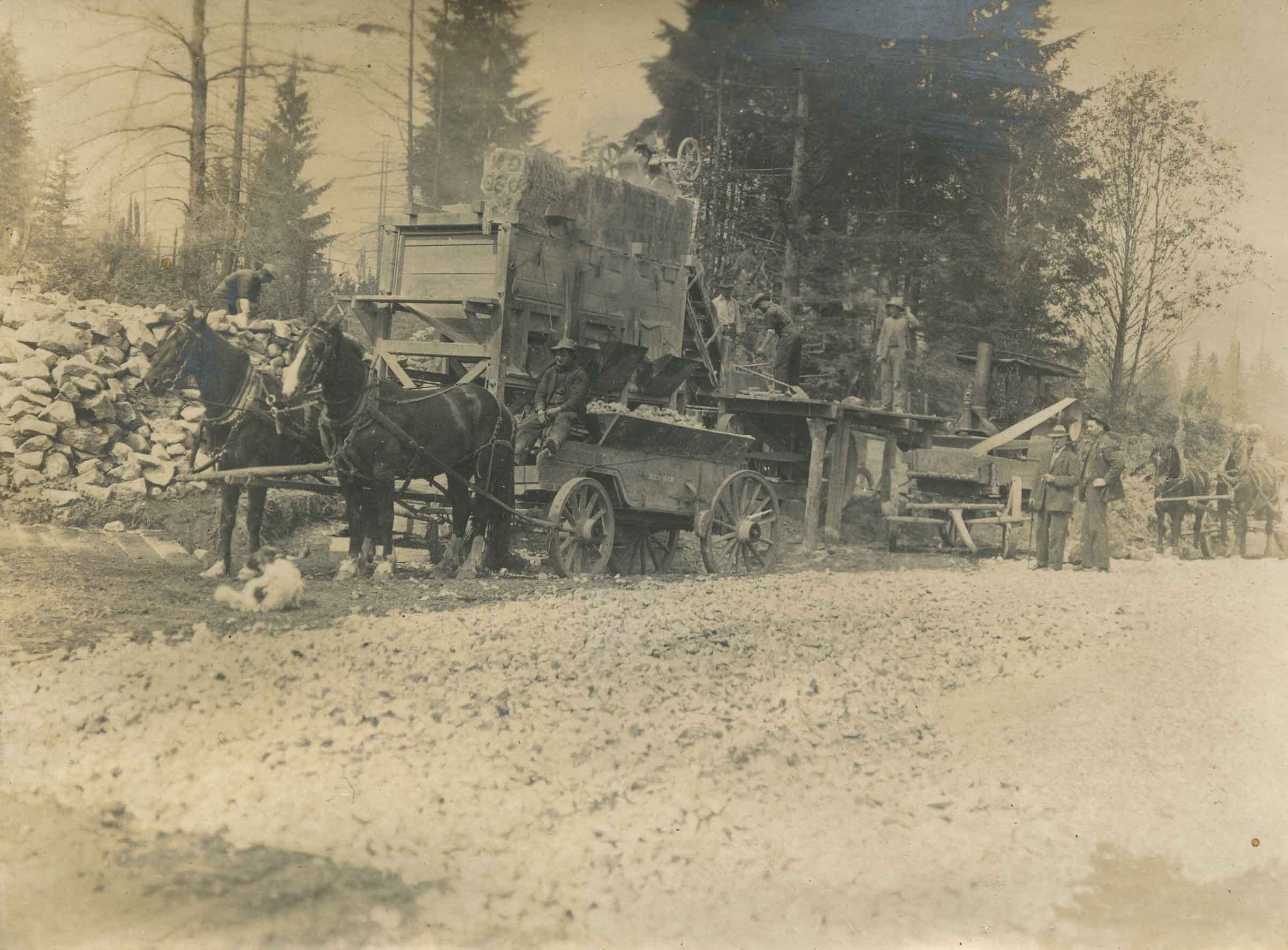
- Scope and Content
- Photograph of a rock crusher in operation. From a wall of rocks, a team of men puts the rock into the rock crusher. The crushed gravel is loaded up in a horse drawn cart, with a driver ready to transport it away. There are two men in suits to the right of the photograph watching the operation.
- Repository
- City of Burnaby Archives
- Date
- August 1910
- Collection/Fonds
- Peers Family and Hill Family fonds
- Physical Description
- 1 photograph : b&w ; 7.5 x 10.2 cm on page 21.5 x 28 cm (pasted in album)
- Description Level
- Item
- Record No.
- 477-892
- Access Restriction
- No restrictions
- Reproduction Restriction
- No known restrictions
- Accession Number
- 2007-12
- Scope and Content
- Photograph of a rock crusher in operation. From a wall of rocks, a team of men puts the rock into the rock crusher. The crushed gravel is loaded up in a horse drawn cart, with a driver ready to transport it away. There are two men in suits to the right of the photograph watching the operation.
- Names
- Oakalla Prison Farm
- Media Type
- Photograph
- Notes
- Title based on contents of photograph
- Geographic Access
- Oakmount Crescent
- Street Address
- 5220 Oakmount Crescent
- Historic Neighbourhood
- Burnaby Lake (Historic Neighbourhood)
- Planning Study Area
- Oakalla Area
Images
Rosser Avenue
https://search.heritageburnaby.ca/link/archivedescription34187
- Repository
- City of Burnaby Archives
- Date
- May 26, 1947
- Collection/Fonds
- Burnaby Historical Society fonds
- Description Level
- Item
- Physical Description
- 1 photograph : b&w negative ; 6.8 x 11.4 cm
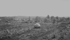
- Scope and Content
- Photograph of a boulder on cleared land with brush in the background on Rosser Avenue. This is part of the Willingdon Heights subdivision site.
- Repository
- City of Burnaby Archives
- Date
- May 26, 1947
- Collection/Fonds
- Burnaby Historical Society fonds
- Subseries
- Alfred Bingham subseries
- Physical Description
- 1 photograph : b&w negative ; 6.8 x 11.4 cm
- Description Level
- Item
- Record No.
- 010-104
- Access Restriction
- No restrictions
- Reproduction Restriction
- No known restrictions
- Accession Number
- BHS2007-04
- Scope and Content
- Photograph of a boulder on cleared land with brush in the background on Rosser Avenue. This is part of the Willingdon Heights subdivision site.
- Subjects
- Land Clearing
- Media Type
- Photograph
- Photographer
- Bingham, Alfred "Alf"
- Notes
- Title based on contents of photograph
- Geographic Access
- Rosser Avenue
Images


Rosser Avenue and Napier Street
https://search.heritageburnaby.ca/link/archivedescription34119
- Repository
- City of Burnaby Archives
- Date
- March 29, 1947
- Collection/Fonds
- Burnaby Historical Society fonds
- Description Level
- Item
- Physical Description
- 1 photograph : b&w negative ; 6.8 x 11.2 cm
- Scope and Content
- Photograph of Rosser Avenue and Napier Street with a cleared area with a house on either side. This is part of the Willingdon Heights subdivision site.
- Repository
- City of Burnaby Archives
- Date
- March 29, 1947
- Collection/Fonds
- Burnaby Historical Society fonds
- Subseries
- Alfred Bingham subseries
- Physical Description
- 1 photograph : b&w negative ; 6.8 x 11.2 cm
- Description Level
- Item
- Record No.
- 010-035
- Access Restriction
- No restrictions
- Reproduction Restriction
- No known restrictions
- Accession Number
- BHS2007-04
- Scope and Content
- Photograph of Rosser Avenue and Napier Street with a cleared area with a house on either side. This is part of the Willingdon Heights subdivision site.
- Media Type
- Photograph
- Photographer
- Bingham, Alfred "Alf"
- Notes
- Title based on contents of photograph
- Geographic Access
- Rosser Avenue
- Napier Street
Images
