Narrow Results By
Subject
- Advertising Medium - Signs and Signboards 1
- Agriculture - Farms 2
- Buildings - Commercial - Restaurants 1
- Clothing - Uniforms 4
- Events - May Day 11
- Events - Parades 2
- Geographic Features - Lakes and Ponds 1
- Geographic Features - Mountains - British Columbia 1
- Geographic Features - Parks 1
- Geographic Features - Roads 1
- Land Clearing 1
- Musical Instruments - Bagpipes 1

Arrow Neon Sign
https://search.heritageburnaby.ca/link/landmark861
- Repository
- Burnaby Heritage Planning
- Description
- Commercial building.
- Associated Dates
- 1961
- Other Names
- Lost in the 50's Drive-in
- Street View URL
- Google Maps Street View
- Repository
- Burnaby Heritage Planning
- Other Names
- Lost in the 50's Drive-in
- Geographic Access
- Edmonds Street
- Associated Dates
- 1961
- Description
- Commercial building.
- Heritage Value
- The Arrow Neon Sign was built in 1961 by the Neonette Sign Company of New Westminster when this property was opened as the Tomahawk Drive-in Restaurant. The restaurant was later known as Lindy's Burger and in 1990, the business was renamed Lost in the 50's Drive-in. It stands 20-foot tall and is composed of a large double-sided hollow steel panel serpentine arrow mounted on a pole supporting a lexan sign panel measuring approximately 8 feet wide by 4 feet tall. The sign was designed with three illuminated features: a round lamp at the top of the pole, a double-sided rectangular fluorescent sign panel box, and two double-sided rows of orange neon arrows that follow the large serpentine arrow. The Arrow Neon Sign remains as a rare surviving example of neon sign art in the city and is the only historic neon sign in South Burnaby. The sign has gained prominence over the years as it has been associated with this small iconic drive-in which has also been utilized as a set for film production. Additionally, the drive-in has played a prominent role in the Edmonds community as a popular setting for recent "Show and Shine" participants to park their classic cars.
- Locality
- Edmonds
- Historic Neighbourhood
- East Burnaby (Historic Neighbourhood)
- Planning Study Area
- Lakeview-Mayfield Area
- Builder
- Neonette Sign Company
- Community
- Burnaby
- Contributing Resource
- Structure
- Ownership
- Public (local)
- Street Address
- 7741 Edmonds Street
- Street View URL
- Google Maps Street View
Images


Arthur Long Residence
https://search.heritageburnaby.ca/link/landmark560
- Repository
- Burnaby Heritage Planning
- Description
- Residential building.
- Associated Dates
- 1912
- Street View URL
- Google Maps Street View
- Repository
- Burnaby Heritage Planning
- Geographic Access
- Stanley Street
- Associated Dates
- 1912
- Description
- Residential building.
- Heritage Value
- Arthur Long, of the Water Rights Office of Victoria, purchased this land from neighbour Henry Ramsay, and built this beautiful Arts and Crafts styled home. The house appears to have many similarities to the neighbouring Ramsay House, which was designed by Vancouver architect R. Mackay Fripp. The house has retained its original complex gabled roof, triangular eave brackets and horizontal siding.
- Locality
- Burnaby Lake
- Historic Neighbourhood
- Burnaby Lake (Historic Neighbourhood)
- Planning Study Area
- Lakeview-Mayfield Area
- Ownership
- Private
- Street Address
- 7828 Stanley Street
- Street View URL
- Google Maps Street View
Images


Burnaby Lake Neighbourhood
https://search.heritageburnaby.ca/link/landmark755
- Repository
- Burnaby Heritage Planning
- Associated Dates
- 1905-1924
- Heritage Value
- Along with logging and sawmills, Burnaby became known as a prime agricultural area and the Burnaby Lake Neighbourhood saw the development of many vegetable and fruit farms. Growers in the Burnaby and Deer Lake districts took their produce to the tram line on Edmonds Street and shipped it to markets in New Westminster and Vancouver on a specially designed interurban freight car that was open-sided for easy loading. The car's canvas curtains which sometimes came loose and flapped like wings in the wind led people to dub it "the flying dutchman." Most Burnaby fruit and vegetable growers depended on seasonal Chinese work forces and other local Chinese farm residents to oversee operations; these workers being recruited from New Westminsters' Asian community. Besides being good farmers, Burnaby Lake's early residents fostered a strong sense of community. Both L. Claude Hill and his brother Bernard were elected to Burnaby Municipal council and Bernard was the one who knocked on doors to find enough children to meet the qualifications for establishing a school in the district.
- Historic Neighbourhood
- Burnaby Lake (Historic Neighbourhood)
- Planning Study Area
- Morley-Buckingham Area
- Lakeview-Mayfield Area
Images


Henry & Elsa Ramsay Residence
https://search.heritageburnaby.ca/link/landmark592
- Repository
- Burnaby Heritage Planning
- Description
- Residential building.
- Associated Dates
- 1912
- Street View URL
- Google Maps Street View
- Repository
- Burnaby Heritage Planning
- Geographic Access
- Stanley Street
- Associated Dates
- 1912
- Description
- Residential building.
- Heritage Value
- This house was built for Henry Ramsay and his wife, Elsa Kirby (née Burnett), who were married at Holy Trinity Cathedral in New Westminster in 1910. Henry was a real estate agent, originally from Newcastle-on-Tyne, England. Beautifully designed in the Arts and Crafts style, it follows the ideals of the movement in the use of native materials. The wooden construction includes timber porch and roof brackets. The roofline is of a notably low pitch. English-born architect Robert Mackay Fripp (1858-1917) had a varied career working at various times in England, New Zealand and Los Angeles. Fripp found the opportunity in British Columbia to promote his passion for British Arts and Crafts aesthetics through a series of residential and institutional commissions. The Ramsay Residence was built at the height of the Arts and Crafts movement, and Fripp’s output during this period was prolific; his residential designs ranged from modest California bungalows to stately Tudor Revival homes in Shaughnessy, Point Grey and Kerrisdale. This elegant house was built by contractor C.G. Bowden.
- Locality
- Burnaby Lake
- Historic Neighbourhood
- Burnaby Lake (Historic Neighbourhood)
- Planning Study Area
- Lakeview-Mayfield Area
- Architect
- Robert Mackay Fripp
- Area
- 1211.15
- Contributing Resource
- Building
- Ownership
- Private
- Street Address
- 7864 Stanley Street
- Street View URL
- Google Maps Street View
Images


Lakeview Elementary School
https://search.heritageburnaby.ca/link/landmark834
- Repository
- Burnaby Heritage Planning
- Geographic Access
- Mayfield Street
- Associated Dates
- 1958
- Heritage Value
- The Burnaby School Inspector's report of 1955 estimated that by 1960, the total enrolment in Burnaby would go up by over 8000 pupils. As a result, new schools needed to be built to manage this increase, Lakeview being only one of many. Lakeview opened in 1958 with 193 students. Additions to the school were made in 1965 and 1969.
- Historic Neighbourhood
- Burnaby Lake (Historic Neighbourhood)
- Planning Study Area
- Lakeview-Mayfield Area
- Street Address
- 7777 Mayfield Street
- Street View URL
- Google Maps Street View
Images


Lakeview-Mayfield Neighbourhood
https://search.heritageburnaby.ca/link/landmark830
- Repository
- Burnaby Heritage Planning
- Associated Dates
- 1955-2008
- Heritage Value
- Like many other areas of the City, the Lakeview-Mayfield Neighbourhood was subdivided during the 1950s post-war building boom. Pockets of newer homes were built in the 1970s, and the neighbourhood retained its character as a primarily residential area. The neighbourhood is bordered to the east by Robert Burnaby Park.
- Planning Study Area
- Lakeview-Mayfield Area
Images

![20th Brownie pack of Lakeview District, [between 1964 and 1969] thumbnail](/media/hpo/_Data/_BVM_Images/2016/2016_0049_0110_001.jpg?width=280)
20th Brownie pack of Lakeview District
https://search.heritageburnaby.ca/link/museumdescription5200
- Repository
- Burnaby Village Museum
- Date
- [between 1964 and 1969]
- Collection/Fonds
- Burnaby Girl Guides fonds
- Description Level
- Item
- Physical Description
- 1 photograph : b&w ; 9 x 11.5 cm
- Scope and Content
- Photograph of a group of unidentified Brownies from the 20th Lakeview District seated together for a group photograph following an enrolment and awards ceremony. This event took place preceding a gathering at Robert Burnaby Park where 125 Brownies from the 20th, 21st, 38th, 40th and 44th all parti…
- Repository
- Burnaby Village Museum
- Collection/Fonds
- Burnaby Girl Guides fonds
- Description Level
- Item
- Physical Description
- 1 photograph : b&w ; 9 x 11.5 cm
- Scope and Content
- Photograph of a group of unidentified Brownies from the 20th Lakeview District seated together for a group photograph following an enrolment and awards ceremony. This event took place preceding a gathering at Robert Burnaby Park where 125 Brownies from the 20th, 21st, 38th, 40th and 44th all participated in a pirate themed revel organized by District Commissioner Mrs. E.R. Hawkins. This photograph was part of a scrapbook titled "Lakeview_District_Girl_Guide_Association". The scrapbook may have belonged to Mrs. H. Egelstad.
- Accession Code
- BV016.49.110
- Access Restriction
- No restrictions
- Reproduction Restriction
- May be restricted by third party rights
- Date
- [between 1964 and 1969]
- Media Type
- Photograph
- Historic Neighbourhood
- Burnaby Lake (Historic Neighbourhood)
- Planning Study Area
- Lakeview-Mayfield Area
- Notes
- Title based on contents of a newspaper article
- Stamp on verso of photograph reads: "M604061"
Images
![20th Brownie pack of Lakeview District, [between 1964 and 1969] thumbnail](/media/hpo/_Data/_BVM_Images/2016/2016_0049_0110_001.jpg)
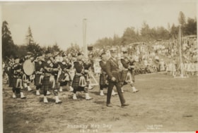
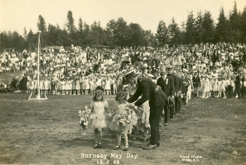
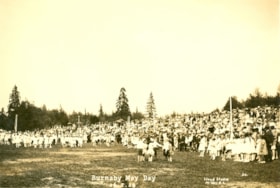
Burnaby May Day
https://search.heritageburnaby.ca/link/museumdescription39
- Repository
- Burnaby Village Museum
- Date
- May 26, 1928
- Collection/Fonds
- Burnaby Village Museum Photograph collection
- Description Level
- Item
- Physical Description
- 1 photograph : sepia ; 11 x 16.5 cm
- Scope and Content
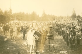
- Photograph of the procession of the bag pipe band at Burnaby May Day, at Robert Burnaby Park. Leading the pipe band is Constable George Jeffrey. A crowd and maypoles can be seen in the background.
- Repository
- Burnaby Village Museum
- Collection/Fonds
- Burnaby Village Museum Photograph collection
- Description Level
- Item
- Physical Description
- 1 photograph : sepia ; 11 x 16.5 cm
- Scope and Content
- Photograph of the procession of the bag pipe band at Burnaby May Day, at Robert Burnaby Park. Leading the pipe band is Constable George Jeffrey. A crowd and maypoles can be seen in the background.
- Names
- Jeffery, George
- Geographic Access
- Robert Burnaby Park
- Wedgewood Street
- Street Address
- 8155 Wedgewood Street
- Accession Code
- HV971.144.6
- Access Restriction
- No restrictions
- Reproduction Restriction
- No known restrictions
- Date
- May 26, 1928
- Media Type
- Photograph
- Historic Neighbourhood
- Burnaby Lake (Historic Neighbourhood)
- Planning Study Area
- Lakeview-Mayfield Area
- Related Material
- For another copy of this photograph in a different accession, see HV972.204.14
- Scan Resolution
- 600
- Scan Date
- 2023-03-28
- Photographer
- Lloyd, Frank Ernest
- Notes
- Title based on contents of photograph
- Inscribed on the negative and printed on the photograph, bottom front: "33 / Burnaby May Day 26. 5. 28 / Lloyd's Studio, McKay, B.C."
Images

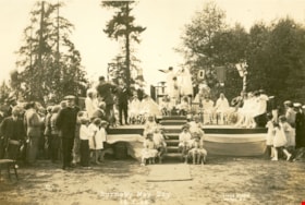
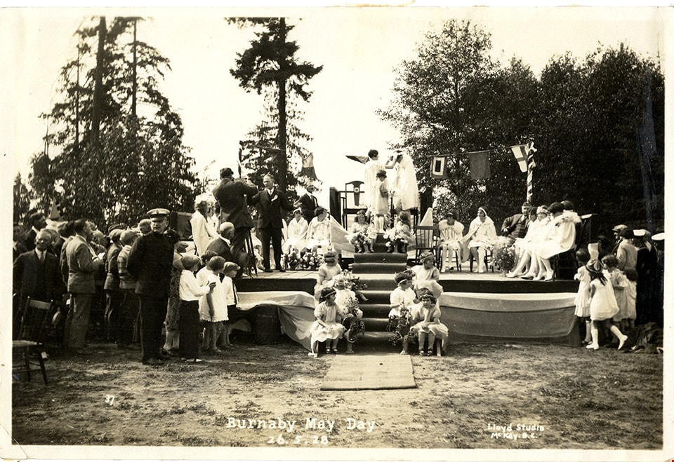
Burnaby May Day
https://search.heritageburnaby.ca/link/museumdescription3110
- Repository
- Burnaby Village Museum
- Date
- May 26, 1928
- Collection/Fonds
- Burnaby Village Museum Photograph collection
- Description Level
- Item
- Physical Description
- 1 photograph : sepia ; 11 x 16.5 cm
- Scope and Content
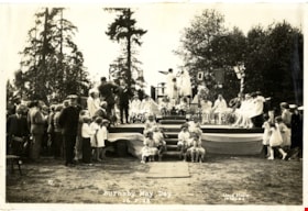
- Photograph of the coronation of the May Queen at Robert Burnaby Park. The May Queen and her suite are seated on chairs on a stage, with flower girls seated on the steps leading up to the stage. Men, women and children are gathered around the stage to watch the coronation.
- Repository
- Burnaby Village Museum
- Collection/Fonds
- Burnaby Village Museum Photograph collection
- Description Level
- Item
- Physical Description
- 1 photograph : sepia ; 11 x 16.5 cm
- Scope and Content
- Photograph of the coronation of the May Queen at Robert Burnaby Park. The May Queen and her suite are seated on chairs on a stage, with flower girls seated on the steps leading up to the stage. Men, women and children are gathered around the stage to watch the coronation.
- Geographic Access
- Robert Burnaby Park
- Wedgewood Street
- Street Address
- 8155 Wedgewood Street
- Accession Code
- HV972.204.4
- Access Restriction
- No restrictions
- Reproduction Restriction
- No known restrictions
- Date
- May 26, 1928
- Media Type
- Photograph
- Historic Neighbourhood
- Burnaby Lake (Historic Neighbourhood)
- Planning Study Area
- Lakeview-Mayfield Area
- Related Material
- For other photographs from the same album, see HV972.204.3 - .14
- Scan Resolution
- 600
- Scan Date
- 2023-04-25
- Photographer
- Lloyd, Frank Ernest
- Notes
- Title based on contents of photograph
- Inscribed on the negative and printed on recto of photograph: "37 / Burnaby May Day 26. 5. 28 / Lloyd Studio, McKay B.C."
- Stamped on verso of the photograph: "Lloyd's Studio / 3965 Kingsway / McKay, B.C. Carl. 343R2."
Images

Burnaby May Day
https://search.heritageburnaby.ca/link/museumdescription3111
- Repository
- Burnaby Village Museum
- Date
- May 26, 1928
- Collection/Fonds
- Burnaby Village Museum Photograph collection
- Description Level
- Item
- Physical Description
- 1 photograph : sepia ; 11 x 16.5 cm
- Scope and Content
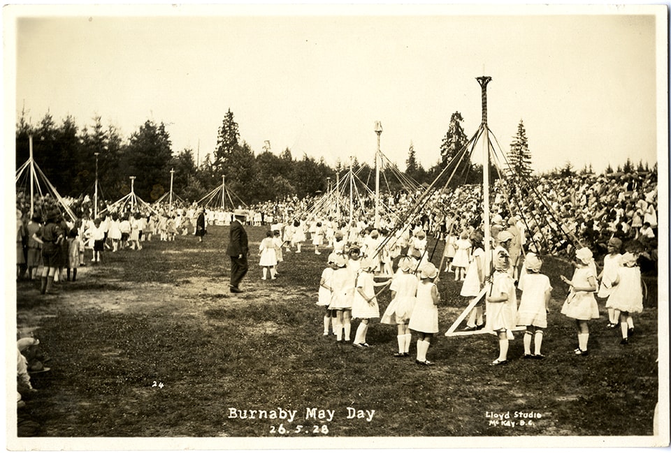
- Photograph of the May Queen and her suite in a procession at Burnaby May Day at Robert Burnaby Park. The flower girls are leading the procession, as people gather around on the field to watch (a Maypole can be seen in the centre of the photograph).
- Repository
- Burnaby Village Museum
- Collection/Fonds
- Burnaby Village Museum Photograph collection
- Description Level
- Item
- Physical Description
- 1 photograph : sepia ; 11 x 16.5 cm
- Scope and Content
- Photograph of the May Queen and her suite in a procession at Burnaby May Day at Robert Burnaby Park. The flower girls are leading the procession, as people gather around on the field to watch (a Maypole can be seen in the centre of the photograph).
- Subjects
- Events - May Day
- Events - Parades
- Geographic Access
- Robert Burnaby Park
- Wedgewood Street
- Street Address
- 8155 Wedgewood Street
- Accession Code
- HV972.204.5
- Access Restriction
- No restrictions
- Reproduction Restriction
- No known restrictions
- Date
- May 26, 1928
- Media Type
- Photograph
- Historic Neighbourhood
- Burnaby Lake (Historic Neighbourhood)
- Planning Study Area
- Lakeview-Mayfield Area
- Related Material
- For other photographs from the same album, see HV972.204.3 - .14
- Scan Resolution
- 600
- Scan Date
- 2023-04-25
- Photographer
- Lloyd, Frank Ernest
- Notes
- Title based on contents of photograph
- Inscribed on the negative and printed on the bottom front of the photograph: "27 / Burnaby May Day 26. 5. 28 / Lloyd Studio, McKay B.C."
Images

Burnaby May Day
https://search.heritageburnaby.ca/link/museumdescription3112
- Repository
- Burnaby Village Museum
- Date
- May 26, 1928
- Collection/Fonds
- Burnaby Village Museum Photograph collection
- Description Level
- Item
- Physical Description
- 1 photograph : sepia ; 11 x 16.5 cm
- Scope and Content
- Photograph of a procession led by flower girls at Burnaby May Day, at Robert Burnaby Park. A constable in uniform is standing next to one of the lead flower girls with his hands on her shoulders, directing her. People are gathered around on the field to watch the procession. A Maypole can be seen o…
- Repository
- Burnaby Village Museum
- Collection/Fonds
- Burnaby Village Museum Photograph collection
- Description Level
- Item
- Physical Description
- 1 photograph : sepia ; 11 x 16.5 cm
- Scope and Content
- Photograph of a procession led by flower girls at Burnaby May Day, at Robert Burnaby Park. A constable in uniform is standing next to one of the lead flower girls with his hands on her shoulders, directing her. People are gathered around on the field to watch the procession. A Maypole can be seen on the left.
- Geographic Access
- Robert Burnaby Park
- Wedgewood Street
- Street Address
- 8155 Wedgewood Street
- Accession Code
- HV972.204.6
- Access Restriction
- No restrictions
- Reproduction Restriction
- No known restrictions
- Date
- May 26, 1928
- Media Type
- Photograph
- Historic Neighbourhood
- Burnaby Lake (Historic Neighbourhood)
- Planning Study Area
- Lakeview-Mayfield Area
- Related Material
- For other photographs from the same album, see HV972.204.3 - .14
- Scan Resolution
- 600
- Scan Date
- 2023-04-25
- Photographer
- Lloyd, Frank Ernest
- Notes
- Inscribed in the negative and printed on the bottom front of the photograph: "Burnaby May Day 26. 5. 28 / Lloyd Studio, McKay, B.C. / 36."
Images
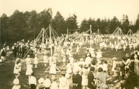
Burnaby May Day
https://search.heritageburnaby.ca/link/museumdescription3114
- Repository
- Burnaby Village Museum
- Date
- May 26, 1928
- Collection/Fonds
- Burnaby Village Museum Photograph collection
- Description Level
- Item
- Physical Description
- 1 photograph : sepia ; 11 x 16.5 cm
- Scope and Content
- Photograph of folk dancing groups celebrating Burnaby's May Day at Robert Burnaby Park. The dance groups are composed of young boys and girls. Some dance groups are gathered around Maypoles, and a crowd is on a hill by the field watching.
- Repository
- Burnaby Village Museum
- Collection/Fonds
- Burnaby Village Museum Photograph collection
- Description Level
- Item
- Physical Description
- 1 photograph : sepia ; 11 x 16.5 cm
- Scope and Content
- Photograph of folk dancing groups celebrating Burnaby's May Day at Robert Burnaby Park. The dance groups are composed of young boys and girls. Some dance groups are gathered around Maypoles, and a crowd is on a hill by the field watching.
- Geographic Access
- Wedgewood Street
- Robert Burnaby Park
- Street Address
- 8155 Wedgewood Street
- Accession Code
- HV972.204.8
- Access Restriction
- No restrictions
- Reproduction Restriction
- No known restrictions
- Date
- May 26, 1928
- Media Type
- Photograph
- Historic Neighbourhood
- Burnaby Lake (Historic Neighbourhood)
- Planning Study Area
- Lakeview-Mayfield Area
- Related Material
- For other photographs from the same album, see HV972.204.3 - .14
- Scan Resolution
- 600
- Scan Date
- 2023-04-25
- Photographer
- Lloyd, Frank Ernest
- Notes
- Title based on contents of photograph
- Inscribed on the negative and printed on the bottom front of the photograph: "Burnaby May Day 26. 5. 28 / Lloyd Studio, McKay B.C. / 20."
Images

Burnaby May Day
https://search.heritageburnaby.ca/link/museumdescription3115
- Repository
- Burnaby Village Museum
- Date
- May 26, 1928
- Collection/Fonds
- Burnaby Village Museum Photograph collection
- Description Level
- Item
- Physical Description
- 1 photograph : sepia ; 11 x 16.5 cm
- Scope and Content
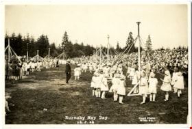
- Photograph of several maypoles that have been errected in celebration of Burnaby's May Day at Robert Burnaby Park. At every maypole, there are children (mainly girls), each holding a ribbon. The girls are wearing white dresses and some have white caps. A crowd is watching.
- Repository
- Burnaby Village Museum
- Collection/Fonds
- Burnaby Village Museum Photograph collection
- Description Level
- Item
- Physical Description
- 1 photograph : sepia ; 11 x 16.5 cm
- Scope and Content
- Photograph of several maypoles that have been errected in celebration of Burnaby's May Day at Robert Burnaby Park. At every maypole, there are children (mainly girls), each holding a ribbon. The girls are wearing white dresses and some have white caps. A crowd is watching.
- Geographic Access
- Wedgewood Street
- Robert Burnaby Park
- Street Address
- 8155 Wedgewood Street
- Accession Code
- HV972.204.9
- Access Restriction
- No restrictions
- Reproduction Restriction
- No known restrictions
- Date
- May 26, 1928
- Media Type
- Photograph
- Historic Neighbourhood
- Burnaby Lake (Historic Neighbourhood)
- Planning Study Area
- Lakeview-Mayfield Area
- Related Material
- For other photographs from the same album, see HV972.204.3 - .14
- Scan Resolution
- 600
- Scan Date
- 2023-04-25
- Photographer
- Lloyd, Frank Ernest
- Notes
- Title based on contents of photograph
- Inscribed on the negative and printed on the photograph, bottom front: "Burnaby May Day 26. 5. 28 / Lloyd Studio, McKay. B.C."
Images
Burnaby May Day
https://search.heritageburnaby.ca/link/museumdescription3118
- Repository
- Burnaby Village Museum
- Date
- May 26, 1928
- Collection/Fonds
- Burnaby Village Museum Photograph collection
- Description Level
- Item
- Physical Description
- 1 photograph : sepia ; 11 x 16.5 cm
- Scope and Content
- Photograph of the procession to the retiring Queen at Burnaby May Day, at Robert Burnaby Park. The retiring May Queen is escorted by a gentleman in suit holding his hat. There are boys in uniforms lined up along both sides of the procession, with a large crowd gathered behind them.
- Repository
- Burnaby Village Museum
- Collection/Fonds
- Burnaby Village Museum Photograph collection
- Description Level
- Item
- Physical Description
- 1 photograph : sepia ; 11 x 16.5 cm
- Scope and Content
- Photograph of the procession to the retiring Queen at Burnaby May Day, at Robert Burnaby Park. The retiring May Queen is escorted by a gentleman in suit holding his hat. There are boys in uniforms lined up along both sides of the procession, with a large crowd gathered behind them.
- Subjects
- Organizations - Boys' Societies and Clubs
- Persons - Crowds
- Events - May Day
- Clothing - Uniforms
- Names
- Boy Scouts of Canada
- Geographic Access
- Wedgewood Street
- Robert Burnaby Park
- Street Address
- 8155 Wedgewood Street
- Accession Code
- HV972.204.12
- Access Restriction
- No restrictions
- Reproduction Restriction
- No known restrictions
- Date
- May 26, 1928
- Media Type
- Photograph
- Historic Neighbourhood
- Burnaby Lake (Historic Neighbourhood)
- Planning Study Area
- Lakeview-Mayfield Area
- Related Material
- For other photographs from the same album, see HV972.204.3 - .14
- Scan Resolution
- 600
- Scan Date
- 2023-04-25
- Photographer
- Lloyd, Frank Ernest
- Notes
- Inscribed on the negative and printed on the photograph reads: "34 / Burnaby May Day / 26. 5. 28 / Lloyd Studio, McKay B.C."
Images

Burnaby May Day
https://search.heritageburnaby.ca/link/museumdescription4882
- Repository
- Burnaby Village Museum
- Date
- May 26, 1928
- Collection/Fonds
- Burnaby Girl Guides fonds
- Description Level
- Item
- Physical Description
- 1 photograph : sepia ;11.5 x 17 cm
- Scope and Content
- Photograph of Burnaby May Day held in Robert Burnaby Park. Children are wearing white dresses and gathered around several may poles set up on a large field during the Burnaby May Day celebrations. The May pole on the left side of the photograph is surrounded by young girls in Girl Guide uniforms. A…
- Repository
- Burnaby Village Museum
- Collection/Fonds
- Burnaby Girl Guides fonds
- Description Level
- Item
- Physical Description
- 1 photograph : sepia ;11.5 x 17 cm
- Scope and Content
- Photograph of Burnaby May Day held in Robert Burnaby Park. Children are wearing white dresses and gathered around several may poles set up on a large field during the Burnaby May Day celebrations. The May pole on the left side of the photograph is surrounded by young girls in Girl Guide uniforms. A large crowd is gathered and is looking on.
- Subjects
- Events - May Day
- Names
- Girl Guides of Canada
- Geographic Access
- Robert Burnaby Park
- Accession Code
- BV015.35.240
- Access Restriction
- No restrictions
- Reproduction Restriction
- No known restrictions
- Date
- May 26, 1928
- Media Type
- Photograph
- Historic Neighbourhood
- Burnaby Lake (Historic Neighbourhood)
- Planning Study Area
- Lakeview-Mayfield Area
- Scan Resolution
- 600
- Scan Date
- January 4, 2021
- Scale
- 100
- Photographer
- Lloyd, Frank Ernest
- Notes
- Title based on content of photograph
- Type script in white on bottom of photograph reads: "Burnaby May Day / 26. 5.28 / Lloyd Studio / McKay B.C."
- Stamp in black ink on verso of photograph reads: "Lloyd's Studio / 3966 Kingsway / McKay, B.C. Calr. 343R2"
- Photograph is a part of scrapbook (page 25) "Burnaby Girl Guides. -- [1914]-1969, predominant ca. 1920" (BV.015.35.164)
Images
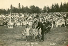
Burnaby May Day ceremony
https://search.heritageburnaby.ca/link/museumdescription4883
- Repository
- Burnaby Village Museum
- Date
- May 26, 1928
- Collection/Fonds
- Burnaby Girl Guides fonds
- Description Level
- Item
- Physical Description
- 1 photograph : sepia ;11.5 x 17 cm
- Scope and Content
- Photograph of the crowning of May Queen Sylvia Murley (later Sylvia Auvache) at Robert Burnaby Park. The May Queen and her suite are seated on chairs on a stage, with flower girls seated on the steps leading up to the stage. Men, women and children are gathered around the stage to watch the crownin…
- Repository
- Burnaby Village Museum
- Collection/Fonds
- Burnaby Girl Guides fonds
- Description Level
- Item
- Physical Description
- 1 photograph : sepia ;11.5 x 17 cm
- Scope and Content
- Photograph of the crowning of May Queen Sylvia Murley (later Sylvia Auvache) at Robert Burnaby Park. The May Queen and her suite are seated on chairs on a stage, with flower girls seated on the steps leading up to the stage. Men, women and children are gathered around the stage to watch the crowning of the May Queen.
- Subjects
- Events - May Day
- Geographic Access
- Robert Burnaby Park
- Accession Code
- BV015.35.241
- Access Restriction
- No restrictions
- Reproduction Restriction
- No known restrictions
- Date
- May 26, 1928
- Media Type
- Photograph
- Historic Neighbourhood
- Burnaby Lake (Historic Neighbourhood)
- Planning Study Area
- Lakeview-Mayfield Area
- Related Material
- See also photograph HV972.204.4
- Scan Resolution
- 600
- Scan Date
- January 4, 2021
- Scale
- 100
- Notes
- Title based on content of photograph
- Type script in white on bottom of photograph reads: "Burnaby May Day / 26. 5.28 / Lloyd Studio / McKay B.C."
- Stamp in black ink on verso of photograph reads: "Lloyd's Studio / 3966 Kingsway / McKay, B.C. Calr. 343R2"
- Photograph is a part of scrapbook (page 26) "Burnaby Girl Guides. -- [1914]-1969, predominant ca. 1920" (BV.015.35.164)
Images
![Deer Lake, [1914] thumbnail](/media/hpo/_Data/_BVM_Images/1971/197200110018.jpg?width=280)
Deer Lake
https://search.heritageburnaby.ca/link/museumdescription3104
- Repository
- Burnaby Village Museum
- Date
- [1914]
- Collection/Fonds
- Burnaby Village Museum Photograph collection
- Description Level
- Item
- Physical Description
- 1 photograph : b&w glass negative ; 16.4 x 21.2 cm
- Scope and Content
- Photograph of the north shore of Deer Lake as seen from the south shore. According to an earlier 1988 catalogue record, in view from left to right are: H.T. Ceperley's "Fairacres," The Mathers "Altnadene," and the Anderson house on the hill. On shoreline are the Hart's boathouse and beach cottage…
- Repository
- Burnaby Village Museum
- Collection/Fonds
- Burnaby Village Museum Photograph collection
- Description Level
- Item
- Physical Description
- 1 photograph : b&w glass negative ; 16.4 x 21.2 cm
- Scope and Content
- Photograph of the north shore of Deer Lake as seen from the south shore. According to an earlier 1988 catalogue record, in view from left to right are: H.T. Ceperley's "Fairacres," The Mathers "Altnadene," and the Anderson house on the hill. On shoreline are the Hart's boathouse and beach cottage and the Woodward's boathouse.
- Geographic Access
- Deer Lake Avenue
- Street Address
- 6490 Deer Lake Avenue
- 6344 Deer Lake Avenue
- Accession Code
- HV972.11.18
- Access Restriction
- No restrictions
- Reproduction Restriction
- No known restrictions
- Date
- [1914]
- Media Type
- Photograph
- Historic Neighbourhood
- Burnaby Lake (Historic Neighbourhood)
- Planning Study Area
- Lakeview-Mayfield Area
- Related Material
- For other shots of the Deer Lake in the same accession, see HV972.11.6 and HV972.11.16
- Scan Resolution
- 300
- Scan Date
- 14/8/2006
- Scale
- 100
- Notes
- Title based on contents of photograph
- 1 b&w contact print accompanying negative
Images
![Deer Lake, [1914] thumbnail](/media/hpo/_Data/_BVM_Images/1971/197200110018.jpg)
![Douglas Road, [1897] (date of original), copied 1978 thumbnail](/media/hpo/_Data/_BVM_Images/1978/1978_0001_0001_001.jpg?width=280)
Douglas Road
https://search.heritageburnaby.ca/link/museumdescription447
- Repository
- Burnaby Village Museum
- Date
- [1897] (date of original), copied 1978
- Collection/Fonds
- Burnaby Village Museum Photograph collection
- Description Level
- Item
- Physical Description
- 1 photograph : b&w ; 20.2 x 25.2 cm print
- Scope and Content
- Photograph of Douglas Road (later renamed in part Canada Way), near Stanley Street. To the right is the Sprott family property, where a few wooden buildings are visible in the cleared area. Charles Sprott, head of the Sprott family, was an important Burnaby politician who was continuously elected t…
- Repository
- Burnaby Village Museum
- Collection/Fonds
- Burnaby Village Museum Photograph collection
- Description Level
- Item
- Physical Description
- 1 photograph : b&w ; 20.2 x 25.2 cm print
- Scope and Content
- Photograph of Douglas Road (later renamed in part Canada Way), near Stanley Street. To the right is the Sprott family property, where a few wooden buildings are visible in the cleared area. Charles Sprott, head of the Sprott family, was an important Burnaby politician who was continuously elected to serve in the municiality as councillor from 1895 to 1903 and as Reeve from 1904 to 1905.
- Subjects
- Geographic Features - Roads
- Land Clearing
- Geographic Access
- Douglas Road
- Canada Way
- Stanley Street
- Accession Code
- HV978.1.1
- Access Restriction
- No restrictions
- Reproduction Restriction
- No known restrictions
- Date
- [1897] (date of original), copied 1978
- Media Type
- Photograph
- Historic Neighbourhood
- Burnaby Lake (Historic Neighbourhood)
- Planning Study Area
- Lakeview-Mayfield Area
- Scan Resolution
- 600
- Scan Date
- 2023-07-25
- Notes
- Title based on contents of photograph
Images
![Douglas Road, [1897] (date of original), copied 1978 thumbnail](/media/hpo/_Data/_BVM_Images/1978/1978_0001_0001_001.jpg)
![Fraser Valley Nurseries, [191-?] (date of original), copied 1977 thumbnail](/media/hpo/_Data/_BVM_Images/1977/1977_0099_0017_001.jpg?width=280)
Fraser Valley Nurseries
https://search.heritageburnaby.ca/link/museumdescription575
- Repository
- Burnaby Village Museum
- Date
- [191-?] (date of original), copied 1977
- Collection/Fonds
- Burnaby Village Museum Photograph collection
- Description Level
- Item
- Physical Description
- 1 photograph : b&w ; 20.32 x 25.4 cm
- Scope and Content
- Photograph of the grounds of the Fraser Valley Nurseries. The grounds are fenced with wire and wooden posts.There is a large sign on the left of the photograph that reads "The Fraser Valley Nurseries, Ltd." There are a few barns or sheds on the nursery grounds. Behind the nursery can be seen a la…
- Repository
- Burnaby Village Museum
- Collection/Fonds
- Burnaby Village Museum Photograph collection
- Description Level
- Item
- Physical Description
- 1 photograph : b&w ; 20.32 x 25.4 cm
- Scope and Content
- Photograph of the grounds of the Fraser Valley Nurseries. The grounds are fenced with wire and wooden posts.There is a large sign on the left of the photograph that reads "The Fraser Valley Nurseries, Ltd." There are a few barns or sheds on the nursery grounds. Behind the nursery can be seen a large body of water, most likely Burnaby Lake. The accession register and the inscription on the photograph identify the location as just off Douglas Road (now Canada Way). The annotation on the back of the photograph reads: "Located off Canada Way."
- Subjects
- Agriculture - Farms
- Names
- Fraser Valley Nurseries
- Geographic Access
- Douglas Road
- Canada Way
- Nursery Street
- Burnaby Lake
- Accession Code
- HV977.99.17
- Access Restriction
- No restrictions
- Reproduction Restriction
- May be restricted by third party rights
- Date
- [191-?] (date of original), copied 1977
- Media Type
- Photograph
- Historic Neighbourhood
- Burnaby Lake (Historic Neighbourhood)
- Planning Study Area
- Lakeview-Mayfield Area
- Related Material
- For the right side of the two part panorama of the nurseries, see HV977.99.19
- Scan Resolution
- 600
- Scan Date
- 2023-07-11
- Notes
- Title based on contents of photograph
Images
![Fraser Valley Nurseries, [191-?] (date of original), copied 1977 thumbnail](/media/hpo/_Data/_BVM_Images/1977/1977_0099_0017_001.jpg)
![Fraser Valley Nurseries, [191-?] (date of original), copied 1977 thumbnail](/media/hpo/_Data/_BVM_Images/1977/1977_0099_0019_001.jpg?width=280)
Fraser Valley Nurseries
https://search.heritageburnaby.ca/link/museumdescription577
- Repository
- Burnaby Village Museum
- Date
- [191-?] (date of original), copied 1977
- Collection/Fonds
- Burnaby Village Museum Photograph collection
- Description Level
- Item
- Physical Description
- 1 photograph : b&w ; 20.2 x 25.2 cm print
- Scope and Content
- Photograph of the grounds of the Fraser Valley Nurseries. The grounds are fenced with wire and wooden posts. There are a few barns or sheds on the nursery grounds. Behind the nursery can be seen a large body of water, most likely Burnaby Lake. The accession register identifies the location as j…
- Repository
- Burnaby Village Museum
- Collection/Fonds
- Burnaby Village Museum Photograph collection
- Description Level
- Item
- Physical Description
- 1 photograph : b&w ; 20.2 x 25.2 cm print
- Scope and Content
- Photograph of the grounds of the Fraser Valley Nurseries. The grounds are fenced with wire and wooden posts. There are a few barns or sheds on the nursery grounds. Behind the nursery can be seen a large body of water, most likely Burnaby Lake. The accession register identifies the location as just off Douglas Road (now Canada Way). An annotation on the back of the photo reads: "View Fraser Valley Nurseries."
- Subjects
- Agriculture - Farms
- Names
- Fraser Valley Nurseries
- Geographic Access
- Douglas Road
- Canada Way
- Nursery Street
- Burnaby Lake
- Accession Code
- HV977.99.19
- Access Restriction
- No restrictions
- Reproduction Restriction
- May be restricted by third party rights
- Date
- [191-?] (date of original), copied 1977
- Media Type
- Photograph
- Historic Neighbourhood
- Burnaby Lake (Historic Neighbourhood)
- Planning Study Area
- Lakeview-Mayfield Area
- Related Material
- For the left side of the two part panorama of the nurseries, see HV977.99.17
- Scan Resolution
- 600
- Scan Date
- 2023-07-11
- Notes
- Title based on contents of photograph
Images
![Fraser Valley Nurseries, [191-?] (date of original), copied 1977 thumbnail](/media/hpo/_Data/_BVM_Images/1977/1977_0099_0019_001.jpg)