Narrow Results By
Decade
- 2020s 66
- 2010s 99
- 2000s 95
- 1990s 207
- 1980s 151
- 1970s 220
- 1960s 169
- 1950s 204
- 1940s 214
- 1930s 180
- 1920s 127
- 1910s 124
- 1900s 68
- 1890s 27
- 1880s 12
- 1870s 3
- 1860s 2
- 1850s 2
- 1840s 1
- 1830s 1
- 1820s 1
- 1810s 1
- 1800s 1
- 1790s 1
- 1780s 1
- 1770s 1
- 1760s 1
- 1750s 1
- 1740s 1
- 1730s 1
- 1720s 1
- 1710s 1
- 1700s 1
- 1690s 1
- 1680s 1
- 1670s 1
- 1660s 1
- 1650s 1
- 1640s 1
- 1630s 1
- 1620s 1
- 1610s 1
- 1600s 1

Interview with W.H. O'Brien July / August 1975 - Track 8
https://search.heritageburnaby.ca/link/oralhistory25
- Repository
- City of Burnaby Archives
- Date Range
- [1932]-1936
- Length
- 0:11:12
- Summary
- This portion of the interview pertains to W.H. "Harry" O'Brien's involvement with the formation of the Army of the Common Good Credit Union (now the South Burnaby Credit Union).
- Repository
- City of Burnaby Archives
- Summary
- This portion of the interview pertains to W.H. "Harry" O'Brien's involvement with the formation of the Army of the Common Good Credit Union (now the South Burnaby Credit Union).
- Date Range
- [1932]-1936
- Photo Info
- Harry and Gertrude (Sutherland) O'Brien on their wedding day, October 12, 1940. Item no. 315-005
- Length
- 0:11:12
- Subjects
- Organizations
- Interviewer
- Bradbury, Dr. Bettina
- Interview Date
- July / August 1975
- Scope and Content
- Recording is a taped interview with W.H. "Harry" O'Brien by SFU (Simon Fraser University) graduate student Bettina Bradbury. Major themes discussed are: the Army of the Common Good, the Union of the Unemployed and the Common Good Credit Union (now the South Burnaby Credit Union). To view "Narrow By" terms for each track expand this description and see "Notes".
- Biographical Notes
- W.H. “Harry” O’Brien was born in the coal mining town of Nanaimo, British Columbia on October 20, 1914. He came to Burnaby with his parents and five siblings in 1927. Harry’s mother, a school teacher, wanted her children to live closer to school in order to obtain a better education, so the O’Brien family settled at Inman Avenue, Burnaby. Harry's mother, Mary Anne Crossan, was Gilmore Avenue School's first teacher. Harry left school in June of 1929. Harry’s father worked as the caretaker at Central Park around this time and Harry helped him to clear brush, plant trees and enforce the land clearing and wood cutting permit regulations held by men who were on script. Although too young to vote by just over a week, Harry O'Brien worked as a scrutineer for the Co-operative Commonwealth Federation (CCF) during the 1935 Federal Election. On October 12, 1940 Harry O'Brien married Gertrude Sutherland at St. John the Divine in Burnaby. The Sutherland family came to Burnaby from Winnipeg in 1933 and settled at Nelson Avenue. Harry began his involvement with the Unemployment Organization in Burnaby by participating in an organised protest against the municipality for homeowner evictions brought on by unpaid taxes. The South Burnaby Union of the Unemployed organised in order to protest rules around receiving Relief. Harry became involved, eventually becoming one of the spearheads of the organization, taking over as secretary by 1936. Harry was an original member of the Army of the Common Good, helping to produce over one hundred and twenty-five tons of vegetables from its own gardens to feed Burnaby citizens suffering from the lack of resources during the Depression years. The members of the Army of the Common Good who cut wood for consumption or worked in the gardens were given credit for their work through LU (Labour Units) which they could then use to buy groceries and that at the Army's Cooperative stores, one of which was at McKay Avenue, where Harry began working as Manager of Groceries in 1937. The Credit Union movement of British Columbia was also organized by Harry O'Brien and his fellow Army of the Common Good members. W.H. "Harry" O'Brien died July 1, 1992.
- Total Tracks
- 9
- Total Length
- 1:17:56
- Interviewee Name
- O'Brien, Harry
- Interviewer Bio
- Bettina Bradbury teaches history and women's studies at York University. She is the author of Wife to Widow. Lives, Laws and Politics in Nineteenth-century Montreal. (Vancouver: University of British Columbia Press, June 2011), 520p; Working Families. Age, Gender and Daily Survival in Industrializing Montreal. (Toronto: Canadian Social History Series, McClelland and Stewart, 1993); (Republished Toronto: Oxford University Press, 1996) (3rd edition, Toronto: University of Toronto Press, 2007). These interviews were undertaken after she completed her MA at Simon Fraser University in 1975 with the support of an LIP grant.
- Collection/Fonds
- Burnaby Historical Society fonds
- Subseries
- Oral history subseries
- Transcript Available
- None
- Media Type
- Sound Recording
- Web Notes
- Interview was digitized in 2010 allowing it to be accessible on Heritage Burnaby. The digitization project was initiated by the Community Heritage Commission with support from City of Burnaby Council and the BC History Digitization Program of the Irving K. Barber Learning Centre, University of British Columbia. It was recognized by the Heritage Society of BC with an award in 2012.
Images

Audio Tracks
Track eight of interview with W.H.
Track eight of interview with W.H.
https://search.heritageburnaby.ca/media/hpo/_Data/_Archives_Oral_Histories/_Unrestricted/100-13-25/100-13-25_Track_8.mp3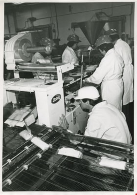
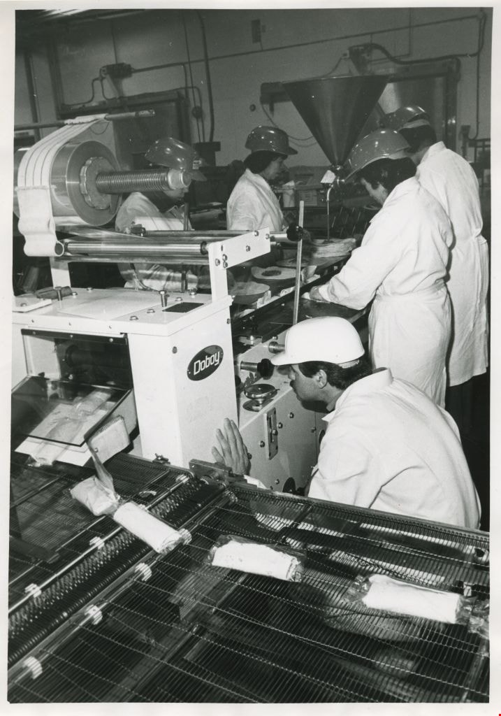
Rosita's Burritos - People working
https://search.heritageburnaby.ca/link/archivedescription58903
- Repository
- City of Burnaby Archives
- Date
- ca.1980
- Collection/Fonds
- Columbian Newspaper collection
- Description Level
- Item
- Physical Description
- 1 photograph : b&w ; 25 x 18 cm
- Scope and Content
- Photograph of factory workers on the line at Rosita's Burritos. Plastic-wrapped burritos are coming out of the machine. The photograph is from Burnaby Today.
- Repository
- City of Burnaby Archives
- Date
- ca.1980
- Collection/Fonds
- Columbian Newspaper collection
- Physical Description
- 1 photograph : b&w ; 25 x 18 cm
- Description Level
- Item
- Record No.
- 480-1360
- Access Restriction
- No restrictions
- Reproduction Restriction
- May be restricted by third party rights
- Accession Number
- 2009-01
- Scope and Content
- Photograph of factory workers on the line at Rosita's Burritos. Plastic-wrapped burritos are coming out of the machine. The photograph is from Burnaby Today.
- Subjects
- Buildings - Industrial - Factories
- Media Type
- Photograph
- Photographer
- King, Basil
- Notes
- Title based on contents of photograph
- Photographer's stamp on verso
- Note on verso reads: "Burnaby Today / page A4 / 85%"
Images
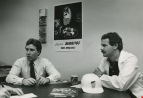
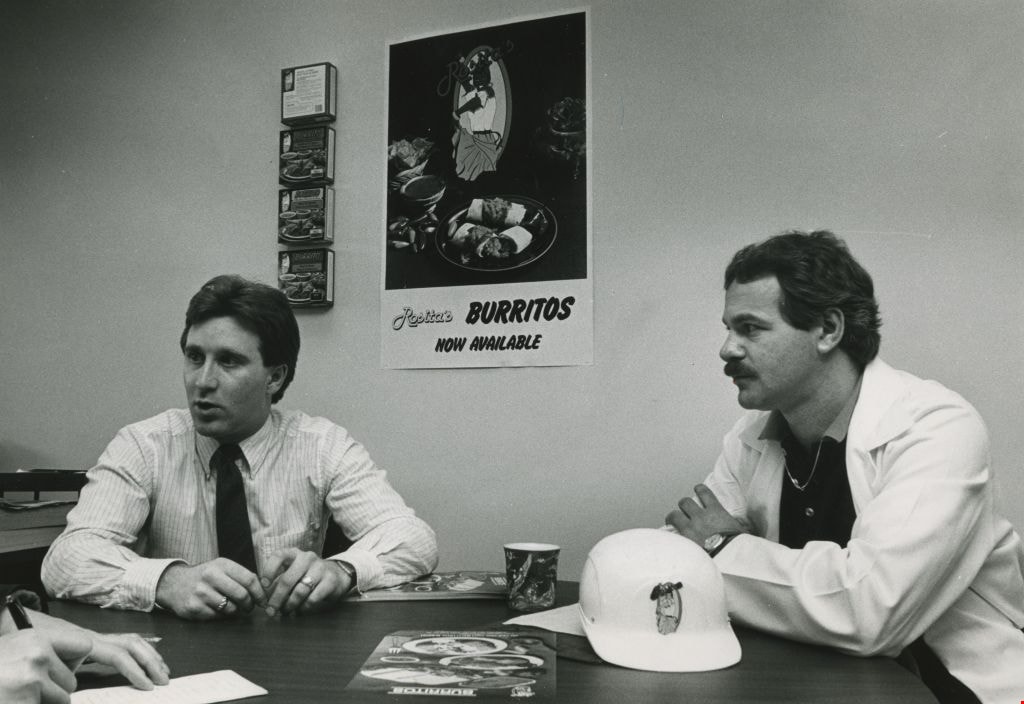
Rosita's Burritos
https://search.heritageburnaby.ca/link/archivedescription58905
- Repository
- City of Burnaby Archives
- Date
- ca.1980
- Collection/Fonds
- Columbian Newspaper collection
- Description Level
- Item
- Physical Description
- 1 photograph : b&w ; 17.5 x 25 cm
- Scope and Content
- Photograph of two unidentified men, sitting at a table underneath a "Rosita's Burritos Now Available" sign. The photograph is from Burnaby Today.
- Repository
- City of Burnaby Archives
- Date
- ca.1980
- Collection/Fonds
- Columbian Newspaper collection
- Physical Description
- 1 photograph : b&w ; 17.5 x 25 cm
- Description Level
- Item
- Record No.
- 480-1361
- Access Restriction
- No restrictions
- Reproduction Restriction
- May be restricted by third party rights
- Accession Number
- 2009-01
- Scope and Content
- Photograph of two unidentified men, sitting at a table underneath a "Rosita's Burritos Now Available" sign. The photograph is from Burnaby Today.
- Subjects
- Buildings - Industrial - Factories
- Media Type
- Photograph
- Photographer
- King, Basil
- Notes
- Title based on contents of photograph
- Photographer's stamp on verso
- Note on verso reads: "Burnaby Today page A4 / 62%"
Images
Adult Magazines
https://search.heritageburnaby.ca/link/archivedescription58940
- Repository
- City of Burnaby Archives
- Date
- ca.1983
- Collection/Fonds
- Columbian Newspaper collection
- Description Level
- Item
- Physical Description
- 1 photograph : b&w ; 14.5 x 25.5 cm
- Scope and Content
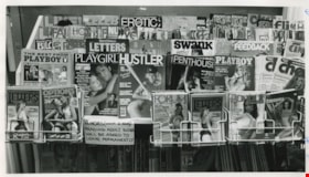
- Photograph of a display of adult magazines in a magazine rack. A handwritten sign reads: "Minors (under 18 years) reading adult books will be asked to leave permanently."
- Repository
- City of Burnaby Archives
- Date
- ca.1983
- Collection/Fonds
- Columbian Newspaper collection
- Physical Description
- 1 photograph : b&w ; 14.5 x 25.5 cm
- Description Level
- Item
- Record No.
- 480-1388
- Access Restriction
- No restrictions
- Reproduction Restriction
- May be restricted by third party rights
- Accession Number
- 2009-01
- Scope and Content
- Photograph of a display of adult magazines in a magazine rack. A handwritten sign reads: "Minors (under 18 years) reading adult books will be asked to leave permanently."
- Subjects
- Industries - Publishing
- Media Type
- Photograph
- Notes
- Title based on contents of photograph
- Note on verso reads: "COQ Today"
Images

Man sailing around Barnet Inlet
https://search.heritageburnaby.ca/link/archivedescription58997
- Repository
- City of Burnaby Archives
- Date
- ca.1983
- Collection/Fonds
- Columbian Newspaper collection
- Description Level
- Item
- Physical Description
- 1 photograph : b&w ; 18.5 x 25.5 cm
- Scope and Content
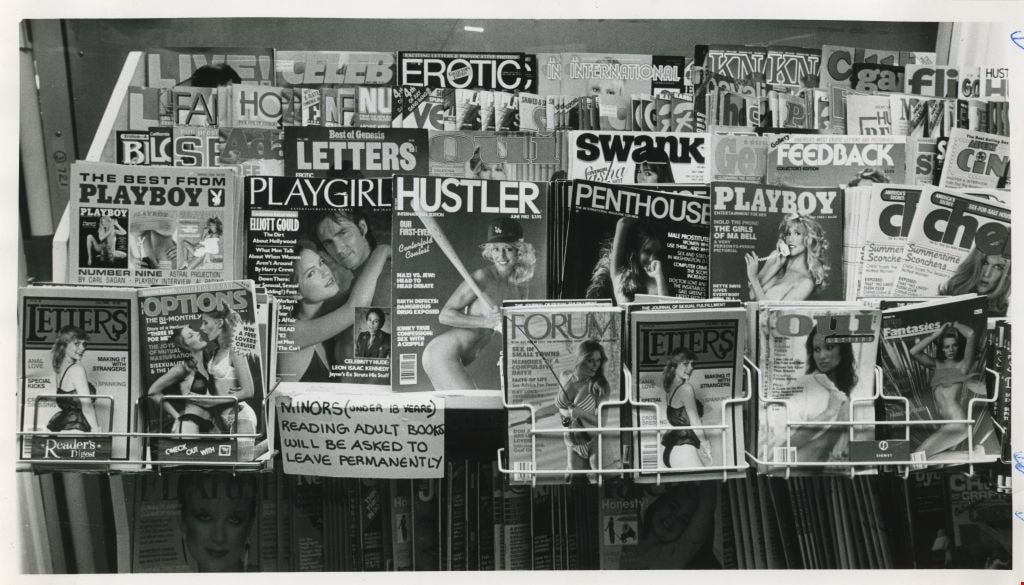
- Photograph of a sailboat sailing in the Burrard Inlet, by Barnet Park. The hills and oil refinery are visible in the background.
- Repository
- City of Burnaby Archives
- Date
- ca.1983
- Collection/Fonds
- Columbian Newspaper collection
- Physical Description
- 1 photograph : b&w ; 18.5 x 25.5 cm
- Description Level
- Item
- Record No.
- 480-1407
- Access Restriction
- No restrictions
- Reproduction Restriction
- May be restricted by third party rights
- Accession Number
- 2009-01
- Scope and Content
- Photograph of a sailboat sailing in the Burrard Inlet, by Barnet Park. The hills and oil refinery are visible in the background.
- Media Type
- Photograph
- Photographer
- Hodge, Craig
- Notes
- Title based on contents of photograph
- Photographer's stamp on verso
- Note on verso reads: "PMT 75% / page 4 / Burnaby Today"
- Geographic Access
- Burrard Inlet
- Barnet Marine Park
- Historic Neighbourhood
- Barnet (Historic Neighbourhood)
- Planning Study Area
- Burnaby Mountain Area
Images

Man chopping wood
https://search.heritageburnaby.ca/link/archivedescription59009
- Repository
- City of Burnaby Archives
- Date
- ca.1983
- Collection/Fonds
- Columbian Newspaper collection
- Description Level
- Item
- Physical Description
- 1 photograph : b&w ; 20.5 x 25.5 cm
- Scope and Content
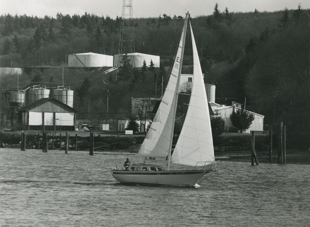
- Photograph of an unidentified man chopping through a standing log with an axe. Two other men look on in the background.
- Repository
- City of Burnaby Archives
- Date
- ca.1983
- Collection/Fonds
- Columbian Newspaper collection
- Physical Description
- 1 photograph : b&w ; 20.5 x 25.5 cm
- Description Level
- Item
- Record No.
- 480-1418
- Access Restriction
- No restrictions
- Reproduction Restriction
- May be restricted by third party rights
- Accession Number
- 2009-01
- Scope and Content
- Photograph of an unidentified man chopping through a standing log with an axe. Two other men look on in the background.
- Media Type
- Photograph
- Photographer
- King, Basil
- Notes
- Title based on contents of photograph
- Photographer's stamp on verso
- Note on verso reads: "PMT 80% / page A-5 / Burnaby / Today"
Images

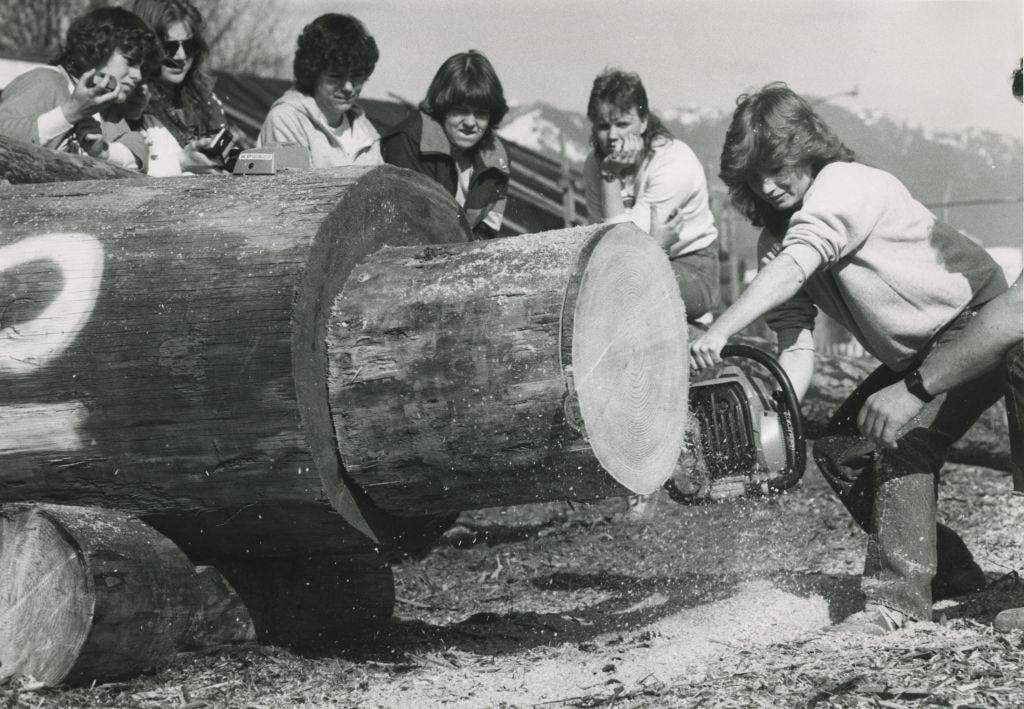
Maureen Demson cutting wood with a chainsaw
https://search.heritageburnaby.ca/link/archivedescription59010
- Repository
- City of Burnaby Archives
- Date
- ca.1983
- Collection/Fonds
- Columbian Newspaper collection
- Description Level
- Item
- Physical Description
- 1 photograph : b&w ; 20.5 x 25 cm
- Scope and Content
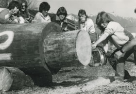
- Photograph of a woman identified as Maureen Demson. She is cutting a log with a chainsaw while other people watch.
- Repository
- City of Burnaby Archives
- Date
- ca.1983
- Collection/Fonds
- Columbian Newspaper collection
- Physical Description
- 1 photograph : b&w ; 20.5 x 25 cm
- Description Level
- Item
- Record No.
- 480-1419
- Access Restriction
- No restrictions
- Reproduction Restriction
- May be restricted by third party rights
- Accession Number
- 2009-01
- Scope and Content
- Photograph of a woman identified as Maureen Demson. She is cutting a log with a chainsaw while other people watch.
- Media Type
- Photograph
- Photographer
- King, Basil
- Notes
- Title based on contents of photograph
- Note on recto reads: "Maureen Demson"
- Photographer's stamp on verso
- Note on verso reads: "PMT 80% / page A-5 / Burnaby / Today"
Images
Bylaw Number: 4656 - Town Planning Bylaw 1948, Amendment No 17, 1964
https://search.heritageburnaby.ca/link/bylaw19713
- Repository
- Legislative Services
- Bylaw Number
- 4656
- Format
- Bylaws - Repealed
- Collection/Fonds
- City Council and Office of the City Clerk fonds
- Repository
- Legislative Services
- Bylaw Number
- 4656
- Format
- Bylaws - Repealed
- Collection/Fonds
- City Council and Office of the City Clerk fonds
Documents
Bylaw Number: 4390 - Town Planning Bylaw 1948, Amendment Bylaw No 14, 1962
https://search.heritageburnaby.ca/link/bylaw19978
- Repository
- Legislative Services
- Bylaw Number
- 4390
- Format
- Bylaws - Repealed
- Collection/Fonds
- City Council and Office of the City Clerk fonds
- Repository
- Legislative Services
- Bylaw Number
- 4390
- Format
- Bylaws - Repealed
- Collection/Fonds
- City Council and Office of the City Clerk fonds
Documents

Mortimer-Lamb House
https://search.heritageburnaby.ca/link/landmark494
- Repository
- Burnaby Heritage Planning
- Description
- The Mortimer-Lamb House is a one and one half-storey, Arts and Crafts-style residence with a steeply pitched, side-gabled roof. The original cottage form has been enlarged with a later addition on the west side of the house. Located next to the Burnaby Lake Regional Park Wildlife Rescue Care Centre…
- Associated Dates
- c.1922
- Formal Recognition
- Community Heritage Register
- Other Names
- Harold & Katherine Mortimer-Lamb Residence
- Street View URL
- Google Maps Street View
- Repository
- Burnaby Heritage Planning
- Other Names
- Harold & Katherine Mortimer-Lamb Residence
- Geographic Access
- Glencarin Drive
- Associated Dates
- c.1922
- Formal Recognition
- Community Heritage Register
- Enactment Type
- Council Resolution
- Enactment Date
- 26/05/2003
- Description
- The Mortimer-Lamb House is a one and one half-storey, Arts and Crafts-style residence with a steeply pitched, side-gabled roof. The original cottage form has been enlarged with a later addition on the west side of the house. Located next to the Burnaby Lake Regional Park Wildlife Rescue Care Centre, the house has picturesque views of Burnaby Lake.
- Heritage Value
- Built circa 1922, the Mortimer-Lamb House is valued for its association with first owners, Harold Mortimer-Lamb (1872-1970), and his wife, Katherine Mary Mortimer-Lamb (1873-1939). Born in Leatherhead, Surrey, England, Harold Mortimer-Lamb immigrated to Canada in 1889. Seven years later in Vancouver, he married Katherine Mary Lindsay, a native of Winnipeg. Mortimer-Lamb was a key figure in the B.C. mining industry, serving as Secretary of the Mining Association of B.C. between 1900 and 1945, and also as the Secretary of the Canadian Institute of Mining and Metallurgy. In addition to his professional life, Mortimer-Lamb was a pioneer art photographer and was among Canada's leading art critics, and this house served as a central gathering place for renowned Canadian artists of the day. Mortimer-Lamb’s daughter, Molly Lamb Bobak (born 1922), became a renowned watercolourist, and was the only woman ever hired as an official Canadian war artist. The Mortimer-Lamb House is a significant example of the work of noted architect, Samuel Maclure (1860-1929) and his partner, Ross Lort (1889-1969). Maclure, who was a close friend of the Mortimer-Lamb family, was British Columbia's leading residential architect, and was renowned for his high quality designs for prominent citizens in both Vancouver and Victoria. Maclure was a leading exponent of the Art and Crafts design movement in B.C., and established a sophisticated local variation of residential architecture. The Mortimer-Lamb House was designed at the time when Maclure was in partnership with Ross Lort. In 1907, Lort began working for Maclure's firm as a draftsman, and by 1920 was in charge of Maclure's Vancouver office. Lort's architectural career spanned some sixty-years, and he designed some of the province's most familiar houses, apartments, institutions and places of worship. The Mortimer-Lamb House is also a significant local example of the Arts and Crafts style, and incorporates elements such as board-and-batten siding on the ground floor, shingled gables and leaded casement windows. It is a testament to the domestic architecture built outside of established suburbs during the post-First World War era, typically modest in scale and representative of middle-class residential ideals.
- Defining Elements
- Key elements that define the heritage character of the Mortimer-Lamb House include its: - treed setting with views of Burnaby Lake - residential form, scale and massing as expressed by its one and one-half storey height, rectangular plan and steeply pitched side-gabled roof - wood-frame construction - Arts and Crafts elements such as board-and-batten siding on the ground floor, cedar shingles in the gables and open soffits - original straight-leaded casement windows in single and multiple-assembly - internal red-brick chimney with corbelled cap
- Historic Neighbourhood
- Burnaby Lake (Historic Neighbourhood)
- Planning Study Area
- Burnaby Lake Area
- Organization
- Mining Association of B.C.
- G.F. and J. Galt Limited
- Architect
- Samuel Maclure
- Ross Lort
- Function
- Primary Historic--Single Dwelling
- Primary Current--Single Dwelling
- Community
- Burnaby Lake
- Cadastral Identifier
- P.I.D.002-977-788
- Boundaries
- The Mortimer-Lamb House is comprised of a single residential lot located at 5180 Glencairn Drive, Burnaby.
- Area
- 5652.78
- Contributing Resource
- Building
- Ownership
- Private
- Documentation
- City of Burnaby Planning and Building Department, Heritage Site Files
- Street Address
- 5180 Glencarin Drive
- Street View URL
- Google Maps Street View
Images


Broadview Neighbourhood
https://search.heritageburnaby.ca/link/landmark687
- Repository
- Burnaby Heritage Planning
- Associated Dates
- 1925-1954
- Heritage Value
- Development in the Broadview area slowed during World War Two, but after the war, the area became home to a number of industrial sites. The first major plant to be built here was the Dominion Bridge Company which opened in 1930.
- Historic Neighbourhood
- Broadview (Historic Neighbourhood)
- Planning Study Area
- Cascade-Schou Area
Images


Lake City Neighbourhood
https://search.heritageburnaby.ca/link/landmark702
- Repository
- Burnaby Heritage Planning
- Associated Dates
- 1925-1954
- Heritage Value
- When the Lake City Industrial Park first opened in the 1950's, it was a fairly isolated industrial enclave with convenient access to rail and road transportation routes. The sense of entrepreneurial flare and success that was anticipated for the area is evident in the naming of local streets which include "Production", "Enterprise" and "Venture". The anticipated potential of the area was also demonstrated by the inclusion of many significant development amenities of the time, such as paved streets, site landscaping, rail service, natural gas service, and architectural controls.
- Planning Study Area
- Lake City Area
Images


Fraser Arm Neighbourhood
https://search.heritageburnaby.ca/link/landmark708
- Repository
- Burnaby Heritage Planning
- Associated Dates
- 1925-1954
- Heritage Value
- By the late 1920s, the Fraser Arm Neighbourhood in Burnaby was developing into an industrial and manufacturing district. In 1931, the Canadian National Railway built a bridge over the Fraser River from Burnaby to Lulu Island and advertised that over 30 industries were currently operating along the North Fraser. Along with industries, this district remained an important agricultural area for the Lower Mainland. Chinese market gardens continued to develop and thrive and in 1926, the Vancouver Sun estimated that that Chinese farms in the Lower Fraser Valley then supplied 90 per cent of all green vegetables consumed in the Vancouver market area.
- Historic Neighbourhood
- Fraser Arm (Historic Neighbourhood)
- Planning Study Area
- Big Bend Area
Images


Barnet Neighbourhood
https://search.heritageburnaby.ca/link/landmark716
- Repository
- Burnaby Heritage Planning
- Associated Dates
- 1889-1904
- Heritage Value
- The North Pacific Lumber Company in Barnet was one of Burnaby's first industrial developments and one of the largest in the British Empire. Partners James MacLaren and Frank Ross built the mill in 1889 (activated in 1899) as a requirement for obtaining 84,000 acres of timber rights in northern BC. Due to the mill's isolation, the firm built homes for its employees with families and bunkhouses for the bachelors which separated Caucasian workers from Chinese and Sikh workers. Barnet became a distinct company town with its own general store, school, post office, community hall and telephone exchange.
- Historic Neighbourhood
- Barnet (Historic Neighbourhood)
- Planning Study Area
- Burnaby Mountain Area
Images


Lochdale Neighbourhood
https://search.heritageburnaby.ca/link/landmark743
- Repository
- Burnaby Heritage Planning
- Associated Dates
- 1905-1924
- Heritage Value
- "Picturesquely situated on the south-westerly slope of the highest hill on the Burrard Peninsula is a district that in many ways resembles the early pioneer settlements…its centre is at the intersection of east Hastings Street and Sperling Avenue. Only a few years ago a dense forest covered this area and the settlers were few and some distance apart. After the war working men began to enter the Lochdale woods in quest of cheap home-sites. Today there are more than 400 residents in the district who combine to make a happy contented industrious community living on the edge of a big city yet enjoying the life offered by the country...The Community Hall is the centre of all social activities. Dances, concerts and other forms of entertainment are all there...Curtis Street runs from Sperling Avenue up to the hill, locally known as Hastings Grove. From the top on a clear day there is a view for miles around." ~ From the Sunday Province, March 8, 1925.
- Historic Neighbourhood
- Lochdale (Historic Neighbourhood)
- Planning Study Area
- Lochdale Area
Images


Burnaby South High School
https://search.heritageburnaby.ca/link/landmark770
- Repository
- Burnaby Heritage Planning
- Associated Dates
- 1922-1988
- Street View URL
- Google Maps Street View
- Repository
- Burnaby Heritage Planning
- Geographic Access
- Southoaks Crescent
- Associated Dates
- 1922-1988
- Heritage Value
- Burnaby South and Burnaby North were Burnaby's first high schools. The first rooms of the school were built in 1922 on the same grounds as the Kingsway East Elementary School. In 1940, a two-storey building was erected and additions were made in 1963, 1967 and 1972. Kingsway East closed in 1925 and its buildings were used by the high school for Industrial Arts and Home Economics. In the early 1990s, a new "urban education centre" (Burnaby South/B.C. School for the Deaf) was opened, replacing the old Burnaby South High School.
- Historic Neighbourhood
- Edmonds (Historic Neighbourhood)
- Planning Study Area
- Kingsway-Beresford Area
- Street Address
- 6650 Southoaks Crescent
- Street View URL
- Google Maps Street View
Images


West Central Valley Neighbourhood
https://search.heritageburnaby.ca/link/landmark778
- Repository
- Burnaby Heritage Planning
- Associated Dates
- 1955-2008
- Heritage Value
- The West Central Valley Neighbourhood is home to the Bridge Business Park and is a primarily industrial neighbourhood. Similar to the adjacent Dawson-Delta Neighbourhood, West Central Valley offers businesses convenient access to major roads and highways.
- Historic Neighbourhood
- Broadview (Historic Neighbourhood)
- Planning Study Area
- West Central Valley Area
Images


Dawson-Delta Neighbourhood
https://search.heritageburnaby.ca/link/landmark779
- Repository
- Burnaby Heritage Planning
- Associated Dates
- 1955-2008
- Heritage Value
- The Dawson-Delta neighbourhood in Burnaby developed into one of Burnaby's numerous industrial areas after 1955. The Eastbrook Executive Business Park opened in the 1970s and the Willingdon Green Business Centre includes buildings from the 1980s to the 2000s. Convenient access to major roads and highways fostered these developments which remain zoned for industrial uses to this day.
- Planning Study Area
- Dawson-Delta Area
Images


Lake City Neighbourhood
https://search.heritageburnaby.ca/link/landmark793
- Repository
- Burnaby Heritage Planning
- Associated Dates
- 1955-2008
- Heritage Value
- When Simon Fraser University opened in 1965, approximately sixteen industrial properties had been developed in the Lake City Industrial Park. In addition, significant tracts of land in the western portion had been pre-cleared and graded in anticipation of additional development, while most of the eastern half remained forested. Some of the early companies to locate in the area were Nabob Foods, Volkswagen Canada, British Columbia Television Broadcasting, Simpson Sears, and H.Y. Louie Company Limited. Both Imperial Oil and Shell Oil established petroleum storage and distribution facilities in the area. Initially a heavy industrial area, by 1979, single family neighbourhoods south of Lougheed Highway and west of Eagle Creek had been largely developed. By the mid1980's, the Burnaby 200 multi-family development along Forest Grove Drive had also been completed.
- Planning Study Area
- Lake City Area
Images


Windsor Neighbourhood
https://search.heritageburnaby.ca/link/landmark803
- Repository
- Burnaby Heritage Planning
- Associated Dates
- 1955-2008
- Heritage Value
- The Windsor Neighbourhood comprises a number of different districts with different characteristics. To the north, stretching to the border of the Deer Lake Park, is the primarily residential area that was developed after the building boom of the 1950s and now consists of a mix of single-family and multi-family housing. To the south, from Kingsway to the Skytrain line, an industrial area was maintained along with a significant commercial corridor along Kingsway. In recent years, the growth and development of this area has been guided by the Royal Oak Community Plan adopted by Council in 1999.
- Planning Study Area
- Windsor Area
Images
