Narrow Results By
Subject
- Advertising Medium - Signs and Signboards 2
- Animals - Cats 1
- Animals - Cows 1
- Animals - Dogs 3
- Animals - Goats 2
- Animals - Poultry 2
- Buildings - Commercial - Grocery Stores 1
- Buildings - Commercial - Restaurants 1
- Buildings - Heritage 1
- Buildings - Industrial - Powerhouses 5
- Buildings - Residential - Houses 5
- Geographic Features - Gardens 5
Person / Organization
- Brenchley, William 1
- British Columbia Electric Railway Company 4
- British Columbia Hydro and Power Authority 1
- Brown, Kathleen 1
- England, Alfred Henry 1
- England, Mary 2
- Fraser, Alexander 1
- Fraser, Jean 1
- Frederick, Margaret "Peggy" Urquhart 4
- Galaxie Collision Ltd. 1
- Griffiths & Tonnellier Realty Ltd. 1
- Haszard, Arthur de Windt 1
![Alex McKenzie and Nero, [193-] (date of original), copied 1986 thumbnail](/media/hpo/_Data/_Archives_Images/_Unrestricted/204/204-142.jpg?width=280)
Alex McKenzie and Nero
https://search.heritageburnaby.ca/link/archivedescription35285
- Repository
- City of Burnaby Archives
- Date
- [193-] (date of original), copied 1986
- Collection/Fonds
- Burnaby Historical Society fonds
- Description Level
- Item
- Physical Description
- 1 photograph : b&w ; 12.7 x 17.8 cm print
- Scope and Content
- Photograph of Alex McKenzie (uncle of Margaret Urquhart) with the family's last cow, Nero. Alex McKenzie was employed by Burnaby water works and lived right across Griffiths Avenue from the Urquhart family, and was married to Isabella.
- Repository
- City of Burnaby Archives
- Date
- [193-] (date of original), copied 1986
- Collection/Fonds
- Burnaby Historical Society fonds
- Subseries
- Pioneer Tales subseries
- Physical Description
- 1 photograph : b&w ; 12.7 x 17.8 cm print
- Description Level
- Item
- Record No.
- 204-142
- Access Restriction
- No restrictions
- Reproduction Restriction
- No known restrictions
- Accession Number
- BHS1988-03
- Scope and Content
- Photograph of Alex McKenzie (uncle of Margaret Urquhart) with the family's last cow, Nero. Alex McKenzie was employed by Burnaby water works and lived right across Griffiths Avenue from the Urquhart family, and was married to Isabella.
- Subjects
- Animals - Cows
- Names
- McKenzie, Alex
- Media Type
- Photograph
- Notes
- Title based on contents of photograph
- Geographic Access
- Griffiths Avenue
- Street Address
- 6626 Griffiths Avenue
- Historic Neighbourhood
- Edmonds (Historic Neighbourhood)
- Planning Study Area
- Richmond Park Area
Images
![Alex McKenzie and Nero, [193-] (date of original), copied 1986 thumbnail](/media/hpo/_Data/_Archives_Images/_Unrestricted/204/204-142.jpg)

BC Hydro Railway Crossing
https://search.heritageburnaby.ca/link/archivedescription79487
- Repository
- City of Burnaby Archives
- Date
- September 22, 1976
- Collection/Fonds
- Burnaby Public Library Contemporary Visual Archive Project
- Description Level
- Item
- Physical Description
- 1 photograph : b&w ; 11 x 16 cm mounted on cardboard
- Scope and Content
- Photograph shows BC Hydro railroad tracks and crossing near Beresford Street and Griffiths Avenue.
- Repository
- City of Burnaby Archives
- Date
- September 22, 1976
- Collection/Fonds
- Burnaby Public Library Contemporary Visual Archive Project
- Physical Description
- 1 photograph : b&w ; 11 x 16 cm mounted on cardboard
- Description Level
- Item
- Record No.
- 556-319
- Access Restriction
- No restrictions
- Reproduction Restriction
- Reproduce for fair dealing purposes only
- Accession Number
- 2013-13
- Scope and Content
- Photograph shows BC Hydro railroad tracks and crossing near Beresford Street and Griffiths Avenue.
- Media Type
- Photograph
- Photographer
- Ross, Martha
- Notes
- Scope note taken directly from BPL photograph description.
- 1 b&w copy negative : 10 x 12.5 cm accompanying
- Historic Neighbourhood
- Edmonds (Historic Neighbourhood)
- Planning Study Area
- Stride Avenue Area
Images

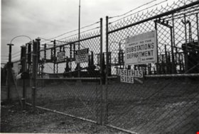
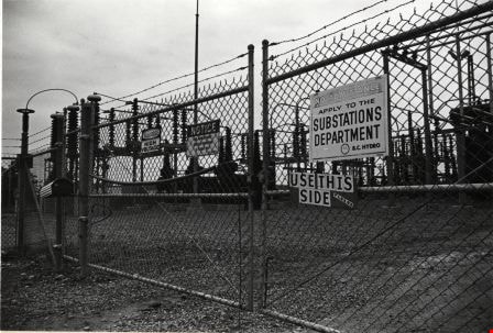
BC Hydro Substation
https://search.heritageburnaby.ca/link/archivedescription79356
- Repository
- City of Burnaby Archives
- Date
- September 22, 1976
- Collection/Fonds
- Burnaby Public Library Contemporary Visual Archive Project
- Description Level
- Item
- Physical Description
- 1 photograph : b&w ; 11 x 16 cm mounted on cardboard
- Scope and Content
- Photograph shows a BC Hydro substation located in Powerhouse Park near Beresford Street and Griffiths Avenue.
- Repository
- City of Burnaby Archives
- Date
- September 22, 1976
- Collection/Fonds
- Burnaby Public Library Contemporary Visual Archive Project
- Physical Description
- 1 photograph : b&w ; 11 x 16 cm mounted on cardboard
- Description Level
- Item
- Record No.
- 556-263
- Access Restriction
- No restrictions
- Reproduction Restriction
- Reproduce for fair dealing purposes only
- Accession Number
- 2013-13
- Scope and Content
- Photograph shows a BC Hydro substation located in Powerhouse Park near Beresford Street and Griffiths Avenue.
- Media Type
- Photograph
- Photographer
- Ross, Martha
- Notes
- Scope note taken directly from BPL photograph description.
- 1 b&w copy negative : 10 x 12.5 cm accompanying
- Geographic Access
- Griffiths Avenue
- Beresford Street
- Street Address
- 6970 Beresford Street
- Historic Neighbourhood
- Edmonds (Historic Neighbourhood)
- Planning Study Area
- Stride Avenue Area
Images
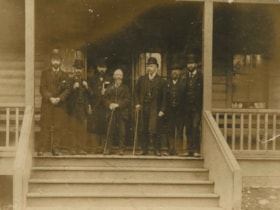
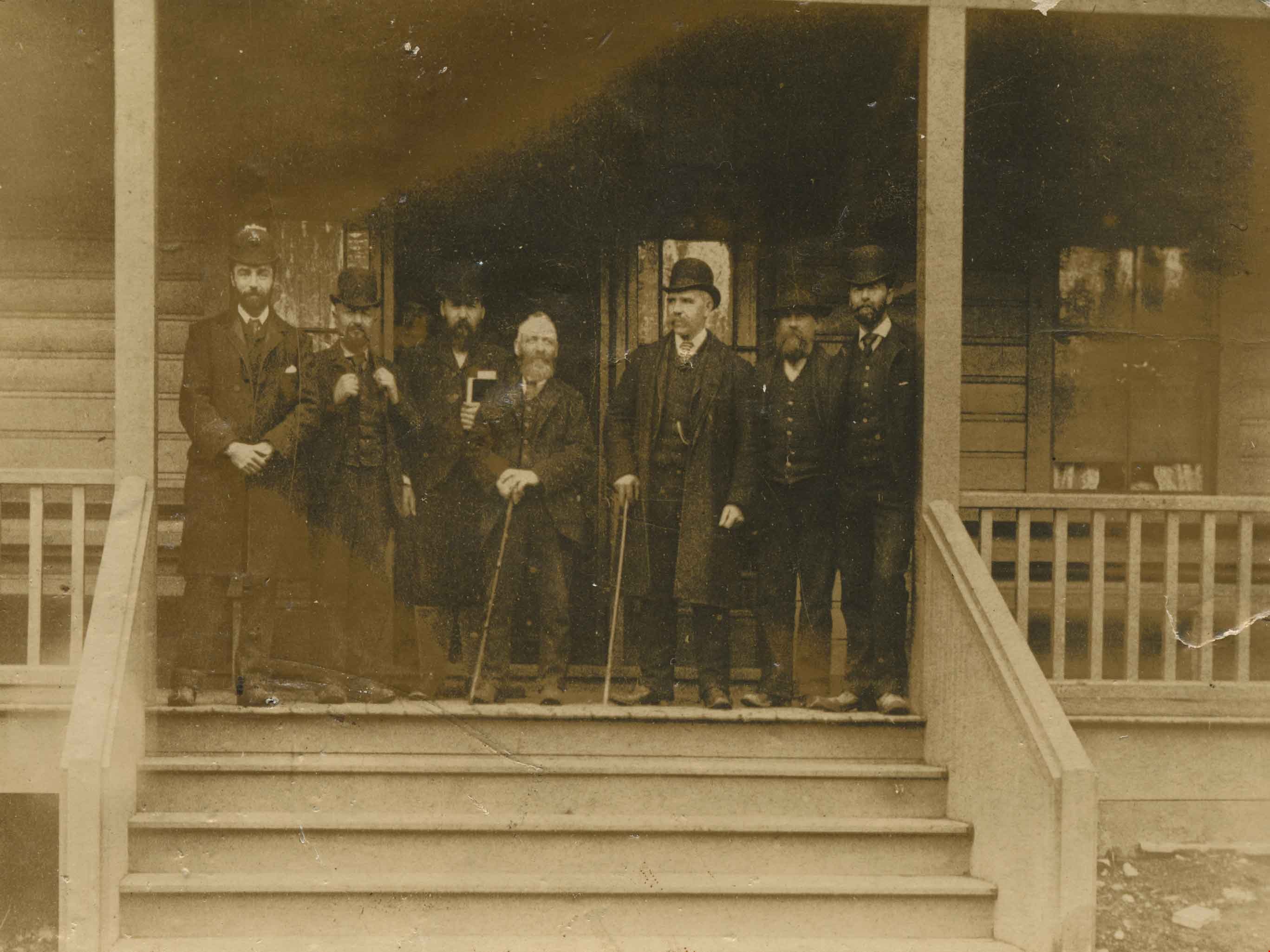
Burnaby Council
https://search.heritageburnaby.ca/link/archivedescription34065
- Repository
- City of Burnaby Archives
- Date
- 1892
- Collection/Fonds
- Burnaby Historical Society fonds
- Description Level
- Item
- Physical Description
- 1 photograph : sepia postcard ; 9 x 11.5 cm
- Scope and Content
- Photograph of Burnaby's first Council members on the steps of Sample's Boarding House, 6850 Beresford Street, near Griffiths Avenue and Kingsway. Left to right: L.C. Hill, William Brenchley, Alex Philip (clerk), Charles R. Shaw (Reeve), William McDermott, John Woolard, and Arthur de Windt Haszard.
- Repository
- City of Burnaby Archives
- Date
- 1892
- Collection/Fonds
- Burnaby Historical Society fonds
- Subseries
- Photographs subseries
- Physical Description
- 1 photograph : sepia postcard ; 9 x 11.5 cm
- Description Level
- Item
- Record No.
- 008-001
- Access Restriction
- No restrictions
- Reproduction Restriction
- No known restrictions
- Accession Number
- BHS2007-04
- Scope and Content
- Photograph of Burnaby's first Council members on the steps of Sample's Boarding House, 6850 Beresford Street, near Griffiths Avenue and Kingsway. Left to right: L.C. Hill, William Brenchley, Alex Philip (clerk), Charles R. Shaw (Reeve), William McDermott, John Woolard, and Arthur de Windt Haszard.
- Names
- Brenchley, William
- Haszard, Arthur de Windt
- Hill, Louis Claude "Claude"
- McDermott, William
- Philip, Alex
- Shaw, Charles R. "Chas"
- Woolard, John
- Media Type
- Photograph
- Notes
- Title based on contents of photograph
- Geographic Access
- Beresford Street
- Street Address
- 6850 Beresford Street
- Historic Neighbourhood
- Edmonds (Historic Neighbourhood)
- Planning Study Area
- Kingsway-Beresford Area
Images
![Burnaby Substation, [September 1907] thumbnail](/media/hpo/_Data/_Archives_Images/_Unrestricted/251/293-002.jpg?width=280)
Burnaby Substation
https://search.heritageburnaby.ca/link/archivedescription36541
- Repository
- City of Burnaby Archives
- Date
- [September 1907]
- Collection/Fonds
- Burnaby Historical Society fonds
- Description Level
- Item
- Physical Description
- 1 photograph : b&w postcard ; 7.5 x 13 cm
- Scope and Content
- Photographic postcard of the British Columbia Electric Railway Company's Burnaby Substation that was built in 1903 and put into operation to receive and distribute power from the B.C.E.R. Buntzen Lake power dam. The electric lines came across the inlet at Barnet, along the Barnet-Hastings Road to S…
- Repository
- City of Burnaby Archives
- Date
- [September 1907]
- Collection/Fonds
- Burnaby Historical Society fonds
- Subseries
- John DeForest subseries
- Physical Description
- 1 photograph : b&w postcard ; 7.5 x 13 cm
- Description Level
- Item
- Record No.
- 293-002
- Access Restriction
- No restrictions
- Reproduction Restriction
- No known restrictions
- Accession Number
- BHS1992-30
- Scope and Content
- Photographic postcard of the British Columbia Electric Railway Company's Burnaby Substation that was built in 1903 and put into operation to receive and distribute power from the B.C.E.R. Buntzen Lake power dam. The electric lines came across the inlet at Barnet, along the Barnet-Hastings Road to Sperling Avenue (built for this project and called Pole Line Road) and then south to this site at the corner of Griffiths and the old Central Park interurban line (later this section was called the Highland Park line). This substation was constructed to convert the alternating current being delivered from the Buntzen power plant to direct current for the operation of the tram cars operating on the Central Park interurban route. The new brick substation replaced the wood fed steam powered 1891 Powerhouse that operated south of this site, across the tracks until its closure on May 31,1905. It was demolised in the late 1920s. This brick substation originally known as the Burnaby Substation, eventually became known as the Newell Substation. The original brick building was replaced by a new structure in 1930, which was demolished in the 1960s in favour of the open field substation that continues to operate on the same site today at 7260 Griffiths Avenue.
- Subjects
- Buildings - Industrial - Powerhouses
- Media Type
- Photograph
- Notes
- Title based on contents of photograph
- Geographic Access
- Griffiths Avenue
- Historic Neighbourhood
- Edmonds (Historic Neighbourhood)
- Planning Study Area
- Stride Avenue Area
Images
![Burnaby Substation, [September 1907] thumbnail](/media/hpo/_Data/_Archives_Images/_Unrestricted/251/293-002.jpg)

Edison Road Power House
https://search.heritageburnaby.ca/link/archivedescription36086
- Repository
- City of Burnaby Archives
- Date
- 1893 (date of original), copied November 26, 1975
- Collection/Fonds
- Burnaby Historical Society fonds
- Description Level
- Item
- Physical Description
- 1 photograph : b&w ; 10.5 x 14 cm print
- Scope and Content
- Photograph of the Edison Road Power House, of the Westminster and Vancouver Tramway Co. Ltd., the first electric interurban street railway in North America. This power house stood between Vancouver Road (Kingsway) and the line to Vancouver. (Edison Road is now Griffiths Avenue).
- Repository
- City of Burnaby Archives
- Date
- 1893 (date of original), copied November 26, 1975
- Collection/Fonds
- Burnaby Historical Society fonds
- Subseries
- Columbian Newspaper subseries
- Physical Description
- 1 photograph : b&w ; 10.5 x 14 cm print
- Description Level
- Item
- Record No.
- 222-009
- Access Restriction
- No restrictions
- Reproduction Restriction
- No known restrictions
- Accession Number
- BHS1989-19
- Scope and Content
- Photograph of the Edison Road Power House, of the Westminster and Vancouver Tramway Co. Ltd., the first electric interurban street railway in North America. This power house stood between Vancouver Road (Kingsway) and the line to Vancouver. (Edison Road is now Griffiths Avenue).
- Media Type
- Photograph
- Notes
- Title based on contents of photograph
- Geographic Access
- Griffiths Avenue
- Kingsway
- Historic Neighbourhood
- Edmonds (Historic Neighbourhood)
- Planning Study Area
- Kingsway-Beresford Area
Images

![England family home on Royal Oak Avenue, [between 1927 and 1930] (date of original) , copied 2020 thumbnail](/media/hpo/_Data/_BVM_Images/2020/2020_0009_0002_001.jpg?width=280)
England family home on Royal Oak Avenue
https://search.heritageburnaby.ca/link/museumdescription12230
- Repository
- Burnaby Village Museum
- Date
- [between 1927 and 1930] (date of original) , copied 2020
- Collection/Fonds
- Mary England fonds
- Description Level
- Item
- Physical Description
- 1 photograph (tiff) : b&w ; 600 dpi
- Scope and Content
- Photograph of a Craftsman style house located at 1906 Royal Oak Avenue near Victory Street in Burnaby (address was changed to 7353 Royal Oak Aveue after 1958). The house was built in 1914 and was the home of Alfred Henry and Mary England (nee Gooding). Alfred H. England died suddenly in 1917. Mary…
- Repository
- Burnaby Village Museum
- Collection/Fonds
- Mary England fonds
- Description Level
- Item
- Physical Description
- 1 photograph (tiff) : b&w ; 600 dpi
- Scope and Content
- Photograph of a Craftsman style house located at 1906 Royal Oak Avenue near Victory Street in Burnaby (address was changed to 7353 Royal Oak Aveue after 1958). The house was built in 1914 and was the home of Alfred Henry and Mary England (nee Gooding). Alfred H. England died suddenly in 1917. Mary England continued to live in the house before settling in a house that she had built on Griffiths Avenue in 1930.
- Subjects
- Buildings - Residential - Houses
- Geographic Access
- Royal Oak Avenue
- Victory Street
- Accession Code
- BV020.9.2
- Access Restriction
- No restrictions
- Reproduction Restriction
- May be restricted by third party rights
- Date
- [between 1927 and 1930] (date of original) , copied 2020
- Media Type
- Photograph
- Historic Neighbourhood
- Central Park (Historic Neighbourhood)
- Alta Vista (Historic Neighbourhood)
- Planning Study Area
- Clinton-Glenwood Area
- Scan Resolution
- 600
- Scan Date
- 12-Feb-20
- Scale
- 100
- Notes
- Title based on contents of photograph
Images
![England family home on Royal Oak Avenue, [between 1927 and 1930] (date of original) , copied 2020 thumbnail](/media/hpo/_Data/_BVM_Images/2020/2020_0009_0002_001.jpg)

Galaxie Collision Ltd.
https://search.heritageburnaby.ca/link/archivedescription79255
- Repository
- City of Burnaby Archives
- Date
- September 24, 1976
- Collection/Fonds
- Burnaby Public Library Contemporary Visual Archive Project
- Description Level
- Item
- Physical Description
- 1 photograph : b&w ; 11 x 16 cm mounted on cardboard
- Scope and Content
- Photograph shows a sign attached to an old automobile advertising Galaxie Collision Ltd. The car and sign are parked in a lot on the corner of Kingsway and Griffiths Avenue directing people to the business one block south of Kingsway at 7498A Griffiths Avenue.
- Repository
- City of Burnaby Archives
- Date
- September 24, 1976
- Collection/Fonds
- Burnaby Public Library Contemporary Visual Archive Project
- Physical Description
- 1 photograph : b&w ; 11 x 16 cm mounted on cardboard
- Description Level
- Item
- Record No.
- 556-224
- Access Restriction
- No restrictions
- Reproduction Restriction
- Reproduce for fair dealing purposes only
- Accession Number
- 2013-13
- Scope and Content
- Photograph shows a sign attached to an old automobile advertising Galaxie Collision Ltd. The car and sign are parked in a lot on the corner of Kingsway and Griffiths Avenue directing people to the business one block south of Kingsway at 7498A Griffiths Avenue.
- Names
- Galaxie Collision Ltd.
- Media Type
- Photograph
- Photographer
- Born, A. J.
- Notes
- Scope note taken directly from BPL photograph description.
- 1 b&w copy negative : 10 x 12.5 cm accompanying
- Geographic Access
- Kingsway
- Griffiths Avenue
- Street Address
- 7498 Griffiths Avenue
- Historic Neighbourhood
- Edmonds (Historic Neighbourhood)
- Planning Study Area
- Stride Avenue Area
Images


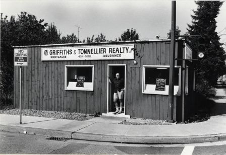
Griffiths & Tonnellier Realty Ltd.
https://search.heritageburnaby.ca/link/archivedescription79175
- Repository
- City of Burnaby Archives
- Date
- September 20, 1976
- Collection/Fonds
- Burnaby Public Library Contemporary Visual Archive Project
- Description Level
- Item
- Physical Description
- 1 photograph : b&w ; 11 x 16 cm mounted on cardboard
- Scope and Content
- Photograph shows Griffiths & Tonnellier Realty Ktd. at 4871 Imperial Street, near Griffiths Avenue. The building was originally constructed around 1945 and an extra office was added around 1950.
- Repository
- City of Burnaby Archives
- Date
- September 20, 1976
- Collection/Fonds
- Burnaby Public Library Contemporary Visual Archive Project
- Physical Description
- 1 photograph : b&w ; 11 x 16 cm mounted on cardboard
- Description Level
- Item
- Record No.
- 556-190
- Access Restriction
- No restrictions
- Reproduction Restriction
- Reproduce for fair dealing purposes only
- Accession Number
- 2013-13
- Scope and Content
- Photograph shows Griffiths & Tonnellier Realty Ktd. at 4871 Imperial Street, near Griffiths Avenue. The building was originally constructed around 1945 and an extra office was added around 1950.
- Media Type
- Photograph
- Photographer
- McCarron, John
- Notes
- Scope note taken directly from BPL photograph description.
- 1 b&w copy negative : 10 x 12.5 cm accompanying
- Geographic Access
- Imperial Street
- Street Address
- 4871 Imperial Street
- Historic Neighbourhood
- Edmonds (Historic Neighbourhood)
- Planning Study Area
- Kingsway-Beresford Area
Images
House at Beresford Street and Griffiths Avenue
https://search.heritageburnaby.ca/link/archivedescription78981
- Repository
- City of Burnaby Archives
- Date
- September 22, 1976
- Collection/Fonds
- Burnaby Public Library Contemporary Visual Archive Project
- Description Level
- Item
- Physical Description
- 1 photograph : b&w ; 11 x 16 cm mounted on cardboard
- Scope and Content
- Photograph shows a house, built in 1930, on Beresford Street at the corner of Griffiths Avenue.
- Repository
- City of Burnaby Archives
- Date
- September 22, 1976
- Collection/Fonds
- Burnaby Public Library Contemporary Visual Archive Project
- Physical Description
- 1 photograph : b&w ; 11 x 16 cm mounted on cardboard
- Description Level
- Item
- Record No.
- 556-066
- Access Restriction
- No restrictions
- Reproduction Restriction
- Reproduce for fair dealing purposes only
- Accession Number
- 2013-13
- Scope and Content
- Photograph shows a house, built in 1930, on Beresford Street at the corner of Griffiths Avenue.
- Media Type
- Photograph
- Photographer
- Ross, Martha
- Notes
- Scope note taken directly from BPL photograph description.
- 1 b&w copy negative : 10 x 12.5 cm accompanying
- Geographic Access
- Griffiths Avenue
- Beresford Street
- Historic Neighbourhood
- Edmonds (Historic Neighbourhood)
- Planning Study Area
- Stride Avenue Area
Images
![Interior of the Burnaby Substation, [September 1908] thumbnail](/media/hpo/_Data/_Archives_Images/_Unrestricted/251/293-003.jpg?width=280)
Interior of the Burnaby Substation
https://search.heritageburnaby.ca/link/archivedescription36542
- Repository
- City of Burnaby Archives
- Date
- [September 1908]
- Collection/Fonds
- Burnaby Historical Society fonds
- Description Level
- Item
- Physical Description
- 1 photograph : b&w postcard ; 7.5 x 13 cm
- Scope and Content
- Photographic postcard of the interior of the British Columbia Electric Railway Company's Burnaby Substation that was built in 1903 and put into operation to receive and distribute power from the B.C.E.R. Buntzen Lake power dam. The electric lines came across the inlet at Barnet, along the Barnet-Ha…
- Repository
- City of Burnaby Archives
- Date
- [September 1908]
- Collection/Fonds
- Burnaby Historical Society fonds
- Subseries
- John DeForest subseries
- Physical Description
- 1 photograph : b&w postcard ; 7.5 x 13 cm
- Description Level
- Item
- Record No.
- 293-003
- Access Restriction
- No restrictions
- Reproduction Restriction
- No known restrictions
- Accession Number
- BHS1992-30
- Scope and Content
- Photographic postcard of the interior of the British Columbia Electric Railway Company's Burnaby Substation that was built in 1903 and put into operation to receive and distribute power from the B.C.E.R. Buntzen Lake power dam. The electric lines came across the inlet at Barnet, along the Barnet-Hastings Road to Sperling Avenue (built for this project and called Pole Line Road) and then south to this site at the corner of Griffiths and the old Central Park interurban line (later this section was called the Highland Park line). This substation was constructed to convert the alternating current being delivered from the Buntzen power plant to direct current for the operation of the tram cars operating on the Central Park interurban route. The new brick substation replaced the wood fed steam powered 1891 Powerhouse that operated south of this site, across the tracks until its closure on May 31,1905. It was demolised in the late 1920s. This brick substation originally known as the Burnaby Substation, eventually became known as the Newell Substation. The original brick building was replaced by a new structure in 1930, which was demolished in the 1960s in favour of the open field substation that continues to operate on the same site today at 7260 Griffiths Avenue.
- Subjects
- Buildings - Industrial - Powerhouses
- Media Type
- Photograph
- Notes
- Title based on contents of photograph
- Geographic Access
- Griffiths Avenue
- Historic Neighbourhood
- Edmonds (Historic Neighbourhood)
- Planning Study Area
- Stride Avenue Area
Images
![Interior of the Burnaby Substation, [September 1908] thumbnail](/media/hpo/_Data/_Archives_Images/_Unrestricted/251/293-003.jpg)
![Interior of the Burnaby Substation, [September 1908] thumbnail](/media/hpo/_Data/_Archives_Images/_Unrestricted/251/293-004.jpg?width=280)
Interior of the Burnaby Substation
https://search.heritageburnaby.ca/link/archivedescription36543
- Repository
- City of Burnaby Archives
- Date
- [September 1908]
- Collection/Fonds
- Burnaby Historical Society fonds
- Description Level
- Item
- Physical Description
- 1 photograph : b&w postcard ; 7.5 x 13 cm
- Scope and Content
- Photographic postcard of the interior of the British Columbia Electric Railway Company's Burnaby Substation that was built in 1903 and put into operation to receive and distribute power from the B.C.E.R. Buntzen Lake power dam. The electric lines came across the inlet at Barnet, along the Barnet-Ha…
- Repository
- City of Burnaby Archives
- Date
- [September 1908]
- Collection/Fonds
- Burnaby Historical Society fonds
- Subseries
- John DeForest subseries
- Physical Description
- 1 photograph : b&w postcard ; 7.5 x 13 cm
- Description Level
- Item
- Record No.
- 293-004
- Access Restriction
- No restrictions
- Reproduction Restriction
- No known restrictions
- Accession Number
- BHS1992-30
- Scope and Content
- Photographic postcard of the interior of the British Columbia Electric Railway Company's Burnaby Substation that was built in 1903 and put into operation to receive and distribute power from the B.C.E.R. Buntzen Lake power dam. The electric lines came across the inlet at Barnet, along the Barnet-Hastings Road to Sperling Avenue (built for this project and called Pole Line Road) and then south to this site at the corner of Griffiths and the old Central Park interurban line (later this section was called the Highland Park line). This substation was constructed to convert the alternating current being delivered from the Buntzen power plant to direct current for the operation of the tram cars operating on the Central Park interurban route. The new brick substation replaced the wood fed steam powered 1891 Powerhouse that operated south of this site, across the tracks until its closure on May 31,1905. It was demolised in the late 1920s. This brick substation originally known as the Burnaby Substation, eventually became known as the Newell Substation. The original brick building was replaced by a new structure in 1930, which was demolished in the 1960s in favour of the open field substation that continues to operate on the same site today at 7260 Griffiths Avenue.
- Subjects
- Buildings - Industrial - Powerhouses
- Media Type
- Photograph
- Notes
- Title based on contents of photograph
- Geographic Access
- Griffiths Avenue
- Historic Neighbourhood
- Edmonds (Historic Neighbourhood)
- Planning Study Area
- Stride Avenue Area
Images
![Interior of the Burnaby Substation, [September 1908] thumbnail](/media/hpo/_Data/_Archives_Images/_Unrestricted/251/293-004.jpg)

Interior of the Burnaby Substation
https://search.heritageburnaby.ca/link/archivedescription36544
- Repository
- City of Burnaby Archives
- Date
- 1907
- Collection/Fonds
- Burnaby Historical Society fonds
- Description Level
- Item
- Physical Description
- 1 photograph : sepia ; 12 x 17cm, mounted on board 22 x 27 cm
- Scope and Content
- Photograph of the interior of the British Columbia Electric Railway Company's Burnaby Substation that was built in 1903 and put into operation to receive and distribute power from the B.C.E.R. Buntzen Lake power dam. The electric lines came across the inlet at Barnet, along the Barnet-Hastings Road…
- Repository
- City of Burnaby Archives
- Date
- 1907
- Collection/Fonds
- Burnaby Historical Society fonds
- Subseries
- John DeForest subseries
- Physical Description
- 1 photograph : sepia ; 12 x 17cm, mounted on board 22 x 27 cm
- Description Level
- Item
- Record No.
- 293-005
- Access Restriction
- No restrictions
- Reproduction Restriction
- No known restrictions
- Accession Number
- BHS1992-30
- Scope and Content
- Photograph of the interior of the British Columbia Electric Railway Company's Burnaby Substation that was built in 1903 and put into operation to receive and distribute power from the B.C.E.R. Buntzen Lake power dam. The electric lines came across the inlet at Barnet, along the Barnet-Hastings Road to Sperling Avenue (built for this project and called Pole Line Road) and then south to this site at the corner of Griffiths and the old Central Park interurban line (later this section was called the Highland Park line). This substation was constructed to convert the alternating current being delivered from the Buntzen power plant to direct current for the operation of the tram cars operating on the Central Park interurban route. The new brick substation replaced the wood fed steam powered 1891 Powerhouse that operated south of this site, across the tracks until its closure on May 31,1905. It was demolised in the late 1920s. This brick substation originally known as the Burnaby Substation, eventually became known as the Newell Substation. The original brick building was replaced by a new structure in 1930, which was demolished in the 1960s in favour of the open field substation that continues to operate on the same site today at 7260 Griffiths Avenue.
- Subjects
- Buildings - Industrial - Powerhouses
- Media Type
- Photograph
- Notes
- Title based on contents of photograph
- Photographer's handwritten note (on the negative causing it to show) on recto of photograph reads: "Burnaby Substation/ B.C.E.R.C/O"
- Geographic Access
- Griffiths Avenue
- Historic Neighbourhood
- Edmonds (Historic Neighbourhood)
- Planning Study Area
- Stride Avenue Area
Images


Lillias Urquhart
https://search.heritageburnaby.ca/link/archivedescription35281
- Repository
- City of Burnaby Archives
- Date
- 1929 (date of original), copied 1986
- Collection/Fonds
- Burnaby Historical Society fonds
- Description Level
- Item
- Physical Description
- 1 photograph : b&w ; 12.7 x 17.8 cm print
- Scope and Content
- Photograph of Mrs. Lillias Urquhart in the garden at "Rowanlea," the family home. Rowan trees line the street alongside telephone poles. Lillias Urquhart was married to William Urquhart. The house was previously numbered 2674, then changed to 6625, and later 6637 Griffiths Avenue.
- Repository
- City of Burnaby Archives
- Date
- 1929 (date of original), copied 1986
- Collection/Fonds
- Burnaby Historical Society fonds
- Subseries
- Pioneer Tales subseries
- Physical Description
- 1 photograph : b&w ; 12.7 x 17.8 cm print
- Description Level
- Item
- Record No.
- 204-138
- Access Restriction
- No restrictions
- Reproduction Restriction
- No known restrictions
- Accession Number
- BHS1988-03
- Scope and Content
- Photograph of Mrs. Lillias Urquhart in the garden at "Rowanlea," the family home. Rowan trees line the street alongside telephone poles. Lillias Urquhart was married to William Urquhart. The house was previously numbered 2674, then changed to 6625, and later 6637 Griffiths Avenue.
- Subjects
- Plants - Trees
- Names
- Urquhart, Lillias
- Media Type
- Photograph
- Notes
- Title based on contents of photograph
- Geographic Access
- Griffiths Avenue
- Street Address
- 6637 Griffiths Avenue
- Historic Neighbourhood
- Edmonds (Historic Neighbourhood)
- Planning Study Area
- Kingsway-Beresford Area
Images
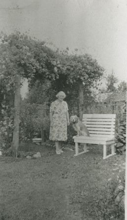
Lillias Urquhart
https://search.heritageburnaby.ca/link/archivedescription35282
- Repository
- City of Burnaby Archives
- Date
- 1929 (date of original), copied 1986
- Collection/Fonds
- Burnaby Historical Society fonds
- Description Level
- Item
- Physical Description
- 1 photograph : b&w ; 12.7 x 17.8 cm print
- Scope and Content
- Photograph of Mrs. Lillias Urquhart under a rose trellis with her pet dog, Fluff. The home was located at Griffiths Avenue and Burford Street and was called "Rowanlea." The house was previously numbered 2674, then changed to 6625, and later 6637 Griffiths Avenue.
- Repository
- City of Burnaby Archives
- Date
- 1929 (date of original), copied 1986
- Collection/Fonds
- Burnaby Historical Society fonds
- Subseries
- Pioneer Tales subseries
- Physical Description
- 1 photograph : b&w ; 12.7 x 17.8 cm print
- Description Level
- Item
- Record No.
- 204-139
- Access Restriction
- No restrictions
- Reproduction Restriction
- No known restrictions
- Accession Number
- BHS1988-03
- Scope and Content
- Photograph of Mrs. Lillias Urquhart under a rose trellis with her pet dog, Fluff. The home was located at Griffiths Avenue and Burford Street and was called "Rowanlea." The house was previously numbered 2674, then changed to 6625, and later 6637 Griffiths Avenue.
- Names
- Urquhart, Lillias
- Media Type
- Photograph
- Notes
- Title based on contents of photograph
- Geographic Access
- Griffiths Avenue
- Street Address
- 6637 Griffiths Avenue
- Historic Neighbourhood
- Edmonds (Historic Neighbourhood)
- Planning Study Area
- Kingsway-Beresford Area
Images
Mary England fonds
https://search.heritageburnaby.ca/link/museumdescription12234
- Repository
- Burnaby Village Museum
- Date
- 1915-1934 (date of originals), copied 2020
- Collection/Fonds
- Mary England fonds
- Description Level
- Fonds
- Physical Description
- 5 photographs (tiffs) : b&w ; 600 dpi
- Scope and Content
- Fonds consists of a small collection of photographs documenting the life of Mary England (nee Gooding). Photographs include the house of Mary and Alfred England on Royal Oak Avenue; Mary England's house on Griffiths Avenue and of Mary and Alfred England ca. 1915.
- Repository
- Burnaby Village Museum
- Collection/Fonds
- Mary England fonds
- Description Level
- Fonds
- Physical Description
- 5 photographs (tiffs) : b&w ; 600 dpi
- Scope and Content
- Fonds consists of a small collection of photographs documenting the life of Mary England (nee Gooding). Photographs include the house of Mary and Alfred England on Royal Oak Avenue; Mary England's house on Griffiths Avenue and of Mary and Alfred England ca. 1915.
- History
- Mary England was born to parents Robert and Mary (nee Morgan) Gooding in Wales on March 30, 1879. Mary and her brother Robert Nathaniel Gooding came to Canada from the U.K. in 1905. While living in Canada, Mary met and married Alfred Henry England. The couple lived in a house on Hornby Street in Vancouver which they ran as a boarding house. In 1914, Mary and Alfred moved to a house located at 1906 Royal Oak Avenue and Victory Street in Burnaby (house number changed to7353 after 1958). Alfred worked in the composing room at the Vancouver Province until his untimely death in October 1917. Mary continued to reside in their home on Royal Oak until 1930 when she built and moved into a house on Griffiths Avenue in Burnaby. Mary was employed as an office clerk with the Municipality of the District of Burnaby. Mary England was an active member of the community including becoming the first president of the West Burnaby auxiliary of the Victorian Order of Nurses between 1915 and 1917 and a founding member of the Burnaby Civic Employees Union in 1919. She often spoke out about issues that impacted female workers, and felt that the wages for the inside workers, many of whom were women, were inadequate. Often on England’s motions, the Union from time to time brought to Council concerns about the treatment of women, including behaviour of managers in the general office, suspension of a young woman for her choice of clothes, and in 1931, health issues that warranted “accommodation…for the ladies in the Hall.” Mary served as president of the union from 1922-1923 and held leadership roles in the New Westminster Trades and Labour Council. Mary served as union secretary until 1934, after losing her position as municipal employee during the Great Depression. She and the union tried to fight her dismissal, but to no avail as they were told that the reasons were purely economic. The union honoured her with a Life time membership at St. Alban's Hall a few months later. Mary died in Burnaby in 1959 at the age of 79 years.
- Responsibility
- England, Mary
- Accession Code
- BV020.9
- Date
- 1915-1934 (date of originals), copied 2020
- Media Type
- Photograph
- Notes
- Title based on contents of fonds
![Mary England's home, [1934] (date of original) , copied 2020 thumbnail](/media/hpo/_Data/_BVM_Images/2020/2020_0009_0004_001.jpg?width=280)
Mary England's home
https://search.heritageburnaby.ca/link/museumdescription12232
- Repository
- Burnaby Village Museum
- Date
- [1934] (date of original) , copied 2020
- Collection/Fonds
- Mary England fonds
- Description Level
- Item
- Physical Description
- 1 photograph (tiff) : b&w ; 600 dpi
- Scope and Content
- Photograph of Mary England (nee Gooding) standing outside on the lawn of her home located at 2125 Griffiths Street in Burnaby. The house was built by Mary England in 1930 in a revival style and has been recognized on the Burnaby Community Heritage Register.
- Repository
- Burnaby Village Museum
- Collection/Fonds
- Mary England fonds
- Description Level
- Item
- Physical Description
- 1 photograph (tiff) : b&w ; 600 dpi
- Scope and Content
- Photograph of Mary England (nee Gooding) standing outside on the lawn of her home located at 2125 Griffiths Street in Burnaby. The house was built by Mary England in 1930 in a revival style and has been recognized on the Burnaby Community Heritage Register.
- Names
- England, Mary
- Geographic Access
- Griffiths Avenue
- Street Address
- 7276 Griffiths Drive
- Accession Code
- BV020.9.4
- Access Restriction
- No restrictions
- Reproduction Restriction
- May be restricted by third party rights
- Date
- [1934] (date of original) , copied 2020
- Media Type
- Photograph
- Historic Neighbourhood
- Edmonds (Historic Neighbourhood)
- Planning Study Area
- Stride Avenue Area
- Scan Resolution
- 600
- Scan Date
- 12-Feb-20
- Scale
- 100
- Notes
- Title based on contents of photograph
Images
![Mary England's home, [1934] (date of original) , copied 2020 thumbnail](/media/hpo/_Data/_BVM_Images/2020/2020_0009_0004_001.jpg)
![Men riding bicycles, [1914] thumbnail](/media/hpo/_Data/_BVM_Images/1971/197200110015.jpg?width=280)
Men riding bicycles
https://search.heritageburnaby.ca/link/museumdescription3101
- Repository
- Burnaby Village Museum
- Date
- [1914]
- Collection/Fonds
- Burnaby Village Museum Photograph collection
- Description Level
- Item
- Physical Description
- 1 photograph : b&w glass negative ; 16.4 x 21.3 cm
- Scope and Content
- Photograph of a paved road lined with electric poles on both sides and a wood plank sidewalk on one side of the road. There are two men in suits and bowler hats riding bicycles and another man in suit and bowler hat standing on the sidewalk. The sun is casting long shadows from the left side of the…
- Repository
- Burnaby Village Museum
- Collection/Fonds
- Burnaby Village Museum Photograph collection
- Description Level
- Item
- Physical Description
- 1 photograph : b&w glass negative ; 16.4 x 21.3 cm
- Scope and Content
- Photograph of a paved road lined with electric poles on both sides and a wood plank sidewalk on one side of the road. There are two men in suits and bowler hats riding bicycles and another man in suit and bowler hat standing on the sidewalk. The sun is casting long shadows from the left side of the photograph. An earlier catalogue record from 1988 conjectures that the photograph may be of Kingsway in Burnaby, possibly near Gilley looking east towards Griffiths Avenue. The record also dates the negative, ca. 1914.
- Geographic Access
- Kingsway
- Griffiths Avenue
- Accession Code
- HV972.11.15
- Access Restriction
- No restrictions
- Reproduction Restriction
- No known restrictions
- Date
- [1914]
- Media Type
- Photograph
- Historic Neighbourhood
- Edmonds (Historic Neighbourhood)
- Planning Study Area
- Kingsway-Beresford Area
- Scan Resolution
- 300
- Scan Date
- 14/8/2006
- Scale
- 100
- Notes
- Title based on contents of photograph
- 1 b&w contact print accompanying negative
Images
![Men riding bicycles, [1914] thumbnail](/media/hpo/_Data/_BVM_Images/1971/197200110015.jpg)
![Myles of Beans Cafe & Coffee House, [2002] thumbnail](/media/hpo/_Data/_Archives_Images/_Unrestricted/535/535-2340.jpg?width=280)
Myles of Beans Cafe & Coffee House
https://search.heritageburnaby.ca/link/archivedescription96741
- Repository
- City of Burnaby Archives
- Date
- [2002]
- Collection/Fonds
- Burnaby NewsLeader photograph collection
- Description Level
- Item
- Physical Description
- 1 photograph (tiff) : col.
- Scope and Content
- Photograph of Kim Mostat posing outside of Myles of Beans Cafe & Coffee House on Kingsway & Griffiths Avenue. Mostat holds a musical instrument case and the cafe's sign is visible behind Mostat.
- Repository
- City of Burnaby Archives
- Date
- [2002]
- Collection/Fonds
- Burnaby NewsLeader photograph collection
- Physical Description
- 1 photograph (tiff) : col.
- Description Level
- Item
- Record No.
- 535-2340
- Access Restriction
- No restrictions
- Reproduction Restriction
- No restrictions
- Accession Number
- 2018-12
- Scope and Content
- Photograph of Kim Mostat posing outside of Myles of Beans Cafe & Coffee House on Kingsway & Griffiths Avenue. Mostat holds a musical instrument case and the cafe's sign is visible behind Mostat.
- Media Type
- Photograph
- Photographer
- Bartel, Mario
- Notes
- Title based on caption
- Collected by editorial for use in a May 2002 issue of the Burnaby NewsLeader
- Caption from metadata: "Kim Mostat, the owner of Myles of Beans Cafe, in Burnaby's Middletown area has kept her coffee shop alive as a venue for local musicians and poets to perform their works."
- Geographic Access
- Kingsway
- Historic Neighbourhood
- Edmonds (Historic Neighbourhood)
- Planning Study Area
- Stride Avenue Area
Images
![Myles of Beans Cafe & Coffee House, [2002] thumbnail](/media/hpo/_Data/_Archives_Images/_Unrestricted/535/535-2340.jpg)

Peggy Urquhart
https://search.heritageburnaby.ca/link/archivedescription35280
- Repository
- City of Burnaby Archives
- Date
- 1924 (date of original), copied 1986
- Collection/Fonds
- Burnaby Historical Society fonds
- Description Level
- Item
- Physical Description
- 1 photograph : b&w ; 12.7 x 17.8 cm print
- Scope and Content
- Photograph of Peggy Urquhart with a pet dog and cat in front of the family home, "Rowanlea." William Urquhart built this house for his family around 1919 at Griffiths Avenue and Burford Street (Edmonds area). The house was previously numbered 2674, then changed to 6625, and later 6637 Griffiths A…
- Repository
- City of Burnaby Archives
- Date
- 1924 (date of original), copied 1986
- Collection/Fonds
- Burnaby Historical Society fonds
- Subseries
- Pioneer Tales subseries
- Physical Description
- 1 photograph : b&w ; 12.7 x 17.8 cm print
- Description Level
- Item
- Record No.
- 204-137
- Access Restriction
- No restrictions
- Reproduction Restriction
- No known restrictions
- Accession Number
- BHS1988-03
- Scope and Content
- Photograph of Peggy Urquhart with a pet dog and cat in front of the family home, "Rowanlea." William Urquhart built this house for his family around 1919 at Griffiths Avenue and Burford Street (Edmonds area). The house was previously numbered 2674, then changed to 6625, and later 6637 Griffiths Avenue.
- Subjects
- Animals - Cats
- Animals - Dogs
- Buildings - Residential - Houses
- Geographic Features - Gardens
- Media Type
- Photograph
- Notes
- Title based on contents of photograph
- Geographic Access
- Griffiths Avenue
- Street Address
- 6637 Griffiths Avenue
- Historic Neighbourhood
- Edmonds (Historic Neighbourhood)
- Planning Study Area
- Kingsway-Beresford Area
Images
