Narrow Results By
Subject
- Accidents - Train Accidents 5
- Agriculture - Farms 1
- Buildings - Agricultural - Barns 1
- Buildings - Industrial - Powerhouses 1
- Buildings - Residential - Cabins 1
- Buildings - Residential - Houses 1
- Construction - Railroad Construction 3
- First Nations reserves - British Columbia 4
- Geographic Features - Roads 2
- Indigenous peoples - Indian Territory 4
- Industries - Forestry 1
- Industries - Logging/lumber 1
![GN 1483, [between 1930 and 1949] thumbnail](/media/hpo/_Data/_BVM_Images/1985/1985_6114_0032_001.jpg?width=280)
GN 1483
https://search.heritageburnaby.ca/link/museumdescription3260
- Repository
- Burnaby Village Museum
- Date
- [between 1930 and 1949]
- Collection/Fonds
- Burnaby Village Museum Photograph collection
- Description Level
- Item
- Physical Description
- 1 photograph : b&w ; 5.5 x 8 cm
- Scope and Content
- Photograph of Great Northern Railway locomotive no. 1483 at an unidentified location.
- Repository
- Burnaby Village Museum
- Collection/Fonds
- Burnaby Village Museum Photograph collection
- Description Level
- Item
- Physical Description
- 1 photograph : b&w ; 5.5 x 8 cm
- Scope and Content
- Photograph of Great Northern Railway locomotive no. 1483 at an unidentified location.
- Names
- Great Northern Railway
- Accession Code
- BV985.6114.32
- Access Restriction
- No restrictions
- Reproduction Restriction
- No known restrictions
- Date
- [between 1930 and 1949]
- Media Type
- Photograph
- Scan Resolution
- 600
- Scan Date
- 2024-03-12
- Notes
- Title based on note written on verso of photograph
- Handwritten note in black ball-point pen on verso of photograph reads: "GN 1483"
- Stamp on verso of photograph reads: "694"
Images
![GN 1483, [between 1930 and 1949] thumbnail](/media/hpo/_Data/_BVM_Images/1985/1985_6114_0032_001.jpg)
![GN no. 1, [between 1930 and 1949] thumbnail](/media/hpo/_Data/_BVM_Images/1985/1985_6114_0027_001.jpg?width=280)
GN no. 1
https://search.heritageburnaby.ca/link/museumdescription3255
- Repository
- Burnaby Village Museum
- Date
- [between 1930 and 1949]
- Collection/Fonds
- Burnaby Village Museum Photograph collection
- Description Level
- Item
- Physical Description
- 1 photograph : b&w ; 5.5 x 8 cm
- Scope and Content
- Photograph of Great Northern Railway locomotive no. 1 at an unidentified location.
- Repository
- Burnaby Village Museum
- Collection/Fonds
- Burnaby Village Museum Photograph collection
- Description Level
- Item
- Physical Description
- 1 photograph : b&w ; 5.5 x 8 cm
- Scope and Content
- Photograph of Great Northern Railway locomotive no. 1 at an unidentified location.
- Names
- Great Northern Railway
- Accession Code
- BV985.6114.27
- Access Restriction
- No restrictions
- Reproduction Restriction
- No known restrictions
- Date
- [between 1930 and 1949]
- Media Type
- Photograph
- Scan Resolution
- 600
- Scan Date
- 2024-03-12
- Notes
- Title based on note written on verso of photograph
- Handwritten note in black ball-point pen on verso of photograph reads: "GN # 1"
- Stamp on verso of photograph reads: "840"
Images
![GN no. 1, [between 1930 and 1949] thumbnail](/media/hpo/_Data/_BVM_Images/1985/1985_6114_0027_001.jpg)
![Great Northern Railroad, [1903] thumbnail](/media/hpo/_Data/_Archives_Images/_Unrestricted/477/477-837.jpg?width=280)
Great Northern Railroad
https://search.heritageburnaby.ca/link/archivedescription39518
- Repository
- City of Burnaby Archives
- Date
- [1903]
- Collection/Fonds
- Peers Family and Hill Family fonds
- Description Level
- Item
- Physical Description
- 1 photograph : sepia ; 5 x 5 cm on page 21.5 x 28 cm (pasted in album)
- Scope and Content
- Photograph of men working on the Great Northern Railroad line that ran through the Burnaby Lake area by 1904.
- Repository
- City of Burnaby Archives
- Date
- [1903]
- Collection/Fonds
- Peers Family and Hill Family fonds
- Physical Description
- 1 photograph : sepia ; 5 x 5 cm on page 21.5 x 28 cm (pasted in album)
- Description Level
- Item
- Record No.
- 477-837
- Access Restriction
- No restrictions
- Reproduction Restriction
- No known restrictions
- Accession Number
- 2007-12
- Scope and Content
- Photograph of men working on the Great Northern Railroad line that ran through the Burnaby Lake area by 1904.
- Names
- Great Northern Railway
- Media Type
- Photograph
- Notes
- Title based on contents of photograph
- Historic Neighbourhood
- Burnaby Lake (Historic Neighbourhood)
Images
![Great Northern Railroad, [1903] thumbnail](/media/hpo/_Data/_Archives_Images/_Unrestricted/477/477-837.jpg)
![Railway embankment, [1914] thumbnail](/media/hpo/_Data/_BVM_Images/1971/197200110004.jpg?width=280)
Railway embankment
https://search.heritageburnaby.ca/link/museumdescription1057
- Repository
- Burnaby Village Museum
- Date
- [1914]
- Collection/Fonds
- Burnaby Village Museum Photograph collection
- Description Level
- Item
- Physical Description
- 1 photograph : b&w glass negative ; 14.8 x 19.7 cm
- Scope and Content
- Photograph of a railway embankment. The railway is winding out of the picture frame with the road lined with electric posts running almost parallel to the rail tracks. An earlier catalogue record from 1988 notes that this is the view of the Great Northern Railway and cut along North Road just nort…
- Repository
- Burnaby Village Museum
- Collection/Fonds
- Burnaby Village Museum Photograph collection
- Description Level
- Item
- Physical Description
- 1 photograph : b&w glass negative ; 14.8 x 19.7 cm
- Scope and Content
- Photograph of a railway embankment. The railway is winding out of the picture frame with the road lined with electric posts running almost parallel to the rail tracks. An earlier catalogue record from 1988 notes that this is the view of the Great Northern Railway and cut along North Road just north of the Brunette River, looking southeast toward Coquitlam from Burnaby.
- Subjects
- Transportation - Rail
- Names
- Great Northern Railway
- Geographic Access
- North Road
- Accession Code
- HV972.11.4
- Access Restriction
- No restrictions
- Reproduction Restriction
- No known restrictions
- Date
- [1914]
- Media Type
- Photograph
- Planning Study Area
- Cariboo-Armstrong Area
- Related Material
- for another view of the same railway embankment, see HV972.11.2
- Scan Resolution
- 300
- Scan Date
- 14/8/2006
- Scale
- 100
- Notes
- Title based on contents of photograph
- 1 b&w contact print accompanying negative
Images
![Railway embankment, [1914] thumbnail](/media/hpo/_Data/_BVM_Images/1971/197200110004.jpg)
![Railway embankment, [1914] thumbnail](/media/hpo/_Data/_BVM_Images/1971/197200110002.jpg?width=280)
Railway embankment
https://search.heritageburnaby.ca/link/museumdescription3089
- Repository
- Burnaby Village Museum
- Date
- [1914]
- Collection/Fonds
- Burnaby Village Museum Photograph collection
- Description Level
- Item
- Physical Description
- 1 photograph : b&w glass negative ; 14.8 x 20.1 cm
- Scope and Content
- Photograph of a railway embankment. In the foreground is the railway, and in the midground a steep bluff, on top of which an unidentified man in a suit and a bowler hat is standing. There appears to be a road lined with electric posts close to where the man stands. An earlier catalogue record from…
- Repository
- Burnaby Village Museum
- Collection/Fonds
- Burnaby Village Museum Photograph collection
- Description Level
- Item
- Physical Description
- 1 photograph : b&w glass negative ; 14.8 x 20.1 cm
- Scope and Content
- Photograph of a railway embankment. In the foreground is the railway, and in the midground a steep bluff, on top of which an unidentified man in a suit and a bowler hat is standing. There appears to be a road lined with electric posts close to where the man stands. An earlier catalogue record from 1988 notes that this is the view of the Great Northern Railway just north of Brunette Creek on North Road. Also, it notes that the road running by the man is North Road.
- Names
- Great Northern Railway
- Geographic Access
- North Road
- Accession Code
- HV972.11.2
- Access Restriction
- No restrictions
- Reproduction Restriction
- No known restrictions
- Date
- [1914]
- Media Type
- Photograph
- Planning Study Area
- Cariboo-Armstrong Area
- Related Material
- for another view of the same railway embankment, see HV972.11.4
- Scan Resolution
- 300
- Scan Date
- 14/8/2006
- Scale
- 100
- Notes
- Title based on contents of photograph
- 1 b&w contact print accompanying negative
Images
![Railway embankment, [1914] thumbnail](/media/hpo/_Data/_BVM_Images/1971/197200110002.jpg)
![Survey and Subdivision plans in New Westminster District Group 2 - Surrey and Map of Surrey Municipality, [190-] thumbnail](/media/hpo/_Data/_BVM_Cartographic_Material/1977/1977_0093_0094_003.jpg?width=280)
Survey and Subdivision plans in New Westminster District Group 2 - Surrey and Map of Surrey Municipality
https://search.heritageburnaby.ca/link/museumdescription7063
- Repository
- Burnaby Village Museum
- Date
- [190-]
- Collection/Fonds
- Burnaby Village Museum Map collection
- Description Level
- File
- Physical Description
- 5 plans : blueprints on paper ; various sizes mounted on 2 sides of cardboard 76 x 102 cm
- Scope and Content
- File consists of a large board with two plans in New Westminster District (Group 2) mounted on one side and three plans in New Westminster District (Group 2) mounted on the other side. Side A: 1. Plan : blueprint on paper ; 75.5 x 64.5 cm. Title reads: "South Westminster / Plan/ of Subdivision of…
- Repository
- Burnaby Village Museum
- Collection/Fonds
- Burnaby Village Museum Map collection
- Description Level
- File
- Physical Description
- 5 plans : blueprints on paper ; various sizes mounted on 2 sides of cardboard 76 x 102 cm
- Material Details
- Scales vary (One chain equals 792 inches)
- Indexed number on tape on edge of board reads 94"
- Scope and Content
- File consists of a large board with two plans in New Westminster District (Group 2) mounted on one side and three plans in New Westminster District (Group 2) mounted on the other side. Side A: 1. Plan : blueprint on paper ; 75.5 x 64.5 cm. Title reads: "South Westminster / Plan/ of Subdivision of / Lot 440, G2, E1/2Sec36, NE1/4Sec25, N1/2ofSE1/4Sec25, T4.NW1/4S31,T2.". Subdivision plan covers subdivided property in Lot 440 and Section 36, Section 25 in New Westminster, Group 2, Township 4 (Delta) and Section 31 in Township 2 (Surrey). Includes inset map noting property in "South Westminster". Map is bordered by Burrard Inlet to the north and Mud Bay to the south. (Geographic locations: North Delta and Surrey) 2. Plan : blueprint on paper ; 22.5 x 59.5 cm. Title reads: "Plan / Shewing part of / Section 10 Block 5 North R.I.W. / New Westminster District / Lying North of B.C.S.Railway". Scale: 2 chains = 1 inch. Signed by A.S. Colton, District Land Surveyor. March 1, 1900. Plan covers property in Section 10, Block 5 North in New Westminster District, Group 2, along the south shore of the Fraser River with the Great Northern Railway running through. (Geographic location: Surrey) Side B: 1. Map : blueprint on paper ; 69 x 53 cm. Title reads: "Map / of / Surrey Municipality". Scale: 5 chains = 1 inch. Creator and surveyor of map is identified as "Albert J. Hill, M.A., Civil Engineer / And / Provincial Land Surveyor, / New Westminster, / B.C.". Map identifies property divisions including lots with names of property owners, Sections, Townships, Wards, waterways, major roads, railways and the Semiahmoo Indian Reserve on the shore of "Semiahmoo Bay" and an indian reserve (I.R.) located in Lot 1 along the south shore of the Fraser River. 2. Plan : blueprint on paper ; 21 x 40.5 cm. Title reads: "Plan / of / Sudivision of / Section 32, / Block 5 North Range 1 West, / District of New Westminster, B.C.". Scale: 4 chains = 1 inch. Sudivision plan is signed by Albert J. Hill, B.C. Land Surveyor. Plan covers Section 32, subdivided into 28 parcels. Section 32 is bordered by Section 29 (north), Section 33, Johnston Road (east), Section 34, Township 2, Town Line Road (south) and Section 31 (west). (Geographic location: Surrey) 3. Plan : blueprint on paper ; 49.5 x 37 cm. Title reads: "Traverse of the Waterline / in front of / Lots 3 and 4 Group 2 / N.W.D. / with G.N. Railway Rt of Way". Scale: 100 feet = 1 inch. Annotation on board below plan reads: "also see Boards 87 & 93 & 110". Location south of the Fraser River with old wharf identified and Great Northern Railway running east to west along the river. (Geographic location: Surrey)
- Names
- Great Northern Railway
- Accession Code
- HV977.93.94
- Access Restriction
- No restrictions
- Reproduction Restriction
- No known restrictions
- Date
- [190-]
- Media Type
- Cartographic Material
- Scan Resolution
- 600
- Scan Date
- 2023-06-26
- Notes
- Title based on contents of file
Zoomable Images
![Survey and Subdivision plans in New Westminster District Group 2 - Surrey and Map of Surrey Municipality, [190-] thumbnail](/media/hpo/_Data/_BVM_Cartographic_Material/1977/1977_0093_0094_003_seadragon/1977_0093_0094_003.jpg?w=280)
Survey and Subdivision plans in New Westminster District Group 2 - Surrey and Map of Surrey Municipality, [190-]
Zoom into Image
Train wreck
https://search.heritageburnaby.ca/link/archivedescription74184
- Repository
- City of Burnaby Archives
- Date
- July 1941
- Collection/Fonds
- Gordon McDonald collection
- Description Level
- Item
- Physical Description
- 1 photograph : b&w ; 8 x 11.5 cm
- Scope and Content
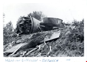
- Photograph of the aftermath of a train wreck that took place in the North Road cut due to a head-on collision between Canadian National Railway (CNR) and Great Northern Railway (GNR) trains.
- Repository
- City of Burnaby Archives
- Date
- July 1941
- Collection/Fonds
- Gordon McDonald collection
- Physical Description
- 1 photograph : b&w ; 8 x 11.5 cm
- Description Level
- Item
- Record No.
- 542-001
- Access Restriction
- No restrictions
- Reproduction Restriction
- No known restrictions
- Accession Number
- 2012-23
- Scope and Content
- Photograph of the aftermath of a train wreck that took place in the North Road cut due to a head-on collision between Canadian National Railway (CNR) and Great Northern Railway (GNR) trains.
- Subjects
- Accidents - Train Accidents
- Media Type
- Photograph
- Notes
- Title based on contents of photograph
- Note in pen on border (recto) of photograph reads: "Head-On Collision - Between - "
Images
Train wreck
https://search.heritageburnaby.ca/link/archivedescription74185
- Repository
- City of Burnaby Archives
- Date
- July 1941
- Collection/Fonds
- Gordon McDonald collection
- Description Level
- Item
- Physical Description
- 1 photograph : b&w ; 8 x 11.5 cm
- Scope and Content
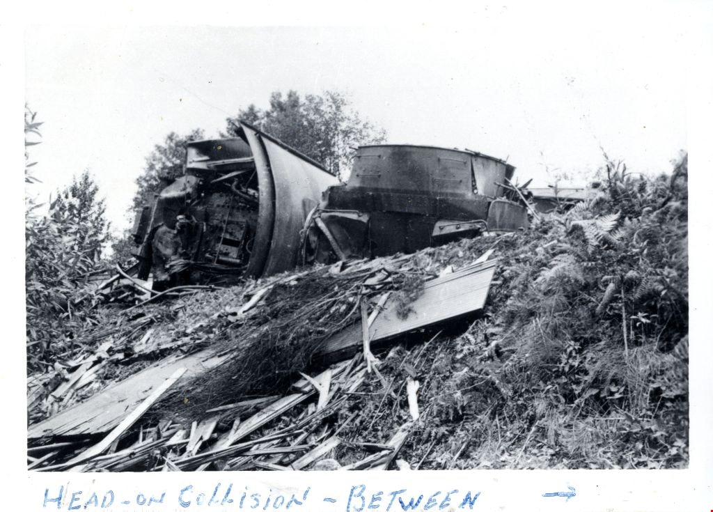
- Photograph of the aftermath of a train wreck that took place in the North Road cut due to a head-on collision between Canadian National Railway (CNR) and Great Northern Railway (GNR) trains.
- Repository
- City of Burnaby Archives
- Date
- July 1941
- Collection/Fonds
- Gordon McDonald collection
- Physical Description
- 1 photograph : b&w ; 8 x 11.5 cm
- Description Level
- Item
- Record No.
- 542-002
- Access Restriction
- No restrictions
- Reproduction Restriction
- No known restrictions
- Accession Number
- 2012-23
- Scope and Content
- Photograph of the aftermath of a train wreck that took place in the North Road cut due to a head-on collision between Canadian National Railway (CNR) and Great Northern Railway (GNR) trains.
- Subjects
- Accidents - Train Accidents
- Media Type
- Photograph
- Notes
- Title based on contents of photograph
- Note in pen on border (recto) of photograph reads: "CNR + GNR - July [?]4, 41"
Images
Train wreck
https://search.heritageburnaby.ca/link/archivedescription74186
- Repository
- City of Burnaby Archives
- Date
- July 1941
- Collection/Fonds
- Gordon McDonald collection
- Description Level
- Item
- Physical Description
- 1 photograph : b&w ; 8 x 11.5 cm
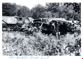
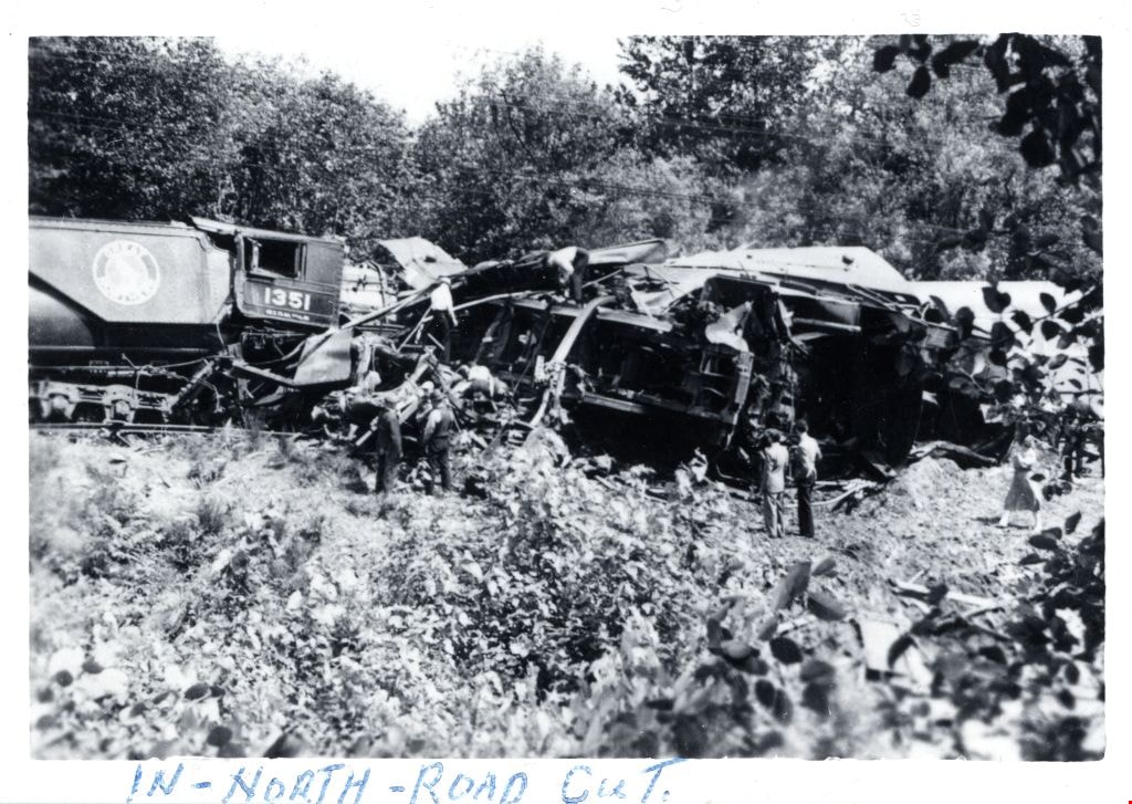
- Scope and Content
- Photograph of a group of people viewing the aftermath of a train wreck that took place in the North Road cut due to a head-on collision between Canadian National Railway (CNR) and Great Northern Railway (GNR) trains.
- Repository
- City of Burnaby Archives
- Date
- July 1941
- Collection/Fonds
- Gordon McDonald collection
- Physical Description
- 1 photograph : b&w ; 8 x 11.5 cm
- Description Level
- Item
- Record No.
- 542-003
- Access Restriction
- No restrictions
- Reproduction Restriction
- No known restrictions
- Accession Number
- 2012-23
- Scope and Content
- Photograph of a group of people viewing the aftermath of a train wreck that took place in the North Road cut due to a head-on collision between Canadian National Railway (CNR) and Great Northern Railway (GNR) trains.
- Subjects
- Accidents - Train Accidents
- Media Type
- Photograph
- Notes
- Title based on contents of photograph
- Note in pen on border (recto) of photograph reads: "In - North - Road Cut."
Images
Train wreck
https://search.heritageburnaby.ca/link/archivedescription74187
- Repository
- City of Burnaby Archives
- Date
- July 1941
- Collection/Fonds
- Gordon McDonald collection
- Description Level
- Item
- Physical Description
- 1 photograph : b&w ; 8 x 11.5 cm
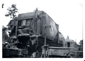
- Scope and Content
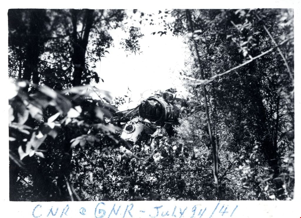
- Photograph of a Great Northern Railway train-car damaged from a train wreck that took place in the North Road cut. This was a head-on collision between Canadian National Railway (CNR) and Great Northern Railway (GNR) trains.
- Repository
- City of Burnaby Archives
- Date
- July 1941
- Collection/Fonds
- Gordon McDonald collection
- Physical Description
- 1 photograph : b&w ; 8 x 11.5 cm
- Description Level
- Item
- Record No.
- 542-004
- Access Restriction
- No restrictions
- Reproduction Restriction
- No known restrictions
- Accession Number
- 2012-23
- Scope and Content
- Photograph of a Great Northern Railway train-car damaged from a train wreck that took place in the North Road cut. This was a head-on collision between Canadian National Railway (CNR) and Great Northern Railway (GNR) trains.
- Subjects
- Accidents - Train Accidents
- Media Type
- Photograph
- Notes
- Title based on contents of photograph
Images

![Travelling freight train, [between 1930 and 1949] thumbnail](/media/hpo/_Data/_BVM_Images/1985/1985_6114_0090_001.jpg?width=280)
Travelling freight train
https://search.heritageburnaby.ca/link/museumdescription3317
- Repository
- Burnaby Village Museum
- Date
- [between 1930 and 1949]
- Collection/Fonds
- Burnaby Village Museum Photograph collection
- Description Level
- Item
- Physical Description
- 1 photograph : b&w ; 5.5 x 8 cm
- Scope and Content
- Photograph of a Seattle bound Great Northern Railway freight train travelling along the tracks and blowing smoke.
- Repository
- Burnaby Village Museum
- Collection/Fonds
- Burnaby Village Museum Photograph collection
- Description Level
- Item
- Physical Description
- 1 photograph : b&w ; 5.5 x 8 cm
- Scope and Content
- Photograph of a Seattle bound Great Northern Railway freight train travelling along the tracks and blowing smoke.
- Subjects
- Transportation - Rail
- Names
- Great Northern Railway
- Accession Code
- BV985.6114.90
- Access Restriction
- No restrictions
- Reproduction Restriction
- No known restrictions
- Date
- [between 1930 and 1949]
- Media Type
- Photograph
- Scan Resolution
- 600
- Scan Date
- 2024-03-26
- Notes
- Title based on contents of photograph
- Handwritten note in black ball-point pen on verso of photograph reads: "G.N. Freight Seattle Bound"
Images
![Travelling freight train, [between 1930 and 1949] thumbnail](/media/hpo/_Data/_BVM_Images/1985/1985_6114_0090_001.jpg)
![Wrecked rail cars, [May 1913] thumbnail](/media/hpo/_Data/_BVM_Images/1977/197900540001.jpg?width=280)
Wrecked rail cars
https://search.heritageburnaby.ca/link/museumdescription1429
- Repository
- Burnaby Village Museum
- Date
- [May 1913]
- Collection/Fonds
- Burnaby Village Museum Photograph collection
- Description Level
- Item
- Physical Description
- 1 photograph : b&w ; 8.1 x 13.9 cm
- Scope and Content
- Photograph of several wrecked rail cars abandoned on the side of a railway. There is gravel, rocks and dirt in the foreground, beside the railway tracks and a forested area in the background. An annotation on the back of the photograph reads: "Wrecked cares - Dump #4 / G.N. reclamation work / Vanco…
- Repository
- Burnaby Village Museum
- Collection/Fonds
- Burnaby Village Museum Photograph collection
- Description Level
- Item
- Physical Description
- 1 photograph : b&w ; 8.1 x 13.9 cm
- Scope and Content
- Photograph of several wrecked rail cars abandoned on the side of a railway. There is gravel, rocks and dirt in the foreground, beside the railway tracks and a forested area in the background. An annotation on the back of the photograph reads: "Wrecked cares - Dump #4 / G.N. reclamation work / Vancouver, B.C. / May - 1913." The accession register speculates that the photograph may be of an accident on the Great Northern line at Sperling.
- Names
- Great Northern Railway
- Geographic Access
- Vancouver
- Accession Code
- HV979.54.1
- Access Restriction
- No restrictions
- Reproduction Restriction
- No known restrictions
- Date
- [May 1913]
- Media Type
- Photograph
- Scan Resolution
- 600
- Scan Date
- 2023-09-12
- Notes
- Title based on contents of photograph
Images
![Wrecked rail cars, [May 1913] thumbnail](/media/hpo/_Data/_BVM_Images/1977/197900540001.jpg)

Broadview Neighbourhood
https://search.heritageburnaby.ca/link/landmark750
- Repository
- Burnaby Heritage Planning
- Associated Dates
- 1905-1924
- Heritage Value
- Between 1905 and 1924, the Broadview neighbourhood in Burnaby was settled by almost 100 families who saw the advantage of living in an area that was served by two railway lines - the B.C. Electric Railway and the Great Northern Railway. Touted as being only a 20 minute car ride to the city centre, this neighbourhood expanded during the early 1920s with the promise of a new direct access road to the city being built by the Great Northern Railway company and new blocks being opened up on two government reserves adjoining it.
- Historic Neighbourhood
- Broadview (Historic Neighbourhood)
- Planning Study Area
- Cascade-Schou Area
Images


Lozells Neighbourhood
https://search.heritageburnaby.ca/link/landmark756
- Repository
- Burnaby Heritage Planning
- Associated Dates
- 1905-1924
- Heritage Value
- In 1906 C.T. Piper and Alfred Wiggs built a sawmill at the foot of what is now Piper Avenue along the north shore of Burnaby Lake. These operations and the proximity of the Great Northern Railway encourage settlers to move into this area and among them were Colonel and Mrs. James Ward. They were authorized to open a post office here and Mrs. Ward named it 'Lozells' after the Anglican parish to which she had been a member in Birmingham, England.
- Historic Neighbourhood
- Lozells (Historic Neighbourhood)
- Planning Study Area
- Government Road Area
Images


Pioneer tales of Burnaby
https://search.heritageburnaby.ca/link/museumlibrary5860
- Repository
- Burnaby Village Museum
- Collection
- Digital Reference Collection
- Reference Collection
- Material Type
- Book
- ISBN
- 096928280x
- Call Number
- 971.133 SON COPY 4
- Contributor
- Sone, Michael
- Place of Publication
- Burnaby, B.C.
- Publisher
- Corporation of the District of Burnaby
- Publication Date
- c1987
- Physical Description
- 495 p. : ill. ; 31 cm.
- Inscription
- "TR687 - Bryburgh" / handprinted in pencil on frontend page
- Library Subject (LOC)
- Pioneers--British Columbia--Burnaby
- Frontier and pioneer life
- Biography
- Object History
- Early Burnaby as recalled by the settlers themselves who arrived from every corner of the world between 1888 and 1930, some witnessing incorporation of the district in 1892, all seeking a better life for themselves and especially for their children, all helping transform the wilderness into the modern municipality of today.
- Notes
- "Editor Michael Sone".
- Includes index.
- 4 copies held: copy 4
Images

Digital Books
Follow that fire : the history of the Burnaby Fire Department
https://search.heritageburnaby.ca/link/museumlibrary5194
- Repository
- Burnaby Village Museum
- Collection
- Digital Reference Collection
- Material Type
- Book
- ISBN
- 0969282826
- Call Number
- 363.378 PEN COPY 3
- Place of Publication
- [Burnaby, B.C.]
- Publisher
- City of Burnaby
- Publication Date
- 1997
- Physical Description
- 160 p. : ill. (some col.), 2 maps, ports. (some col.) ; 29 cm.
- Library Subject (LOC)
- Fire departments
- Fire fighters
- Name Access
- Burnaby Fire Department
- Notes
- Maps on lining papers.
- 3 copies held: copy 3.
Digital Books
Deer Lake Park : heritage resource inventory
https://search.heritageburnaby.ca/link/museumlibrary5468
- Repository
- Burnaby Village Museum
- Author
- Wolf, Jim
- Publication Date
- c1998
- Call Number
- 971.133 WOL COPY 2
.
Although he first tried to settle in Langley in
the hope of cashing in on the Great Northern
Railway line, the company instead located in
Surrey and Hill chose to purchase land in the
sleepy hollow that was Deer Lake. His lot was
the location of the old Finlayson homestead on
Deer Lake Brook beside
- Repository
- Burnaby Village Museum
- Collection
- Reference Collection
- Digital Reference Collection
- Material Type
- Book
- ISBN
- 0969282834
- 9780969282839
- Call Number
- 971.133 WOL COPY 2
- Author
- Wolf, Jim
- Place of Publication
- Burnaby, B.C.
- Publisher
- City of Burnaby, Community Heritage Commission
- Publication Date
- c1998
- Physical Description
- 47 p. : ill. ; 28 cm.
- Library Subject (LOC)
- Deer Lake Park (Burnaby, B.C.)--History
- Historic buildings--British Columbia--Burnaby
- Burnaby (B.C.)--Buildings, structures, etc.
- Notes
- 2 copies held : copy 2.
Digital Books
![Survey and Subdivision plans in New Westminster District Group 2 - Surrey, Delta
, [1898-1910] thumbnail](/media/hpo/_Data/_BVM_Cartographic_Material/1977/1977_0093_0078_001.jpg?width=280)
Survey and Subdivision plans in New Westminster District Group 2 - Surrey, Delta
https://search.heritageburnaby.ca/link/museumdescription7047
- Repository
- Burnaby Village Museum
- Date
- [1898-1910]
- Collection/Fonds
- Burnaby Village Museum Map collection
- Description Level
- File
- Physical Description
- 10 plans : graphite and ink on paper and linen; various sizes mounted on 2 sides of cardboard 76 x 102 cm
- Scope and Content
- File consists of a large board with four plans in New Westminster District mounted on one side and six plans mounted on the other side. Side A: 1. Plan : black ink on paper with colour (no formal title). Plan covers area in New Westminster District, Group 2 situated along the south shore of the …
- Repository
- Burnaby Village Museum
- Collection/Fonds
- Burnaby Village Museum Map collection
- Description Level
- File
- Physical Description
- 10 plans : graphite and ink on paper and linen; various sizes mounted on 2 sides of cardboard 76 x 102 cm
- Material Details
- Scales vary
- Indexed number on tape on edge of board reads "78"
- Scope and Content
- File consists of a large board with four plans in New Westminster District mounted on one side and six plans mounted on the other side. Side A: 1. Plan : black ink on paper with colour (no formal title). Plan covers area in New Westminster District, Group 2 situated along the south shore of the Fraser River identified as "Indian Reserve / Turner 1868" situated in District Lot 1 between District Lot 2 identified as "Mohun's Line" and "Herring's Line" bordered by lots B and A. Includes note "see plan of subdivision of Lots 3 & 4 Gr. 2". (Geographic location: Surrey) 2. Plan : graphite on paper ; Title reads: "B5N R2W, Sec.26_Sec. 28 / Sec. 35_Sec.36". Plan covers a 60 acre parcel in Sec. 35 with Yale wagon road to the south. Scale: 6 chains = 1 inch (Geographic location: Surrey) 3. Plan : black ink on paper ; Title reads: "Survey for Proposed Highway in Indian Reserve Surrey". Plan covers area of land to the northwest of Lot 2 along the shore of the Fraser River and identfies route of proposed highway, proposed tramway as well at the Great Northern Railway and bridge. Scale: 2 chains = 1 inch 4. Plan : black ink on red lined graphing paper ; Title reads: "Sketch Plan Showing Section of Great Northern R. of W. at Point of Crossing of Proposed Ditch". Plan covers area of Lot 2 in New Westminster District, Group 2. (Surrey) Scale: 1 inch = 5 feet. (Geographic location: Surrey) Side B: 1. Plan : black ink on paper ; Title reads: "Plan of Subdivision of a Portion of Section 13, TP2, Surrey Municipality, New Westminster District, B.C.". Plan covers land bordered by Coast Meridian Road (to the east), Bose Road (to the south) and Pike Road (to the west). Surveyed for D.S. Bayners, Nov. 24, 1908. Scale: 5 chains= 1 inch 2. Plan : black ink on linen with colour ; Title reads: "Traverse of the Waterline in front of Lots 3 and 4, Group 2, New Westminster District with G.N. Railway Right of Way". Plan covers area along the southern shore of the Fraser River with a road crossing the Great Northern Railway and leading to a wharf. Scale: 100 feet = 1 inch (Geographic location: Surrey) 3. Plan : black ink on paper ; Title reads: "Survey of the South Boundary of Sec. 12, Township 2, New Westminster District". Plan covers area south of Bose Road and west of Coast Meridean Road and north of McClellen Road. Scale: 400 feet = 1 inch. Sec.12 (Geographic location: Surrey) 4. Plan : graphite on paper ; Title reads: "Plan of Subdivisioin of a part of S.E. 1/4 of Sec. 7, TP 8". Plan covers area of Section 7 in New Westminster District, Group 2, Township 8. Streets are identified running through lot including, Langley Ave., Robinson Ave, Melrose Ave., Hawthorne Ave., Broadway, Bond Ave., Mable Ave., Breene Ave. and McLelland Ave. and Clover Valley Road. Scale: 200 feet = 1 inch. Note in black ink reads: See Bd. 166 for blue print. (Geographic location: Surrey) 5. Plan : graphite on linen ; Title reads: "Sec.20, B5N R2W". Plan covers area north of Yale Road and is subdivided into parts identified as A, B, C, D, E, and unknown. (Geographic location: Surrey) 6. Plan : black ink and graphite on paper ; (no formal title) Plan covers lots surveyed along Ladner Road identified as A, B and Lots 13, 12 and 11. [Geographic location: Delta]
- Accession Code
- HV977.93.78
- Access Restriction
- No restrictions
- Reproduction Restriction
- No known restrictions
- Date
- [1898-1910]
- Media Type
- Cartographic Material
- Scan Resolution
- 600
- Scan Date
- 2023-06-26
- Notes
- Title based on contents of file
- Note re plans 1A & 3A: The sight of Brownsville was also the former site of the Qayqayt First Nation and one of the main summer villages of the Kwantlen and ʷməθkʷəy̓əm (Musqueam) peoples
- Scale is measured in chains and feet. (One chain equals 792 inches)
Zoomable Images
![Survey and Subdivision plans in New Westminster District Group 2 - Surrey, Delta
, [1898-1910] thumbnail](/media/hpo/_Data/_BVM_Cartographic_Material/1977/1977_0093_0078_003_seadragon/1977_0093_0078_003.jpg?w=280)
Survey and Subdivision plans in New Westminster District Group 2 - Surrey, Delta , [1898-1910]
Zoom into Image
![Adley Substation, [1920] (date of original), copied 1986 thumbnail](/media/hpo/_Data/_Archives_Images/_Unrestricted/126/158-002.jpg?width=280)
Adley Substation
https://search.heritageburnaby.ca/link/archivedescription34917
- Repository
- City of Burnaby Archives
- Date
- [1920] (date of original), copied 1986
- Collection/Fonds
- Burnaby Historical Society fonds
- Description Level
- Item
- Physical Description
- 1 photograph : b&w ; 8.8 x 12.5 cm print
- Scope and Content
- Photograph of the exterior of the Adley Substation, beside the Great Northern Railway tracks near Willingdon Avenue. Signs on the building read: "Western Canada Power Co. Ltd." and "Use Stave Lake Power."
- Repository
- City of Burnaby Archives
- Date
- [1920] (date of original), copied 1986
- Collection/Fonds
- Burnaby Historical Society fonds
- Subseries
- Photographs subseries
- Physical Description
- 1 photograph : b&w ; 8.8 x 12.5 cm print
- Description Level
- Item
- Record No.
- 158-002
- Access Restriction
- No restrictions
- Reproduction Restriction
- No known restrictions
- Accession Number
- BHS1986-08
- Scope and Content
- Photograph of the exterior of the Adley Substation, beside the Great Northern Railway tracks near Willingdon Avenue. Signs on the building read: "Western Canada Power Co. Ltd." and "Use Stave Lake Power."
- Subjects
- Buildings - Industrial - Powerhouses
- Media Type
- Photograph
- Notes
- Title based on contents of photograph
- Geographic Access
- Willingdon Avenue
Images
![Adley Substation, [1920] (date of original), copied 1986 thumbnail](/media/hpo/_Data/_Archives_Images/_Unrestricted/126/158-002.jpg)
Burnaby centennial anthology : stories of early Burnaby
https://search.heritageburnaby.ca/link/museumlibrary5472
- Repository
- Burnaby Village Museum
- Edition
- Rev. ed.
- Publication Date
- 1994
- Call Number
- 971.133 BUR COPY 3
- Repository
- Burnaby Village Museum
- Collection
- Digital Reference Collection
- Material Type
- Book
- ISBN
- 0969282826
- Call Number
- 971.133 BUR COPY 3
- Edition
- Rev. ed.
- Place of Publication
- Burnaby, B.C.
- Publisher
- City of Burnaby
- Publication Date
- 1994
- Physical Description
- 531 p. : ill. ; 28 cm.
- Library Subject (LOC)
- Burnaby (B.C.)--History
- Burnaby (B.C.)
- Biography
- Notes
- Includes index.
- 3 copies held: copy 3.