Narrow Results By
Subject
- Advertising Medium - Signs and Signboards 3
- Aerial Photographs 10
- Agriculture - Farms 1
- Animals - Dogs 4
- Buildings - Civic - Archives 1
- Buildings - Civic - Fire Halls 2
- Buildings - Commercial 7
- Buildings - Commercial - Offices 1
- Buildings - Commercial - Stores 4
- Buildings - Industrial 3
- Buildings - Industrial - Dairies 1
- Buildings - Industrial - Factories 4

Government Road
https://search.heritageburnaby.ca/link/archivedescription35567
- Repository
- City of Burnaby Archives
- Date
- 1912 (date of original), copied 1986
- Collection/Fonds
- Burnaby Historical Society fonds
- Description Level
- Item
- Physical Description
- 1 photograph : b&w ; 12.7 x 17.8 cm print
- Scope and Content
- Photograph looking east on Government Road from the Haddon family house. One of the men in the photo is Robert Haddon. The other two people are unidentified. Note the loose gravel roadway and the bridge over Eagle Creek.
- Repository
- City of Burnaby Archives
- Date
- 1912 (date of original), copied 1986
- Collection/Fonds
- Burnaby Historical Society fonds
- Subseries
- Pioneer Tales subseries
- Physical Description
- 1 photograph : b&w ; 12.7 x 17.8 cm print
- Description Level
- Item
- Record No.
- 204-425
- Access Restriction
- No restrictions
- Reproduction Restriction
- No known restrictions
- Accession Number
- BHS1988-03
- Scope and Content
- Photograph looking east on Government Road from the Haddon family house. One of the men in the photo is Robert Haddon. The other two people are unidentified. Note the loose gravel roadway and the bridge over Eagle Creek.
- Names
- Haddon, Robert
- Media Type
- Photograph
- Notes
- Title based on contents of photograph
- Geographic Access
- Eagle Creek
- Government Road
- Historic Neighbourhood
- Lozells (Historic Neighbourhood)
- Planning Study Area
- Government Road Area
Images


Government Road
https://search.heritageburnaby.ca/link/archivedescription35569
- Repository
- City of Burnaby Archives
- Date
- 1925 (date of original), copied 1986
- Collection/Fonds
- Burnaby Historical Society fonds
- Description Level
- Item
- Physical Description
- 1 photograph : b&w ; 12.7 x 17.8 cm print
- Scope and Content
- Photograph of Government Road in front of the Haddon family house at 7870 Government Road. Note the bushland and rough road surface.
- Repository
- City of Burnaby Archives
- Date
- 1925 (date of original), copied 1986
- Collection/Fonds
- Burnaby Historical Society fonds
- Subseries
- Pioneer Tales subseries
- Physical Description
- 1 photograph : b&w ; 12.7 x 17.8 cm print
- Description Level
- Item
- Record No.
- 204-427
- Access Restriction
- No restrictions
- Reproduction Restriction
- No known restrictions
- Accession Number
- BHS1988-03
- Scope and Content
- Photograph of Government Road in front of the Haddon family house at 7870 Government Road. Note the bushland and rough road surface.
- Subjects
- Geographic Features - Roads
- Media Type
- Photograph
- Notes
- Title based on contents of photograph
- Geographic Access
- Government Road
- Historic Neighbourhood
- Lozells (Historic Neighbourhood)
- Planning Study Area
- Government Road Area
Images

![Government Road property, [191-] (date of original), copied 1986 thumbnail](/media/hpo/_Data/_Archives_Images/_Unrestricted/204/204-689.jpg?width=280)
Government Road property
https://search.heritageburnaby.ca/link/archivedescription35830
- Repository
- City of Burnaby Archives
- Date
- [191-] (date of original), copied 1986
- Collection/Fonds
- Burnaby Historical Society fonds
- Description Level
- Item
- Physical Description
- 1 photograph : b&w ; 12.7 x 17.8 cm print
- Scope and Content
- Photograph of (left) James Ker (maternal grandfather), (right) Robert Haddon (father), and Gordon Haddon (son), cutting firewood from a large fallen fir with a Wee MacGregor chainsaw on their Hastings Mill property south of the family home on Government Road.
- Repository
- City of Burnaby Archives
- Date
- [191-] (date of original), copied 1986
- Collection/Fonds
- Burnaby Historical Society fonds
- Subseries
- Pioneer Tales subseries
- Physical Description
- 1 photograph : b&w ; 12.7 x 17.8 cm print
- Description Level
- Item
- Record No.
- 204-689
- Access Restriction
- No restrictions
- Reproduction Restriction
- No restrictions
- Accession Number
- BHS1988-03
- Scope and Content
- Photograph of (left) James Ker (maternal grandfather), (right) Robert Haddon (father), and Gordon Haddon (son), cutting firewood from a large fallen fir with a Wee MacGregor chainsaw on their Hastings Mill property south of the family home on Government Road.
- Subjects
- Land Clearing
- Plants - Trees
- Media Type
- Photograph
- Notes
- Title based on contents of photograph
- Geographic Access
- Government Road
- Historic Neighbourhood
- Lozells (Historic Neighbourhood)
- Planning Study Area
- Government Road Area
Images
![Government Road property, [191-] (date of original), copied 1986 thumbnail](/media/hpo/_Data/_Archives_Images/_Unrestricted/204/204-689.jpg)
![Group in front of Seaforth School, [1945] (date of original), copied [1996] thumbnail](/media/hpo/_Data/_Archives_Images/_Unrestricted/316/355-020.jpg?width=280)
Group in front of Seaforth School
https://search.heritageburnaby.ca/link/archivedescription39826
- Repository
- City of Burnaby Archives
- Date
- [1945] (date of original), copied [1996]
- Collection/Fonds
- Burnaby Historical Society fonds
- Description Level
- Item
- Physical Description
- 1 photograph : b&w ; 6.5 x 9 cm print
- Scope and Content
- Photograph of six children standing in front of the Seaforth School building with the school's caretaker, Mr. Bridges (at the back). None of the children have been identified.
- Repository
- City of Burnaby Archives
- Date
- [1945] (date of original), copied [1996]
- Collection/Fonds
- Burnaby Historical Society fonds
- Subseries
- Seaforth School subseries
- Physical Description
- 1 photograph : b&w ; 6.5 x 9 cm print
- Description Level
- Item
- Record No.
- 355-020
- Access Restriction
- No restrictions
- Reproduction Restriction
- No known restrictions
- Accession Number
- BHS1997-14
- Scope and Content
- Photograph of six children standing in front of the Seaforth School building with the school's caretaker, Mr. Bridges (at the back). None of the children have been identified.
- Names
- Seaforth School
- Media Type
- Photograph
- Notes
- Title based on contents of photograph
- Geographic Access
- Government Road
- Deer Lake Avenue
- Street Address
- 7881 Government Road
- 6501 Deer Lake Avenue
- Historic Neighbourhood
- Lozells (Historic Neighbourhood)
- Planning Study Area
- Government Road Area
Images
![Group in front of Seaforth School, [1945] (date of original), copied [1996] thumbnail](/media/hpo/_Data/_Archives_Images/_Unrestricted/316/355-020.jpg)
![Group in front of Seaforth School, [1945] (date of original), copied [1996] thumbnail](/media/hpo/_Data/_Archives_Images/_Unrestricted/316/355-021.jpg?width=280)
Group in front of Seaforth School
https://search.heritageburnaby.ca/link/archivedescription39827
- Repository
- City of Burnaby Archives
- Date
- [1945] (date of original), copied [1996]
- Collection/Fonds
- Burnaby Historical Society fonds
- Description Level
- Item
- Physical Description
- 1 photograph : b&w ; 6.5 x 9 cm print
- Scope and Content
- Photograph of six children standing in front of the Seaforth School building. None of the children have been identified.
- Repository
- City of Burnaby Archives
- Date
- [1945] (date of original), copied [1996]
- Collection/Fonds
- Burnaby Historical Society fonds
- Subseries
- Seaforth School subseries
- Physical Description
- 1 photograph : b&w ; 6.5 x 9 cm print
- Description Level
- Item
- Record No.
- 355-021
- Access Restriction
- No restrictions
- Reproduction Restriction
- No known restrictions
- Accession Number
- BHS1997-14
- Scope and Content
- Photograph of six children standing in front of the Seaforth School building. None of the children have been identified.
- Names
- Seaforth School
- Media Type
- Photograph
- Notes
- Title based on contents of photograph
- Geographic Access
- Government Road
- Deer Lake Avenue
- Street Address
- 7881 Government Road
- 6501 Deer Lake Avenue
- Historic Neighbourhood
- Lozells (Historic Neighbourhood)
- Planning Study Area
- Government Road Area
Images
![Group in front of Seaforth School, [1945] (date of original), copied [1996] thumbnail](/media/hpo/_Data/_Archives_Images/_Unrestricted/316/355-021.jpg)
![Group in front of Seaforth School, [1945] (date of original), copied [1996] thumbnail](/media/hpo/_Data/_Archives_Images/_Unrestricted/316/355-022.jpg?width=280)
Group in front of Seaforth School
https://search.heritageburnaby.ca/link/archivedescription39828
- Repository
- City of Burnaby Archives
- Date
- [1945] (date of original), copied [1996]
- Collection/Fonds
- Burnaby Historical Society fonds
- Description Level
- Item
- Physical Description
- 1 photograph : b&w ; 6.5 x 9 cm print
- Scope and Content
- Photograph of five children standing in front of the Seaforth School building. None of the children have been identified.
- Repository
- City of Burnaby Archives
- Date
- [1945] (date of original), copied [1996]
- Collection/Fonds
- Burnaby Historical Society fonds
- Subseries
- Seaforth School subseries
- Physical Description
- 1 photograph : b&w ; 6.5 x 9 cm print
- Description Level
- Item
- Record No.
- 355-022
- Access Restriction
- No restrictions
- Reproduction Restriction
- No known restrictions
- Accession Number
- BHS1997-14
- Scope and Content
- Photograph of five children standing in front of the Seaforth School building. None of the children have been identified.
- Names
- Seaforth School
- Media Type
- Photograph
- Notes
- Title based on contents of photograph
- Geographic Access
- Government Road
- Deer Lake Avenue
- Street Address
- 7881 Government Road
- 6501 Deer Lake Avenue
- Historic Neighbourhood
- Lozells (Historic Neighbourhood)
- Planning Study Area
- Government Road Area
Images
![Group in front of Seaforth School, [1945] (date of original), copied [1996] thumbnail](/media/hpo/_Data/_Archives_Images/_Unrestricted/316/355-022.jpg)

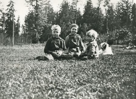
Haddon Family
https://search.heritageburnaby.ca/link/archivedescription35566
- Repository
- City of Burnaby Archives
- Date
- 1922 (date of original), copied 1986
- Collection/Fonds
- Burnaby Historical Society fonds
- Description Level
- Item
- Physical Description
- 1 photograph : b&w ; 12.7 x 17.8 cm print
- Scope and Content
- Photograph of Haddon family boys. Left to right: Gordon Haddon (brother), Jimmy Haddon (cousin), and Douglas Haddon (brother). This photo was taken looking south from behind the family home at 7870 Government Road between Lozells Avenue and Piper Avenue.
- Repository
- City of Burnaby Archives
- Date
- 1922 (date of original), copied 1986
- Collection/Fonds
- Burnaby Historical Society fonds
- Subseries
- Pioneer Tales subseries
- Physical Description
- 1 photograph : b&w ; 12.7 x 17.8 cm print
- Description Level
- Item
- Record No.
- 204-424
- Access Restriction
- No restrictions
- Reproduction Restriction
- No known restrictions
- Accession Number
- BHS1988-03
- Scope and Content
- Photograph of Haddon family boys. Left to right: Gordon Haddon (brother), Jimmy Haddon (cousin), and Douglas Haddon (brother). This photo was taken looking south from behind the family home at 7870 Government Road between Lozells Avenue and Piper Avenue.
- Subjects
- Animals - Dogs
- Media Type
- Photograph
- Notes
- Title based on contents of photograph
- Geographic Access
- Government Road
- Street Address
- 7870 Government Road
- Historic Neighbourhood
- Lozells (Historic Neighbourhood)
- Planning Study Area
- Government Road Area
Images

Haddon family
https://search.heritageburnaby.ca/link/archivedescription35568
- Repository
- City of Burnaby Archives
- Date
- 1925 (date of original), copied 1986
- Collection/Fonds
- Burnaby Historical Society fonds
- Description Level
- Item
- Physical Description
- 1 photograph : b&w ; 12.7 x 17.8 cm print
- Scope and Content
- Photograph of (left) Gordon Haddon and (right) Jimmy Haddon, his cousin, at Burnaby Lake where Eagle Creek flows into it. At the left is the dock at the foot of Piper Avenue. The water was deep and good for swimming.
- Repository
- City of Burnaby Archives
- Date
- 1925 (date of original), copied 1986
- Collection/Fonds
- Burnaby Historical Society fonds
- Subseries
- Pioneer Tales subseries
- Physical Description
- 1 photograph : b&w ; 12.7 x 17.8 cm print
- Description Level
- Item
- Record No.
- 204-426
- Access Restriction
- No restrictions
- Reproduction Restriction
- No known restrictions
- Accession Number
- BHS1988-03
- Scope and Content
- Photograph of (left) Gordon Haddon and (right) Jimmy Haddon, his cousin, at Burnaby Lake where Eagle Creek flows into it. At the left is the dock at the foot of Piper Avenue. The water was deep and good for swimming.
- Subjects
- Geographic Features - Lakes and Ponds
- Geographic Features - Creeks
- Structures - Piers and Wharves
- Sports - Swimming
- Names
- Haddon, Gordon
- Haddon, Jimmy
- Media Type
- Photograph
- Notes
- Title based on contents of photograph
- Geographic Access
- Burnaby Lake
- Piper Avenue
- Eagle Creek
- Historic Neighbourhood
- Lozells (Historic Neighbourhood)
- Planning Study Area
- Government Road Area
Images


Haddon family home
https://search.heritageburnaby.ca/link/archivedescription35564
- Repository
- City of Burnaby Archives
- Date
- 1919 (date of original), copied 1986
- Collection/Fonds
- Burnaby Historical Society fonds
- Description Level
- Item
- Physical Description
- 1 photograph : b&w ; 12.7 x 17.8 cm print
- Scope and Content
- Photograph of the Haddon family home at 7870 Government Road between Lozells Avenue and Piper Avenue. Three adults and a young child are standing in at the front door.
- Repository
- City of Burnaby Archives
- Date
- 1919 (date of original), copied 1986
- Collection/Fonds
- Burnaby Historical Society fonds
- Subseries
- Pioneer Tales subseries
- Physical Description
- 1 photograph : b&w ; 12.7 x 17.8 cm print
- Description Level
- Item
- Record No.
- 204-422
- Access Restriction
- No restrictions
- Reproduction Restriction
- No known restrictions
- Accession Number
- BHS1988-03
- Scope and Content
- Photograph of the Haddon family home at 7870 Government Road between Lozells Avenue and Piper Avenue. Three adults and a young child are standing in at the front door.
- Subjects
- Buildings - Residential - Houses
- Media Type
- Photograph
- Notes
- Title based on contents of photograph
- Geographic Access
- Government Road
- Street Address
- 7870 Government Road
- Historic Neighbourhood
- Lozells (Historic Neighbourhood)
- Planning Study Area
- Government Road Area
Images

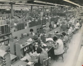
Interior of Lenkurt Electric Company
https://search.heritageburnaby.ca/link/archivedescription45616
- Repository
- City of Burnaby Archives
- Date
- November 1976, published November 17, 1976
- Collection/Fonds
- Columbian Newspaper collection
- Description Level
- Item
- Physical Description
- 1 photograph : b&w ; 19.5 x 24.5 cm
- Scope and Content
- Photograph of the interior of Lenkurt Electric's main manufacturing plant on the Lougheed Highway in Burnaby. Workers are at their desks, with their heads down, busily working. At the time of this photograph; "...1,400 employees make it one of the top secondary industries in B.C".
- Repository
- City of Burnaby Archives
- Date
- November 1976, published November 17, 1976
- Collection/Fonds
- Columbian Newspaper collection
- Physical Description
- 1 photograph : b&w ; 19.5 x 24.5 cm
- Description Level
- Item
- Record No.
- 480-510
- Access Restriction
- No restrictions
- Reproduction Restriction
- Reproduce for fair dealing purposes only
- Accession Number
- 2003-02
- Scope and Content
- Photograph of the interior of Lenkurt Electric's main manufacturing plant on the Lougheed Highway in Burnaby. Workers are at their desks, with their heads down, busily working. At the time of this photograph; "...1,400 employees make it one of the top secondary industries in B.C".
- Subjects
- Buildings - Industrial - Factories
- Names
- Lenkurt Electric Company
- Media Type
- Photograph
- Notes
- Title based on contents of photograph
- Newspaper clipping attached to verso of photograph reads: "Unit production at Lenkurt Electric's head office, research and development facility and main manufacturing plant on the Lougheed Highway in Burnaby is carried out on a semi-production basis, with a number of selected components mounted at each station. A total of 1,400 employees make it one of the top secondary industries in B.C."
- Geographic Access
- Lougheed Highway
- Street Address
- 7018 Lougheed Highway
- Historic Neighbourhood
- Lozells (Historic Neighbourhood)
- Planning Study Area
- Government Road Area
Images

![J.E. and Hephezebah Ward, [1912] (date of original) thumbnail](/media/hpo/_Data/_Archives_Images/_Unrestricted/251/312-001.jpg?width=280)
J.E. and Hephezebah Ward
https://search.heritageburnaby.ca/link/archivedescription36626
- Repository
- City of Burnaby Archives
- Date
- [1912] (date of original)
- Collection/Fonds
- Burnaby Historical Society fonds
- Description Level
- Item
- Physical Description
- 1 photograph : b&w ; 12.5 x 8.5 cm print
- Scope and Content
- Photograph of Lieutenant Colonel James E. Ward standing next to his wife Hephzebah, who is sitting in a wicker chair outside on the front porch. They look to be on the porch of the Lozells Post Office at the north eastern corner of the Great Northern tracks and Piper Road. In 1908 the couple came t…
- Repository
- City of Burnaby Archives
- Date
- [1912] (date of original)
- Collection/Fonds
- Burnaby Historical Society fonds
- Subseries
- Richard Hardy family subseries
- Physical Description
- 1 photograph : b&w ; 12.5 x 8.5 cm print
- Description Level
- Item
- Record No.
- 312-001
- Access Restriction
- No restrictions
- Reproduction Restriction
- No known restrictions
- Accession Number
- BHS1993-09
- Scope and Content
- Photograph of Lieutenant Colonel James E. Ward standing next to his wife Hephzebah, who is sitting in a wicker chair outside on the front porch. They look to be on the porch of the Lozells Post Office at the north eastern corner of the Great Northern tracks and Piper Road. In 1908 the couple came to Burnaby and opened the post office (naming it Lozells because when they lived in Birmingham England, Hepezebah was a parishioner in the Anglican Parish of Lozells).
- Media Type
- Photograph
- Notes
- Title based on contents of photograph
- Historic Neighbourhood
- Lozells (Historic Neighbourhood)
- Planning Study Area
- Government Road Area
Images
![J.E. and Hephezebah Ward, [1912] (date of original) thumbnail](/media/hpo/_Data/_Archives_Images/_Unrestricted/251/312-001.jpg)
![Karen and Blair Laramee with a puppet, [2000] thumbnail](/media/hpo/_Data/_Archives_Images/_Unrestricted/535/535-3075.jpg?width=280)
Karen and Blair Laramee with a puppet
https://search.heritageburnaby.ca/link/archivedescription97949
- Repository
- City of Burnaby Archives
- Date
- [2000]
- Collection/Fonds
- Burnaby NewsLeader photograph collection
- Description Level
- Item
- Physical Description
- 1 photograph (tiff) : col.
- Scope and Content
- Photograph of Karen and Blair Laramee, of Cliff Productions, repairing a 12-foot-tall puppet ahead of a presentation for "Weedless Wednesday," at Seaforth Elementary School.
- Repository
- City of Burnaby Archives
- Date
- [2000]
- Collection/Fonds
- Burnaby NewsLeader photograph collection
- Physical Description
- 1 photograph (tiff) : col.
- Description Level
- Item
- Record No.
- 535-3075
- Access Restriction
- No restrictions
- Reproduction Restriction
- No restrictions
- Accession Number
- 2018-12
- Scope and Content
- Photograph of Karen and Blair Laramee, of Cliff Productions, repairing a 12-foot-tall puppet ahead of a presentation for "Weedless Wednesday," at Seaforth Elementary School.
- Subjects
- Performances
- Performances - Dramatic Performances
- Recreational Activities - Theatre
- Occupations - Actors
- Names
- Seaforth School
- Media Type
- Photograph
- Photographer
- Bartel, Mario
- Notes
- Title based on caption
- Collected by editorial for use in a January 2000 issue of the Burnaby NewsLeader
- Caption from metadata: "Karen and Blair Laramee, of Cliff Productions, do some emergency repairs to one of their 12-foot tall rapping puppets before presenting a no-smoking message to students at Seaforth Elementary on Weedless Wednesday. One of the troupe's puppets was damaged when its head rolled out of their pickup truck onto the highway en route to the school."
- Geographic Access
- Government Road
- Street Address
- 7881 Government Road
- Historic Neighbourhood
- Lozells (Historic Neighbourhood)
- Planning Study Area
- Government Road Area
Images
![Karen and Blair Laramee with a puppet, [2000] thumbnail](/media/hpo/_Data/_Archives_Images/_Unrestricted/535/535-3075.jpg)

Lenkurt Electric
https://search.heritageburnaby.ca/link/archivedescription93626
- Repository
- City of Burnaby Archives
- Date
- October 23, 1977
- Collection/Fonds
- Burnaby Public Library Contemporary Visual Archive Project
- Description Level
- Item
- Physical Description
- 1 photograph : b&w ; 12.5 x 17.5 cm
- Scope and Content
- Photograph of the exterior of Lenkurt Electric, the telecommunications equipment manufacturing plant, on Lougheed Highway at Bainbridge Avenue. The photograph is taken facing south, from across the road.
- Repository
- City of Burnaby Archives
- Date
- October 23, 1977
- Collection/Fonds
- Burnaby Public Library Contemporary Visual Archive Project
- Physical Description
- 1 photograph : b&w ; 12.5 x 17.5 cm
- Description Level
- Item
- Record No.
- 556-583
- Access Restriction
- No restrictions
- Reproduction Restriction
- Reproduce for fair dealing purposes only
- Accession Number
- 2017-57
- Scope and Content
- Photograph of the exterior of Lenkurt Electric, the telecommunications equipment manufacturing plant, on Lougheed Highway at Bainbridge Avenue. The photograph is taken facing south, from across the road.
- Media Type
- Photograph
- Photographer
- Surridge, Jack
- Notes
- Title taken from project information form
- Accompanied by a project information form and 1 photograph (b&w negative ; 9.5 x 12.5 cm)
- BPL no. 30
- Geographic Access
- Lougheed Highway
- Bainbridge Avenue
- Street Address
- 7018 Lougheed Highway
- Historic Neighbourhood
- Lozells (Historic Neighbourhood)
- Planning Study Area
- Government Road Area
Images

![Lenkurt Electric Company, [1957] thumbnail](/media/Hpo/_Data/_Archives_Images/_Unrestricted/001/099-001.jpg?width=280)
Lenkurt Electric Company
https://search.heritageburnaby.ca/link/archivedescription34690
- Repository
- City of Burnaby Archives
- Date
- [1957]
- Collection/Fonds
- Burnaby Historical Society fonds
- Description Level
- Item
- Physical Description
- 1 photograph : b&w ; 20.3 x 25.3 cm
- Scope and Content
- Photograph of aerial view of the Lenkurt Electric Company at 6960 Lougheed Highway (later renumbered 7018 Lougheed Highway). A sign on the top of the building reads, "Lenkurt." An information sheet from the Company Relation Division of Lenkurt attached to the back of the photograph reads, "Aerial…
- Repository
- City of Burnaby Archives
- Date
- [1957]
- Collection/Fonds
- Burnaby Historical Society fonds
- Subseries
- Photographs subseries
- Physical Description
- 1 photograph : b&w ; 20.3 x 25.3 cm
- Description Level
- Item
- Record No.
- 099-001
- Access Restriction
- No restrictions
- Reproduction Restriction
- Reproduce for fair dealing purposes only
- Accession Number
- BHS2007-04
- Scope and Content
- Photograph of aerial view of the Lenkurt Electric Company at 6960 Lougheed Highway (later renumbered 7018 Lougheed Highway). A sign on the top of the building reads, "Lenkurt." An information sheet from the Company Relation Division of Lenkurt attached to the back of the photograph reads, "Aerial view of a 34,000 square foot building including a 19,000 square foot extension to the existing 15,000 square foot plant of Lenkurt Electric Co. of Canada Ltd. in North Burnaby, B.C., as at May 10th, 1957. / The building is situated on 20 acres of land and faces north onto Lougheed Highway."
- Names
- Lenkurt Electric Company
- Media Type
- Photograph
- Photographer
- Commercial Illustrators Industrial Photographers
- Notes
- Title based on contents of photograph
- Stamp and annotation on back of photograph reads, "TA. 8817 / Commerical Illustrators / Industrial Photographers / 601 Denman St., Vancouver 5, B.C. / File No. 1080-1"
- Geographic Access
- Lougheed Highway
- Street Address
- 7018 Lougheed Highway
- Historic Neighbourhood
- Lozells (Historic Neighbourhood)
- Planning Study Area
- Government Road Area
Images
![Lenkurt Electric Company, [1957] thumbnail](/media/Hpo/_Data/_Archives_Images/_Unrestricted/001/099-001.jpg)
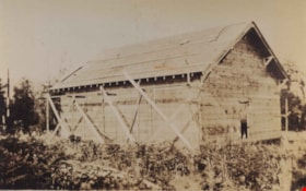
Lozells Community Hall near completion
https://search.heritageburnaby.ca/link/archivedescription36422
- Repository
- City of Burnaby Archives
- Date
- 1922
- Collection/Fonds
- Burnaby Historical Society fonds
- Description Level
- Item
- Physical Description
- 1 photograph : col. ; 7 x 11 cm print
- Scope and Content
- Photograph of the Lozells Community Hall near completion.
- Repository
- City of Burnaby Archives
- Date
- 1922
- Collection/Fonds
- Burnaby Historical Society fonds
- Subseries
- Photographs subseries
- Physical Description
- 1 photograph : col. ; 7 x 11 cm print
- Description Level
- Item
- Record No.
- 267-003
- Access Restriction
- No restrictions
- Reproduction Restriction
- No known restrictions
- Accession Number
- BHS1991-34
- Scope and Content
- Photograph of the Lozells Community Hall near completion.
- Media Type
- Photograph
- Notes
- Title based on contents of photograph
- Print is a colour copy of a sepia original
- Geographic Access
- Lozells Avenue
- Government Road
- Historic Neighbourhood
- Lozells (Historic Neighbourhood)
- Planning Study Area
- Government Road Area
Images

![Lozells Post Office in Burnaby, [between 1910 and 1913] thumbnail](/media/hpo/_Data/_BVM_Images/1975/1975_0032_0002_001.jpg?width=280)
Lozells Post Office in Burnaby
https://search.heritageburnaby.ca/link/museumdescription898
- Repository
- Burnaby Village Museum
- Date
- [between 1910 and 1913]
- Collection/Fonds
- Burnaby Village Museum Photograph collection
- Description Level
- Item
- Physical Description
- 1 photograph : b&w ; 8.2 x 13.7 cm
- Scope and Content
- Photograph of Lozells Post Office, on the north shore of Burnaby Lake. This two storey house stood at the north eastern corner of the Great Northern tracks and Piper Road. Around the house is a low picket fence, and a large sign that read, "LOZELLS." In 1908, Col. James Ward and his wife, Mrs. War…
- Repository
- Burnaby Village Museum
- Collection/Fonds
- Burnaby Village Museum Photograph collection
- Description Level
- Item
- Physical Description
- 1 photograph : b&w ; 8.2 x 13.7 cm
- Scope and Content
- Photograph of Lozells Post Office, on the north shore of Burnaby Lake. This two storey house stood at the north eastern corner of the Great Northern tracks and Piper Road. Around the house is a low picket fence, and a large sign that read, "LOZELLS." In 1908, Col. James Ward and his wife, Mrs. Ward, came to Lozells and opened a post office. Mrs. Ward named the place Lozells because when she lived in Birmingham England, she was a parishioner in the Anglican Parish of Lozells. (Reference: George Green's "History of Burnaby" p147).
- History
- Mrs. Lozells had lived in Birmingham, England, was a parishoner in the Anglican parish of Lozells in the city. The Graeat Northern Railway laid its tracks through this district [ ] and hwne this rail route was completed the Royal City Mills built a sawmill of considerable size near the foot of Piper Avenue. C.T.W. Pyper and Alfred Wiggs built a small mill nearby and a shipping siding was installed and called Pyper's Siding. (Reference from HIstory of Burnaby by George Green.)
- Subjects
- Buildings - Public - Post Offices
- Accession Code
- HV975.32.2
- Access Restriction
- No restrictions
- Reproduction Restriction
- No known restrictions
- Date
- [between 1910 and 1913]
- Media Type
- Photograph
- Historic Neighbourhood
- Lozells (Historic Neighbourhood)
- Planning Study Area
- Government Road Area
- Scan Resolution
- 600
- Scan Date
- 2023-06-06
- Notes
- Title based on contents of photograph
Images
![Lozells Post Office in Burnaby, [between 1910 and 1913] thumbnail](/media/hpo/_Data/_BVM_Images/1975/1975_0032_0002_001.jpg)
![Mr. and Mrs. Orville E. Butler, [193-] thumbnail](/media/hpo/_Data/_BVM_Images/1983/198300420005.jpg?width=280)
Mr. and Mrs. Orville E. Butler
https://search.heritageburnaby.ca/link/museumdescription284
- Repository
- Burnaby Village Museum
- Date
- [193-]
- Collection/Fonds
- Burnaby Village Museum Photograph collection
- Description Level
- Item
- Physical Description
- 1 photograph : b&w ; 9.7 x 14.9 cm
- Scope and Content
- Photograph of Mr. and Mrs. Orville E. Butler in front of their house. They are standing with an unidentified man in suit pants, shirt and a tie that is blowing in the wind. In the back, nearer the house, there is a table with tea cups arranged on it. Mr. Orville is wearing glasses, suspenders and a…
- Repository
- Burnaby Village Museum
- Collection/Fonds
- Burnaby Village Museum Photograph collection
- Description Level
- Item
- Physical Description
- 1 photograph : b&w ; 9.7 x 14.9 cm
- Scope and Content
- Photograph of Mr. and Mrs. Orville E. Butler in front of their house. They are standing with an unidentified man in suit pants, shirt and a tie that is blowing in the wind. In the back, nearer the house, there is a table with tea cups arranged on it. Mr. Orville is wearing glasses, suspenders and a pocket watch by his waist. The Butlers lived at 8006 Government Road.
- History
- Orval (or Orville) Elsworth Butler married Florena (or Floriana) Birdin 1928. He worked as a a cabinet maker and carpenter while she worked as a clerk until her marriage at age 44. Orval's first wife was named Catharine. Orval and Florena moved to Burnaby in the 1930s. Orval died at age 79 in 1941. Florena died in 1973 at age 90. Orval Butler likely built a house at 8006 Government Rd with his first wife, Catherine. Florena later lived in the house.
- Geographic Access
- Government Road
- Street Address
- 8006 Government Road
- Accession Code
- HV983.42.5
- Access Restriction
- No restrictions
- Reproduction Restriction
- No known restrictions
- Date
- [193-]
- Media Type
- Photograph
- Historic Neighbourhood
- Lozells (Historic Neighbourhood)
- Planning Study Area
- Government Road Area
- Scan Resolution
- 600
- Scan Date
- 2023-09-12
- Notes
- Title based on contents of photograph
- The accession register notes the house is located at 8006 Government Road (Address prior to 1959: 806 Government Road). A note in the accession file explains Mr. and Mrs. Butler built their own house on Government Road in 1930 or 1931.
Images
![Mr. and Mrs. Orville E. Butler, [193-] thumbnail](/media/hpo/_Data/_BVM_Images/1983/198300420005.jpg)

Old Seaforth School
https://search.heritageburnaby.ca/link/archivedescription93648
- Repository
- City of Burnaby Archives
- Date
- November 19, 1977
- Collection/Fonds
- Burnaby Public Library Contemporary Visual Archive Project
- Description Level
- Item
- Physical Description
- 1 photograph : b&w ; 12.5 x 17.5 cm
- Scope and Content
- Photograph of the rear exterior of two buildings of the old Seaforth School, before the original structure, built in 1922, moved to the Burnaby Village Museum in 1983. The school was located at 7881 Government Road. The photograph is taken facing northeast.
- Repository
- City of Burnaby Archives
- Date
- November 19, 1977
- Collection/Fonds
- Burnaby Public Library Contemporary Visual Archive Project
- Physical Description
- 1 photograph : b&w ; 12.5 x 17.5 cm
- Description Level
- Item
- Record No.
- 556-605
- Access Restriction
- No restrictions
- Reproduction Restriction
- Reproduce for fair dealing purposes only
- Accession Number
- 2017-57
- Scope and Content
- Photograph of the rear exterior of two buildings of the old Seaforth School, before the original structure, built in 1922, moved to the Burnaby Village Museum in 1983. The school was located at 7881 Government Road. The photograph is taken facing northeast.
- Subjects
- Buildings - Schools
- Names
- Seaforth School
- Media Type
- Photograph
- Photographer
- Surridge, Jack
- Notes
- Title taken from project information form
- Accompanied by a project information form and 1 photograph (b&w negative ; 9.5 x 12.5 cm)
- BPL no. 55
- Geographic Access
- Piper Avenue
- Government Road
- Street Address
- 7881 Government Road
- Historic Neighbourhood
- Lozells (Historic Neighbourhood)
- Planning Study Area
- Government Road Area
Images


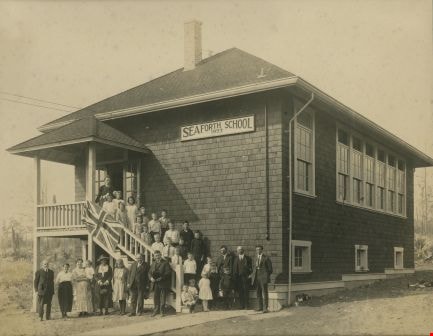
Opening day of Seaforth School in Burnaby
https://search.heritageburnaby.ca/link/archivedescription36608
- Repository
- City of Burnaby Archives
- Date
- 1922
- Collection/Fonds
- Burnaby Historical Society fonds
- Description Level
- Item
- Physical Description
- 1 photograph : sepia ; 18.5 x 23.5 cm (sight) in mat 30 x 35 cm
- Scope and Content
- Photograph of the official opening of Seaforth School on Government Road at Piper Avenue. Teachers, students, parents and staff are all standing on the steps of the school as well as in a long row out front. Individuals have been identified as; (from top of stairs) the school's first teacher Mrs. P…
- Repository
- City of Burnaby Archives
- Date
- 1922
- Collection/Fonds
- Burnaby Historical Society fonds
- Subseries
- J.P. Dickson subseries
- Physical Description
- 1 photograph : sepia ; 18.5 x 23.5 cm (sight) in mat 30 x 35 cm
- Description Level
- Item
- Record No.
- 308-001
- Access Restriction
- No restrictions
- Reproduction Restriction
- No known restrictions
- Accession Number
- BHS1992-51
- Scope and Content
- Photograph of the official opening of Seaforth School on Government Road at Piper Avenue. Teachers, students, parents and staff are all standing on the steps of the school as well as in a long row out front. Individuals have been identified as; (from top of stairs) the school's first teacher Mrs. Postill, (next step, left to right) [unidentified], Evelyn Jenkins, (next step) Dorothy Pipe, Myrtle Jackson, (next step) [unidentified], (next step) Beulah Tobaert, [unidentified], [unidentified], (next step) Madaleine Tobaert, Stewart Pipe, Arthur Haddon, (next step) [unidentified], [unidentified], Gordon Haddon, Russell Pipe, (next step) Jimmie Haddon, Douglas Haddon, George Johnston. Seated on the bottom steps are; unidentified and Douglas Haddon. Standing on the ground to the right of the seated boys are; (back row) [unidentified], [looks to be Claude Hill], [unidentified]. Standing in front of them are Kathleen Pipe, [unidentified] and Jack Jenkins. Standing on the ground to the left of the staircase are all unidentified except for the woman wearing a hat who has been identified as Mrs. Haddon (Myrtle and Jimmie's mom).The school building was later moved to Burnaby Village Museum.
- Subjects
- Occupations - Teachers
- Names
- Seaforth School
- Media Type
- Photograph
- Notes
- Title based on contents of photograph
- Item no. BV985.6022.2 is a laser copy of this original
- Individuals were identified from handwritten notes on recto of item BV985.6022.2 (laser copy of original)
- Geographic Access
- Government Road
- Deer Lake Avenue
- Street Address
- 7881 Government Road
- 6501 Deer Lake Avenue
- Historic Neighbourhood
- Lozells (Historic Neighbourhood)
- Planning Study Area
- Government Road Area
Images
![Orville E. Butler at his house, [193-] thumbnail](/media/hpo/_Data/_BVM_Images/1983/198300420006.jpg?width=280)
Orville E. Butler at his house
https://search.heritageburnaby.ca/link/museumdescription285
- Repository
- Burnaby Village Museum
- Date
- [193-]
- Collection/Fonds
- Burnaby Village Museum Photograph collection
- Description Level
- Item
- Physical Description
- 1 photograph : b&w ; 20.0 x 25.2 cm
- Scope and Content
- Photograph of the Butler family house at 8006 Government Road. On the lawn, Orville E. Butler and a young woman with a hat, possibly his daughter, are sitting on a bench, looking towards the photographer.
- Repository
- Burnaby Village Museum
- Collection/Fonds
- Burnaby Village Museum Photograph collection
- Description Level
- Item
- Physical Description
- 1 photograph : b&w ; 20.0 x 25.2 cm
- Scope and Content
- Photograph of the Butler family house at 8006 Government Road. On the lawn, Orville E. Butler and a young woman with a hat, possibly his daughter, are sitting on a bench, looking towards the photographer.
- Subjects
- Buildings - Residential - Houses
- Names
- Butler, Orville E.
- Geographic Access
- Government Road
- Street Address
- 8006 Government Road
- Accession Code
- HV983.42.6
- Access Restriction
- No restrictions
- Reproduction Restriction
- No known restrictions
- Date
- [193-]
- Media Type
- Photograph
- Historic Neighbourhood
- Lozells (Historic Neighbourhood)
- Planning Study Area
- Government Road Area
- Scan Resolution
- 600
- Scan Date
- 2023-09-12
- Notes
- Title based on contents of photograph
- 1 smaller b&w photograph accompanying
Images
![Orville E. Butler at his house, [193-] thumbnail](/media/hpo/_Data/_BVM_Images/1983/198300420006.jpg)