Narrow Results By
Subject
- Advertising Medium - Signs and Signboards 1
- Aerial Photographs 5
- Animals - Dogs 2
- Arts - Sculptures 1
- Buildings - Commercial - Bus Stations 1
- Buildings - Industrial - Refineries 1
- Buildings - Residential - Cabins 13
- Buildings - Residential - Houses 9
- Buildings - Schools - Universities and Colleges 2
- Clothing - Military Uniforms 2
- Documentary Artifacts - Postcards 1
- Geographic Features - Automobile Parking Lots 1

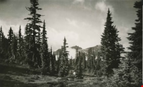
The Castle and Mount Frink
https://search.heritageburnaby.ca/link/archivedescription51446
- Repository
- City of Burnaby Archives
- Date
- 1938
- Collection/Fonds
- Burnaby Historical Society fonds
- Description Level
- Item
- Physical Description
- 1 photograph : b&w postcard ; 8 x 13 cm, mounted on heavy-weight paper 17.5 x 26.5 cm
- Scope and Content
- Photographic postcard of Moat Lake, with the two mountains known as the Castle (Castlecrag Mountain) and Mount Fink in the distance. This was part of a trip to the Forbidden Plateau on Vancouver Island made by a small party of City of Courtenay officials. George A. Grant was one of the climbers in …
- Repository
- City of Burnaby Archives
- Date
- 1938
- Collection/Fonds
- Burnaby Historical Society fonds
- Subseries
- George Grant subseries
- Physical Description
- 1 photograph : b&w postcard ; 8 x 13 cm, mounted on heavy-weight paper 17.5 x 26.5 cm
- Description Level
- Item
- Record No.
- 243-051
- Access Restriction
- No restrictions
- Reproduction Restriction
- No known restrictions
- Accession Number
- BHS1990-06
- Scope and Content
- Photographic postcard of Moat Lake, with the two mountains known as the Castle (Castlecrag Mountain) and Mount Fink in the distance. This was part of a trip to the Forbidden Plateau on Vancouver Island made by a small party of City of Courtenay officials. George A. Grant was one of the climbers in the party.
- Media Type
- Photograph
- Photographer
- Tait, Preston L.
- Notes
- Title taken from handwritten title on paper mount
- Handwritten note on facing page reads: "Where rose the mountains / There to him were friends / Byron"
- Photographer identifies photograph as no. 805
Images

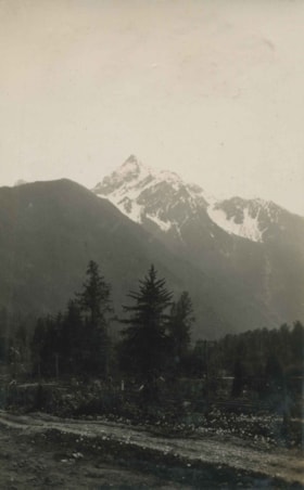
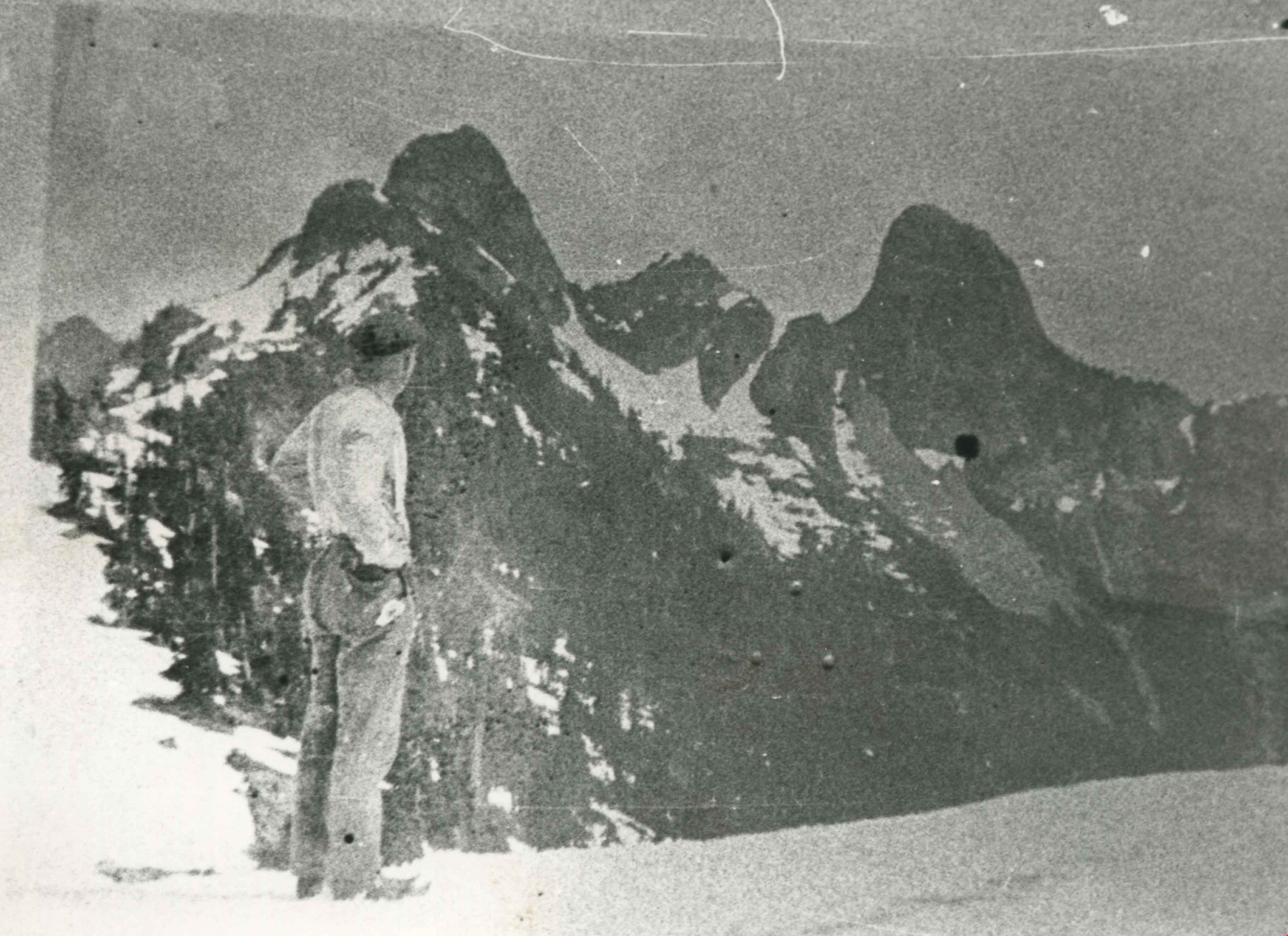
The Castle from the Meadows
https://search.heritageburnaby.ca/link/archivedescription51447
- Repository
- City of Burnaby Archives
- Date
- 1938
- Collection/Fonds
- Burnaby Historical Society fonds
- Description Level
- Item
- Physical Description
- 1 photograph : b&w postcard ; 8 x 12.5 cm, mounted on heavy-weight paper 17.5 x 26.5 cm
- Scope and Content
- Photographic postcard of the Castle (Castlecrag Mountain) and Mount Frink taken from the meadows. A man is standing at the edge of the tree line, looking towards the mountains. This was part of a trip to the Forbidden Plateau on Vancouver Island made by a small party of City of Courtenay officials.…
- Repository
- City of Burnaby Archives
- Date
- 1938
- Collection/Fonds
- Burnaby Historical Society fonds
- Subseries
- George Grant subseries
- Physical Description
- 1 photograph : b&w postcard ; 8 x 12.5 cm, mounted on heavy-weight paper 17.5 x 26.5 cm
- Description Level
- Item
- Record No.
- 243-052
- Access Restriction
- No restrictions
- Reproduction Restriction
- No known restrictions
- Accession Number
- BHS1990-06
- Scope and Content
- Photographic postcard of the Castle (Castlecrag Mountain) and Mount Frink taken from the meadows. A man is standing at the edge of the tree line, looking towards the mountains. This was part of a trip to the Forbidden Plateau on Vancouver Island made by a small party of City of Courtenay officials. George A. Grant was one of the climbers in the party.
- Media Type
- Photograph
- Notes
- Title taken from handwritten title on paper mount
- Handwritten note on on facing page reads: "A million years of the winds and the weather - / Still monarch of all I survey / Forbidden? Not to the lovers of heather / And the beauties of nature gay / So I welcome you to my lofty towers / My rock gardens, lakes and my streams / Come and walk among my beautiful flowers / And then see them always - in dreams. / And ever anon when far down below me / Loading lives of pleasure or care / Refreshing will be your most fond memory / Your Castle, way up in the air. / G.A.G."
Images

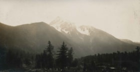
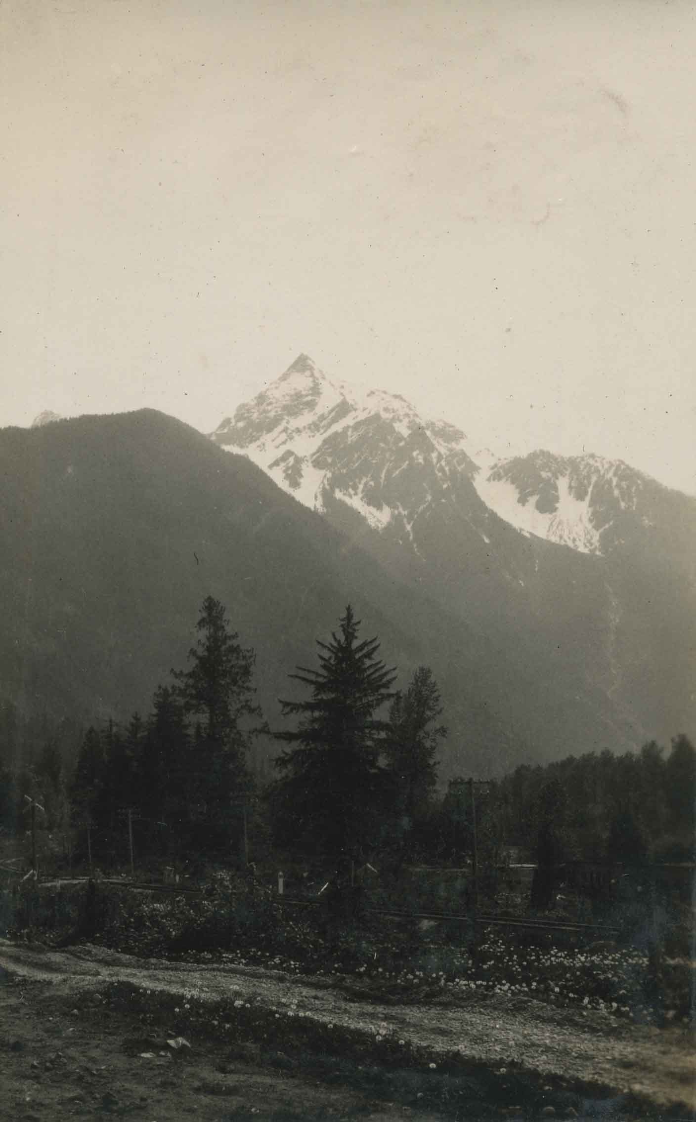
Cheam Peak
https://search.heritageburnaby.ca/link/archivedescription34382
- Repository
- City of Burnaby Archives
- Date
- 1926
- Collection/Fonds
- Burnaby Historical Society fonds
- Description Level
- Item
- Physical Description
- 1 photograph : b&w ; 6.1 x 11.5 cm on page 17.5 x 26.5 cm
- Scope and Content
- Photograph taken looking towards Cheam Peak, just east of Chilliwack. This photograph appears to have been taken by Arthur Peers, who travelled through the Fraser River Valley and worked on the construction of the Trans-Provincial Highway during the later 1920s.
- Repository
- City of Burnaby Archives
- Date
- 1926
- Collection/Fonds
- Burnaby Historical Society fonds
- Subseries
- Peers family subseries
- Physical Description
- 1 photograph : b&w ; 6.1 x 11.5 cm on page 17.5 x 26.5 cm
- Description Level
- Item
- Record No.
- 020-089
- Access Restriction
- No restrictions
- Reproduction Restriction
- No known restrictions
- Accession Number
- BHS2007-04
- Scope and Content
- Photograph taken looking towards Cheam Peak, just east of Chilliwack. This photograph appears to have been taken by Arthur Peers, who travelled through the Fraser River Valley and worked on the construction of the Trans-Provincial Highway during the later 1920s.
- Subjects
- Geographic Features - Mountains
- Media Type
- Photograph
- Photographer
- Peers, Arthur Francis "Mike"
- Notes
- Title based on caption accompanying photograph
Images

Cheam Peak
https://search.heritageburnaby.ca/link/archivedescription34384
- Repository
- City of Burnaby Archives
- Date
- 1926
- Collection/Fonds
- Burnaby Historical Society fonds
- Description Level
- Item
- Physical Description
- 1 photograph : b&w ; 6 x 9.2 cm on page 17.5 x 26.5 cm
- Scope and Content
- Photograph of Cheam Peak taken from a spot identified as Jones Hill. A road is seen running through the foreground. This photograph appears to have been taken by Arthur Peers, who travelled through the Fraser River Valley and worked on the construction of the Trans-Provincial Highway during the lat…
- Repository
- City of Burnaby Archives
- Date
- 1926
- Collection/Fonds
- Burnaby Historical Society fonds
- Subseries
- Peers family subseries
- Physical Description
- 1 photograph : b&w ; 6 x 9.2 cm on page 17.5 x 26.5 cm
- Description Level
- Item
- Record No.
- 020-091
- Access Restriction
- No restrictions
- Reproduction Restriction
- No known restrictions
- Accession Number
- BHS2007-04
- Scope and Content
- Photograph of Cheam Peak taken from a spot identified as Jones Hill. A road is seen running through the foreground. This photograph appears to have been taken by Arthur Peers, who travelled through the Fraser River Valley and worked on the construction of the Trans-Provincial Highway during the later 1920s.
- Subjects
- Geographic Features - Mountains
- Media Type
- Photograph
- Photographer
- Peers, Arthur Francis "Mike"
- Notes
- Title based on caption accompanying photograph
Images

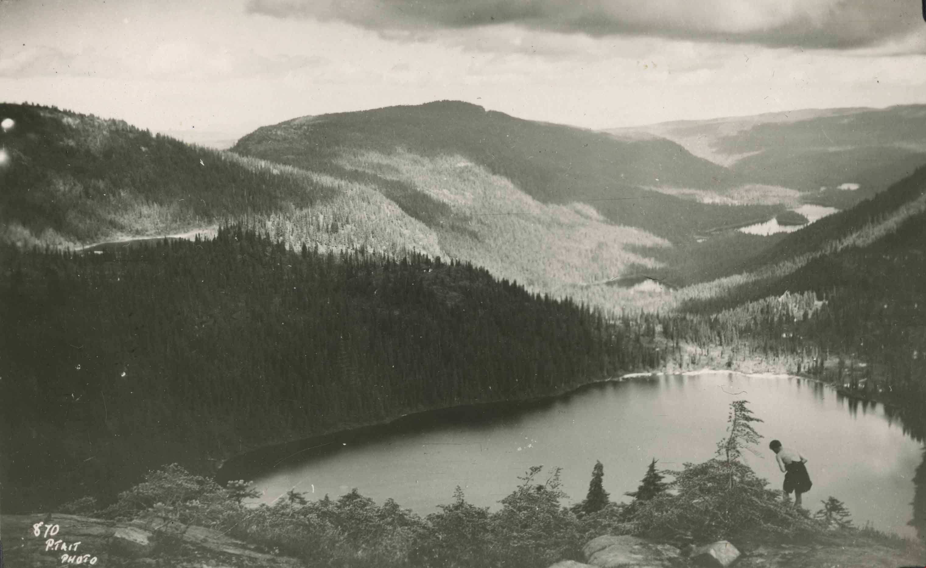
Circle Lake
https://search.heritageburnaby.ca/link/archivedescription51448
- Repository
- City of Burnaby Archives
- Date
- 1938
- Collection/Fonds
- Burnaby Historical Society fonds
- Description Level
- Item
- Physical Description
- 1 photograph : b&w postcard ; 8 x 13 cm, mounted on heavy-weight paper 17.5 x 26.5 cm
- Scope and Content
- Photographic postcard of Circle (Circlet) lake nestled among the mountains of the Forbidden Plateau on Vancouver Island, BC. A young man is making his way down Mount Albert Edward, towards the lake. This was part of a trip to the Forbidden Plateau made by a small party of City of Courtenay official…
- Repository
- City of Burnaby Archives
- Date
- 1938
- Collection/Fonds
- Burnaby Historical Society fonds
- Subseries
- George Grant subseries
- Physical Description
- 1 photograph : b&w postcard ; 8 x 13 cm, mounted on heavy-weight paper 17.5 x 26.5 cm
- Description Level
- Item
- Record No.
- 243-053
- Access Restriction
- No restrictions
- Reproduction Restriction
- No known restrictions
- Accession Number
- BHS1990-06
- Scope and Content
- Photographic postcard of Circle (Circlet) lake nestled among the mountains of the Forbidden Plateau on Vancouver Island, BC. A young man is making his way down Mount Albert Edward, towards the lake. This was part of a trip to the Forbidden Plateau made by a small party of City of Courtenay officials. George A. Grant was one of the climbers in the party.
- Subjects
- Geographic Features - Mountains
- Geographic Features - Lakes and Ponds
- Recreational Activities - Hiking
- Media Type
- Photograph
- Photographer
- Tait, Preston L.
- Notes
- Title taken from handwritten title on paper mount
- Handwritten note on on facing page reads: "Th' outstretching lake, embosomed' mong the hills / The eye with wonder and amazement fills / Burns"
- Photographer identifies photograph as no. 870
Images
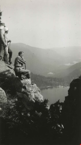
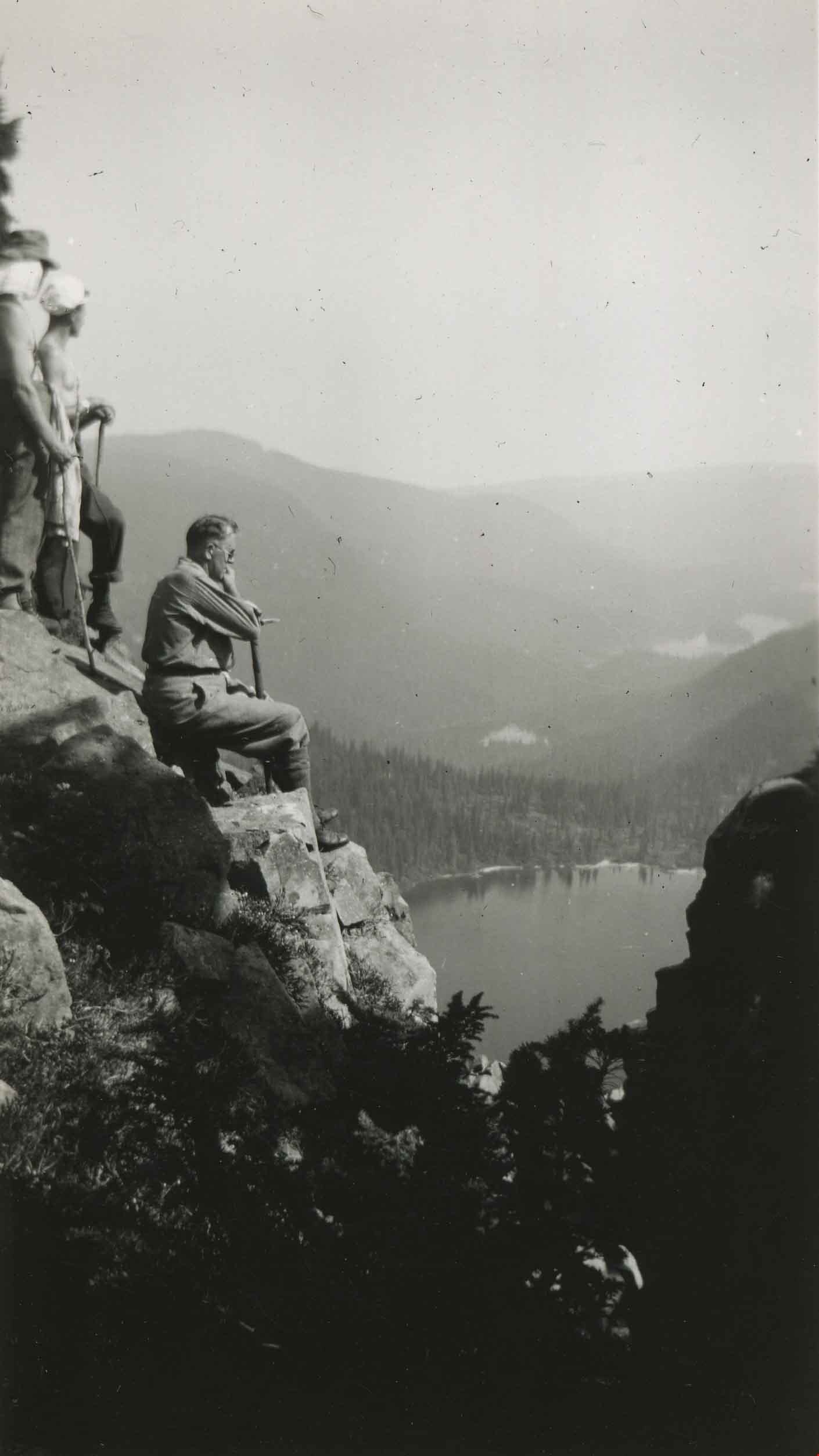
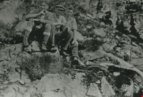
Contemplation
https://search.heritageburnaby.ca/link/archivedescription51449
- Repository
- City of Burnaby Archives
- Date
- August 19, 1938
- Collection/Fonds
- Burnaby Historical Society fonds
- Description Level
- Item
- Physical Description
- 1 photograph : b&w ; 10.5 x 6 cm, mounted on heavy-weight paper 17.5 x 26.5 cm
- Scope and Content
- Photograph of George A. Grant sitting on the rock face of Mount Albert Edward and admiring Circle (Circlet) Lake. Two men are standing just behind him. This was part of a trip to the Forbidden Plateau on Vancouver Island made by a small party of City of Courtenay officials.
- Repository
- City of Burnaby Archives
- Date
- August 19, 1938
- Collection/Fonds
- Burnaby Historical Society fonds
- Subseries
- George Grant subseries
- Physical Description
- 1 photograph : b&w ; 10.5 x 6 cm, mounted on heavy-weight paper 17.5 x 26.5 cm
- Description Level
- Item
- Record No.
- 243-054
- Access Restriction
- No restrictions
- Reproduction Restriction
- No known restrictions
- Accession Number
- BHS1990-06
- Scope and Content
- Photograph of George A. Grant sitting on the rock face of Mount Albert Edward and admiring Circle (Circlet) Lake. Two men are standing just behind him. This was part of a trip to the Forbidden Plateau on Vancouver Island made by a small party of City of Courtenay officials.
- Subjects
- Geographic Features - Mountains
- Geographic Features - Lakes and Ponds
- Recreational Activities - Hiking
- Media Type
- Photograph
- Notes
- Title taken from handwritten title on paper mount
- Handwritten note on facing page reads: "We pause on the Mount Abert [sic] Edward climb to admire Circle Lake and the rest."
- Stamp on verso of print reads: "Vancouver Drug Co. Ltd. AUG 19 1938 Nu-Gloss"
Images
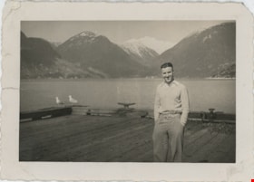
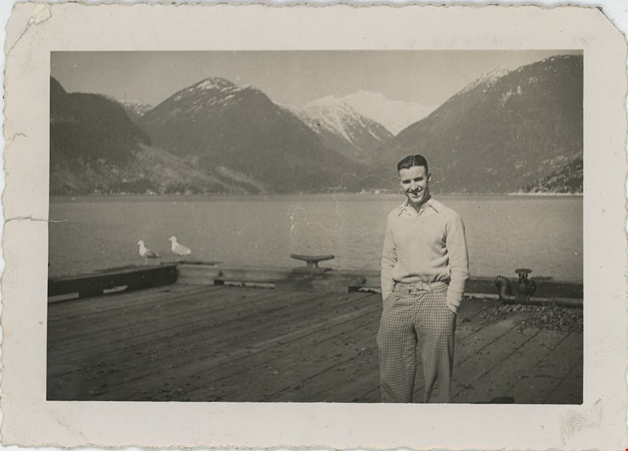
Crichton Hawkshaw standing on dock
https://search.heritageburnaby.ca/link/museumdescription19545
- Repository
- Burnaby Village Museum
- Date
- Apr. 1939
- Collection/Fonds
- Hawkshaw family fonds
- Description Level
- Item
- Physical Description
- 1 photograph : b&w ; 8.5 x 12 cm
- Scope and Content
- Photograph of Crichton Hawkshaw standing on a dock with view of mountains and Howe Sound behind him.
- Repository
- Burnaby Village Museum
- Collection/Fonds
- Hawkshaw family fonds
- Description Level
- Item
- Physical Description
- 1 photograph : b&w ; 8.5 x 12 cm
- Scope and Content
- Photograph of Crichton Hawkshaw standing on a dock with view of mountains and Howe Sound behind him.
- Subjects
- Geographic Features - Mountains
- Geographic Features - Natural Geographic Features
- Structures - Piers and Wharfs
- Accession Code
- BV996.6.252
- Access Restriction
- No restrictions
- Reproduction Restriction
- No known restrictions
- Date
- Apr. 1939
- Media Type
- Photograph
- Scan Date
- 2023-02-16
- Notes
- Title based on contents of photograph
- Caption beneath photograph reads: "April 1939"
- Photograph is part of photograph album BV996.6.1
Images
![Cross country skier on Mount Seymour, [between 1939 and 1949] (date of orignals), copied 2008 thumbnail](/media/hpo/_Data/_BVM_Images/2008/2008_0017_0022_001.jpg?width=280)
Cross country skier on Mount Seymour
https://search.heritageburnaby.ca/link/museumdescription2933
- Repository
- Burnaby Village Museum
- Date
- [between 1939 and 1949] (date of orignals), copied 2008
- Collection/Fonds
- Pixie McGeachie fonds
- Description Level
- Item
- Physical Description
- 1 photograph (tiff) : b&w ; 600 dpi
- Scope and Content
- Photograph of a snow covered ski trail and an unidentified cross-country skier on Mount Seymour, North Vancouver.
- Repository
- Burnaby Village Museum
- Collection/Fonds
- Pixie McGeachie fonds
- Description Level
- Item
- Physical Description
- 1 photograph (tiff) : b&w ; 600 dpi
- Scope and Content
- Photograph of a snow covered ski trail and an unidentified cross-country skier on Mount Seymour, North Vancouver.
- Subjects
- Natural Phenomena - Snow
- Geographic Features - Forests
- Geographic Features - Mountains - British Columbia
- Sports - Skiing
- Accession Code
- BV008.17.22
- Access Restriction
- No restrictions
- Reproduction Restriction
- May be restricted by third party rights
- Date
- [between 1939 and 1949] (date of orignals), copied 2008
- Media Type
- Photograph
- Notes
- Title based on contents of photograph
Images
![Cross country skier on Mount Seymour, [between 1939 and 1949] (date of orignals), copied 2008 thumbnail](/media/hpo/_Data/_BVM_Images/2008/2008_0017_0022_001.jpg)
Cultus Lake
https://search.heritageburnaby.ca/link/archivedescription34393
- Repository
- City of Burnaby Archives
- Date
- 1926
- Collection/Fonds
- Burnaby Historical Society fonds
- Description Level
- Item
- Physical Description
- 1 photograph : b&w ; 6.7 x 12 cm on page 17.4 x 26.4 cm
- Scope and Content
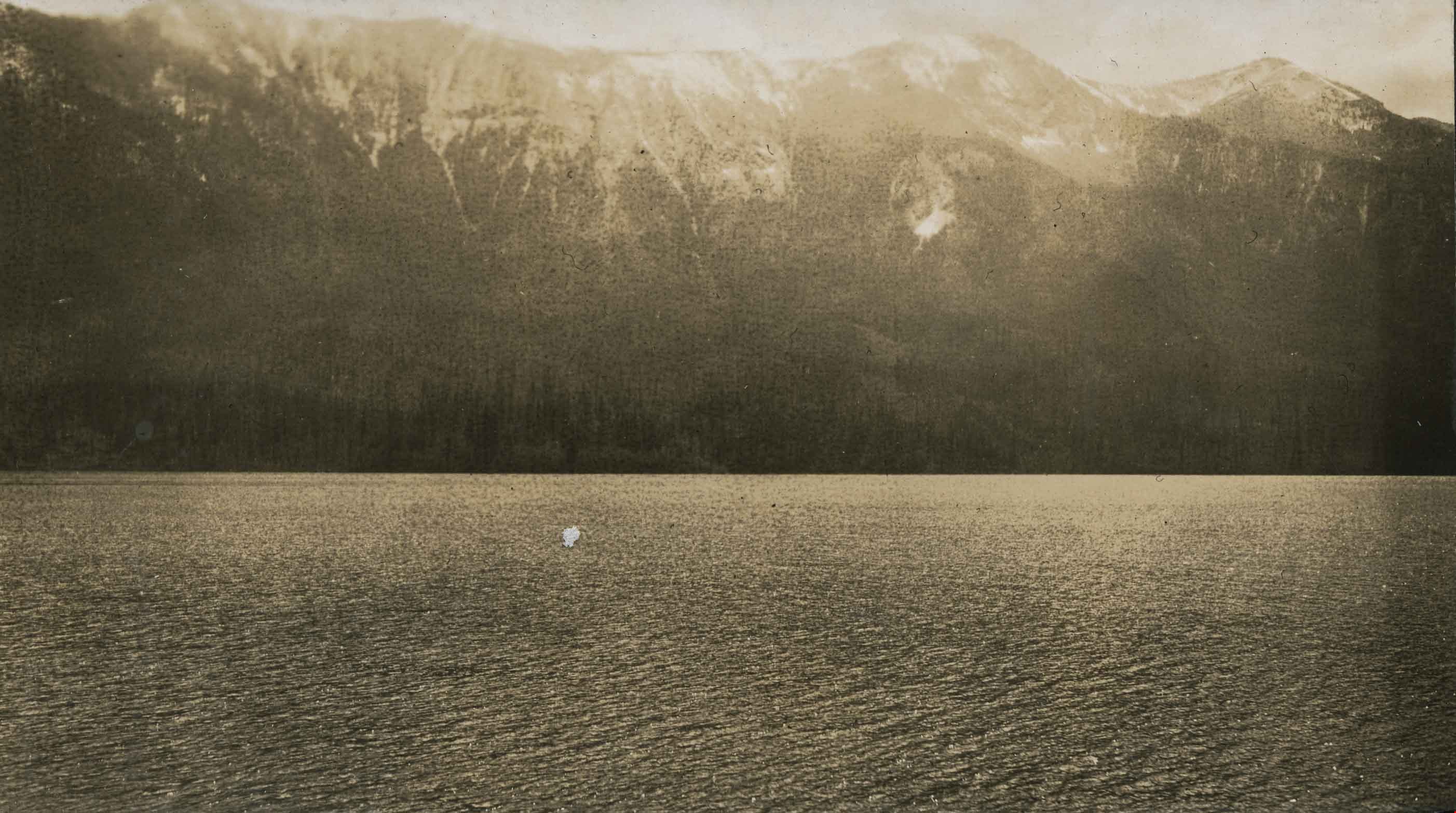
- Photograph taken looking over Cultus Lake towards the mountains. This photograph appears to have been taken by Arthur Peers, who travelled through the Fraser River Valley and worked on the construction of the Trans-Provincial Highway during the later 1920s.
- Repository
- City of Burnaby Archives
- Date
- 1926
- Collection/Fonds
- Burnaby Historical Society fonds
- Subseries
- Peers family subseries
- Physical Description
- 1 photograph : b&w ; 6.7 x 12 cm on page 17.4 x 26.4 cm
- Description Level
- Item
- Record No.
- 020-100
- Access Restriction
- No restrictions
- Reproduction Restriction
- No known restrictions
- Accession Number
- BHS2007-04
- Scope and Content
- Photograph taken looking over Cultus Lake towards the mountains. This photograph appears to have been taken by Arthur Peers, who travelled through the Fraser River Valley and worked on the construction of the Trans-Provincial Highway during the later 1920s.
- Media Type
- Photograph
- Photographer
- Peers, Arthur Francis "Mike"
- Notes
- Title based on caption accompanying photograph
Images

Cultus Lake
https://search.heritageburnaby.ca/link/archivedescription34396
- Repository
- City of Burnaby Archives
- Date
- 1926
- Collection/Fonds
- Burnaby Historical Society fonds
- Description Level
- Item
- Physical Description
- 1 photograph : b&w ; 7 x 12.2 cm on page 17.4 x 26.2 cm
- Scope and Content
- Photograph of Cultus Lake, looking towards the mountains. A wooden pier can be seen in the foreground and a row of cabins are visible on the far shore. This photograph appears to have been taken by Arthur Peers, who travelled through the Fraser River Valley and worked on the construction of the T…
- Repository
- City of Burnaby Archives
- Date
- 1926
- Collection/Fonds
- Burnaby Historical Society fonds
- Subseries
- Peers family subseries
- Physical Description
- 1 photograph : b&w ; 7 x 12.2 cm on page 17.4 x 26.2 cm
- Description Level
- Item
- Record No.
- 020-103
- Access Restriction
- No restrictions
- Reproduction Restriction
- No known restrictions
- Accession Number
- BHS2007-04
- Scope and Content
- Photograph of Cultus Lake, looking towards the mountains. A wooden pier can be seen in the foreground and a row of cabins are visible on the far shore. This photograph appears to have been taken by Arthur Peers, who travelled through the Fraser River Valley and worked on the construction of the Trans-Provincial Highway during the later 1920s.
- Subjects
- Geographic Features - Lakes and Ponds
- Structures - Piers and Wharves
- Geographic Features - Mountains
- Media Type
- Photograph
- Notes
- Title based on caption accompanying photograph
Images

Dave Gray
https://search.heritageburnaby.ca/link/archivedescription35692
- Repository
- City of Burnaby Archives
- Date
- May 1927 (date of original), copied 1986
- Collection/Fonds
- Burnaby Historical Society fonds
- Description Level
- Item
- Physical Description
- 1 photograph : b&w ; 12.7 x 17.8 cm print
- Scope and Content
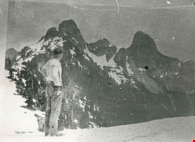
- Photograph of Dave Gray hiking toward the Lions (mountain peaks). Dave Gray, a famous baseball player and later teacher, was an all-round athlete who once taught Bob Wood. David Gray Park and swimming pool in South Burnaby were named after him.
- Repository
- City of Burnaby Archives
- Date
- May 1927 (date of original), copied 1986
- Collection/Fonds
- Burnaby Historical Society fonds
- Subseries
- Pioneer Tales subseries
- Physical Description
- 1 photograph : b&w ; 12.7 x 17.8 cm print
- Description Level
- Item
- Record No.
- 204-550
- Access Restriction
- No restrictions
- Reproduction Restriction
- No known restrictions
- Accession Number
- BHS1988-03
- Scope and Content
- Photograph of Dave Gray hiking toward the Lions (mountain peaks). Dave Gray, a famous baseball player and later teacher, was an all-round athlete who once taught Bob Wood. David Gray Park and swimming pool in South Burnaby were named after him.
- Names
- Gray, David "Dave"
- Media Type
- Photograph
- Notes
- Title based on contents of photograph
Images
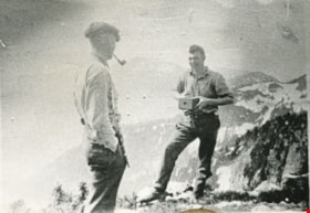
Dave Gray and Bob Wood
https://search.heritageburnaby.ca/link/archivedescription35693
- Repository
- City of Burnaby Archives
- Date
- May 1927 (date of original), copied 1986
- Collection/Fonds
- Burnaby Historical Society fonds
- Description Level
- Item
- Physical Description
- 1 photograph : b&w ; 12.7 x 17.8 cm print
- Scope and Content
- Photograph of Dave Gray and Bob Wood on a hike to the Lions peaks in West Vancouver. Dave Gray has his pipe clenched in his teeth, as Bob Wood points a box camera at him. The third member of hiking party, Art Hilton (not pictured), took this photograph. Dave Gray, a famous baseball player and late…
- Repository
- City of Burnaby Archives
- Date
- May 1927 (date of original), copied 1986
- Collection/Fonds
- Burnaby Historical Society fonds
- Subseries
- Pioneer Tales subseries
- Physical Description
- 1 photograph : b&w ; 12.7 x 17.8 cm print
- Description Level
- Item
- Record No.
- 204-551
- Access Restriction
- No restrictions
- Reproduction Restriction
- Reproduce for fair dealing purposes only
- Accession Number
- BHS1988-03
- Scope and Content
- Photograph of Dave Gray and Bob Wood on a hike to the Lions peaks in West Vancouver. Dave Gray has his pipe clenched in his teeth, as Bob Wood points a box camera at him. The third member of hiking party, Art Hilton (not pictured), took this photograph. Dave Gray, a famous baseball player and later teacher, was an all-round athlete who once taught Bob Wood. David Gray Park and swimming pool in South Burnaby were named after him.
- Media Type
- Photograph
- Photographer
- Hilton, Art
- Notes
- Title based on contents of photograph
Images

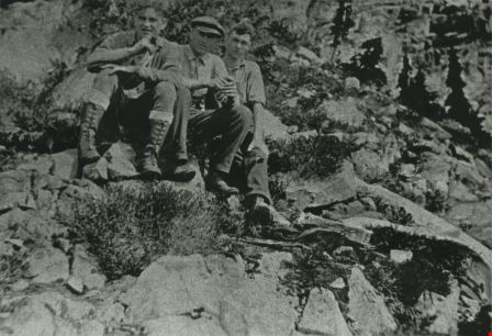
Dave Gray, Art Hilton and Bob Wood
https://search.heritageburnaby.ca/link/archivedescription35691
- Repository
- City of Burnaby Archives
- Date
- May 1927 (date of original), copied 1986
- Collection/Fonds
- Burnaby Historical Society fonds
- Description Level
- Item
- Physical Description
- 1 photograph : b&w ; 12.7 x 17.8 cm print
- Scope and Content
- Photograph of (left to right) Art Hilton (friend), Dave Gray (friend and father figure) and Bob Wood (friend) on a mountain hike in West Vancouver. Dave Gray, a famous baseball player and later teacher, was an all-round athlete who once taught Bob Wood. David Gray Park and swimming pool in South Bu…
- Repository
- City of Burnaby Archives
- Date
- May 1927 (date of original), copied 1986
- Collection/Fonds
- Burnaby Historical Society fonds
- Subseries
- Pioneer Tales subseries
- Physical Description
- 1 photograph : b&w ; 12.7 x 17.8 cm print
- Description Level
- Item
- Record No.
- 204-549
- Access Restriction
- No restrictions
- Reproduction Restriction
- No known restrictions
- Accession Number
- BHS1988-03
- Scope and Content
- Photograph of (left to right) Art Hilton (friend), Dave Gray (friend and father figure) and Bob Wood (friend) on a mountain hike in West Vancouver. Dave Gray, a famous baseball player and later teacher, was an all-round athlete who once taught Bob Wood. David Gray Park and swimming pool in South Burnaby were named after him.
- Media Type
- Photograph
- Notes
- Title based on contents of photograph
Images

Deer Lake
https://search.heritageburnaby.ca/link/archivedescription91707
- Repository
- City of Burnaby Archives
- Date
- 1994-1996
- Collection/Fonds
- Doreen Lawson fonds
- Description Level
- File
- Physical Description
- 55 photographs : col. slides ; 35 mm
- Scope and Content
- File consists of scenic photographs of Deer Lake and Deer Lake Park, including closeup photographs of the lake and landscape photographs with the lake in the foreground and mountains and skyline visible in the distance. The photographs capture Deer Lake in the fall, winter, and spring. Also inclu…
- Repository
- City of Burnaby Archives
- Date
- 1994-1996
- Collection/Fonds
- Doreen Lawson fonds
- Physical Description
- 55 photographs : col. slides ; 35 mm
- Description Level
- File
- Record No.
- 618-025
- Access Restriction
- No restrictions
- Reproduction Restriction
- No restrictions
- Accession Number
- 2015-15
- Scope and Content
- File consists of scenic photographs of Deer Lake and Deer Lake Park, including closeup photographs of the lake and landscape photographs with the lake in the foreground and mountains and skyline visible in the distance. The photographs capture Deer Lake in the fall, winter, and spring. Also included in the file are four photographs of Deer Lake Park signs.
- Subjects
- Natural Phenomena - Snow
- Geographic Features - Lakes and Ponds
- Plants - Trees
- Geographic Features - Mountains
- Advertising Medium - Signs and Signboards
- Names
- Burnaby Art Gallery
- Media Type
- Photograph
- Photographer
- Lawson, Doreen A.
- Notes
- Title based on contents of photographs
- Geographic Access
- Deer Lake
- Historic Neighbourhood
- Burnaby Lake (Historic Neighbourhood)
- Planning Study Area
- Oakalla Area
Images

![From 1855 18th Avenue, [1972 or 1973] (date of original), copied 1991 thumbnail](/media/hpo/_Data/_Archives_Images/_Unrestricted/370/370-262.jpg?width=280)
From 1855 18th Avenue
https://search.heritageburnaby.ca/link/archivedescription37674
- Repository
- City of Burnaby Archives
- Date
- [1972 or 1973] (date of original), copied 1991
- Collection/Fonds
- Burnaby Historical Society fonds
- Description Level
- Item
- Physical Description
- 1 photograph : b&w ; 3.8 x 3.8 cm print on contact sheet 20.2 x 25.3 cm
- Scope and Content
- Photograph taken from the back porch of 1855 18th Avenue (later renumbered as the 7000 block of 18th Avenue) looking west. Houses and mountains are visible.
- Repository
- City of Burnaby Archives
- Date
- [1972 or 1973] (date of original), copied 1991
- Collection/Fonds
- Burnaby Historical Society fonds
- Subseries
- Burnaby Image Bank subseries
- Physical Description
- 1 photograph : b&w ; 3.8 x 3.8 cm print on contact sheet 20.2 x 25.3 cm
- Description Level
- Item
- Record No.
- 370-262
- Access Restriction
- No restrictions
- Reproduction Restriction
- No restrictions
- Accession Number
- BHS1999-03
- Scope and Content
- Photograph taken from the back porch of 1855 18th Avenue (later renumbered as the 7000 block of 18th Avenue) looking west. Houses and mountains are visible.
- Media Type
- Photograph
- Notes
- Title based on contents of photograph
- 1 b&w copy negative accompanying
- Negative has a pink cast
- Copied from col. photograph
- Geographic Access
- 18th Avenue
- Historic Neighbourhood
- Edmonds (Historic Neighbourhood)
- Planning Study Area
- Stride Avenue Area
Images
![From 1855 18th Avenue, [1972 or 1973] (date of original), copied 1991 thumbnail](/media/hpo/_Data/_Archives_Images/_Unrestricted/370/370-262.jpg)
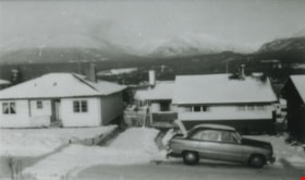
From 4042 Yale Street
https://search.heritageburnaby.ca/link/archivedescription37627
- Repository
- City of Burnaby Archives
- Date
- 1952 (date of original), copied 1991
- Collection/Fonds
- Burnaby Historical Society fonds
- Description Level
- Item
- Physical Description
- 1 photograph : b&w ; 2.8 x 4.8 cm print on contact sheet 20.2 x 25.3 cm
- Scope and Content
- Photograph taken looking north from 4042 Yale Street. The northshore mountains are visible in the background. There is snow.
- Repository
- City of Burnaby Archives
- Date
- 1952 (date of original), copied 1991
- Collection/Fonds
- Burnaby Historical Society fonds
- Subseries
- Burnaby Image Bank subseries
- Physical Description
- 1 photograph : b&w ; 2.8 x 4.8 cm print on contact sheet 20.2 x 25.3 cm
- Description Level
- Item
- Record No.
- 370-215
- Access Restriction
- No restrictions
- Reproduction Restriction
- No restrictions
- Accession Number
- BHS1999-03
- Scope and Content
- Photograph taken looking north from 4042 Yale Street. The northshore mountains are visible in the background. There is snow.
- Media Type
- Photograph
- Notes
- Title based on contents of photograph
- 1 b&w copy negative accompanying
- Geographic Access
- Yale Street
- Street Address
- 4042 Yale Street
- Historic Neighbourhood
- Vancouver Heights (Historic Neighbourhood)
- Planning Study Area
- Burnaby Heights Area
Images
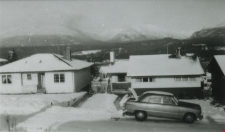

From 4042 Yale Street
https://search.heritageburnaby.ca/link/archivedescription37628
- Repository
- City of Burnaby Archives
- Date
- 1952 (date of original), copied 1991
- Collection/Fonds
- Burnaby Historical Society fonds
- Description Level
- Item
- Physical Description
- 1 photograph : b&w ; 2.9 x 4.8 cm print on contact sheet 20.2 x 25.3 cm
- Scope and Content
- Photograph taken looking north from 4042 Yale Street. Burrard Inlet and the northshore mountains are visible in the background, and there is snow.
- Repository
- City of Burnaby Archives
- Date
- 1952 (date of original), copied 1991
- Collection/Fonds
- Burnaby Historical Society fonds
- Subseries
- Burnaby Image Bank subseries
- Physical Description
- 1 photograph : b&w ; 2.9 x 4.8 cm print on contact sheet 20.2 x 25.3 cm
- Description Level
- Item
- Record No.
- 370-216
- Access Restriction
- No restrictions
- Reproduction Restriction
- No restrictions
- Accession Number
- BHS1999-03
- Scope and Content
- Photograph taken looking north from 4042 Yale Street. Burrard Inlet and the northshore mountains are visible in the background, and there is snow.
- Subjects
- Buildings - Residential - Houses
- Geographic Features - Inlets
- Geographic Features - Mountains
- Media Type
- Photograph
- Notes
- Title based on contents of photograph
- 1 b&w copy negative accompanying
- Geographic Access
- Yale Street
- Street Address
- 4042 Yale Street
- Historic Neighbourhood
- Vancouver Heights (Historic Neighbourhood)
- Planning Study Area
- Burnaby Heights Area
Images

![From Burnaby Mountain, [1947] (date of original), copied 1991 thumbnail](/media/hpo/_Data/_Archives_Images/_Unrestricted/370/370-502.jpg?width=280)
From Burnaby Mountain
https://search.heritageburnaby.ca/link/archivedescription37914
- Repository
- City of Burnaby Archives
- Date
- [1947] (date of original), copied 1991
- Collection/Fonds
- Burnaby Historical Society fonds
- Description Level
- Item
- Physical Description
- 1 photograph : b&w ; 2.5 x 3.9 cm print on contact sheet 20.2 x 26.3 cm
- Scope and Content
- Photograph taken from Burnaby Mountain, looking towards the Burrard Inlet.
- Repository
- City of Burnaby Archives
- Date
- [1947] (date of original), copied 1991
- Collection/Fonds
- Burnaby Historical Society fonds
- Subseries
- Burnaby Image Bank subseries
- Physical Description
- 1 photograph : b&w ; 2.5 x 3.9 cm print on contact sheet 20.2 x 26.3 cm
- Description Level
- Item
- Record No.
- 370-502
- Access Restriction
- No restrictions
- Reproduction Restriction
- No known restrictions
- Accession Number
- BHS1999-03
- Scope and Content
- Photograph taken from Burnaby Mountain, looking towards the Burrard Inlet.
- Media Type
- Photograph
- Notes
- Title based on contents of photograph
- 1 b&w copy negative accompanying
- Negative has a pink cast
- Geographic Access
- Burnaby Mountain Conservation Area
- Planning Study Area
- Burnaby Mountain Area
Images
![From Burnaby Mountain, [1947] (date of original), copied 1991 thumbnail](/media/hpo/_Data/_Archives_Images/_Unrestricted/370/370-502.jpg)
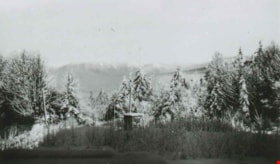
From George Derby Health Centre
https://search.heritageburnaby.ca/link/archivedescription37537
- Repository
- City of Burnaby Archives
- Date
- December 20, 1948 (date of original), copied 1991
- Collection/Fonds
- Burnaby Historical Society fonds
- Description Level
- Item
- Physical Description
- 1 photograph : b&w ; 2.9 x 5.0 cm print on contact sheet 20.2 x 25.3 cm
- Scope and Content
- Photograph taken from the George Derby Health Centre facing north. There is snow on the trees, no buildings are visible except for a small shack, and Burnaby Mountain can be seen in the background.
- Repository
- City of Burnaby Archives
- Date
- December 20, 1948 (date of original), copied 1991
- Collection/Fonds
- Burnaby Historical Society fonds
- Subseries
- Burnaby Image Bank subseries
- Physical Description
- 1 photograph : b&w ; 2.9 x 5.0 cm print on contact sheet 20.2 x 25.3 cm
- Description Level
- Item
- Record No.
- 370-125
- Access Restriction
- No restrictions
- Reproduction Restriction
- No known restrictions
- Accession Number
- BHS1999-03
- Scope and Content
- Photograph taken from the George Derby Health Centre facing north. There is snow on the trees, no buildings are visible except for a small shack, and Burnaby Mountain can be seen in the background.
- Subjects
- Geographic Features - Mountains
- Media Type
- Photograph
- Notes
- Title based on contents of photograph
- 1 b&w copy negative accompanying
- Geographic Access
- Cumberland Street
- Burnaby Mountain Conservation Area
- Street Address
- 7550 Cumberland Street
- Historic Neighbourhood
- East Burnaby (Historic Neighbourhood)
- Planning Study Area
- Cariboo-Armstrong Area
Images

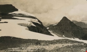
Getting towards the top of Mount Albert Edward
https://search.heritageburnaby.ca/link/archivedescription51457
- Repository
- City of Burnaby Archives
- Date
- 1938
- Collection/Fonds
- Burnaby Historical Society fonds
- Description Level
- Item
- Physical Description
- 1 photograph : sepia postcard ; 8 x 13 cm, mounted on heavy-weight paper 17.5 x 26.5 cm
- Scope and Content
- Photographic postcard of the summit of Mount Albert Edward. This was part of a trip to the Forbidden Plateau on Vancouver Islandn made by a small party of City of Courtenay officials. George A. Grant was one of the climbers in the party.
- Repository
- City of Burnaby Archives
- Date
- 1938
- Collection/Fonds
- Burnaby Historical Society fonds
- Subseries
- George Grant subseries
- Physical Description
- 1 photograph : sepia postcard ; 8 x 13 cm, mounted on heavy-weight paper 17.5 x 26.5 cm
- Description Level
- Item
- Record No.
- 243-062
- Access Restriction
- No restrictions
- Reproduction Restriction
- No known restrictions
- Accession Number
- BHS1990-06
- Scope and Content
- Photographic postcard of the summit of Mount Albert Edward. This was part of a trip to the Forbidden Plateau on Vancouver Islandn made by a small party of City of Courtenay officials. George A. Grant was one of the climbers in the party.
- Subjects
- Geographic Features - Mountains
- Media Type
- Photograph
- Photographer
- Robertson, J.
- Notes
- Handwritten note on paper mount reads: "Getting towards the top of Mount Albert Edward"
Images
