Narrow Results By
Subject
- Advertising Medium - Signs and Signboards 1
- Agricultural Tools and Equipment - Gardening Equipment 3
- Agriculture - Farms 2
- Animals - Deer 1
- Animals - Fowl 2
- Armament 1
- Buildings - Agricultural - Greenhouses 1
- Buildings - Commercial 5
- Buildings - Commercial - Hotels and Motels 1
- Buildings - Commercial - Train Stations 1
- Buildings - Heritage 1
- Buildings - Industrial - Refineries 1
![Herolz Path, [1918] (date of original), copied 1991 thumbnail](/media/hpo/_Data/_Archives_Images/_Unrestricted/370/370-566.jpg?width=280)
Herolz Path
https://search.heritageburnaby.ca/link/archivedescription37979
- Repository
- City of Burnaby Archives
- Date
- [1918] (date of original), copied 1991
- Collection/Fonds
- Burnaby Historical Society fonds
- Description Level
- Item
- Physical Description
- 1 photograph : b&w ; 3.7 x 2.6 cm print on contact sheet 20.7 x 26.2 cm
- Scope and Content
- Photograph of a path on the Herolz family property on Deer Lake Drive.
- Repository
- City of Burnaby Archives
- Date
- [1918] (date of original), copied 1991
- Collection/Fonds
- Burnaby Historical Society fonds
- Subseries
- Burnaby Image Bank subseries
- Physical Description
- 1 photograph : b&w ; 3.7 x 2.6 cm print on contact sheet 20.7 x 26.2 cm
- Description Level
- Item
- Record No.
- 370-566
- Access Restriction
- No restrictions
- Reproduction Restriction
- No known restrictions
- Accession Number
- BHS1999-03
- Scope and Content
- Photograph of a path on the Herolz family property on Deer Lake Drive.
- Subjects
- Geographic Features - Lanes
- Media Type
- Photograph
- Notes
- Title based on contents of photograph
- 1 b&w copy negative accompanying
- Geographic Access
- Deer Lake Drive
- Historic Neighbourhood
- Burnaby Lake (Historic Neighbourhood)
- Planning Study Area
- Morley-Buckingham Area
Images
![Herolz Path, [1918] (date of original), copied 1991 thumbnail](/media/hpo/_Data/_Archives_Images/_Unrestricted/370/370-566.jpg)
![Hill boys and friends, [1911] (date of original), copied 1986 thumbnail](/media/hpo/_Data/_Archives_Images/_Unrestricted/204/204-788.jpg?width=280)
Hill boys and friends
https://search.heritageburnaby.ca/link/archivedescription35928
- Repository
- City of Burnaby Archives
- Date
- [1911] (date of original), copied 1986
- Collection/Fonds
- Burnaby Historical Society fonds
- Description Level
- Item
- Physical Description
- 1 photograph : b&w ; 12.7 x 17.8 cm print
- Scope and Content
- Photograph of the Hill family boys and friends swimming in Deer Lake. Gerry Hill is seated cross-legged in front.
- Repository
- City of Burnaby Archives
- Date
- [1911] (date of original), copied 1986
- Collection/Fonds
- Burnaby Historical Society fonds
- Subseries
- Pioneer Tales subseries
- Physical Description
- 1 photograph : b&w ; 12.7 x 17.8 cm print
- Description Level
- Item
- Record No.
- 204-788
- Access Restriction
- No restrictions
- Reproduction Restriction
- No known restrictions
- Accession Number
- BHS1988-03
- Scope and Content
- Photograph of the Hill family boys and friends swimming in Deer Lake. Gerry Hill is seated cross-legged in front.
- Media Type
- Photograph
- Notes
- Title based on contents of photograph
- Geographic Access
- Deer Lake
- Deer Lake Avenue
- Historic Neighbourhood
- Burnaby Lake (Historic Neighbourhood)
- Planning Study Area
- Morley-Buckingham Area
Images
![Hill boys and friends, [1911] (date of original), copied 1986 thumbnail](/media/hpo/_Data/_Archives_Images/_Unrestricted/204/204-788.jpg)
![Holdom Avenue, [1912] (date of original), copied 1986 thumbnail](/media/hpo/_Data/_Archives_Images/_Unrestricted/204/204-700.jpg?width=280)
Holdom Avenue
https://search.heritageburnaby.ca/link/archivedescription35841
- Repository
- City of Burnaby Archives
- Date
- [1912] (date of original), copied 1986
- Collection/Fonds
- Burnaby Historical Society fonds
- Description Level
- Item
- Physical Description
- 1 photograph : b&w ; 12.7 x 17.8 cm print
- Scope and Content
- Photograph of Holdom Avenue when it was a logging skid road.
- Repository
- City of Burnaby Archives
- Date
- [1912] (date of original), copied 1986
- Collection/Fonds
- Burnaby Historical Society fonds
- Subseries
- Pioneer Tales subseries
- Physical Description
- 1 photograph : b&w ; 12.7 x 17.8 cm print
- Description Level
- Item
- Record No.
- 204-700
- Access Restriction
- No restrictions
- Reproduction Restriction
- No known restrictions
- Accession Number
- BHS1988-03
- Scope and Content
- Photograph of Holdom Avenue when it was a logging skid road.
- Subjects
- Geographic Features - Roads
- Media Type
- Photograph
- Photographer
- Phillips, James William "Jim"
- Notes
- Title based on contents of photograph
- Geographic Access
- Holdom Avenue
- Historic Neighbourhood
- Capitol Hill (Historic Neighbourhood)
- Planning Study Area
- Capitol Hill Area
Images
![Holdom Avenue, [1912] (date of original), copied 1986 thumbnail](/media/hpo/_Data/_Archives_Images/_Unrestricted/204/204-700.jpg)

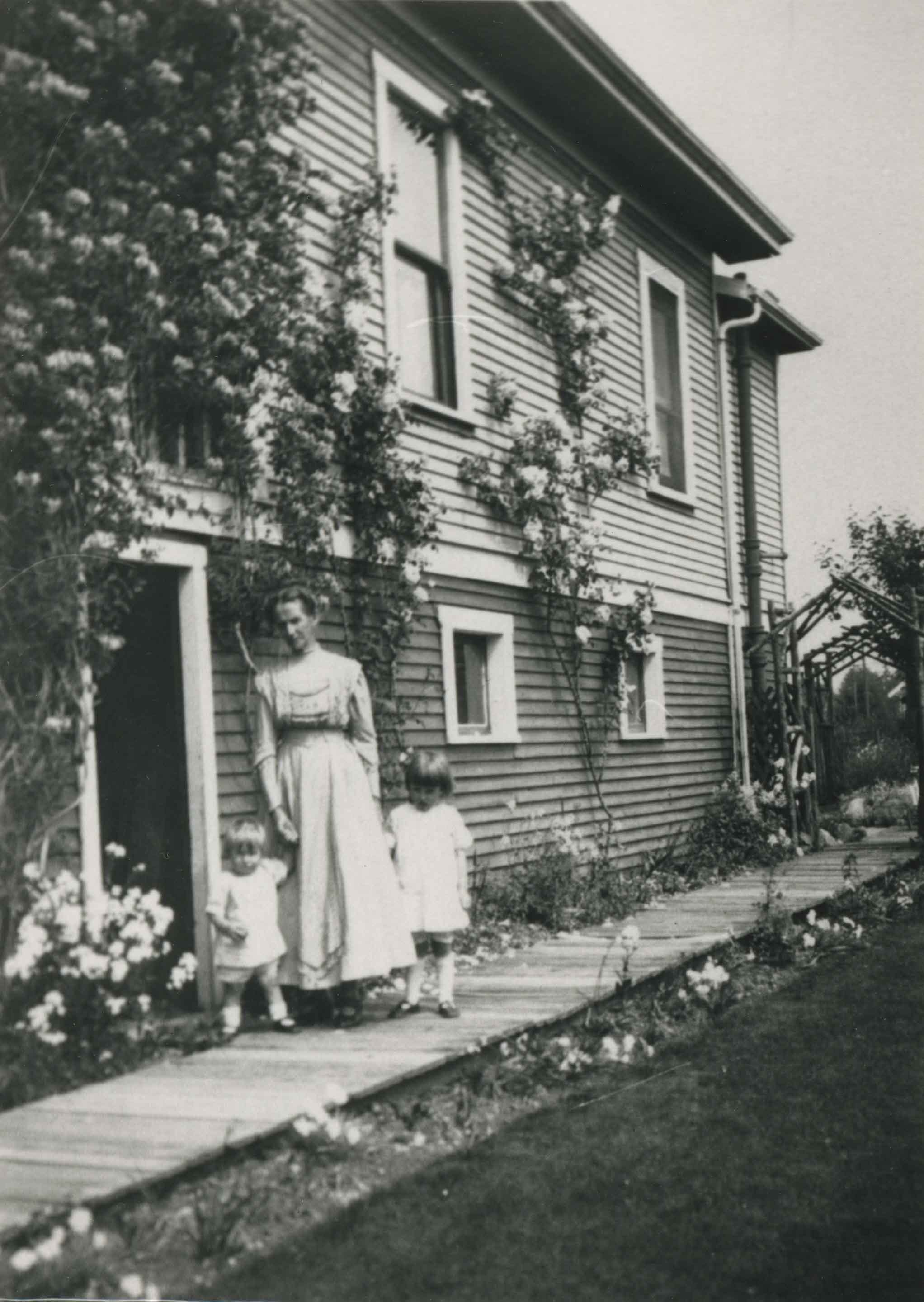
Hopper family
https://search.heritageburnaby.ca/link/archivedescription35081
- Repository
- City of Burnaby Archives
- Date
- 1912 (date of original), copied 1986
- Collection/Fonds
- Burnaby Historical Society fonds
- Description Level
- Item
- Physical Description
- 1 photograph : b&w ; 12.5 x 8.8 cm print
- Scope and Content
- Photograph of Mrs. Hopper and her grandchildren, Betty and Lois Atkinson, in the sideyard of a house on Kathleen Avenue. They are standing on a board sidewalk, and the flowers surrounding the house are in bloom.
- Repository
- City of Burnaby Archives
- Date
- 1912 (date of original), copied 1986
- Collection/Fonds
- Burnaby Historical Society fonds
- Subseries
- Davies family subseries
- Physical Description
- 1 photograph : b&w ; 12.5 x 8.8 cm print
- Description Level
- Item
- Record No.
- 190-001
- Access Restriction
- No restrictions
- Reproduction Restriction
- No known restrictions
- Accession Number
- BHS1986-41
- Scope and Content
- Photograph of Mrs. Hopper and her grandchildren, Betty and Lois Atkinson, in the sideyard of a house on Kathleen Avenue. They are standing on a board sidewalk, and the flowers surrounding the house are in bloom.
- Media Type
- Photograph
- Notes
- Title based on contents of photograph
- Geographic Access
- Kathleen Avenue
- Historic Neighbourhood
- Central Park (Historic Neighbourhood)
- Planning Study Area
- Maywood Area
Images
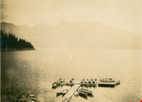
Horseshoe Bay
https://search.heritageburnaby.ca/link/museumdescription1068
- Repository
- Burnaby Village Museum
- Date
- 1910
- Collection/Fonds
- Burnaby Village Museum Photograph collection
- Description Level
- Item
- Physical Description
- 1 photograph : b&w ; 7.5 x 9.9 cm
- Scope and Content
- Photograph of Horeshoe Bay. There are fifteen rowing boats docked at a pier, and mountains are in the background. An annotation on the back of the photograph reads, "Horseshoe Bay / 1910."
- Repository
- Burnaby Village Museum
- Collection/Fonds
- Burnaby Village Museum Photograph collection
- Description Level
- Item
- Physical Description
- 1 photograph : b&w ; 7.5 x 9.9 cm
- Scope and Content
- Photograph of Horeshoe Bay. There are fifteen rowing boats docked at a pier, and mountains are in the background. An annotation on the back of the photograph reads, "Horseshoe Bay / 1910."
- Accession Code
- HV972.50.7
- Access Restriction
- No restrictions
- Reproduction Restriction
- No known restrictions
- Date
- 1910
- Media Type
- Photograph
- Scan Resolution
- 600
- Scan Date
- 2023-04-04
- Photographer
- Dean, H.M.
- Notes
- Title based on contents of photograph
Images
![Horseshoe Bay, [between 1908 and 1911] thumbnail](/media/hpo/_Data/_BVM_Images/1972/1972_0050_0012_001.jpg?width=280)
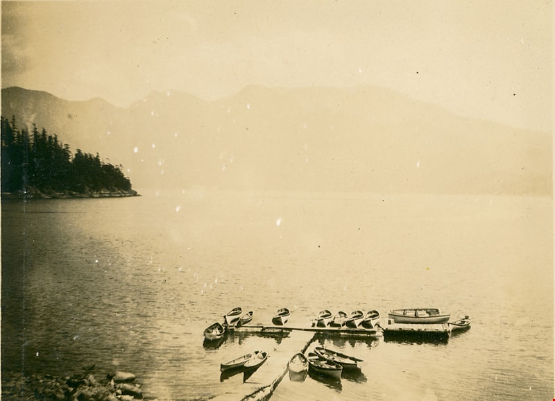
Horseshoe Bay
https://search.heritageburnaby.ca/link/museumdescription1073
- Repository
- Burnaby Village Museum
- Date
- [between 1908 and 1911]
- Collection/Fonds
- Burnaby Village Museum Photograph collection
- Description Level
- Item
- Physical Description
- 1 photograph : sepia ; 7.4 x 9.9 cm mounted on paper 13.6 x 18.3 cm
- Scope and Content
- Photograph of Horeshoe Bay. People are walking on the beach, swimming, and boating.
- Repository
- Burnaby Village Museum
- Collection/Fonds
- Burnaby Village Museum Photograph collection
- Description Level
- Item
- Physical Description
- 1 photograph : sepia ; 7.4 x 9.9 cm mounted on paper 13.6 x 18.3 cm
- Scope and Content
- Photograph of Horeshoe Bay. People are walking on the beach, swimming, and boating.
- Accession Code
- HV972.50.12
- Access Restriction
- No restrictions
- Reproduction Restriction
- No known restrictions
- Date
- [between 1908 and 1911]
- Media Type
- Photograph
- Scan Resolution
- 600
- Scan Date
- 2023-04-04
- Photographer
- Dean, H.M.
- Notes
- Title based on contents of photograph
Images
![Horseshoe Bay, [between 1908 and 1911] thumbnail](/media/hpo/_Data/_BVM_Images/1972/1972_0050_0012_001.jpg)
![Horseshoe Bay, [between 1908 and 1911] thumbnail](/media/hpo/_Data/_BVM_Images/1972/1972_0050_0013_001.jpg?width=280)
Horseshoe Bay
https://search.heritageburnaby.ca/link/museumdescription1074
- Repository
- Burnaby Village Museum
- Date
- [between 1908 and 1911]
- Collection/Fonds
- Burnaby Village Museum Photograph collection
- Description Level
- Item
- Physical Description
- 1 photograph : b&w ; 7.5 x 9.8 cm mounted on paper 13.6 x 18.3 cm
- Scope and Content
- Photograph of Horeshoe Bay. People are walking on the beach, swimming, and boating.
- Repository
- Burnaby Village Museum
- Collection/Fonds
- Burnaby Village Museum Photograph collection
- Description Level
- Item
- Physical Description
- 1 photograph : b&w ; 7.5 x 9.8 cm mounted on paper 13.6 x 18.3 cm
- Scope and Content
- Photograph of Horeshoe Bay. People are walking on the beach, swimming, and boating.
- Accession Code
- HV972.50.13
- Access Restriction
- No restrictions
- Reproduction Restriction
- No known restrictions
- Date
- [between 1908 and 1911]
- Media Type
- Photograph
- Scan Resolution
- 600
- Scan Date
- 2023-04-04
- Photographer
- Dean, H.M.
- Notes
- Title based on contents of photograph
Images
![Horseshoe Bay, [between 1908 and 1911] thumbnail](/media/hpo/_Data/_BVM_Images/1972/1972_0050_0013_001.jpg)
![In a Garden, [191-?] thumbnail](/media/hpo/_Data/_BVM_Images/1983/1983_0042_0088_001.jpg?width=280)
In a Garden
https://search.heritageburnaby.ca/link/museumdescription348
- Repository
- Burnaby Village Museum
- Date
- [191-?]
- Collection/Fonds
- Burnaby Village Museum Photograph collection
- Description Level
- Item
- Physical Description
- 1 photograph : b&w ; 8.8 x 14.4 cm
- Scope and Content
- Photograph of an unidentified group of two men and three women, standing together in a garden.The men are in suits and women in dresses. To the left of the photograph, there is an fruit tree (possibly orange), and to the right of the photograph, there is a wooden arbor, and flowers growing in front…
- Repository
- Burnaby Village Museum
- Collection/Fonds
- Burnaby Village Museum Photograph collection
- Description Level
- Item
- Physical Description
- 1 photograph : b&w ; 8.8 x 14.4 cm
- Scope and Content
- Photograph of an unidentified group of two men and three women, standing together in a garden.The men are in suits and women in dresses. To the left of the photograph, there is an fruit tree (possibly orange), and to the right of the photograph, there is a wooden arbor, and flowers growing in front of where the group is standing. The location is not identified.
- Subjects
- Geographic Features - Gardens
- Accession Code
- HV983.42.88
- Access Restriction
- No restrictions
- Reproduction Restriction
- No known restrictions
- Date
- [191-?]
- Media Type
- Photograph
- Scan Resolution
- 600
- Scan Date
- 2023-09-26
- Notes
- Title based on contents of photograph
Images
![In a Garden, [191-?] thumbnail](/media/hpo/_Data/_BVM_Images/1983/1983_0042_0088_001.jpg)
![Interior of British Columbia, [191-] thumbnail](/media/hpo/_Data/_BVM_Images/1987/1987_0049_0002_001.jpg?width=280)
Interior of British Columbia
https://search.heritageburnaby.ca/link/museumdescription140
- Repository
- Burnaby Village Museum
- Date
- [191-]
- Collection/Fonds
- Burnaby Village Museum Photograph collection
- Description Level
- Item
- Physical Description
- 1 photograph : b&w ; 7.5 x 11 cm
- Scope and Content
- Photograph of the landscape in the interior of British Columbia. An unidentified lake is surrounded by sage brush in a hilly area.
- Repository
- Burnaby Village Museum
- Collection/Fonds
- Burnaby Village Museum Photograph collection
- Description Level
- Item
- Physical Description
- 1 photograph : b&w ; 7.5 x 11 cm
- Scope and Content
- Photograph of the landscape in the interior of British Columbia. An unidentified lake is surrounded by sage brush in a hilly area.
- History
- Envelope from donor suggests that the image was taken with a Cameo camera.
- Accession Code
- BV987.49.2
- Access Restriction
- No restrictions
- Reproduction Restriction
- No known restrictions
- Date
- [191-]
- Media Type
- Photograph
- Related Material
- The photograph was printed from negative BV987.49.5, and taken with camera BV987.49.1
- Scan Resolution
- 600
- Scan Date
- 2024-04-02
- Notes
- Title based on contents of photograph
- Note written on verso of photograph reads: "Interior BC"
- Lightly printed on verso of photographic paper is the name "velox" signifying Kodak velox paper from [191-]
Images
![Interior of British Columbia, [191-] thumbnail](/media/hpo/_Data/_BVM_Images/1987/1987_0049_0002_001.jpg)
Interview with Alekxos Sarter by Kathy Bossort October 16, 2015 - Track 3
https://search.heritageburnaby.ca/link/oralhistory579
- Repository
- City of Burnaby Archives
- Date Range
- 1910-1960
- Length
- 0:21:54
- Summary
- This portion of the interview is about Alekxos Sarter’s historical overview of early public recreation, and intentions to set aside parkland, on Burnaby Mountain; Acting-Commissioner Richard Bolton’s signing of By Law 1772 that created Barnet Mountain Park in 1942; and her explanation about the fun…
- Repository
- City of Burnaby Archives
- Summary
- This portion of the interview is about Alekxos Sarter’s historical overview of early public recreation, and intentions to set aside parkland, on Burnaby Mountain; Acting-Commissioner Richard Bolton’s signing of By Law 1772 that created Barnet Mountain Park in 1942; and her explanation about the function and kinds of park dedications used in Burnaby.
- Date Range
- 1910-1960
- Length
- 0:21:54
- Geographic Access
- Burnaby Mountain Conservation Area
- Interviewer
- Bossort, Kathy
- Interview Date
- October 16, 2015
- Scope and Content
- Recording is of an interview with Alekxos Sarter conducted by Kathy Bossort. Alekxos Sarter was one of 23 participants interviewed as part of the Community Heritage Commission’s Burnaby Mountain Oral History Project. The interview is mainly about the history of setting aside parkland on Burnaby Mountain from Alekxos Sarter’s perspective and experience as employee in the City of Burnaby Parks, Recreation and Cultural Services. The interview provides an excellent explanation of the history and function of kinds of park dedications used by the City of Burnaby; an overview of issues around including the Trans Mountain tank farm in the conservation area; and the background to the land use and ownership disagreement between the City of Burnaby and Simon Fraser University, its resolution, and the subsequent development of SFU’s UniverCity. Alekxos Sarter talks about Richard Bolton, Burnaby’s Acting-Commissioner who was responsible for dedicating the first park on Burnaby Mountain in 1942, and the creation of a park named after him in UniverCity.
- Biographical Notes
- Alekxos Sarter was born in Vancouver in 1961, to Daine and Kasandra Sarter. She grew up in North Vancouver and since 1994 has lived on a sailboat in False Creek. After attending UBC where she studied landscape architecture, she was hired by the City of Burnaby Parks, Recreation and Cultural Services in 1986. Working first in parks design, Alekxos quickly moved into parks planning, her preferred career. As Research Officer she covers research, planning, public consultation, parks and facility inventory, parkland acquisition, among other duties.
- Total Tracks
- 9
- Total Length
- 2:20:47
- Interviewee Name
- Sarter, Alekxos T.
- Interview Location
- City of Burnaby Parks, Recreation and Cultural Services meeting room
- Interviewer Bio
- Kathy Bossort is a retired archivist living in Ladner, BC. She worked at the Delta Museum and Archives after graduating from SLAIS (UBC) in 2001 with Masters degrees in library science and archival studies. Kathy grew up in Calgary, Alberta, and, prior to this career change, she lived in the West Kootenays, earning her living as a cook for BC tourist lodges and work camps. She continues to be interested in oral histories as a way to fill the gaps in the written record and bring richer meaning to history.
- Collection/Fonds
- Community Heritage Commission Special Projects fonds
- Media Type
- Sound Recording
Audio Tracks
Track three of interview with Alekxos Sarter
Track three of interview with Alekxos Sarter
https://search.heritageburnaby.ca/media/hpo/_Data/_Archives_Oral_Histories/_Unrestricted/MSS196-005/MSS196-005_Track_3.mp3Interview with Basil Luksun and Jack Belhouse by Kathy Bossort November 24, 2015 - Track 2
https://search.heritageburnaby.ca/link/oralhistory628
- Repository
- City of Burnaby Archives
- Date Range
- 1913-2015
- Length
- 0:19:24
- Summary
- This portion of the interview is about Basil Luksun and Jack Belhouse talking about the history of setting aside parkland on Burnaby Mountain beginning in 1942 with By-Law 1772; the kinds of park dedications used by the City and shift in nature of dedications to accommodate long range park planning…
- Repository
- City of Burnaby Archives
- Summary
- This portion of the interview is about Basil Luksun and Jack Belhouse talking about the history of setting aside parkland on Burnaby Mountain beginning in 1942 with By-Law 1772; the kinds of park dedications used by the City and shift in nature of dedications to accommodate long range park planning; and looking at the big picture policy and programs for land assembly for major open spaces and linkages.
- Date Range
- 1913-2015
- Length
- 0:19:24
- Subjects
- Geographic Features - Parks
- Planning
- Geographic Access
- Burnaby Mountain Conservation Area
- Interviewer
- Bossort, Kathy
- Interview Date
- November 24, 2015
- Scope and Content
- Recording is of an interview with Basil Luksun and Jack Belhouse conducted by Kathy Bossort. Basil Luksun and Jack Belhouse were two of 23 participants interviewed as part of the Community Heritage Commission’s Burnaby Mountain Oral History Project. The interview is mainly about the history of setting aside parkland by dedication on Burnaby Mountain, the 1974/76 delineation of the conservation area on Burnaby Mountain, and the dispute between Burnaby and Simon Fraser University over land ownership and control on Burnaby Mountain, as discussed by two retired participants in these events from the City of Burnaby’s Planning and Building Department, Basil Luksun and Jack Belhouse. They also talk about their interaction with the public in developing policies, particularly for the 1974 report “The Public Meetings - Phase One”, and the importance of a strong policy base for long range planning and the patience needed to assemble land for large parks. They talk as well about their careers, their close working relationship in the department, and the cooperation between City and SFU staff in the development of UniverCity.
- Biographical Notes
- Basil Luksun was born and educated in South Africa, immigrating to Canada and Burnaby in 1972 to escape the harmful effects of apartheid. He holds a BSc degree from the University of Cape Town and a Post-Graduate Diploma in Town Planning from the University of Witwatersrand. He joined the City of Burnaby’s Planning and Building Department in 1973, working his way up through the organization to Director of the department before retiring after 39 years in 2012. When he started work in the 1970s, the City of Burnaby was focusing on green space planning projects and he takes great pride in these projects as well as the city’s focus on long-term planning. Basil lived in the Capital Hill area from 1972 to 1990. He currently resides in Vancouver and has two sons, Warren and Derek. Jack Belhouse was born in 1946 in Vancouver and attended UBC, York University and SFU (1965-1972), majoring in urban geography. He began working in Burnaby’s planning department as a summer student in 1968, and was offered a full-time position when he graduated from university. He became Director of the Planning and Building Department before retiring after 38 years with the city in 2006. He and Basil Luksun worked closely together in long range planning in the department. Jack lives in Coquitlam with his wife Linda and has two children, Brad and Lori.
- Total Tracks
- 8
- Total Length
- 1:58:23
- Interviewee Name
- Luksun, Basil
- Belhouse, Jack
- Interview Location
- Basil Luksun's home in Vancouver
- Interviewer Bio
- Kathy Bossort is a retired archivist living in Ladner, BC. She worked at the Delta Museum and Archives after graduating from SLAIS (UBC) in 2001 with Masters degrees in library science and archival studies. Kathy grew up in Calgary, Alberta, and, prior to this career change, she lived in the West Kootenays, earning her living as a cook for BC tourist lodges and work camps. She continues to be interested in oral histories as a way to fill the gaps in the written record and bring richer meaning to history.
- Collection/Fonds
- Community Heritage Commission Special Projects fonds
- Media Type
- Sound Recording
Audio Tracks
Track two of interview with Basil Luksun and Jack Belhouse
Track two of interview with Basil Luksun and Jack Belhouse
https://search.heritageburnaby.ca/media/hpo/_Data/_Archives_Oral_Histories/_Unrestricted/MSS196-012/MSS196-012_Track_2.mp3
Interview with Judy Hagen by Eric Damer November 7, 2012 - Track 1
https://search.heritageburnaby.ca/link/oralhistory332
- Repository
- City of Burnaby Archives
- Date Range
- 1918-1948
- Length
- 0:09:53
- Summary
- This portion of the recording pertains to Judith "Judy" (Robins) Hagen's views on the neighbourhood of Dover Street in Burnaby. She begins by discussing how her family first arrived on Dover Street (when her father Jack Robins was only two years old) and continues their story through her childhood …
- Repository
- City of Burnaby Archives
- Summary
- This portion of the recording pertains to Judith "Judy" (Robins) Hagen's views on the neighbourhood of Dover Street in Burnaby. She begins by discussing how her family first arrived on Dover Street (when her father Jack Robins was only two years old) and continues their story through her childhood during the war years, including neighbours and neighbouring buildings.
- Date Range
- 1918-1948
- Photo Info
- Judith "Judy" Robins (later Hagen) posing in a dance costume, 1949. Item no. 549-036.
- Length
- 0:09:53
- Subjects
- Geographic Features - Neighbourhoods
- Geographic Access
- Dover Street
- Interviewer
- Damer, Eric
- Interview Date
- November 7, 2012
- Scope and Content
- Recording is an interview with Judith "Judy" (Robins) Hagen conducted by Burnaby Village Museum employee Eric Damer, November 7, 2012. Major theme discussed: the neighbourhood of Dover Street.
- Biographical Notes
- Judy Robins (later Hagen) was born in 1941 and grew up in South Burnaby. Her paternal grandfather, a master stone mason from Devon, moved to Vancouver in 1912 to find work before bringing over the rest of the family. He bought three lots in Burnaby and in 1918 moved his family to a small house on Dover Street (formerly Paul Street). Judy’s father, Jack, married, bought one of his father’s lots and built a new home for his family. Judy attended school and church nearby, took dance and piano lessons and participated actively in Girl Guides. After high school, she attended the University of British Columbia (UBC) and then Simon Fraser University (SFU), worked for a few years and then married in 1967 before moving to Courtaney, British Columbia.
- Total Tracks
- 7
- Total Length
- 1:09:51
- Interviewee Name
- Hagen, Judith "Judy" Robins
- Interview Location
- Nanaimo Museum on Vancouver Island
- Interviewer Bio
- Eric Damer is a lifelong British Columbian born in Victoria, raised in Kamloops, and currently residing in Burnaby. After studying philosophy at the University of Victoria, he became interested in the educational forces that had shaped his own life. He completed master’s and doctoral degrees in educational studies at the University of British Columbia with a particular interest in the history of adult and higher education in the province. In 2012, Eric worked for the City of Burnaby as a field researcher and writer, conducting interviews for the City Archives and Museum Oral History Program.
- Collection/Fonds
- Community Heritage Commission Special Projects fonds
- Transcript Available
- None
- Media Type
- Sound Recording
Images

Audio Tracks
Track one of recording of interview with Judy Hagen
Track one of recording of interview with Judy Hagen
https://search.heritageburnaby.ca/media/hpo/_Data/_Archives_Oral_Histories/_Unrestricted/MSS171-011/MSS171-011_Track_1.mp3Interview with Rick Sporns by Kathy Bossort October 30, 2015 - Track 4
https://search.heritageburnaby.ca/link/oralhistory606
- Repository
- City of Burnaby Archives
- Date Range
- 1900-2015
- Length
- 0:17:11
- Summary
- This portion of the interview is about Rick Sporn’s discussion of the value of natural areas to Burnaby, the city’s history of protecting green spaces, and the complementary role the Pavilion area plays in the Burnaby Mountain Conservation Area. He talks about how the rose garden and “Playground of…
- Repository
- City of Burnaby Archives
- Summary
- This portion of the interview is about Rick Sporn’s discussion of the value of natural areas to Burnaby, the city’s history of protecting green spaces, and the complementary role the Pavilion area plays in the Burnaby Mountain Conservation Area. He talks about how the rose garden and “Playground of the Gods” sculptures (Kamui Mintara) help Pavilion area visitors more fully appreciate the mountain setting. He also talks about the history of the construction of the Kamui Mintara sculptures.
- Date Range
- 1900-2015
- Length
- 0:17:11
- Names
- Burnaby Mountain Centennial Rose Garden
- Burnaby Mountain Centennial Park
- Burnaby Mountain Conservation Area
- Kamui Mintara
- Central Park
- Geographic Access
- Burnaby Mountain Conservation Area
- Interviewer
- Bossort, Kathy
- Interview Date
- October 30, 2015
- Scope and Content
- Recording is of an interview with Rick Sporns conducted by Kathy Bossort. Rick Sporns was one of 23 participants interviewed as part of the Community Heritage Commission’s Burnaby Mountain Oral History Project. The interview is mainly about Rick Sporn’s description of the history and design of Burnaby Mountain Centennial Rose Garden and the significance of the Centennial Pavilion area in the Burnaby Mountain Conservation Area. Rick Sporns also talks about his career with the City of Burnaby’s Parks, Recreation and Cultural Services, management of Burnaby Mountain Conservation Area, and the value of natural areas to Burnaby.
- Biographical Notes
- Richard Sporns was born in 1957 in Daly Municipality, Manitoba, to Ulrich and Charlotte Sporns. The family moved to the Burquitlam Area of Burnaby in about 1965. Rick Sporns obtained his BSc degree in biology at SFU and a degree in landscape architecture at UBC. In 1985 he began his career in the City of Burnaby’s Park, Recreation and Cultural Services department where he currently is Assistant Manager - Parks Design. Rick was responsible for designing Burnaby Mountain Centennial Rose Garden, a legacy project proposed by Mark Stockdale to commemorate Burnaby’s 1992 Centennial. The rose garden opened to the public July 18, 1992.
- Total Tracks
- 6
- Total Length
- 1:01:40
- Interviewee Name
- Sporns, Richard "Rick"
- Interview Location
- City of Burnaby Parks, Recreation and Cultural Services meeting room
- Interviewer Bio
- Kathy Bossort is a retired archivist living in Ladner, BC. She worked at the Delta Museum and Archives after graduating from SLAIS (UBC) in 2001 with Masters degrees in library science and archival studies. Kathy grew up in Calgary, Alberta, and, prior to this career change, she lived in the West Kootenays, earning her living as a cook for BC tourist lodges and work camps. She continues to be interested in oral histories as a way to fill the gaps in the written record and bring richer meaning to history.
- Collection/Fonds
- Community Heritage Commission Special Projects fonds
- Media Type
- Sound Recording
Audio Tracks
Track four of interview with Rick Sporns
Track four of interview with Rick Sporns
https://search.heritageburnaby.ca/media/hpo/_Data/_Archives_Oral_Histories/_Unrestricted/MSS196-008/MSS196-008_Track_4.mp3Interview with Tony Fabian by Kathy Bossort October 29, 2015 - Track 4
https://search.heritageburnaby.ca/link/oralhistory599
- Repository
- City of Burnaby Archives
- Date Range
- 1860-1995
- Length
- 0:15:57
- Summary
- This portion of the interview is about Tony Fabian’s description of the history of setting aside parkland on Burnaby Mountain, the creation of the Pavilion area in 1957, the history of proposals for how Burnaby Mountain could be used, the land transfer to SFU in 1963, and difficulty accessing the m…
- Repository
- City of Burnaby Archives
- Summary
- This portion of the interview is about Tony Fabian’s description of the history of setting aside parkland on Burnaby Mountain, the creation of the Pavilion area in 1957, the history of proposals for how Burnaby Mountain could be used, the land transfer to SFU in 1963, and difficulty accessing the mountain for recreation prior to 1965. He also talks about the dispute between SFU and the City of Burnaby over land ownership and control.
- Date Range
- 1860-1995
- Length
- 0:15:57
- Geographic Access
- Burnaby Mountain Conservation Area
- Interviewer
- Bossort, Kathy
- Interview Date
- October 29, 2015
- Scope and Content
- Recording is of an interview with Tony Fabian conducted by Kathy Bossort. Tony Fabian was one of 23 participants interviewed as part of the Community Heritage Commission’s Burnaby Mountain Oral History Project. The interview is mainly about Tony Fabian’s part in park creation and protection of natural areas in Burnaby, particularly as a member of the Park and Recreation Commission in the 1970s; his childhood and how that contributed to his land ethic; and the history of the uses made of and setting aside parkland on Burnaby Mountain.
- Biographical Notes
- Tony S. Fabian was born in 1934 in north Saskatchewan. At less than a year old Tony, along with his siblings, was removed from his family home and eventually placed with an immigrant farm family. As a child he worked on the farm and witnessed what he considered abusive treatment of the land and farm animals. When he was about 12 years old his adoptive family moved to the BC coast where he went on his own, working for a variety of farmers in Richmond and Delta. At 19 he contracted polio, quit farm work, and found work with the telephone company. In 1956 Tony married, and in 1957 he and his wife moved to a home on Hardwick Street in Burnaby where he still lives. Tony entered civic politics in the 1960s when he objected to development on Hardwick Park and became concerned about the destruction of Burnaby’s natural landscapes. He became a life long advocate for preserving natural areas and helped to create large parks in Burnaby on the foreshore of the Fraser River and on Burrard Inlet. He served as a member of the Parks and Recreation Commission 1970-1975, is a long time volunteer with the Burnaby Lake Park Association, and continues to stay current on local and regional environmental issues. In 2008 Tony was presented with the City of Burnaby Environment Award for Community Stewardship.
- Total Tracks
- 7
- Total Length
- 1:43:22
- Interviewee Name
- Fabian, Tony S.
- Interview Location
- Tony Fabian's home in Burnaby
- Interviewer Bio
- Kathy Bossort is a retired archivist living in Ladner, BC. She worked at the Delta Museum and Archives after graduating from SLAIS (UBC) in 2001 with Masters degrees in library science and archival studies. Kathy grew up in Calgary, Alberta, and, prior to this career change, she lived in the West Kootenays, earning her living as a cook for BC tourist lodges and work camps. She continues to be interested in oral histories as a way to fill the gaps in the written record and bring richer meaning to history.
- Collection/Fonds
- Community Heritage Commission Special Projects fonds
- Media Type
- Sound Recording
Audio Tracks
Track four of interview with Tony Fabian
Track four of interview with Tony Fabian
https://search.heritageburnaby.ca/media/hpo/_Data/_Archives_Oral_Histories/_Unrestricted/MSS196-007/MSS196-007_Track_4.mp3![In the park, [between 1890 and 1910] thumbnail](/media/hpo/_Data/_BVM_Images/1983/1983_0042_0147_001.jpg?width=280)
In the park
https://search.heritageburnaby.ca/link/museumdescription407
- Repository
- Burnaby Village Museum
- Date
- [between 1890 and 1910]
- Collection/Fonds
- Burnaby Village Museum Photograph collection
- Description Level
- Item
- Physical Description
- 1 photograph : b&w
- Scope and Content
- Photograph of seven young men and sixteen young women, sitting and standing in three rows at a park.There are trees and walkways in the background. Most men are in suits and have hats. The two seated men in the front have their hats resting on their feet. A man standing to the extreme left of the …
- Repository
- Burnaby Village Museum
- Collection/Fonds
- Burnaby Village Museum Photograph collection
- Description Level
- Item
- Physical Description
- 1 photograph : b&w
- Material Details
- Photograph is mounted on a card board, and the card board is torn around the edges
- Photograph printed with high contrast
- Scope and Content
- Photograph of seven young men and sixteen young women, sitting and standing in three rows at a park.There are trees and walkways in the background. Most men are in suits and have hats. The two seated men in the front have their hats resting on their feet. A man standing to the extreme left of the photograph is holding a racket in his hand. Most women are in light coloured blouses with long dark skirts.The woman standing third from the right in the back row resembles the woman depicted in other photographs in this accession identified as Gloriana Bird, or Birdie.
- Subjects
- Geographic Features - Parks
- Accession Code
- HV983.42.147
- Reproduction Restriction
- No known restrictions
- Date
- [between 1890 and 1910]
- Media Type
- Photograph
- Scan Resolution
- 600
- Scan Date
- 2023-11-28
Images
![In the park, [between 1890 and 1910] thumbnail](/media/hpo/_Data/_BVM_Images/1983/1983_0042_0147_001.jpg)
![Irrigation flume, [1919] thumbnail](/media/hpo/_Data/_BVM_Images/1974/197500330003ba.jpg?width=280)
Irrigation flume
https://search.heritageburnaby.ca/link/museumdescription3478
- Repository
- Burnaby Village Museum
- Date
- [1919]
- Collection/Fonds
- Burnaby Village Museum Photograph collection
- Description Level
- Item
- Physical Description
- 1 photograph : sepia ; 16 x 11 cm, mounted on card ; 23 x 17.5 cm
- Scope and Content
- Photograph of an irrigation flume (or logging flume) believed to be built by Tom Irvine in the interior plateau of British Columbia. The flume is in the middle of construction as the pile driver is visible in the distance pounding in its verticals. As well, the flume's walkway has been started.
- Repository
- Burnaby Village Museum
- Collection/Fonds
- Burnaby Village Museum Photograph collection
- Description Level
- Item
- Physical Description
- 1 photograph : sepia ; 16 x 11 cm, mounted on card ; 23 x 17.5 cm
- Scope and Content
- Photograph of an irrigation flume (or logging flume) believed to be built by Tom Irvine in the interior plateau of British Columbia. The flume is in the middle of construction as the pile driver is visible in the distance pounding in its verticals. As well, the flume's walkway has been started.
- Accession Code
- HV975.33.3ba
- Access Restriction
- No restrictions
- Date
- [1919]
- Media Type
- Photograph
- Scan Resolution
- 600
- Scan Date
- 2/2/2010
- Scale
- 100
- Notes
- Title based on contents of photograph
- Image from personal photograph album of Tom "Tommy" Irvine (HV975.33.3)
Images
![Irrigation flume, [1919] thumbnail](/media/hpo/_Data/_BVM_Images/1974/197500330003ba.jpg)
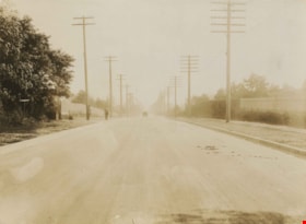
Kingsway
https://search.heritageburnaby.ca/link/archivedescription34544
- Repository
- City of Burnaby Archives
- Date
- 1914
- Collection/Fonds
- Burnaby Historical Society fonds
- Description Level
- Item
- Physical Description
- 1 photograph : sepia ; 15.3 x 20.7 cm mounted on cardboard
- Scope and Content
- Photograph of Kingsway looking southeast towards Edmonds Street. Sidewalk and utility poles run alongside the road.
- Repository
- City of Burnaby Archives
- Date
- 1914
- Collection/Fonds
- Burnaby Historical Society fonds
- Subseries
- Photographs subseries
- Physical Description
- 1 photograph : sepia ; 15.3 x 20.7 cm mounted on cardboard
- Description Level
- Item
- Record No.
- 044-004
- Access Restriction
- No restrictions
- Reproduction Restriction
- No known restrictions
- Accession Number
- BHS2007-04
- Scope and Content
- Photograph of Kingsway looking southeast towards Edmonds Street. Sidewalk and utility poles run alongside the road.
- Subjects
- Geographic Features - Roads
- Media Type
- Photograph
- Notes
- Title based on contents of photograph
- Geographic Access
- Kingsway
- Historic Neighbourhood
- Edmonds (Historic Neighbourhood)
- Planning Study Area
- Richmond Park Area
- Marlborough Area
Images
![Kingsway, [1914] thumbnail](/media/hpo/_Data/_BVM_Images/1971/197200110008.jpg?width=280)
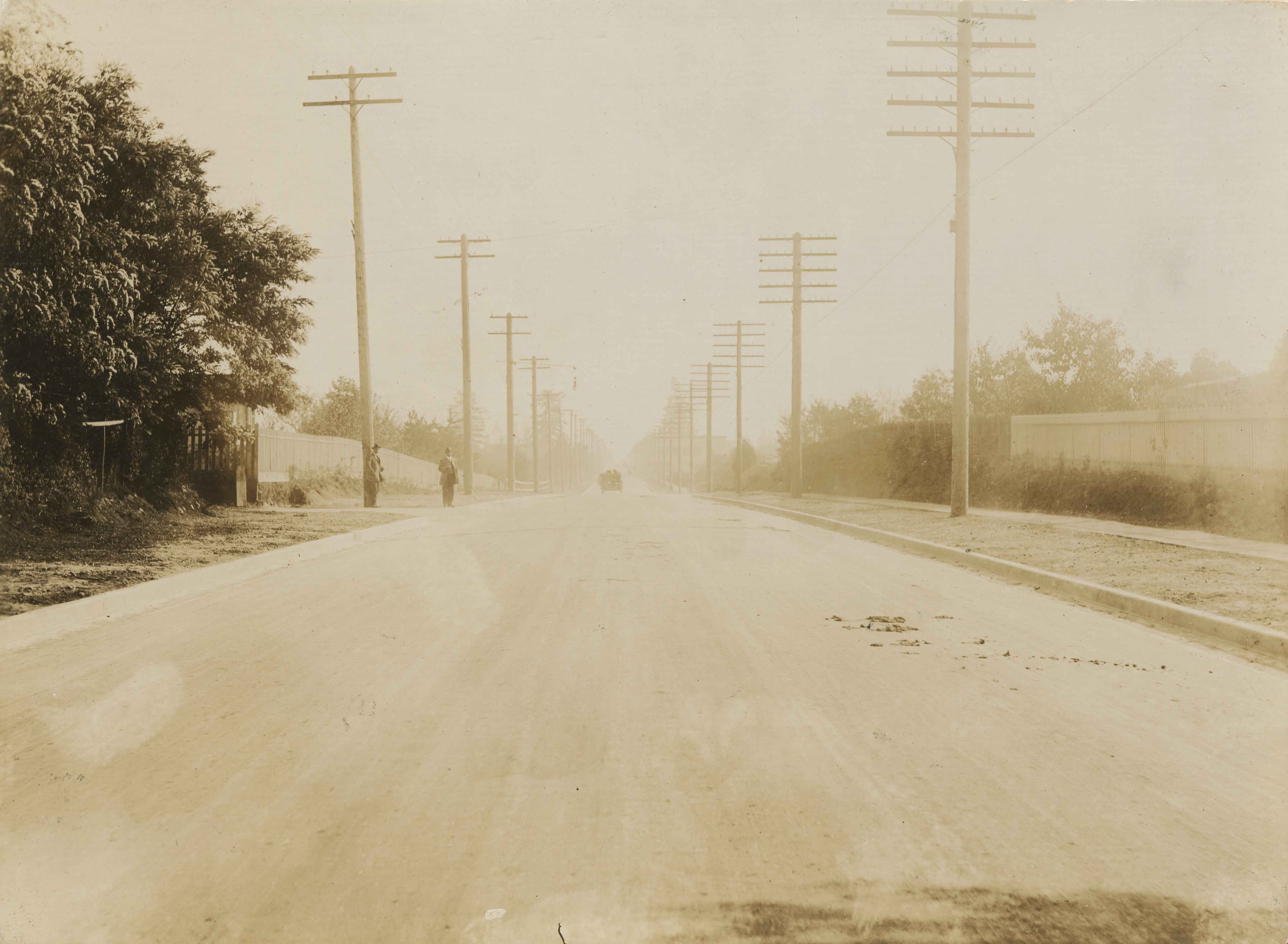
Kingsway
https://search.heritageburnaby.ca/link/museumdescription3094
- Repository
- Burnaby Village Museum
- Date
- [1914]
- Collection/Fonds
- Burnaby Village Museum Photograph collection
- Description Level
- Item
- Physical Description
- 1 photograph : b&w glass negative ; 15.8 x 21.1 cm
- Scope and Content
- Photograph of a paved road lined with electric posts, a sidewalk and fences. There are two unidentified men in suits and bowler hats standing on one side of the road, each by a different electric post. A car is driving towards the horizon. An earlier catalogue record from 1988 notes that the view …
- Repository
- Burnaby Village Museum
- Collection/Fonds
- Burnaby Village Museum Photograph collection
- Description Level
- Item
- Physical Description
- 1 photograph : b&w glass negative ; 15.8 x 21.1 cm
- Scope and Content
- Photograph of a paved road lined with electric posts, a sidewalk and fences. There are two unidentified men in suits and bowler hats standing on one side of the road, each by a different electric post. A car is driving towards the horizon. An earlier catalogue record from 1988 notes that the view is of Kingsway looking east from Willingdon Avenue towards the community of McKay and Kingsway. It also notes that the McKay Block is visible on the far right side of the photograph at McKay Avenue and Kingsway. The record dates the negative ca. 1914.
- Subjects
- Geographic Features - Roads
- Geographic Access
- Kingsway
- Willingdon Avenue
- Accession Code
- HV972.11.8
- Access Restriction
- No restrictions
- Reproduction Restriction
- No known restrictions
- Date
- [1914]
- Media Type
- Photograph
- Historic Neighbourhood
- Central Park (Historic Neighbourhood)
- Planning Study Area
- Maywood Area
- Scan Resolution
- 300
- Scan Date
- 14/8/2006
- Scale
- 100
- Notes
- Title based on contents of photograph
- 1 b&w contact print accompanying negative
Images
![Kingsway, [1914] thumbnail](/media/hpo/_Data/_BVM_Images/1971/197200110008.jpg)
![Kingsway, [1914] thumbnail](/media/hpo/_Data/_BVM_Images/1971/197200110022.jpg?width=280)
Kingsway
https://search.heritageburnaby.ca/link/museumdescription3108
- Repository
- Burnaby Village Museum
- Date
- [1914]
- Collection/Fonds
- Burnaby Village Museum Photograph collection
- Description Level
- Item
- Physical Description
- 1 photograph : b&w glass negative ; 15.8 x 21.1 cm
- Scope and Content
- Photograph of a paved street lined on both sides with curbs and electric poles. There appears to be a car in the distance, as well as an idustrial building on the right-hand side of the road. An earlier catalogue record from 1988 conjectures that the street is Kingsway, probably in Burnaby, between…
- Repository
- Burnaby Village Museum
- Collection/Fonds
- Burnaby Village Museum Photograph collection
- Description Level
- Item
- Physical Description
- 1 photograph : b&w glass negative ; 15.8 x 21.1 cm
- Scope and Content
- Photograph of a paved street lined on both sides with curbs and electric poles. There appears to be a car in the distance, as well as an idustrial building on the right-hand side of the road. An earlier catalogue record from 1988 conjectures that the street is Kingsway, probably in Burnaby, between Sperling Avenue and Royal Oak, looking South, and that the building is possibly the Macadam making plant for the company which paved Kingsway.
- Subjects
- Geographic Features - Roads
- Geographic Access
- Kingsway
- Sperling Avenue
- Royal Oak Avenue
- Accession Code
- HV972.11.22
- Access Restriction
- No restrictions
- Reproduction Restriction
- No known restrictions
- Date
- [1914]
- Media Type
- Photograph
- Planning Study Area
- Windsor Area
- Scan Resolution
- 300
- Scan Date
- 14/8/2006
- Scale
- 100
- Notes
- Title based on contents of photograph
- 1 b&w contact print accompanying negative
Images
![Kingsway, [1914] thumbnail](/media/hpo/_Data/_BVM_Images/1971/197200110022.jpg)

Kingsway at 16th Avenue
https://search.heritageburnaby.ca/link/museumdescription3093
- Repository
- Burnaby Village Museum
- Date
- 1913
- Collection/Fonds
- Burnaby Village Museum Photograph collection
- Description Level
- Item
- Physical Description
- 1 photograph : b&w glass negative ; 15.8 x 21.1 cm
- Scope and Content
- Photograph of Kingsway looking northwest from 16th Avenue. On the lefthand side of the road, driving to New Westminster is a car with three men in suits and bowler hats. The car license plate reads, "BC/ 2720/ 1913." Following the car is a horse pulling a wagon. Further north, a small street car…
- Repository
- Burnaby Village Museum
- Collection/Fonds
- Burnaby Village Museum Photograph collection
- Description Level
- Item
- Physical Description
- 1 photograph : b&w glass negative ; 15.8 x 21.1 cm
- Scope and Content
- Photograph of Kingsway looking northwest from 16th Avenue. On the lefthand side of the road, driving to New Westminster is a car with three men in suits and bowler hats. The car license plate reads, "BC/ 2720/ 1913." Following the car is a horse pulling a wagon. Further north, a small street car can be seen, probably moving southward. According to the 1988 catalogue record, the two houses on the left are separated by Hubert Avenue. The larger house on the left is the home of of Mr. and Mrs. John McNiven, now demolished. The smaller house in the distance, being constructed, is the Britton family home. On the right in the distance, the roof and twin chimneys of the 1890s Stride home can be seen, which later became the Sylvan Court Apartment Building.
- Subjects
- Geographic Features - Roads
- Geographic Access
- Kingsway
- 16th Avenue
- Accession Code
- HV972.11.7
- Access Restriction
- No restrictions
- Reproduction Restriction
- No known restrictions
- Date
- 1913
- Media Type
- Photograph
- Historic Neighbourhood
- Edmonds (Historic Neighbourhood)
- Planning Study Area
- Edmonds Area
- Stride Avenue Area
- Scan Resolution
- 300
- Scan Date
- 14/8/2006
- Scale
- 100
- Notes
- Title based on contents of photograph
- 1 b&w contact print accompanying negative
Images
