Narrow Results By
Subject
- Accidents - Automobile Accidents 1
- Advertising Medium - Signs and Signboards 20
- Aerial Photographs 34
- Agricultural Tools and Equipment 2
- Agricultural Tools and Equipment - Gardening Equipment 4
- Agricultural Tools and Equipment - Plows 2
- Agriculture 2
- Agriculture - Farms 10
- Agriculture - Fruit and Berries 2
- Animals 4
- Animals - Bears 2
- Animals - Birds 28
![Burnaby creek conservationists, [2002] thumbnail](/media/hpo/_Data/_Archives_Images/_Unrestricted/535/535-1959-1.jpg?width=280)
Burnaby creek conservationists
https://search.heritageburnaby.ca/link/archivedescription96276
- Repository
- City of Burnaby Archives
- Date
- [2002]
- Collection/Fonds
- Burnaby NewsLeader photograph collection
- Description Level
- File
- Physical Description
- 4 photographs (tiff) : col.
- Scope and Content
- File contains photographs of volunteer conservationists with the Eagle Creek Streamkeepers, Byrne Creek Streamkeepers, and Sapperton Fish & Game Club at work in the Lake City area by Eagle Creek and the Brunette River. Photographs depict Nick Kvenich, of the Eagle Creek Streamkeepers, in a creek; m…
- Repository
- City of Burnaby Archives
- Date
- [2002]
- Collection/Fonds
- Burnaby NewsLeader photograph collection
- Physical Description
- 4 photographs (tiff) : col.
- Description Level
- File
- Record No.
- 535-1959
- Access Restriction
- No restrictions
- Reproduction Restriction
- No restrictions
- Accession Number
- 2018-12
- Scope and Content
- File contains photographs of volunteer conservationists with the Eagle Creek Streamkeepers, Byrne Creek Streamkeepers, and Sapperton Fish & Game Club at work in the Lake City area by Eagle Creek and the Brunette River. Photographs depict Nick Kvenich, of the Eagle Creek Streamkeepers, in a creek; members of the Byrne Creek Streamkeepers observing a storm drain; and Elmer Rudolf feeding fish at a Sapperton Fish & Game Club hatchery.
- Subjects
- Geographic Features - Creeks
- Geographic Features - Lakes and Ponds
- Geographic Features - Ravines
- Geographic Features - Streams
- Media Type
- Photograph
- Photographer
- Bartel, Mario
- Notes
- Title based on caption
- Collected by editorial for use in a March 2002 issue of the Burnaby NewsLeader
- Caption from metadata for 535-1959-1: "Nick Kvenich is one of the founding members of the Eagle Creek Streamkeepers, which is looking to preserve the habitat of the creek that runs down from Squint Lake into a ravine below the Lake City industrial area."
- Caption from metadata for 535-1959-2: "Joan Carne (r) and Louise Towell, of the Byrne Creek Streamkeepers, examine a storm drain in an industrial area above the creek. The habitat faces constant pressure from businesses and homeowners who pour solvents, soaps and substances into the drains without thought to the consequences."
- Caption from metadata for 535-1959-3: "Nick Kvenich, one of the founding members of the Eagle Creek Streamkeepers, climbs through a fallen tree that is blocking a trail that runs alongside the creek, in a ravine below the Lake City industrial area. Although the tree will eventually be cleared by the GVRD, Kvenich says he prefers if such obstacles be left alone, as they would discourage people who might abuse the habitat."
- Caption from metadata for 535-1959-4: "Elmer Rudolf feeds a new batch of coho fry at the Sapperton Fish & Game Club's hatchery, near the Brunette River. The fry are normally fed by a timed conveyor belt, but that is supplemented by hand feedings to give the weaker fish a chance."
- Geographic Access
- Brunette River
- Eagle Creek
- Planning Study Area
- Lake City Area
Images
![Burnaby creek conservationists, [2002] thumbnail](/media/hpo/_Data/_Archives_Images/_Unrestricted/535/535-1959-1.jpg)
![Burnaby Mountain, [between 1958 and 1965] (date of original), copied 1991 thumbnail](/media/hpo/_Data/_Archives_Images/_Unrestricted/370/370-797.jpg?width=280)
Burnaby Mountain
https://search.heritageburnaby.ca/link/archivedescription38210
- Repository
- City of Burnaby Archives
- Date
- [between 1958 and 1965] (date of original), copied 1991
- Collection/Fonds
- Burnaby Historical Society fonds
- Description Level
- Item
- Physical Description
- 1 photograph : b&w ; 3.2 x 5.1 cm print on contact sheet 20.5 x 26.8 cm
- Scope and Content
- Aerial photograph of Centennial Park, Burnaby Mountain and Burrard Inlet looking east.
- Repository
- City of Burnaby Archives
- Date
- [between 1958 and 1965] (date of original), copied 1991
- Collection/Fonds
- Burnaby Historical Society fonds
- Subseries
- Burnaby Image Bank subseries
- Physical Description
- 1 photograph : b&w ; 3.2 x 5.1 cm print on contact sheet 20.5 x 26.8 cm
- Description Level
- Item
- Record No.
- 370-797
- Access Restriction
- No restrictions
- Reproduction Restriction
- No restrictions
- Accession Number
- BHS1999-03
- Scope and Content
- Aerial photograph of Centennial Park, Burnaby Mountain and Burrard Inlet looking east.
- Subjects
- Aerial Photographs
- Geographic Features - Inlets
- Geographic Features - Mountains
- Geographic Features - Parks
- Media Type
- Photograph
- Notes
- Title based on contents of photograph
- 1 b&w copy negative accompanying
- Geographic Access
- Burnaby Mountain Conservation Area
- Planning Study Area
- Burnaby Mountain Area
Images
![Burnaby Mountain, [between 1958 and 1965] (date of original), copied 1991 thumbnail](/media/hpo/_Data/_Archives_Images/_Unrestricted/370/370-797.jpg)

Burnaby Mountain Park
https://search.heritageburnaby.ca/link/archivedescription93639
- Repository
- City of Burnaby Archives
- Date
- November 19, 1977
- Collection/Fonds
- Burnaby Public Library Contemporary Visual Archive Project
- Description Level
- Item
- Physical Description
- 1 photograph : b&w ; 12.5 x 17.5 cm
- Scope and Content
- Photograph of the hillside on the top of Burnaby Mountain Park, with a person in the foreground looking out to the view. The photograph is taken facing northwest and shows the view over the the Burrard Inlet. Capitol Hill, the North Shore Mountains, and downtown Vancouver are visible in the distanc…
- Repository
- City of Burnaby Archives
- Date
- November 19, 1977
- Collection/Fonds
- Burnaby Public Library Contemporary Visual Archive Project
- Physical Description
- 1 photograph : b&w ; 12.5 x 17.5 cm
- Description Level
- Item
- Record No.
- 556-596
- Access Restriction
- No restrictions
- Reproduction Restriction
- Reproduce for fair dealing purposes only
- Accession Number
- 2017-57
- Scope and Content
- Photograph of the hillside on the top of Burnaby Mountain Park, with a person in the foreground looking out to the view. The photograph is taken facing northwest and shows the view over the the Burrard Inlet. Capitol Hill, the North Shore Mountains, and downtown Vancouver are visible in the distance.
- Names
- Burnaby Mountain Park
- Media Type
- Photograph
- Photographer
- van Mannen, Mark
- Notes
- Title taken from project information form
- Accompanied by a project information form and 1 photograph (b&w negative ; 9.5 x 12.5 cm)
- BPL no. 45
- Geographic Access
- Burnaby Mountain Conservation Area
- Planning Study Area
- Burnaby Mountain Area
Images


Burnaby Mountain Park
https://search.heritageburnaby.ca/link/archivedescription93640
- Repository
- City of Burnaby Archives
- Date
- November 19, 1977
- Collection/Fonds
- Burnaby Public Library Contemporary Visual Archive Project
- Description Level
- Item
- Physical Description
- 1 photograph : b&w ; 12.5 x 17.5 cm
- Scope and Content
- Photograph of the top of Burnaby Mountain Park and the view of Vancouver from the hillside, with a man standing in the foreground. The photograph is taken facing west of southwest. Capitol Hill, the Burrard Inlet, the North Shore Mountains, Vancouver, and Stanley Park are visible in the distance.
- Repository
- City of Burnaby Archives
- Date
- November 19, 1977
- Collection/Fonds
- Burnaby Public Library Contemporary Visual Archive Project
- Physical Description
- 1 photograph : b&w ; 12.5 x 17.5 cm
- Description Level
- Item
- Record No.
- 556-597
- Access Restriction
- No restrictions
- Reproduction Restriction
- Reproduce for fair dealing purposes only
- Accession Number
- 2017-57
- Scope and Content
- Photograph of the top of Burnaby Mountain Park and the view of Vancouver from the hillside, with a man standing in the foreground. The photograph is taken facing west of southwest. Capitol Hill, the Burrard Inlet, the North Shore Mountains, Vancouver, and Stanley Park are visible in the distance.
- Names
- Burnaby Mountain Park
- Media Type
- Photograph
- Photographer
- McGillivray, Don
- Notes
- Title taken from project information form
- Accompanied by a project information form and 1 photograph (b&w negative ; 9.5 x 12.5 cm)
- BPL no. 46
- Geographic Access
- Burnaby Mountain Conservation Area
- Planning Study Area
- Burnaby Mountain Area
Images


Burnaby Mountain Park
https://search.heritageburnaby.ca/link/archivedescription93645
- Repository
- City of Burnaby Archives
- Date
- November 19, 1977
- Collection/Fonds
- Burnaby Public Library Contemporary Visual Archive Project
- Description Level
- Item
- Physical Description
- 1 photograph : b&w ; 12.5 x 17.5 cm
- Scope and Content
- Photograph of the view from Burnaby Mountain of the Burrard Inlet, the oil refinery, and the mountains. The photograph is taken from Burnaby Mountain Park, facing north.
- Repository
- City of Burnaby Archives
- Date
- November 19, 1977
- Collection/Fonds
- Burnaby Public Library Contemporary Visual Archive Project
- Physical Description
- 1 photograph : b&w ; 12.5 x 17.5 cm
- Description Level
- Item
- Record No.
- 556-602
- Access Restriction
- No restrictions
- Reproduction Restriction
- Reproduce for fair dealing purposes only
- Accession Number
- 2017-57
- Scope and Content
- Photograph of the view from Burnaby Mountain of the Burrard Inlet, the oil refinery, and the mountains. The photograph is taken from Burnaby Mountain Park, facing north.
- Subjects
- Geographic Features - Inlets
- Geographic Features - Parks
- Geographic Features - Mountains
- Buildings - Industrial - Refineries
- Names
- Burnaby Mountain Park
- Media Type
- Photograph
- Photographer
- van Mannen, Mark
- Notes
- Title taken from project information form
- Accompanied by a project information form and 1 photograph (b&w negative ; 9.5 x 12.5 cm)
- BPL no. 52
- Geographic Access
- Burnaby Mountain Conservation Area
- Burrard Inlet
- Planning Study Area
- Burnaby Mountain Area
Images


Burnaby Mountain Park Looking West
https://search.heritageburnaby.ca/link/archivedescription93707
- Repository
- City of Burnaby Archives
- Date
- February 15, 1978
- Collection/Fonds
- Burnaby Public Library Contemporary Visual Archive Project
- Description Level
- Item
- Physical Description
- 1 photograph : b&w ; 12.5 x 17.5 cm
- Scope and Content
- Photograph of the view from Burnaby Mountain Park. The photograph is taken facing west and shows the park, part of the parking lot at the Burnaby Centennial Pavilion, and Capitol Hill and the mountains in the distance.
- Repository
- City of Burnaby Archives
- Date
- February 15, 1978
- Collection/Fonds
- Burnaby Public Library Contemporary Visual Archive Project
- Physical Description
- 1 photograph : b&w ; 12.5 x 17.5 cm
- Description Level
- Item
- Record No.
- 556-664
- Access Restriction
- No restrictions
- Reproduction Restriction
- Reproduce for fair dealing purposes only
- Accession Number
- 2017-57
- Scope and Content
- Photograph of the view from Burnaby Mountain Park. The photograph is taken facing west and shows the park, part of the parking lot at the Burnaby Centennial Pavilion, and Capitol Hill and the mountains in the distance.
- Subjects
- Geographic Features - Parks
- Geographic Features - Mountains
- Geographic Features - Automobile Parking Lots
- Names
- Burnaby Mountain Park
- Media Type
- Photograph
- Photographer
- Surridge, Jack
- Notes
- Title taken from project information form
- Accompanied by a project information form and 1 photograph (b&w negative ; 9.5 x 12.5 cm)
- BPL no. 112
- Geographic Access
- Burnaby Mountain Conservation Area
- Street Address
- 100 Centennial Way
- Planning Study Area
- Burnaby Mountain Area
Images

![Burnaby rivers, [2002] thumbnail](/media/hpo/_Data/_Archives_Images/_Unrestricted/535/535-2800-1.jpg?width=280)
Burnaby rivers
https://search.heritageburnaby.ca/link/archivedescription97440
- Repository
- City of Burnaby Archives
- Date
- [2002]
- Collection/Fonds
- Burnaby NewsLeader photograph collection
- Description Level
- File
- Physical Description
- 4 photographs (tiff) : col.
- Scope and Content
- File contains photographs of people with Burnaby rivers and creeks. Photographs depict BCIT river conservationist Mark Angelo posing in Deer Lake Brook by Burnaby Village Museum, and Lorna Johnson, Gordie Cook, and Jack McAfee enjoying Fraser Foreshore Park by the Fraser River.
- Repository
- City of Burnaby Archives
- Date
- [2002]
- Collection/Fonds
- Burnaby NewsLeader photograph collection
- Physical Description
- 4 photographs (tiff) : col.
- Description Level
- File
- Record No.
- 535-2800
- Access Restriction
- No restrictions
- Reproduction Restriction
- No restrictions
- Accession Number
- 2018-12
- Scope and Content
- File contains photographs of people with Burnaby rivers and creeks. Photographs depict BCIT river conservationist Mark Angelo posing in Deer Lake Brook by Burnaby Village Museum, and Lorna Johnson, Gordie Cook, and Jack McAfee enjoying Fraser Foreshore Park by the Fraser River.
- Media Type
- Photograph
- Photographer
- Bartel, Mario
- Notes
- Title based on caption
- Collected by editorial for use in a September 2002 issue of the Burnaby NewsLeader
- Caption from metadata for 535-2800-1 and 535-2800-2: "Mark Angelo, of BCIT, who's made it his mission to save and preserve Burnaby's rivers and creeks, says he's particularly proud of Deer Lake Brook, as it babbles through Burnaby Village Museum, on its way to Burnaby Lake."
- Caption from metadata for 535-2800-3: "Lorna Johnson hits a tennis ball out into the Fraser River at Fraser Foreshore Park, to her dog, Keiko."
- Caption from metadata for 535-2800-4: "Gordie Cook and Jack McAfee shoot the breeze and enjoy the sunshine along the Fraser River, at Fraser Foreshore Park in Burnaby."
- Geographic Access
- Deer Lake Brook
- Burnaby Fraser Foreshore Park
- Fraser River
- Historic Neighbourhood
- Fraser Arm (Historic Neighbourhood)
- Burnaby Lake (Historic Neighbourhood)
- Planning Study Area
- Morley-Buckingham Area
- Big Bend Area
Images
![Burnaby rivers, [2002] thumbnail](/media/hpo/_Data/_Archives_Images/_Unrestricted/535/535-2800-1.jpg)
![Byrne Creek Streamkeepers, [2001] thumbnail](/media/hpo/_Data/_Archives_Images/_Unrestricted/535/535-2194-1.jpg?width=280)
Byrne Creek Streamkeepers
https://search.heritageburnaby.ca/link/archivedescription96572
- Repository
- City of Burnaby Archives
- Date
- [2001]
- Collection/Fonds
- Burnaby NewsLeader photograph collection
- Description Level
- File
- Physical Description
- 2 photographs (tiff) : col.
- Scope and Content
- File contains members of the Byrne Creek Streamkeepers during their work to protect the waterways and salmon in the area. Photographs depict Bob Fuller checking a waterflow measuring gauge and Joan Carne standing in the overflow channel at the salmon rearing ponds below Marine Drive.
- Repository
- City of Burnaby Archives
- Date
- [2001]
- Collection/Fonds
- Burnaby NewsLeader photograph collection
- Physical Description
- 2 photographs (tiff) : col.
- Description Level
- File
- Record No.
- 535-2194
- Access Restriction
- No restrictions
- Reproduction Restriction
- No restrictions
- Accession Number
- 2018-12
- Scope and Content
- File contains members of the Byrne Creek Streamkeepers during their work to protect the waterways and salmon in the area. Photographs depict Bob Fuller checking a waterflow measuring gauge and Joan Carne standing in the overflow channel at the salmon rearing ponds below Marine Drive.
- Subjects
- Persons - Volunteers
- Geographic Features - Creeks
- Geographic Features - Lakes and Ponds
- Geographic Features - Streams
- Media Type
- Photograph
- Photographer
- Bartel, Mario
- Notes
- Title based on caption
- Collected by editorial for use in a March 2001 issue of the Burnaby NewsLeader
- Caption from metadata for 535-2194-1: "Bob Fuller, of the Byrne Creek Streamkeepers, checks the guage that measures the flow of water which is released from the holding pond below Marine Drive to the salmon spawning beds downstream."
- Caption from metadata for 535-2194-2: "Joan Carne of the Byrne Creek Streamkeepers stands in the overflow channel at the salmon rearing ponds below Marine Drive. Although last week's chemical spill into Byrne Creek didn't reach the ponds, Carne says it's a constant battle to educate people to take care of the area's creeks and streams."
- Geographic Access
- Marine Drive
- Byrne Creek
- Planning Study Area
- Stride Hill Area
Images
![Byrne Creek Streamkeepers, [2001] thumbnail](/media/hpo/_Data/_Archives_Images/_Unrestricted/535/535-2194-1.jpg)

Canada geese in the park
https://search.heritageburnaby.ca/link/archivedescription59046
- Repository
- City of Burnaby Archives
- Date
- ca.1983
- Collection/Fonds
- Columbian Newspaper collection
- Description Level
- Item
- Physical Description
- 1 photograph : b&w ; 17.5 x 20 cm
- Scope and Content
- Photograph of a flock of Canada geese on a grassy field in a park.
- Repository
- City of Burnaby Archives
- Date
- ca.1983
- Collection/Fonds
- Columbian Newspaper collection
- Physical Description
- 1 photograph : b&w ; 17.5 x 20 cm
- Description Level
- Item
- Record No.
- 480-1452
- Access Restriction
- No restrictions
- Reproduction Restriction
- May be restricted by third party rights
- Accession Number
- 2009-01
- Scope and Content
- Photograph of a flock of Canada geese on a grassy field in a park.
- Subjects
- Geographic Features - Fields
- Geographic Features - Lakes and Ponds
- Geographic Features - Parks
- Animals - Birds
- Media Type
- Photograph
- Photographer
- Battistoni, Peter
- Notes
- Title based on contents of photograph
- Photographer's stamp on verso
- Note on verso reads: "page 4 / Burnaby / Today / PMT 100%"
Images


Deer Lake Gibraltar
https://search.heritageburnaby.ca/link/archivedescription34312
- Repository
- City of Burnaby Archives
- Date
- 1924
- Collection/Fonds
- Burnaby Historical Society fonds
- Description Level
- Item
- Physical Description
- 1 photograph : b&w ; 8.1 x 13.2 cm
- Scope and Content
- Photograph of the "Gibraltar" rock at mouth of Deer Lake Creek. This photograph was taken during the winter of 1924 and the lake is frozen over with ice. The surface of the lake is covered with marks made by ice skates. Deer Lake Creek is historically known as Deer Lake Brook.
- Repository
- City of Burnaby Archives
- Date
- 1924
- Collection/Fonds
- Burnaby Historical Society fonds
- Subseries
- Peers family subseries
- Physical Description
- 1 photograph : b&w ; 8.1 x 13.2 cm
- Description Level
- Item
- Record No.
- 020-019
- Access Restriction
- No restrictions
- Reproduction Restriction
- No known restrictions
- Accession Number
- BHS2007-04
- Scope and Content
- Photograph of the "Gibraltar" rock at mouth of Deer Lake Creek. This photograph was taken during the winter of 1924 and the lake is frozen over with ice. The surface of the lake is covered with marks made by ice skates. Deer Lake Creek is historically known as Deer Lake Brook.
- Subjects
- Geographic Features - Creeks
- Geographic Features - Lakes and Ponds
- Geographic Features - Rock Formations
- Media Type
- Photograph
- Notes
- Title based on caption accompanying photograph
- Geographic Access
- Deer Lake Brook
- Historic Neighbourhood
- Burnaby Lake (Historic Neighbourhood)
- Planning Study Area
- Morley-Buckingham Area
Images

![Indian Arm, [1995] thumbnail](/media/Hpo/_Data/_Archives_Images/_Unrestricted/629/629-004.jpg?width=280)
Indian Arm
https://search.heritageburnaby.ca/link/archivedescription97803
- Repository
- City of Burnaby Archives
- Date
- [1995]
- Collection/Fonds
- Burnaby Mountain Preservation Society fonds
- Description Level
- Item
- Physical Description
- 1 photograph : col. slide ; 35 mm
- Scope and Content
- Photograph of Indian Arm.
- Repository
- City of Burnaby Archives
- Date
- [1995]
- Collection/Fonds
- Burnaby Mountain Preservation Society fonds
- Physical Description
- 1 photograph : col. slide ; 35 mm
- Description Level
- Item
- Record No.
- 629-004
- Access Restriction
- No restrictions
- Reproduction Restriction
- Reproduce for fair dealing purposes only
- Accession Number
- 2006-13
- Scope and Content
- Photograph of Indian Arm.
- Media Type
- Photograph
- Notes
- Handwritten note on slide reads: "Indian Arm."
Images
![Indian Arm, [1995] thumbnail](/media/Hpo/_Data/_Archives_Images/_Unrestricted/629/629-004.jpg)
Interview with John Templeton, Alan James and Christine Leston by Kathy Bossort October 26, 2015 - Track 9
https://search.heritageburnaby.ca/link/oralhistory595
- Repository
- City of Burnaby Archives
- Date Range
- 1995-2015
- Length
- 0:12:28
- Summary
- This portion of the interview is about the Stoney Creek Environment Committee members’ discussion of how the history of the forest and natural area on Burnaby Mountain forms part of our appreciation for the mountain. They talk about the impact of the conservation area on adjacent urban areas such a…
- Repository
- City of Burnaby Archives
- Summary
- This portion of the interview is about the Stoney Creek Environment Committee members’ discussion of how the history of the forest and natural area on Burnaby Mountain forms part of our appreciation for the mountain. They talk about the impact of the conservation area on adjacent urban areas such as the neighbourhood of Forest Grove, and the future of the urban forest on Burnaby Mountain.
- Date Range
- 1995-2015
- Length
- 0:12:28
- Geographic Access
- Burnaby Mountain Conservation Area
- Stoney Creek
- Interviewer
- Bossort, Kathy
- Interview Date
- October 26, 2015
- Scope and Content
- Recording is of an interview with John Templeton, Alan James & Christine Leston, members of the Stoney Creek Environment Committee, conducted by Kathy Bossort. The three members of SCEC were among 23 participants interviewed as part of the Community Heritage Commission’s Burnaby Mountain Oral History Project. The interview is mainly about the history and work of the stream keeper group Stoney Creek Environment Committee (SCEC) and the Stoney Creek Environmental Working Group, and about SCEC’s founder Jennifer Atkinson. The interview is made richer by the complementary views of the three interviewees, John Templeton (SCEC Chair), Alan James (Member-at-Large - Education), and Christine Leston (Treasurer).
- Biographical Notes
- The Stoney Creek Environment Committee is a streamkeeper group and registered non-profit society dedicated to protecting and restoring viable salmon-bearing streams within the Stoney Creek Watershed. (Stoney Creek originates on Burnaby Mountain and is part of the Brunette watershed which empties into the Fraser River.) The volunteer group, formed in 1995, was guided by the tireless efforts of Jennifer Atchison (1938-2010) after whom the Jennifer Atchison Environmental Centre in North Burnaby is named. The volunteer members of SCEC monitor water quality, generate inventories and reports on the biophysical assets and health of the watershed, provide educational opportunities, enhance stream and stream bank habitat, and speak on behalf of the Stoney Creek watershed. One of its key events is The Great Salmon Send-Off, the release of young salmon into Stoney Creek in May, which celebrated its 25th anniversary in 2015. The Stoney Creek Environmental Working Group (1999-present), managed by the City of Burnaby, undertakes to coordinate the actions of all stakeholders in the Stoney Creek watershed. It is comprised of representatives from community groups, such as SCEC, governmental and institutional agencies, and industries who are committed to sustaining and improving the quality of the Stoney Creek watershed’s water, wildlife and environment. John Templeton, currently SCEC Chair, joined SCEC in 2004. He was born in Coleraine ,County Londonderry, Northern Ireland, in 1957, and after immigrating to Canada, came to live in Burnaby in 1992, first in Forest Grove (1992-2014) and then in Forest Hills. He works as a millwright. Alan James,Member-at-large - Education, joined SCEC in 2003 He was born in 1939 in Berkeley, California, and came to live in Burnaby in about 2000. He is a retired geophycisist and computer consultant. Christine Leston joined SCEC in 1997, serving first as Secretary and then as Treasurer. She was born in 1943 in Cheshire, England, and came to live in Burnaby in 1974, first in Greentree Village, then Simon Fraser Village (1974-2004) and now the Edmonds area. She is a retired technical writer.
- Total Tracks
- 9
- Total Length
- 2:08:27
- Interviewee Name
- Templeton, John R.
- James, Alan C.
- Leston, Christine
- Interview Location
- Jennifer Atchison Environmental Centre, Burnaby
- Interviewer Bio
- Kathy Bossort is a retired archivist living in Ladner, BC. She worked at the Delta Museum and Archives after graduating from SLAIS (UBC) in 2001 with Masters degrees in library science and archival studies. Kathy grew up in Calgary, Alberta, and, prior to this career change, she lived in the West Kootenays, earning her living as a cook for BC tourist lodges and work camps. She continues to be interested in oral histories as a way to fill the gaps in the written record and bring richer meaning to history.
- Collection/Fonds
- Community Heritage Commission Special Projects fonds
- Media Type
- Sound Recording
Audio Tracks
Track nine of interview with John Templeton, Alan James & Christine Leston
Track nine of interview with John Templeton, Alan James & Christine Leston
https://search.heritageburnaby.ca/media/hpo/_Data/_Archives_Oral_Histories/_Unrestricted/MSS196-006/MSS196-006_Track_9.mp3Locations in Vancouver and British Columbia
https://search.heritageburnaby.ca/link/archivedescription58315
- Repository
- City of Burnaby Archives
- Date
- [19--]
- Collection/Fonds
- Burnaby Historical Society fonds
- Description Level
- Item
- Physical Description
- 1 album (61 photographs : b&w) ; 26.5 x 31.5 cm
- Scope and Content
- Photographic album of locations in Vancouver, the Lower Mainland, and other locations in British Columbia and Alberta. Photographs are reproductions of photographs taken between approximately 1880-1900, which were collected and pasted into the album.
- Repository
- City of Burnaby Archives
- Date
- [19--]
- Collection/Fonds
- Burnaby Historical Society fonds
- Subseries
- Fraser Wilson subseries
- Physical Description
- 1 album (61 photographs : b&w) ; 26.5 x 31.5 cm
- Description Level
- Item
- Record No.
- 492-001
- Access Restriction
- In Archives only
- Reproduction Restriction
- No reproduction permitted
- Accession Number
- BHS1988-06
- Scope and Content
- Photographic album of locations in Vancouver, the Lower Mainland, and other locations in British Columbia and Alberta. Photographs are reproductions of photographs taken between approximately 1880-1900, which were collected and pasted into the album.
- Names
- Wilson, Fraser
- Media Type
- Photograph
- Notes
- Title based on content of item
- Table of contents of pictures and page numbers pasted in the front cover of the album
- 1 photograph loose in between pages 12-13 of the album; reproduction of a photograph from Vancouver City Archives.
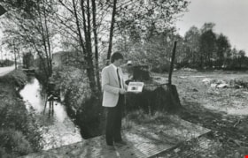
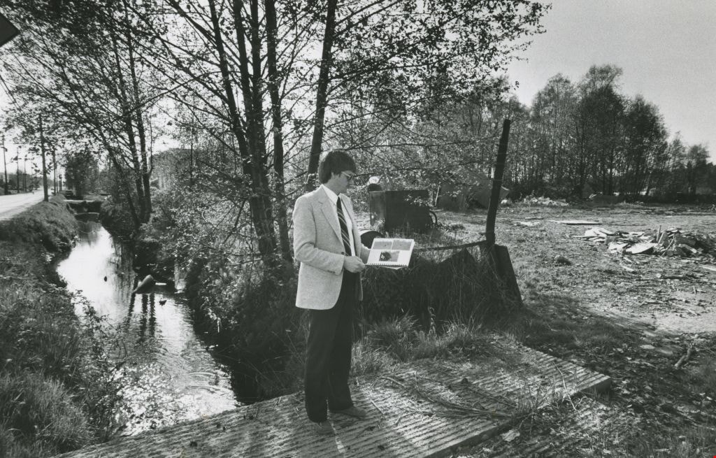
Man in the park
https://search.heritageburnaby.ca/link/archivedescription58992
- Repository
- City of Burnaby Archives
- Date
- 1983
- Collection/Fonds
- Columbian Newspaper collection
- Description Level
- Item
- Physical Description
- 1 photograph : b&w ; 18 x 25.5 cm
- Scope and Content
- Photograph of a man in a suit next to an empty lot or park. He is standing on a plank bridge over a ditch by the road that is filled with water and reviewing a book or report.
- Repository
- City of Burnaby Archives
- Date
- 1983
- Collection/Fonds
- Columbian Newspaper collection
- Physical Description
- 1 photograph : b&w ; 18 x 25.5 cm
- Description Level
- Item
- Record No.
- 480-1402
- Access Restriction
- No restrictions
- Reproduction Restriction
- No restrictions
- Accession Number
- 2009-01
- Scope and Content
- Photograph of a man in a suit next to an empty lot or park. He is standing on a plank bridge over a ditch by the road that is filled with water and reviewing a book or report.
- Media Type
- Photograph
- Photographer
- Battistoni, Peter
- Notes
- Title based on contents of photograph
- Photographer's stamp on verso
- Note on verso reads: "PMT 100% / page A-3 / Burnaby Today"
Images
![Metro Vancouver from Burnaby Mountain, [1995] thumbnail](/media/Hpo/_Data/_Archives_Images/_Unrestricted/629/629-003.jpg?width=280)
Metro Vancouver from Burnaby Mountain
https://search.heritageburnaby.ca/link/archivedescription97802
- Repository
- City of Burnaby Archives
- Date
- [1995]
- Collection/Fonds
- Burnaby Mountain Preservation Society fonds
- Description Level
- Item
- Physical Description
- 1 photograph : col. slide ; 35 mm
- Scope and Content
- Photograph of Metro Vancouver from Burnaby Mountain.
- Repository
- City of Burnaby Archives
- Date
- [1995]
- Collection/Fonds
- Burnaby Mountain Preservation Society fonds
- Physical Description
- 1 photograph : col. slide ; 35 mm
- Description Level
- Item
- Record No.
- 629-003
- Access Restriction
- No restrictions
- Reproduction Restriction
- Reproduce for fair dealing purposes only
- Accession Number
- 2006-13
- Scope and Content
- Photograph of Metro Vancouver from Burnaby Mountain.
- Media Type
- Photograph
Images
![Metro Vancouver from Burnaby Mountain, [1995] thumbnail](/media/Hpo/_Data/_Archives_Images/_Unrestricted/629/629-003.jpg)
![Trans Canada Trail, [2000] thumbnail](/media/hpo/_Data/_Archives_Images/_Unrestricted/535/535-2372.jpg?width=280)
Trans Canada Trail
https://search.heritageburnaby.ca/link/archivedescription96814
- Repository
- City of Burnaby Archives
- Date
- [2000]
- Collection/Fonds
- Burnaby NewsLeader photograph collection
- Description Level
- Item
- Physical Description
- 1 photograph (tiff) : b&w
- Scope and Content
- Photograph of an unidentified person and their dog on the Trans Canada Trail in North Burnaby, overlooking the Burrard Inlet. Industrial ports and plants on the North Shore and the North Shore mountains are visible on the other side of the Inlet.
- Repository
- City of Burnaby Archives
- Date
- [2000]
- Collection/Fonds
- Burnaby NewsLeader photograph collection
- Physical Description
- 1 photograph (tiff) : b&w
- Description Level
- Item
- Record No.
- 535-2372
- Access Restriction
- No restrictions
- Reproduction Restriction
- No restrictions
- Accession Number
- 2018-12
- Scope and Content
- Photograph of an unidentified person and their dog on the Trans Canada Trail in North Burnaby, overlooking the Burrard Inlet. Industrial ports and plants on the North Shore and the North Shore mountains are visible on the other side of the Inlet.
- Media Type
- Photograph
- Photographer
- Bartel, Mario
- Notes
- Title based on caption
- Collected by editorial for use in an April 2000 issue of the Burnaby NewsLeader
- Caption from metadata: "The Trans Canada Trail is popular with dog walkers, offering spectacular vistas of Burrard Inlet and the North Shore Mountains."
- Geographic Access
- Burrard Inlet
- Historic Neighbourhood
- Capitol Hill (Historic Neighbourhood)
- Planning Study Area
- Capitol Hill Area
Images
![Trans Canada Trail, [2000] thumbnail](/media/hpo/_Data/_Archives_Images/_Unrestricted/535/535-2372.jpg)
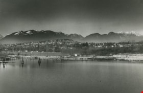
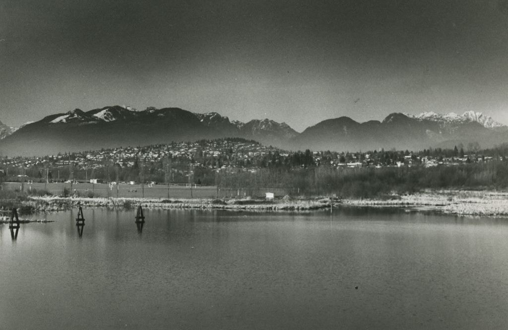
View of a Lake, City, and Mountains
https://search.heritageburnaby.ca/link/archivedescription59024
- Repository
- City of Burnaby Archives
- Date
- ca.1983
- Collection/Fonds
- Columbian Newspaper collection
- Description Level
- Item
- Physical Description
- 1 photograph : b&w
- Scope and Content
- Photograph of a lake and residential neighbourhood, with the North Shore mountains in the background.
- Repository
- City of Burnaby Archives
- Date
- ca.1983
- Collection/Fonds
- Columbian Newspaper collection
- Physical Description
- 1 photograph : b&w
- Description Level
- Item
- Record No.
- 480-1430
- Access Restriction
- No restrictions
- Reproduction Restriction
- May be restricted by third party rights
- Accession Number
- 2009-01
- Scope and Content
- Photograph of a lake and residential neighbourhood, with the North Shore mountains in the background.
- Subjects
- Geographic Features - Beaches
- Geographic Features - Lakes and Ponds
- Geographic Features - Mountains
- Media Type
- Photograph
- Photographer
- King, Basil
- Notes
- Title based on contents of photograph
Images
![4042 Yale Street, [1961 or 1962] (date of original), copied 1991 thumbnail](/media/hpo/_Data/_Archives_Images/_Unrestricted/370/370-214.jpg?width=280)
4042 Yale Street
https://search.heritageburnaby.ca/link/archivedescription37626
- Repository
- City of Burnaby Archives
- Date
- [1961 or 1962] (date of original), copied 1991
- Collection/Fonds
- Burnaby Historical Society fonds
- Description Level
- Item
- Physical Description
- 1 photograph : b&w ; 3.9 x 3.9 cm print on contact sheet 20.2 x 25.3 cm
- Scope and Content
- Photograph from above 4042 Yale Street looking northeast. Burrard Inlet and the northshore mountains are visible in the background. The photograph was taken during the winter of 1961 to 1962, and there is snow.
- Repository
- City of Burnaby Archives
- Date
- [1961 or 1962] (date of original), copied 1991
- Collection/Fonds
- Burnaby Historical Society fonds
- Subseries
- Burnaby Image Bank subseries
- Physical Description
- 1 photograph : b&w ; 3.9 x 3.9 cm print on contact sheet 20.2 x 25.3 cm
- Description Level
- Item
- Record No.
- 370-214
- Access Restriction
- No restrictions
- Reproduction Restriction
- No restrictions
- Accession Number
- BHS1999-03
- Scope and Content
- Photograph from above 4042 Yale Street looking northeast. Burrard Inlet and the northshore mountains are visible in the background. The photograph was taken during the winter of 1961 to 1962, and there is snow.
- Subjects
- Buildings - Residential - Houses
- Geographic Features - Inlets
- Geographic Features - Mountains
- Media Type
- Photograph
- Notes
- Title based on contents of photograph
- 1 b&w copy negative accompanying
- Geographic Access
- Yale Street
- Street Address
- 4042 Yale Street
- Historic Neighbourhood
- Vancouver Heights (Historic Neighbourhood)
- Planning Study Area
- Burnaby Heights Area
Images
![4042 Yale Street, [1961 or 1962] (date of original), copied 1991 thumbnail](/media/hpo/_Data/_Archives_Images/_Unrestricted/370/370-214.jpg)
6088 Cassie Avenue
https://search.heritageburnaby.ca/link/archivedescription93717
- Repository
- City of Burnaby Archives
- Date
- 1987
- Collection/Fonds
- Grover, Elliott & Co. Ltd. fonds
- Description Level
- File
- Physical Description
- 14 photographs : col. negatives ; 35 mm + 5 photographs : col. ; 10 cm x 15 cm
- Scope and Content
- Photographs of the private residence and garden located at 6088 Cassie Avenue - an address that no longer exists.
- Repository
- City of Burnaby Archives
- Date
- 1987
- Collection/Fonds
- Grover, Elliott & Co. Ltd. fonds
- Physical Description
- 14 photographs : col. negatives ; 35 mm + 5 photographs : col. ; 10 cm x 15 cm
- Description Level
- File
- Record No.
- 622-006
- Access Restriction
- No restrictions
- Reproduction Restriction
- No restrictions
- Accession Number
- 2017-39
- Scope and Content
- Photographs of the private residence and garden located at 6088 Cassie Avenue - an address that no longer exists.
- Media Type
- Photograph
- Notes
- Transcribed title
- Title transcribed from original print envelope
- File no. 87-300-B
- Geographic Access
- Cassie Avenue
- Historic Neighbourhood
- Central Park (Historic Neighbourhood)
- Planning Study Area
- Maywood Area
7837 CA Way Burnaby
https://search.heritageburnaby.ca/link/archivedescription93813
- Repository
- City of Burnaby Archives
- Date
- November 1992
- Collection/Fonds
- Grover, Elliott & Co. Ltd. fonds
- Description Level
- File
- Physical Description
- 48 photographs : col. negatives ; 35 mm + 5 photographs : col. ; 10 cm x 15 cm
- Scope and Content
- Photographs of the residential buildings located at 7837 Canada Way. Buildings include a two-storey blue-shingled house, single-storey addition, and a guest house. File also contains photographs of the Capilano suspension bridge and Capilano Suspension Bridge Park in North Vancouver.
- Repository
- City of Burnaby Archives
- Date
- November 1992
- Collection/Fonds
- Grover, Elliott & Co. Ltd. fonds
- Physical Description
- 48 photographs : col. negatives ; 35 mm + 5 photographs : col. ; 10 cm x 15 cm
- Description Level
- File
- Record No.
- 622-061
- Access Restriction
- No restrictions
- Reproduction Restriction
- No restrictions
- Accession Number
- 2017-39
- Scope and Content
- Photographs of the residential buildings located at 7837 Canada Way. Buildings include a two-storey blue-shingled house, single-storey addition, and a guest house. File also contains photographs of the Capilano suspension bridge and Capilano Suspension Bridge Park in North Vancouver.
- Media Type
- Photograph
- Notes
- Transcribed title
- Title transcribed from envelope photographs were originally housed in
- File no. 92-437-B
- Sticky note adhered to 622-061-9 print reads: "7 / View of the building looking northeast across the site".
- Sticky note adhered to 622-061-13 print reads: "6 / View of the original house and the single storey addition looking north west across the property".
- Sticky note adhered to 622-061-17 print reads: "8 / View northeast across the property from the southeast corner".
- Sticky note adhered to 622-061-21 print reads: "9 / View west from the property along the lane at the south side".
- Sticky note adhered to 622-061-26 reads: "3 / The original house now part of the guest home and the view south along the east property line".
- Sticky note adhered to 622-061-27 reads: "4 / View west along Canada Way [illegible] the subject".
- Sticky note adhered to 622-061-28 reads: "5 / The most recent addition - the single storey L shaped structure at the west end of the guesthouse".
- Sticky note adhere to 622-061-29 reads: "5A / The original house"."
- Photographer identified as "D.E."
- Geographic Access
- Canada Way
- Street Address
- 7837 Canada Way
- Planning Study Area
- Lake City Area