Narrow Results By
![David Doyle, [2002] thumbnail](/media/hpo/_Data/_Archives_Images/_Unrestricted/535/535-1981-1.jpg?width=280)
David Doyle
https://search.heritageburnaby.ca/link/archivedescription96298
- Repository
- City of Burnaby Archives
- Date
- [2002]
- Collection/Fonds
- Burnaby NewsLeader photograph collection
- Description Level
- File
- Physical Description
- 2 photographs (tiff) : col.
- Scope and Content
- File contains photographs of David Doyle on Burnaby Mountain. Photographs depict Doyle using a GPS to map streams and watercourses to gather environmental data ahead of the UniverCity development by SFU on Burnaby Mountain.
- Repository
- City of Burnaby Archives
- Date
- [2002]
- Collection/Fonds
- Burnaby NewsLeader photograph collection
- Physical Description
- 2 photographs (tiff) : col.
- Description Level
- File
- Record No.
- 535-1981
- Access Restriction
- No restrictions
- Reproduction Restriction
- No restrictions
- Accession Number
- 2018-12
- Scope and Content
- File contains photographs of David Doyle on Burnaby Mountain. Photographs depict Doyle using a GPS to map streams and watercourses to gather environmental data ahead of the UniverCity development by SFU on Burnaby Mountain.
- Subjects
- Geographic Features - Streams
- Names
- Simon Fraser University
- Media Type
- Photograph
- Photographer
- Bartel, Mario
- Notes
- Title based on caption
- Collected by editorial for use in a February 2002 issue of the Burnaby NewsLeader
- Caption from metadata: "David Doyle uses a satellite Global Positioning System to map streams and watercourses on Burnaby Mountain, in preparation for the Univer-City development around Simon Fraser University. The data he accumulates will be used by the Stoney Creek Environmental Committee to guage the impact construction may have on water quality and fish habitats."
- Geographic Access
- Burnaby Mountain Conservation Area
- Planning Study Area
- Burnaby Mountain Area
Images
![David Doyle, [2002] thumbnail](/media/hpo/_Data/_Archives_Images/_Unrestricted/535/535-1981-1.jpg)
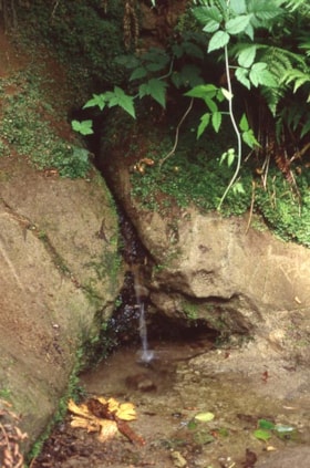
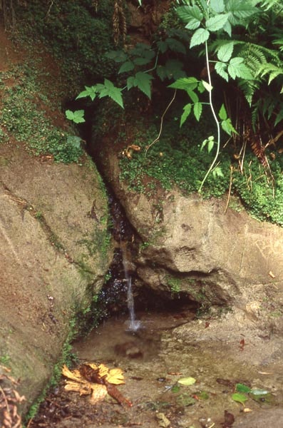
Small stream running out of a rock Burnaby Mountain
https://search.heritageburnaby.ca/link/archivedescription97895
- Repository
- City of Burnaby Archives
- Date
- 1996
- Collection/Fonds
- Burnaby Mountain Preservation Society fonds
- Description Level
- Item
- Physical Description
- 1 photograph : col. slide ; 35 mm
- Scope and Content
- Photograph of a small stream running out of a rock.
- Repository
- City of Burnaby Archives
- Date
- 1996
- Collection/Fonds
- Burnaby Mountain Preservation Society fonds
- Physical Description
- 1 photograph : col. slide ; 35 mm
- Description Level
- Item
- Record No.
- 629-096
- Access Restriction
- No restrictions
- Reproduction Restriction
- Reproduce for fair dealing purposes only
- Accession Number
- 2006-13
- Scope and Content
- Photograph of a small stream running out of a rock.
- Subjects
- Geographic Features - Streams
- Media Type
- Photograph
- Notes
- Stamp on slide reads: "July 08, 1996."
- Geographic Access
- Burnaby Mountain Conservation Area
- Planning Study Area
- Burnaby Mountain Area
Images
![Tree fallen over a stream on Burnaby Mountain, [1995] thumbnail](/media/Hpo/_Data/_Archives_Images/_Unrestricted/629/629-098.jpg?width=280)
Tree fallen over a stream on Burnaby Mountain
https://search.heritageburnaby.ca/link/archivedescription97897
- Repository
- City of Burnaby Archives
- Date
- [1995]
- Collection/Fonds
- Burnaby Mountain Preservation Society fonds
- Description Level
- Item
- Physical Description
- 1 photograph : col. slide ; 35 mm
- Scope and Content
- Photograph of a fallen log acting as a bridge across a shallow stream.
- Repository
- City of Burnaby Archives
- Date
- [1995]
- Collection/Fonds
- Burnaby Mountain Preservation Society fonds
- Physical Description
- 1 photograph : col. slide ; 35 mm
- Description Level
- Item
- Record No.
- 629-098
- Access Restriction
- No restrictions
- Reproduction Restriction
- Reproduce for fair dealing purposes only
- Accession Number
- 2006-13
- Scope and Content
- Photograph of a fallen log acting as a bridge across a shallow stream.
- Subjects
- Geographic Features - Streams
- Media Type
- Photograph
- Geographic Access
- Burnaby Mountain Conservation Area
- Planning Study Area
- Burnaby Mountain Area
Images
![Tree fallen over a stream on Burnaby Mountain, [1995] thumbnail](/media/Hpo/_Data/_Archives_Images/_Unrestricted/629/629-098.jpg)