Narrow Results By
Subject
- Aerial Photographs 1
- Animals - Dogs 3
- Buildings - Commercial 1
- Buildings - Residential - Houses 2
- Buildings - Residential - Seniors Housing 1
- Construction 1
- Events - Royal Visits 1
- Geographic Features - Inlets 1
- Geographic Features - Roads 25
- Land Clearing 1
- Natural Phenomena - Snow 6
- Plants - Flowers 1
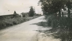
![1000 Block Gilley Avenue, [1955] (date of original), copied 1991 thumbnail](/media/hpo/_Data/_Archives_Images/_Unrestricted/370/370-672.jpg?width=280)
1000 Block Gilley Avenue
https://search.heritageburnaby.ca/link/archivedescription38085
- Repository
- City of Burnaby Archives
- Date
- [1955] (date of original), copied 1991
- Collection/Fonds
- Burnaby Historical Society fonds
- Description Level
- Item
- Physical Description
- 1 photograph : b&w ; 3.1 x 3.0 cm print on contact sheet 21.5 x 26.8 cm
- Scope and Content
- Photograph of the 1000 block of Gilley Avenue (later renumbered the 8000 block) looking south towards Marine Drive in the snow.
- Repository
- City of Burnaby Archives
- Date
- [1955] (date of original), copied 1991
- Collection/Fonds
- Burnaby Historical Society fonds
- Subseries
- Burnaby Image Bank subseries
- Physical Description
- 1 photograph : b&w ; 3.1 x 3.0 cm print on contact sheet 21.5 x 26.8 cm
- Description Level
- Item
- Record No.
- 370-672
- Access Restriction
- No restrictions
- Reproduction Restriction
- No restrictions
- Accession Number
- BHS1999-03
- Scope and Content
- Photograph of the 1000 block of Gilley Avenue (later renumbered the 8000 block) looking south towards Marine Drive in the snow.
- Media Type
- Photograph
- Notes
- Title based on contents of photograph
- 1 b&w copy negative accompanying
- Negative has a pink cast
- Geographic Access
- Gilley Avenue
- Planning Study Area
- Clinton-Glenwood Area
- Stride Hill Area
Images
![1000 Block Gilley Avenue, [1955] (date of original), copied 1991 thumbnail](/media/hpo/_Data/_Archives_Images/_Unrestricted/370/370-672.jpg)
![1935 Ford in the Snow, [193-?] (date of original), copied 1992 thumbnail](/media/hpo/_Data/_Archives_Images/_Unrestricted/315/315-373.jpg?width=280)
1935 Ford in the Snow
https://search.heritageburnaby.ca/link/archivedescription36915
- Repository
- City of Burnaby Archives
- Date
- [193-?] (date of original), copied 1992
- Collection/Fonds
- Burnaby Historical Society fonds
- Description Level
- Item
- Physical Description
- 1 photograph : b&w ; 8.8 x 12.7 cm print
- Scope and Content
- Photograph of a 1935 Ford beside a snow bank.
- Repository
- City of Burnaby Archives
- Date
- [193-?] (date of original), copied 1992
- Collection/Fonds
- Burnaby Historical Society fonds
- Subseries
- Burnaby Centennial Anthology subseries
- Physical Description
- 1 photograph : b&w ; 8.8 x 12.7 cm print
- Description Level
- Item
- Record No.
- 315-373
- Access Restriction
- No restrictions
- Reproduction Restriction
- No known restrictions
- Accession Number
- BHS1994-04
- Scope and Content
- Photograph of a 1935 Ford beside a snow bank.
- Media Type
- Photograph
- Notes
- Title based on contents of photograph
Images
![1935 Ford in the Snow, [193-?] (date of original), copied 1992 thumbnail](/media/hpo/_Data/_Archives_Images/_Unrestricted/315/315-373.jpg)
![Boundary Road and Kingsway, [1959] thumbnail](/media/Hpo/_Data/_Archives_Images/_Unrestricted/001/113-001.jpg?width=280)
Boundary Road and Kingsway
https://search.heritageburnaby.ca/link/archivedescription34709
- Repository
- City of Burnaby Archives
- Date
- [1959]
- Collection/Fonds
- Burnaby Historical Society fonds
- Description Level
- Item
- Physical Description
- 1 photograph : b&w ; 16.0 x 25.3 cm
- Scope and Content
- Photograph of buildings at Boundary Road and Kingsway, southwest corner. A typed description on the back of the photograph reads, "The new Hemlock (automatic) and old Dexter (manual) exchanges. / B.C. Telephone Company."
- Repository
- City of Burnaby Archives
- Date
- [1959]
- Collection/Fonds
- Burnaby Historical Society fonds
- Subseries
- Photographs subseries
- Physical Description
- 1 photograph : b&w ; 16.0 x 25.3 cm
- Description Level
- Item
- Record No.
- 113-001
- Access Restriction
- No restrictions
- Reproduction Restriction
- Reproduce for fair dealing purposes only
- Accession Number
- BHS2007-04
- Scope and Content
- Photograph of buildings at Boundary Road and Kingsway, southwest corner. A typed description on the back of the photograph reads, "The new Hemlock (automatic) and old Dexter (manual) exchanges. / B.C. Telephone Company."
- Media Type
- Photograph
- Photographer
- Williams Brothers Photographers Limited
- Notes
- Title based on contents of photograph
- Stamp on back of photograph reads, "Williams Bros. Photographers Ltd. / 413 Granville St. Vancouver 2, B.C. / Phone Tatlow 8588"
- Geographic Access
- Boundary Road
- Kingsway
- Historic Neighbourhood
- Central Park (Historic Neighbourhood)
- Planning Study Area
- Garden Village Area
Images
![Boundary Road and Kingsway, [1959] thumbnail](/media/Hpo/_Data/_Archives_Images/_Unrestricted/001/113-001.jpg)
![Capitol Hill, [193-] (date of original), copied 1986 thumbnail](/media/hpo/_Data/_Archives_Images/_Unrestricted/126/189-001.jpg?width=280)
Capitol Hill
https://search.heritageburnaby.ca/link/archivedescription35080
- Repository
- City of Burnaby Archives
- Date
- [193-] (date of original), copied 1986
- Collection/Fonds
- Burnaby Historical Society fonds
- Description Level
- Item
- Physical Description
- 1 photograph : b&w ; 10.0 x 15.2 cm print
- Scope and Content
- Photograph of a logging road on the north face of Capitol Hill. Burrard Inlet can be seen in the background. An annotation in the photograph register describes it as a "road cut to take timber on side hill for destitute family's heat and cooking."
- Repository
- City of Burnaby Archives
- Date
- [193-] (date of original), copied 1986
- Collection/Fonds
- Burnaby Historical Society fonds
- Subseries
- Marjorie Coe subseries
- Physical Description
- 1 photograph : b&w ; 10.0 x 15.2 cm print
- Description Level
- Item
- Record No.
- 189-001
- Access Restriction
- No restrictions
- Reproduction Restriction
- No known restrictions
- Accession Number
- BHS1986-40
- Scope and Content
- Photograph of a logging road on the north face of Capitol Hill. Burrard Inlet can be seen in the background. An annotation in the photograph register describes it as a "road cut to take timber on side hill for destitute family's heat and cooking."
- Subjects
- Geographic Features - Roads
- Land Clearing
- Media Type
- Photograph
- Notes
- Title based on contents of photograph
- Historic Neighbourhood
- Capitol Hill (Historic Neighbourhood)
- Planning Study Area
- Capitol Hill Area
Images
![Capitol Hill, [193-] (date of original), copied 1986 thumbnail](/media/hpo/_Data/_Archives_Images/_Unrestricted/126/189-001.jpg)
![Dog on Elgin Avenue, [1939] (date of original), copied 1986 thumbnail](/media/hpo/_Data/_Archives_Images/_Unrestricted/126/179-002.jpg?width=280)
Dog on Elgin Avenue
https://search.heritageburnaby.ca/link/archivedescription35031
- Repository
- City of Burnaby Archives
- Date
- [1939] (date of original), copied 1986
- Collection/Fonds
- Burnaby Historical Society fonds
- Description Level
- Item
- Physical Description
- 1 photograph : b&w ; 8.8 x 12.6 cm print
- Scope and Content
- Photograph of Elgin Avenue looking north. A dog is sitting in the middle of the road.
- Repository
- City of Burnaby Archives
- Date
- [1939] (date of original), copied 1986
- Collection/Fonds
- Burnaby Historical Society fonds
- Subseries
- Chamberlain family subseries
- Physical Description
- 1 photograph : b&w ; 8.8 x 12.6 cm print
- Description Level
- Item
- Record No.
- 179-002
- Access Restriction
- No restrictions
- Reproduction Restriction
- No known restrictions
- Accession Number
- BHS1986-27
- Scope and Content
- Photograph of Elgin Avenue looking north. A dog is sitting in the middle of the road.
- Media Type
- Photograph
- Notes
- Title based on contents of photograph
- Geographic Access
- Elgin Avenue
- Historic Neighbourhood
- Central Park (Historic Neighbourhood)
- Planning Study Area
- Windsor Area
Images
![Dog on Elgin Avenue, [1939] (date of original), copied 1986 thumbnail](/media/hpo/_Data/_Archives_Images/_Unrestricted/126/179-002.jpg)
![Elgin Avenue, [193-] (date of original), copied 1986 thumbnail](/media/hpo/_Data/_Archives_Images/_Unrestricted/126/179-004.jpg?width=280)
Elgin Avenue
https://search.heritageburnaby.ca/link/archivedescription35033
- Repository
- City of Burnaby Archives
- Date
- [193-] (date of original), copied 1986
- Collection/Fonds
- Burnaby Historical Society fonds
- Description Level
- Item
- Physical Description
- 1 photograph : b&w ; 8.8 x 12.7 cm print
- Scope and Content
- Photograph of Elgin Avenue looking North from a farm at 6389 Elgin Avenue. Trees and brush line the road.
- Repository
- City of Burnaby Archives
- Date
- [193-] (date of original), copied 1986
- Collection/Fonds
- Burnaby Historical Society fonds
- Subseries
- Chamberlain family subseries
- Physical Description
- 1 photograph : b&w ; 8.8 x 12.7 cm print
- Description Level
- Item
- Record No.
- 179-004
- Access Restriction
- No restrictions
- Reproduction Restriction
- No known restrictions
- Accession Number
- BHS1986-27
- Scope and Content
- Photograph of Elgin Avenue looking North from a farm at 6389 Elgin Avenue. Trees and brush line the road.
- Subjects
- Geographic Features - Roads
- Media Type
- Photograph
- Notes
- Title based on contents of photograph
- Geographic Access
- Elgin Avenue
- Street Address
- 6389 Elgin Avenue
- Historic Neighbourhood
- Central Park (Historic Neighbourhood)
- Planning Study Area
- Windsor Area
Images
![Elgin Avenue, [193-] (date of original), copied 1986 thumbnail](/media/hpo/_Data/_Archives_Images/_Unrestricted/126/179-004.jpg)
![Freeway at the Willingdon Avenue exit, [1955] thumbnail](/media/hpo/_Data/_Archives_Images/_Unrestricted/480/480-283.jpg?width=280)
Freeway at the Willingdon Avenue exit
https://search.heritageburnaby.ca/link/archivedescription45388
- Repository
- City of Burnaby Archives
- Date
- [1955]
- Collection/Fonds
- Columbian Newspaper collection
- Description Level
- Item
- Physical Description
- 1 photograph : b&w ; 20 x 24.5 cm
- Scope and Content
- Photograph of the Freeway, now named the Trans Canada Highway, near the Willingdon Avenue exit.
- Repository
- City of Burnaby Archives
- Date
- [1955]
- Collection/Fonds
- Columbian Newspaper collection
- Physical Description
- 1 photograph : b&w ; 20 x 24.5 cm
- Description Level
- Item
- Record No.
- 480-283
- Access Restriction
- No restrictions
- Reproduction Restriction
- No restrictions
- Accession Number
- 2003-02
- Scope and Content
- Photograph of the Freeway, now named the Trans Canada Highway, near the Willingdon Avenue exit.
- Subjects
- Geographic Features - Roads
- Media Type
- Photograph
- Photographer
- British Columbia Government Photograph
- Notes
- Title based on contents of photograph
- Photographer identifies photograph as no. H - 1869
- Geographic Access
- Trans Canada Highway
- Willingdon Avenue
- Historic Neighbourhood
- Broadview (Historic Neighbourhood)
- Planning Study Area
- Cascade-Schou Area
Images
![Freeway at the Willingdon Avenue exit, [1955] thumbnail](/media/hpo/_Data/_Archives_Images/_Unrestricted/480/480-283.jpg)

The Green Timbers
https://search.heritageburnaby.ca/link/archivedescription34299
- Repository
- City of Burnaby Archives
- Date
- 1923
- Collection/Fonds
- Burnaby Historical Society fonds
- Description Level
- Item
- Physical Description
- 1 photograph : b&w ; 12.2 x 7.5 cm on page 23.5 x 17.5 cm
- Scope and Content
- Photograph taken looking down a tree-lined road, and is labelled "The Green Timbers". An automobile is parked along the side of the road. The Green Timbers was a famous roadway that went through Surrey and by the 1920s it was known as the only remaining stretch of virgin forest all the way from Ca…
- Repository
- City of Burnaby Archives
- Date
- 1923
- Collection/Fonds
- Burnaby Historical Society fonds
- Subseries
- Peers family subseries
- Physical Description
- 1 photograph : b&w ; 12.2 x 7.5 cm on page 23.5 x 17.5 cm
- Description Level
- Item
- Record No.
- 020-006
- Access Restriction
- No restrictions
- Reproduction Restriction
- No known restrictions
- Accession Number
- BHS2007-04
- Scope and Content
- Photograph taken looking down a tree-lined road, and is labelled "The Green Timbers". An automobile is parked along the side of the road. The Green Timbers was a famous roadway that went through Surrey and by the 1920s it was known as the only remaining stretch of virgin forest all the way from California to British Columbia. In more recent years, this area in Surrey has been declared an urban forest park.
- Media Type
- Photograph
- Notes
- Title based on caption accompanying photograph
Images

![Jackson family, [1936 or 1937] (date of original), copied 1992 thumbnail](/media/hpo/_Data/_Archives_Images/_Unrestricted/315/315-093.jpg?width=280)
Jackson family
https://search.heritageburnaby.ca/link/archivedescription36738
- Repository
- City of Burnaby Archives
- Date
- [1936 or 1937] (date of original), copied 1992
- Collection/Fonds
- Burnaby Historical Society fonds
- Description Level
- Item
- Physical Description
- 1 photograph : b&w ; 8.4 x 12.2 cm print
- Scope and Content
- Photograph of Mrs. Florence Jackson, her children, Vera and Ron and their dog Dinty Moore who was part Alsatian and part Airedale, in the snow. This photograph was taken on Trafalgar Street (now Maywood) looking west toward Central Park from between Telford Avenue and McKay Avenue.
- Repository
- City of Burnaby Archives
- Date
- [1936 or 1937] (date of original), copied 1992
- Collection/Fonds
- Burnaby Historical Society fonds
- Subseries
- Burnaby Centennial Anthology subseries
- Physical Description
- 1 photograph : b&w ; 8.4 x 12.2 cm print
- Description Level
- Item
- Record No.
- 315-093
- Access Restriction
- No restrictions
- Reproduction Restriction
- No known restrictions
- Accession Number
- BHS1994-04
- Scope and Content
- Photograph of Mrs. Florence Jackson, her children, Vera and Ron and their dog Dinty Moore who was part Alsatian and part Airedale, in the snow. This photograph was taken on Trafalgar Street (now Maywood) looking west toward Central Park from between Telford Avenue and McKay Avenue.
- Media Type
- Photograph
- Notes
- Title based on contents of photograph
- Geographic Access
- Maywood Street
- McKay Avenue
- Central Park
- Historic Neighbourhood
- Central Park (Historic Neighbourhood)
- Planning Study Area
- Maywood Area
Images
![Jackson family, [1936 or 1937] (date of original), copied 1992 thumbnail](/media/hpo/_Data/_Archives_Images/_Unrestricted/315/315-093.jpg)
![Jackson family, [193-] (date of original), copied 1992 thumbnail](/media/hpo/_Data/_Archives_Images/_Unrestricted/315/315-094.jpg?width=280)
Jackson family
https://search.heritageburnaby.ca/link/archivedescription36739
- Repository
- City of Burnaby Archives
- Date
- [193-] (date of original), copied 1992
- Collection/Fonds
- Burnaby Historical Society fonds
- Description Level
- Item
- Physical Description
- 1 photograph : b&w ; 8.7 x 12.6 cm print
- Scope and Content
- Photograph of Mrs. Florence Jackson, her son Ron, and their dog Dinty Moore who was part Alsatian and part Airedale, in the snow.
- Repository
- City of Burnaby Archives
- Date
- [193-] (date of original), copied 1992
- Collection/Fonds
- Burnaby Historical Society fonds
- Subseries
- Burnaby Centennial Anthology subseries
- Physical Description
- 1 photograph : b&w ; 8.7 x 12.6 cm print
- Description Level
- Item
- Record No.
- 315-094
- Access Restriction
- No restrictions
- Reproduction Restriction
- No known restrictions
- Accession Number
- BHS1994-04
- Scope and Content
- Photograph of Mrs. Florence Jackson, her son Ron, and their dog Dinty Moore who was part Alsatian and part Airedale, in the snow.
- Media Type
- Photograph
- Notes
- Title based on contents of photograph
Images
![Jackson family, [193-] (date of original), copied 1992 thumbnail](/media/hpo/_Data/_Archives_Images/_Unrestricted/315/315-094.jpg)
![Jackson family, [193-] (date of original), copied 1992 thumbnail](/media/hpo/_Data/_Archives_Images/_Unrestricted/315/315-095.jpg?width=280)
Jackson family
https://search.heritageburnaby.ca/link/archivedescription36740
- Repository
- City of Burnaby Archives
- Date
- [193-] (date of original), copied 1992
- Collection/Fonds
- Burnaby Historical Society fonds
- Description Level
- Item
- Physical Description
- 1 photograph : b&w ; 8.1 x 12.0 cm print
- Scope and Content
- Photograph of sister and brother, Vera and Ron Jackson, in the snow.
- Repository
- City of Burnaby Archives
- Date
- [193-] (date of original), copied 1992
- Collection/Fonds
- Burnaby Historical Society fonds
- Subseries
- Burnaby Centennial Anthology subseries
- Physical Description
- 1 photograph : b&w ; 8.1 x 12.0 cm print
- Description Level
- Item
- Record No.
- 315-095
- Access Restriction
- No restrictions
- Reproduction Restriction
- No known restrictions
- Accession Number
- BHS1994-04
- Scope and Content
- Photograph of sister and brother, Vera and Ron Jackson, in the snow.
- Media Type
- Photograph
- Notes
- Title based on contents of photograph
Images
![Jackson family, [193-] (date of original), copied 1992 thumbnail](/media/hpo/_Data/_Archives_Images/_Unrestricted/315/315-095.jpg)

Kingsway 1939
https://search.heritageburnaby.ca/link/archivedescription55592
- Repository
- City of Burnaby Archives
- Date
- 1939
- Collection/Fonds
- John Shaw fonds
- Description Level
- Item
- Physical Description
- 1 photograph : b&w ; 6.5 x 9 cm
- Scope and Content
- Photograph of a large crowd gathered outside the Municipal Hall on Kingsway. This photograph was taken during the visit of King George VI and Queen Elizabeth in 1939. A large group of spectators can be seen standing on either side of the street.
- Repository
- City of Burnaby Archives
- Date
- 1939
- Collection/Fonds
- John Shaw fonds
- Series
- Civil Service series
- Physical Description
- 1 photograph : b&w ; 6.5 x 9 cm
- Description Level
- Item
- Record No.
- 485-067
- Access Restriction
- No restrictions
- Reproduction Restriction
- No known restrictions
- Accession Number
- 2005-15
- 2006-01
- 2007-18
- Scope and Content
- Photograph of a large crowd gathered outside the Municipal Hall on Kingsway. This photograph was taken during the visit of King George VI and Queen Elizabeth in 1939. A large group of spectators can be seen standing on either side of the street.
- Names
- Burnaby City Hall
- Media Type
- Photograph
- Notes
- Title based on contents of photograph
- Geographic Access
- Kingsway
- Street Address
- 7282 Kingsway
- Historic Neighbourhood
- Edmonds (Historic Neighbourhood)
- Planning Study Area
- Stride Avenue Area
Images

McKay Avenue
https://search.heritageburnaby.ca/link/archivedescription36431
- Repository
- City of Burnaby Archives
- Date
- 1932
- Collection/Fonds
- Burnaby Historical Society fonds
- Description Level
- Item
- Physical Description
- 1 photograph : sepia ; 6 x 10.5 cm
- Scope and Content
- Photograph of McKay Avenue with long grass and flowering trees bordering the roadway.
- Repository
- City of Burnaby Archives
- Date
- 1932
- Collection/Fonds
- Burnaby Historical Society fonds
- Subseries
- Martin family subseries
- Physical Description
- 1 photograph : sepia ; 6 x 10.5 cm
- Description Level
- Item
- Record No.
- 270-003
- Access Restriction
- No restrictions
- Reproduction Restriction
- No known restrictions
- Accession Number
- BHS1991-39
- Scope and Content
- Photograph of McKay Avenue with long grass and flowering trees bordering the roadway.
- Subjects
- Geographic Features - Roads
- Media Type
- Photograph
- Notes
- Title based on contents of photograph
- Geographic Access
- McKay Avenue
- Historic Neighbourhood
- Central Park (Historic Neighbourhood)
- Planning Study Area
- Maywood Area
Images


New Freeway in Burnaby
https://search.heritageburnaby.ca/link/archivedescription45383
- Repository
- City of Burnaby Archives
- Date
- 1959
- Collection/Fonds
- Columbian Newspaper collection
- Description Level
- Item
- Physical Description
- 1 photograph : b&w ; 20.5 x 18.5 cm
- Scope and Content
- Photograph of the Lower mainland's "new freeway" in Burnaby. This was taken along the Trans Canada Highway with the Willingdon exit off to the south and the Grandview Highway off to the west.
- Repository
- City of Burnaby Archives
- Date
- 1959
- Collection/Fonds
- Columbian Newspaper collection
- Physical Description
- 1 photograph : b&w ; 20.5 x 18.5 cm
- Description Level
- Item
- Record No.
- 480-278
- Access Restriction
- No restrictions
- Reproduction Restriction
- No restrictions
- Accession Number
- 2003-02
- Scope and Content
- Photograph of the Lower mainland's "new freeway" in Burnaby. This was taken along the Trans Canada Highway with the Willingdon exit off to the south and the Grandview Highway off to the west.
- Subjects
- Geographic Features - Roads
- Media Type
- Photograph
- Photographer
- King, Basil
- Notes
- Title based on note on verso of photograph
- Note on verso of photograph reads: "Lower mainland's new freeway in Burnaby"
- Geographic Access
- Trans Canada Highway
- Historic Neighbourhood
- Broadview (Historic Neighbourhood)
- Planning Study Area
- Cascade-Schou Area
Images

![New Vista Society Housing Projects, [between 1949 and 1957] thumbnail](/media/hpo/_Data/_Archives_Images/_Unrestricted/513/514-013.jpg?width=280)
New Vista Society Housing Projects
https://search.heritageburnaby.ca/link/archivedescription64687
- Repository
- City of Burnaby Archives
- Date
- [between 1949 and 1957]
- Collection/Fonds
- Ernest Winch fonds
- Description Level
- Item
- Physical Description
- 1 photograph : b&w postcard ; 8 x 13 cm
- Scope and Content
- Photographic postcard of an unpaved road lined with New Vista Society Housing Projects.
- Repository
- City of Burnaby Archives
- Date
- [between 1949 and 1957]
- Collection/Fonds
- Ernest Winch fonds
- Physical Description
- 1 photograph : b&w postcard ; 8 x 13 cm
- Description Level
- Item
- Record No.
- 514-013
- Access Restriction
- No restrictions
- Reproduction Restriction
- May be restricted by third party rights
- Accession Number
- 2010-06
- Scope and Content
- Photographic postcard of an unpaved road lined with New Vista Society Housing Projects.
- Names
- New Vista Society
- Media Type
- Photograph
- Notes
- Title based on contents of photograph
- Handwritten in border of photograph: "1-2-3"
Images
![New Vista Society Housing Projects, [between 1949 and 1957] thumbnail](/media/hpo/_Data/_Archives_Images/_Unrestricted/513/514-013.jpg)
![North Burnaby, [1959] thumbnail](/media/hpo/_Data/_Archives_Images/_Unrestricted/001/106-001.jpg?width=280)
North Burnaby
https://search.heritageburnaby.ca/link/archivedescription34701
- Repository
- City of Burnaby Archives
- Date
- [1959]
- Collection/Fonds
- Burnaby Historical Society fonds
- Description Level
- Item
- Physical Description
- 1 photograph : b&w ; 16.6 x 20.5 cm
- Scope and Content
- Aerial photograph of North Burnaby and Burrard Inlet looking west.
- Repository
- City of Burnaby Archives
- Date
- [1959]
- Collection/Fonds
- Burnaby Historical Society fonds
- Subseries
- Photographs subseries
- Physical Description
- 1 photograph : b&w ; 16.6 x 20.5 cm
- Description Level
- Item
- Record No.
- 106-001
- Access Restriction
- No restrictions
- Reproduction Restriction
- Reproduce for fair dealing purposes only
- Accession Number
- BHS2007-04
- Scope and Content
- Aerial photograph of North Burnaby and Burrard Inlet looking west.
- Media Type
- Photograph
- Notes
- Title based on contents of photograph
- Historic Neighbourhood
- Vancouver Heights (Historic Neighbourhood)
- Capitol Hill (Historic Neighbourhood)
- Lochdale (Historic Neighbourhood)
- Planning Study Area
- Burnaby Heights Area
- Capitol Hill Area
- Westridge Area
- Willingdon Heights Area
- Brentwood Area
- Parkcrest-Aubrey Area
- Lochdale Area
Images
![North Burnaby, [1959] thumbnail](/media/hpo/_Data/_Archives_Images/_Unrestricted/001/106-001.jpg)
![Royal Oak Avenue, [1930] (date of original), copied 1992 thumbnail](/media/hpo/_Data/_Archives_Images/_Unrestricted/315/315-445.jpg?width=280)
Royal Oak Avenue
https://search.heritageburnaby.ca/link/archivedescription36987
- Repository
- City of Burnaby Archives
- Date
- [1930] (date of original), copied 1992
- Collection/Fonds
- Burnaby Historical Society fonds
- Description Level
- Item
- Physical Description
- 1 photograph : b&w ; 8.2 x 12.2 cm print
- Scope and Content
- Photograph of Royal Oak Avenue looking north from the Price's property near Dover Street.
- Repository
- City of Burnaby Archives
- Date
- [1930] (date of original), copied 1992
- Collection/Fonds
- Burnaby Historical Society fonds
- Subseries
- Burnaby Centennial Anthology subseries
- Physical Description
- 1 photograph : b&w ; 8.2 x 12.2 cm print
- Description Level
- Item
- Record No.
- 315-445
- Access Restriction
- No restrictions
- Reproduction Restriction
- No known restrictions
- Accession Number
- BHS1994-04
- Scope and Content
- Photograph of Royal Oak Avenue looking north from the Price's property near Dover Street.
- Subjects
- Geographic Features - Roads
- Media Type
- Photograph
- Notes
- Title based on contents of photograph
- Geographic Access
- Oakmount Crescent
- Dover Street
- Historic Neighbourhood
- Central Park (Historic Neighbourhood)
- Planning Study Area
- Oakalla Area
Images
![Royal Oak Avenue, [1930] (date of original), copied 1992 thumbnail](/media/hpo/_Data/_Archives_Images/_Unrestricted/315/315-445.jpg)
![Rumble Road, [1930] thumbnail](/media/hpo/_Data/_Archives_Images/_Unrestricted/204/204-022.jpg?width=280)
Rumble Road
https://search.heritageburnaby.ca/link/archivedescription35165
- Repository
- City of Burnaby Archives
- Date
- [1930]
- Collection/Fonds
- Burnaby Historical Society fonds
- Description Level
- Item
- Physical Description
- 1 photograph : b&w ; 12.7 x 17.8 cm
- Scope and Content
- Photograph of Rumble Road east of Patterson.
- Repository
- City of Burnaby Archives
- Date
- [1930]
- Collection/Fonds
- Burnaby Historical Society fonds
- Subseries
- Pioneer Tales subseries
- Physical Description
- 1 photograph : b&w ; 12.7 x 17.8 cm
- Description Level
- Item
- Record No.
- 204-022
- Access Restriction
- No restrictions
- Reproduction Restriction
- No known restrictions
- Accession Number
- BHS1988-03
- Scope and Content
- Photograph of Rumble Road east of Patterson.
- Subjects
- Geographic Features - Roads
- Media Type
- Photograph
- Photographer
- Stone, Gene
- Notes
- Title based on contents of photograph
- Geographic Access
- Rumble Street
- Patterson Avenue
- Historic Neighbourhood
- Alta-Vista (Historic Neighbourhood)
- Planning Study Area
- Sussex-Nelson Area
Images
![Rumble Road, [1930] thumbnail](/media/hpo/_Data/_Archives_Images/_Unrestricted/204/204-022.jpg)

Rumble Street
https://search.heritageburnaby.ca/link/archivedescription34255
- Repository
- City of Burnaby Archives
- Date
- 1932
- Collection/Fonds
- Burnaby Historical Society fonds
- Description Level
- Item
- Physical Description
- 1 photograph : b&w ; 12.2 x 17.7 cm
- Scope and Content
- Photograph of Rumble Street looking east toward Patterson Avenue, located where the house on the left can be seen.
- Repository
- City of Burnaby Archives
- Date
- 1932
- Collection/Fonds
- Burnaby Historical Society fonds
- Subseries
- Photographs subseries
- Physical Description
- 1 photograph : b&w ; 12.2 x 17.7 cm
- Description Level
- Item
- Record No.
- 011-002
- Access Restriction
- No restrictions
- Reproduction Restriction
- No known restrictions
- Accession Number
- BHS2007-04
- Scope and Content
- Photograph of Rumble Street looking east toward Patterson Avenue, located where the house on the left can be seen.
- Media Type
- Photograph
- Notes
- Title based on contents of photograph
- Annotation at bottom of Copy 2 reads, "Rumble St. just after Municipal dump was filled / Facing east house on left is where Patterson Avenue [is]"
- Geographic Access
- Rumble Street
- Patterson Avenue
- Historic Neighbourhood
- Alta-Vista (Historic Neighbourhood)
- Planning Study Area
- Sussex-Nelson Area
- Suncrest Area
Images

![Snowplough on Barkerville Highway, [1938] thumbnail](/media/hpo/_Data/_Archives_Images/_Unrestricted/001/020-155.jpg?width=280)
Snowplough on Barkerville Highway
https://search.heritageburnaby.ca/link/archivedescription34448
- Repository
- City of Burnaby Archives
- Date
- [1938]
- Collection/Fonds
- Burnaby Historical Society fonds
- Description Level
- Item
- Physical Description
- 1 photograph : b&w ; 13.9 x 18.9 cm on page 17.5 x 26 cm
- Scope and Content
- Photograph has the following caption: "First rotary snowplough working on Barkerville Highway, Devil's Canyon."
- Repository
- City of Burnaby Archives
- Date
- [1938]
- Collection/Fonds
- Burnaby Historical Society fonds
- Subseries
- Peers family subseries
- Physical Description
- 1 photograph : b&w ; 13.9 x 18.9 cm on page 17.5 x 26 cm
- Description Level
- Item
- Record No.
- 020-155
- Access Restriction
- No restrictions
- Reproduction Restriction
- No known restrictions
- Accession Number
- BHS2007-04
- Scope and Content
- Photograph has the following caption: "First rotary snowplough working on Barkerville Highway, Devil's Canyon."
- Media Type
- Photograph
- Notes
- Title based on caption accompanying photograph
Images
![Snowplough on Barkerville Highway, [1938] thumbnail](/media/hpo/_Data/_Archives_Images/_Unrestricted/001/020-155.jpg)