Narrow Results By
Subject
- Accidents - Automobile Accidents 1
- Advertising Medium - Signs and Signboards 2
- Animals - Dogs 3
- Buildings - Commercial 1
- Buildings - Commercial - Restaurants 1
- Buildings - Commercial - Stores 1
- Buildings - Residential 1
- Buildings - Residential - Houses 1
- Buildings - Schools 2
- Construction 1
- Construction - Road Construction 1
- Events - Royal Visits 1
![10th Avenue connector construction, [2002] thumbnail](/media/hpo/_Data/_Archives_Images/_Unrestricted/535/535-1984.jpg?width=280)
10th Avenue connector construction
https://search.heritageburnaby.ca/link/archivedescription96301
- Repository
- City of Burnaby Archives
- Date
- [2002]
- Collection/Fonds
- Burnaby NewsLeader photograph collection
- Description Level
- Item
- Physical Description
- 1 photograph (tiff) : col.
- Scope and Content
- Photograph of the view of the new 10th Avenue connector from Gord Thorneycroft's garage. Thorneycroft holds a mug and is silhouetted by the light coming from outside, where the Bombardier SkyTrain plant is visible in the distance.
- Repository
- City of Burnaby Archives
- Date
- [2002]
- Collection/Fonds
- Burnaby NewsLeader photograph collection
- Physical Description
- 1 photograph (tiff) : col.
- Description Level
- Item
- Record No.
- 535-1984
- Access Restriction
- No restrictions
- Reproduction Restriction
- No restrictions
- Accession Number
- 2018-12
- Scope and Content
- Photograph of the view of the new 10th Avenue connector from Gord Thorneycroft's garage. Thorneycroft holds a mug and is silhouetted by the light coming from outside, where the Bombardier SkyTrain plant is visible in the distance.
- Media Type
- Photograph
- Photographer
- Bartel, Mario
- Notes
- Title based on caption
- Collected by editorial for use in a February 2002 issue of the Burnaby NewsLeader
- Caption from metadata: "Gord Thorneycroft says he used to be able to enjoy his morning coffee looking out onto a quiet, tree-lined lane while working in his garage behind his home on 9th Ave. But workers building the new 10th Ave. connector tore out the trees last September, the City of Burnaby isn't making any promises to erect noise barriers, and his lane has become a thoroughfare to the Bombardier Skytrain plant."
- Geographic Access
- 10th Avenue
- Historic Neighbourhood
- Edmonds (Historic Neighbourhood)
- Planning Study Area
- Stride Avenue Area
Images
![10th Avenue connector construction, [2002] thumbnail](/media/hpo/_Data/_Archives_Images/_Unrestricted/535/535-1984.jpg)
![1935 Ford in the Snow, [193-?] (date of original), copied 1992 thumbnail](/media/hpo/_Data/_Archives_Images/_Unrestricted/315/315-373.jpg?width=280)
1935 Ford in the Snow
https://search.heritageburnaby.ca/link/archivedescription36915
- Repository
- City of Burnaby Archives
- Date
- [193-?] (date of original), copied 1992
- Collection/Fonds
- Burnaby Historical Society fonds
- Description Level
- Item
- Physical Description
- 1 photograph : b&w ; 8.8 x 12.7 cm print
- Scope and Content
- Photograph of a 1935 Ford beside a snow bank.
- Repository
- City of Burnaby Archives
- Date
- [193-?] (date of original), copied 1992
- Collection/Fonds
- Burnaby Historical Society fonds
- Subseries
- Burnaby Centennial Anthology subseries
- Physical Description
- 1 photograph : b&w ; 8.8 x 12.7 cm print
- Description Level
- Item
- Record No.
- 315-373
- Access Restriction
- No restrictions
- Reproduction Restriction
- No known restrictions
- Accession Number
- BHS1994-04
- Scope and Content
- Photograph of a 1935 Ford beside a snow bank.
- Media Type
- Photograph
- Notes
- Title based on contents of photograph
Images
![1935 Ford in the Snow, [193-?] (date of original), copied 1992 thumbnail](/media/hpo/_Data/_Archives_Images/_Unrestricted/315/315-373.jpg)
![3700 block of Hastings Street, [2000] thumbnail](/media/hpo/_Data/_Archives_Images/_Unrestricted/535/535-3066.jpg?width=280)
3700 block of Hastings Street
https://search.heritageburnaby.ca/link/archivedescription97940
- Repository
- City of Burnaby Archives
- Date
- [2000]
- Collection/Fonds
- Burnaby NewsLeader photograph collection
- Description Level
- Item
- Physical Description
- 1 photograph (tiff) : b&w
- Scope and Content
- Photograph of the 3700 block of Hastings Street in North Burnaby, looking southeast. Kato Japanese Chinese Restaurant is one of the visible businesses and some snow is on the ground.
- Repository
- City of Burnaby Archives
- Date
- [2000]
- Collection/Fonds
- Burnaby NewsLeader photograph collection
- Physical Description
- 1 photograph (tiff) : b&w
- Description Level
- Item
- Record No.
- 535-3066
- Access Restriction
- No restrictions
- Reproduction Restriction
- No restrictions
- Accession Number
- 2018-12
- Scope and Content
- Photograph of the 3700 block of Hastings Street in North Burnaby, looking southeast. Kato Japanese Chinese Restaurant is one of the visible businesses and some snow is on the ground.
- Subjects
- Geographic Features - Roads
- Buildings - Commercial
- Buildings - Commercial - Restaurants
- Buildings - Residential
- Media Type
- Photograph
- Notes
- Title based on contents of photograph
- Collected by editorial for use in a January 2000 issue of the Burnaby NewsLeader
- Geographic Access
- Hastings Street
- Street Address
- 3700 Hastings Street
- Historic Neighbourhood
- Vancouver Heights (Historic Neighbourhood)
- Planning Study Area
- Burnaby Heights Area
Images
![3700 block of Hastings Street, [2000] thumbnail](/media/hpo/_Data/_Archives_Images/_Unrestricted/535/535-3066.jpg)
![Brantford Elementary school crosswalk, [2004] thumbnail](/media/hpo/_Data/_Archives_Images/_Unrestricted/535/535-2054.jpg?width=280)
Brantford Elementary school crosswalk
https://search.heritageburnaby.ca/link/archivedescription96384
- Repository
- City of Burnaby Archives
- Date
- [2004]
- Collection/Fonds
- Burnaby NewsLeader photograph collection
- Description Level
- Item
- Physical Description
- 1 photograph (tiff) : col.
- Scope and Content
- Photograph of Ernie Kashima, the principal of Brantford Elementary School, standing at a school crosswalk at Sperling Avenue near the elementary school.
- Repository
- City of Burnaby Archives
- Date
- [2004]
- Collection/Fonds
- Burnaby NewsLeader photograph collection
- Physical Description
- 1 photograph (tiff) : col.
- Description Level
- Item
- Record No.
- 535-2054
- Access Restriction
- No restrictions
- Reproduction Restriction
- No restrictions
- Accession Number
- 2018-12
- Scope and Content
- Photograph of Ernie Kashima, the principal of Brantford Elementary School, standing at a school crosswalk at Sperling Avenue near the elementary school.
- Media Type
- Photograph
- Photographer
- Bartel, Mario
- Notes
- Title based on caption
- Collected by editorial for use in a March 2004 issue of the Burnaby NewsLeader
- Caption from metadata: "Ernie Kashima, the principal of Brantford Elementary School, says he pulled his school's student crossing guards from a crossing on Sperling Ave. because of fears for the guards' safety, as the street doesn't have a school speed zone."
- Geographic Access
- Sperling Avenue
- Brantford Avenue
- Street Address
- 6512 Brantford Avenue
- Historic Neighbourhood
- Edmonds (Historic Neighbourhood)
- Planning Study Area
- Kingsway-Beresford Area
Images
![Brantford Elementary school crosswalk, [2004] thumbnail](/media/hpo/_Data/_Archives_Images/_Unrestricted/535/535-2054.jpg)
![Bus and SkyTrain, [2000] thumbnail](/media/hpo/_Data/_Archives_Images/_Unrestricted/535/535-2549.jpg?width=280)
Bus and SkyTrain
https://search.heritageburnaby.ca/link/archivedescription97017
- Repository
- City of Burnaby Archives
- Date
- [2000]
- Collection/Fonds
- Burnaby NewsLeader photograph collection
- Description Level
- Item
- Physical Description
- 1 photograph (tiff) : b&w
- Scope and Content
- Photograph of a "Not in Service" electric bus and cars on an unidentified, tree-lined road. The SkyTrain is passing over the road.
- Repository
- City of Burnaby Archives
- Date
- [2000]
- Collection/Fonds
- Burnaby NewsLeader photograph collection
- Physical Description
- 1 photograph (tiff) : b&w
- Description Level
- Item
- Record No.
- 535-2549
- Access Restriction
- No restrictions
- Reproduction Restriction
- No restrictions
- Accession Number
- 2018-12
- Scope and Content
- Photograph of a "Not in Service" electric bus and cars on an unidentified, tree-lined road. The SkyTrain is passing over the road.
- Subjects
- Transportation - Skytrain
- Transportation - Buses
- Transportation - Public Transit
- Geographic Features - Roads
- Media Type
- Photograph
- Notes
- Title based on contents of photograph
- Collected by editorial for use in a July 2000 issue of the Burnaby NewsLeader
Images
![Bus and SkyTrain, [2000] thumbnail](/media/hpo/_Data/_Archives_Images/_Unrestricted/535/535-2549.jpg)
![Caila Anderson with traffic signs, [2000] thumbnail](/media/hpo/_Data/_Archives_Images/_Unrestricted/535/535-2547.jpg?width=280)
Caila Anderson with traffic signs
https://search.heritageburnaby.ca/link/archivedescription97015
- Repository
- City of Burnaby Archives
- Date
- [2000]
- Collection/Fonds
- Burnaby NewsLeader photograph collection
- Description Level
- Item
- Physical Description
- 1 photograph (tiff) : col.
- Scope and Content
- Photograph of Caila Anderson, an employee of International SPFX, standing with her arms crossed next to two traffic signs on Greenwood Street.
- Repository
- City of Burnaby Archives
- Date
- [2000]
- Collection/Fonds
- Burnaby NewsLeader photograph collection
- Physical Description
- 1 photograph (tiff) : col.
- Description Level
- Item
- Record No.
- 535-2547
- Access Restriction
- No restrictions
- Reproduction Restriction
- No restrictions
- Accession Number
- 2018-12
- Scope and Content
- Photograph of Caila Anderson, an employee of International SPFX, standing with her arms crossed next to two traffic signs on Greenwood Street.
- Subjects
- Planning - City Planning
- Advertising Medium - Signs and Signboards
- Geographic Features - Roads
- Media Type
- Photograph
- Photographer
- Bartel, Mario
- Notes
- Title based on caption
- Collected by editorial for use in a July 2000 issue of the Burnaby NewsLeader
- Caption from metadata: "Caila Anderson, of International SPFX, says new traffic regulations on Greenwood St. have made it really inconvenient for employees at the movie special effects company to get to and from their production offices. Residents on the street say the regulations haven't gone far enough."
- Geographic Access
- Greenwood Street
- Historic Neighbourhood
- Lozells (Historic Neighbourhood)
- Planning Study Area
- Government Road Area
Images
![Caila Anderson with traffic signs, [2000] thumbnail](/media/hpo/_Data/_Archives_Images/_Unrestricted/535/535-2547.jpg)
![Capitol Hill, [193-] (date of original), copied 1986 thumbnail](/media/hpo/_Data/_Archives_Images/_Unrestricted/126/189-001.jpg?width=280)
Capitol Hill
https://search.heritageburnaby.ca/link/archivedescription35080
- Repository
- City of Burnaby Archives
- Date
- [193-] (date of original), copied 1986
- Collection/Fonds
- Burnaby Historical Society fonds
- Description Level
- Item
- Physical Description
- 1 photograph : b&w ; 10.0 x 15.2 cm print
- Scope and Content
- Photograph of a logging road on the north face of Capitol Hill. Burrard Inlet can be seen in the background. An annotation in the photograph register describes it as a "road cut to take timber on side hill for destitute family's heat and cooking."
- Repository
- City of Burnaby Archives
- Date
- [193-] (date of original), copied 1986
- Collection/Fonds
- Burnaby Historical Society fonds
- Subseries
- Marjorie Coe subseries
- Physical Description
- 1 photograph : b&w ; 10.0 x 15.2 cm print
- Description Level
- Item
- Record No.
- 189-001
- Access Restriction
- No restrictions
- Reproduction Restriction
- No known restrictions
- Accession Number
- BHS1986-40
- Scope and Content
- Photograph of a logging road on the north face of Capitol Hill. Burrard Inlet can be seen in the background. An annotation in the photograph register describes it as a "road cut to take timber on side hill for destitute family's heat and cooking."
- Subjects
- Geographic Features - Roads
- Land Clearing
- Media Type
- Photograph
- Notes
- Title based on contents of photograph
- Historic Neighbourhood
- Capitol Hill (Historic Neighbourhood)
- Planning Study Area
- Capitol Hill Area
Images
![Capitol Hill, [193-] (date of original), copied 1986 thumbnail](/media/hpo/_Data/_Archives_Images/_Unrestricted/126/189-001.jpg)
![Diana Mumford at school crossing, [2000] thumbnail](/media/hpo/_Data/_Archives_Images/_Unrestricted/535/535-2867.jpg?width=280)
Diana Mumford at school crossing
https://search.heritageburnaby.ca/link/archivedescription97528
- Repository
- City of Burnaby Archives
- Date
- [2000]
- Collection/Fonds
- Burnaby NewsLeader photograph collection
- Description Level
- Item
- Physical Description
- 1 photograph (tiff) : col.
- Scope and Content
- Photograph of Diana Mumford standing on the shoulder of Rumble Street beside a school zone sign, in front of the Suncrest Elementary fences.
- Repository
- City of Burnaby Archives
- Date
- [2000]
- Collection/Fonds
- Burnaby NewsLeader photograph collection
- Physical Description
- 1 photograph (tiff) : col.
- Description Level
- Item
- Record No.
- 535-2867
- Access Restriction
- No restrictions
- Reproduction Restriction
- No restrictions
- Accession Number
- 2018-12
- Scope and Content
- Photograph of Diana Mumford standing on the shoulder of Rumble Street beside a school zone sign, in front of the Suncrest Elementary fences.
- Media Type
- Photograph
- Photographer
- Bartel, Mario
- Notes
- Title based on caption
- Collected by editorial for use in an October 2000 issue of the Burnaby NewsLeader
- Caption from metadata: "Diana Mumford is upset at the lack of sidewalks and safe bus stops along Rumble St. The north side of the street at Suncrest Elementary has speed zone signs, but no sidewalks along which children can safely walk to the school."
- Geographic Access
- Rumble Street
- Street Address
- 3883 Rumble Street
- Historic Neighbourhood
- Alta Vista (Historic Neighbourhood)
- Planning Study Area
- Suncrest Area
Images
![Diana Mumford at school crossing, [2000] thumbnail](/media/hpo/_Data/_Archives_Images/_Unrestricted/535/535-2867.jpg)
![Dog on Elgin Avenue, [1939] (date of original), copied 1986 thumbnail](/media/hpo/_Data/_Archives_Images/_Unrestricted/126/179-002.jpg?width=280)
Dog on Elgin Avenue
https://search.heritageburnaby.ca/link/archivedescription35031
- Repository
- City of Burnaby Archives
- Date
- [1939] (date of original), copied 1986
- Collection/Fonds
- Burnaby Historical Society fonds
- Description Level
- Item
- Physical Description
- 1 photograph : b&w ; 8.8 x 12.6 cm print
- Scope and Content
- Photograph of Elgin Avenue looking north. A dog is sitting in the middle of the road.
- Repository
- City of Burnaby Archives
- Date
- [1939] (date of original), copied 1986
- Collection/Fonds
- Burnaby Historical Society fonds
- Subseries
- Chamberlain family subseries
- Physical Description
- 1 photograph : b&w ; 8.8 x 12.6 cm print
- Description Level
- Item
- Record No.
- 179-002
- Access Restriction
- No restrictions
- Reproduction Restriction
- No known restrictions
- Accession Number
- BHS1986-27
- Scope and Content
- Photograph of Elgin Avenue looking north. A dog is sitting in the middle of the road.
- Media Type
- Photograph
- Notes
- Title based on contents of photograph
- Geographic Access
- Elgin Avenue
- Historic Neighbourhood
- Central Park (Historic Neighbourhood)
- Planning Study Area
- Windsor Area
Images
![Dog on Elgin Avenue, [1939] (date of original), copied 1986 thumbnail](/media/hpo/_Data/_Archives_Images/_Unrestricted/126/179-002.jpg)
![Dover Street crosswalk lights, [2000] thumbnail](/media/hpo/_Data/_Archives_Images/_Unrestricted/535/535-2540.jpg?width=280)
Dover Street crosswalk lights
https://search.heritageburnaby.ca/link/archivedescription97008
- Repository
- City of Burnaby Archives
- Date
- [2000]
- Collection/Fonds
- Burnaby NewsLeader photograph collection
- Description Level
- Item
- Physical Description
- 1 photograph (tiff) : col.
- Scope and Content
- Photograph of the assistant director of traffic engineering at the City of Burnaby examining a piece of equipment installed in Dover Street as part of a pilot project for new crosswalk lights. A school crosswalk sign and passing vehicle are visible in the background.
- Repository
- City of Burnaby Archives
- Date
- [2000]
- Collection/Fonds
- Burnaby NewsLeader photograph collection
- Physical Description
- 1 photograph (tiff) : col.
- Description Level
- Item
- Record No.
- 535-2540
- Access Restriction
- No restrictions
- Reproduction Restriction
- No restrictions
- Accession Number
- 2018-12
- Scope and Content
- Photograph of the assistant director of traffic engineering at the City of Burnaby examining a piece of equipment installed in Dover Street as part of a pilot project for new crosswalk lights. A school crosswalk sign and passing vehicle are visible in the background.
- Subjects
- Geographic Features - Roads
- Geographic Features - Sidewalks
- Occupations - Civic Workers
- Public Services - Public Works
- Media Type
- Photograph
- Photographer
- Bartel, Mario
- Notes
- Title based on caption
- Collected by editorial for use in a July 2000 issue of the Burnaby NewsLeader
- Caption from metadata: "Burnaby's assistand director of traffic engineering examines the new crosswalk lights, installed as a pilot project, on Dover, between Royal Oak and Nelson."
- Geographic Access
- Dover Street
- Nelson Avenue
- Royal Oak Avenue
- Historic Neighbourhood
- Central Park (Historic Neighbourhood)
- Planning Study Area
- Marlborough Area
Images
![Dover Street crosswalk lights, [2000] thumbnail](/media/hpo/_Data/_Archives_Images/_Unrestricted/535/535-2540.jpg)
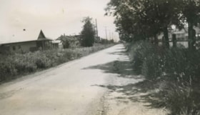
![Elgin Avenue, [193-] (date of original), copied 1986 thumbnail](/media/hpo/_Data/_Archives_Images/_Unrestricted/126/179-004.jpg?width=280)
Elgin Avenue
https://search.heritageburnaby.ca/link/archivedescription35033
- Repository
- City of Burnaby Archives
- Date
- [193-] (date of original), copied 1986
- Collection/Fonds
- Burnaby Historical Society fonds
- Description Level
- Item
- Physical Description
- 1 photograph : b&w ; 8.8 x 12.7 cm print
- Scope and Content
- Photograph of Elgin Avenue looking North from a farm at 6389 Elgin Avenue. Trees and brush line the road.
- Repository
- City of Burnaby Archives
- Date
- [193-] (date of original), copied 1986
- Collection/Fonds
- Burnaby Historical Society fonds
- Subseries
- Chamberlain family subseries
- Physical Description
- 1 photograph : b&w ; 8.8 x 12.7 cm print
- Description Level
- Item
- Record No.
- 179-004
- Access Restriction
- No restrictions
- Reproduction Restriction
- No known restrictions
- Accession Number
- BHS1986-27
- Scope and Content
- Photograph of Elgin Avenue looking North from a farm at 6389 Elgin Avenue. Trees and brush line the road.
- Subjects
- Geographic Features - Roads
- Media Type
- Photograph
- Notes
- Title based on contents of photograph
- Geographic Access
- Elgin Avenue
- Street Address
- 6389 Elgin Avenue
- Historic Neighbourhood
- Central Park (Historic Neighbourhood)
- Planning Study Area
- Windsor Area
Images
![Elgin Avenue, [193-] (date of original), copied 1986 thumbnail](/media/hpo/_Data/_Archives_Images/_Unrestricted/126/179-004.jpg)
![Gaglardi Way motor vehicle accident, [2002] thumbnail](/media/hpo/_Data/_Archives_Images/_Unrestricted/535/535-2918.jpg?width=280)
Gaglardi Way motor vehicle accident
https://search.heritageburnaby.ca/link/archivedescription97602
- Repository
- City of Burnaby Archives
- Date
- [2002]
- Collection/Fonds
- Burnaby NewsLeader photograph collection
- Description Level
- Item
- Physical Description
- 1 photograph (tiff) : col.
- Scope and Content
- Photograph of an overturned truck trailer after a motor vehicle accident at the Gaglardi Way on-ramp to Highway 1. A firefighter is approaching the trailer with a set of pliers and a traffic jam is visible on the highway in the background.
- Repository
- City of Burnaby Archives
- Date
- [2002]
- Collection/Fonds
- Burnaby NewsLeader photograph collection
- Physical Description
- 1 photograph (tiff) : col.
- Description Level
- Item
- Record No.
- 535-2918
- Access Restriction
- No restrictions
- Reproduction Restriction
- No restrictions
- Accession Number
- 2018-12
- Scope and Content
- Photograph of an overturned truck trailer after a motor vehicle accident at the Gaglardi Way on-ramp to Highway 1. A firefighter is approaching the trailer with a set of pliers and a traffic jam is visible on the highway in the background.
- Media Type
- Photograph
- Photographer
- Bartel, Mario
- Notes
- Title based on caption
- Collected by editorial for use in a January 2002 issue of the Burnaby NewsLeader
- Caption from metadata: "Traffic on the eastbound 401 is snarled as Burnaby firefighters clean up liquid amonia spilled when a truck trailer overturned at the Gagliardi on-ramp Thursday morning."
- Geographic Access
- Gaglardi Way
- Planning Study Area
- Burnaby Lake Area
Images
![Gaglardi Way motor vehicle accident, [2002] thumbnail](/media/hpo/_Data/_Archives_Images/_Unrestricted/535/535-2918.jpg)
![Gaglardi Way pedestrian overpass, [2005] thumbnail](/media/hpo/_Data/_Archives_Images/_Unrestricted/535/535-1858.jpg?width=280)
Gaglardi Way pedestrian overpass
https://search.heritageburnaby.ca/link/archivedescription96161
- Repository
- City of Burnaby Archives
- Date
- [2005]
- Collection/Fonds
- Burnaby NewsLeader photograph collection
- Description Level
- Item
- Physical Description
- 1 photograph (tiff) : col.
- Scope and Content
- Photograph of Alex Nemeth posing next to his truck and the pedestrian overpass on Gaglardi Way.
- Repository
- City of Burnaby Archives
- Date
- [2005]
- Collection/Fonds
- Burnaby NewsLeader photograph collection
- Physical Description
- 1 photograph (tiff) : col.
- Description Level
- Item
- Record No.
- 535-1858
- Access Restriction
- No restrictions
- Reproduction Restriction
- No restrictions
- Accession Number
- 2018-12
- Scope and Content
- Photograph of Alex Nemeth posing next to his truck and the pedestrian overpass on Gaglardi Way.
- Media Type
- Photograph
- Photographer
- Bartel, Mario
- Notes
- Title based on caption
- Collected by editorial for use in a January 2005 issue of the Burnaby NewsLeader
- Caption from metadata: "The windshield on Alex Nemeth's pickup truck was smashed on Tuesday when kids dropped snowballs filled with rocks from the pedestrian overpass on Gagliardi Way in Burnaby as he passed underneath on his way to work. The City of Burnaby has promised to enclose the walkway."
- Geographic Access
- Gaglardi Way
Images
![Gaglardi Way pedestrian overpass, [2005] thumbnail](/media/hpo/_Data/_Archives_Images/_Unrestricted/535/535-1858.jpg)

The Green Timbers
https://search.heritageburnaby.ca/link/archivedescription34299
- Repository
- City of Burnaby Archives
- Date
- 1923
- Collection/Fonds
- Burnaby Historical Society fonds
- Description Level
- Item
- Physical Description
- 1 photograph : b&w ; 12.2 x 7.5 cm on page 23.5 x 17.5 cm
- Scope and Content
- Photograph taken looking down a tree-lined road, and is labelled "The Green Timbers". An automobile is parked along the side of the road. The Green Timbers was a famous roadway that went through Surrey and by the 1920s it was known as the only remaining stretch of virgin forest all the way from Ca…
- Repository
- City of Burnaby Archives
- Date
- 1923
- Collection/Fonds
- Burnaby Historical Society fonds
- Subseries
- Peers family subseries
- Physical Description
- 1 photograph : b&w ; 12.2 x 7.5 cm on page 23.5 x 17.5 cm
- Description Level
- Item
- Record No.
- 020-006
- Access Restriction
- No restrictions
- Reproduction Restriction
- No known restrictions
- Accession Number
- BHS2007-04
- Scope and Content
- Photograph taken looking down a tree-lined road, and is labelled "The Green Timbers". An automobile is parked along the side of the road. The Green Timbers was a famous roadway that went through Surrey and by the 1920s it was known as the only remaining stretch of virgin forest all the way from California to British Columbia. In more recent years, this area in Surrey has been declared an urban forest park.
- Media Type
- Photograph
- Notes
- Title based on caption accompanying photograph
Images

![Jackson family, [1936 or 1937] (date of original), copied 1992 thumbnail](/media/hpo/_Data/_Archives_Images/_Unrestricted/315/315-093.jpg?width=280)
Jackson family
https://search.heritageburnaby.ca/link/archivedescription36738
- Repository
- City of Burnaby Archives
- Date
- [1936 or 1937] (date of original), copied 1992
- Collection/Fonds
- Burnaby Historical Society fonds
- Description Level
- Item
- Physical Description
- 1 photograph : b&w ; 8.4 x 12.2 cm print
- Scope and Content
- Photograph of Mrs. Florence Jackson, her children, Vera and Ron and their dog Dinty Moore who was part Alsatian and part Airedale, in the snow. This photograph was taken on Trafalgar Street (now Maywood) looking west toward Central Park from between Telford Avenue and McKay Avenue.
- Repository
- City of Burnaby Archives
- Date
- [1936 or 1937] (date of original), copied 1992
- Collection/Fonds
- Burnaby Historical Society fonds
- Subseries
- Burnaby Centennial Anthology subseries
- Physical Description
- 1 photograph : b&w ; 8.4 x 12.2 cm print
- Description Level
- Item
- Record No.
- 315-093
- Access Restriction
- No restrictions
- Reproduction Restriction
- No known restrictions
- Accession Number
- BHS1994-04
- Scope and Content
- Photograph of Mrs. Florence Jackson, her children, Vera and Ron and their dog Dinty Moore who was part Alsatian and part Airedale, in the snow. This photograph was taken on Trafalgar Street (now Maywood) looking west toward Central Park from between Telford Avenue and McKay Avenue.
- Media Type
- Photograph
- Notes
- Title based on contents of photograph
- Geographic Access
- Maywood Street
- McKay Avenue
- Central Park
- Historic Neighbourhood
- Central Park (Historic Neighbourhood)
- Planning Study Area
- Maywood Area
Images
![Jackson family, [1936 or 1937] (date of original), copied 1992 thumbnail](/media/hpo/_Data/_Archives_Images/_Unrestricted/315/315-093.jpg)
![Jackson family, [193-] (date of original), copied 1992 thumbnail](/media/hpo/_Data/_Archives_Images/_Unrestricted/315/315-094.jpg?width=280)
Jackson family
https://search.heritageburnaby.ca/link/archivedescription36739
- Repository
- City of Burnaby Archives
- Date
- [193-] (date of original), copied 1992
- Collection/Fonds
- Burnaby Historical Society fonds
- Description Level
- Item
- Physical Description
- 1 photograph : b&w ; 8.7 x 12.6 cm print
- Scope and Content
- Photograph of Mrs. Florence Jackson, her son Ron, and their dog Dinty Moore who was part Alsatian and part Airedale, in the snow.
- Repository
- City of Burnaby Archives
- Date
- [193-] (date of original), copied 1992
- Collection/Fonds
- Burnaby Historical Society fonds
- Subseries
- Burnaby Centennial Anthology subseries
- Physical Description
- 1 photograph : b&w ; 8.7 x 12.6 cm print
- Description Level
- Item
- Record No.
- 315-094
- Access Restriction
- No restrictions
- Reproduction Restriction
- No known restrictions
- Accession Number
- BHS1994-04
- Scope and Content
- Photograph of Mrs. Florence Jackson, her son Ron, and their dog Dinty Moore who was part Alsatian and part Airedale, in the snow.
- Media Type
- Photograph
- Notes
- Title based on contents of photograph
Images
![Jackson family, [193-] (date of original), copied 1992 thumbnail](/media/hpo/_Data/_Archives_Images/_Unrestricted/315/315-094.jpg)
![Jackson family, [193-] (date of original), copied 1992 thumbnail](/media/hpo/_Data/_Archives_Images/_Unrestricted/315/315-095.jpg?width=280)
Jackson family
https://search.heritageburnaby.ca/link/archivedescription36740
- Repository
- City of Burnaby Archives
- Date
- [193-] (date of original), copied 1992
- Collection/Fonds
- Burnaby Historical Society fonds
- Description Level
- Item
- Physical Description
- 1 photograph : b&w ; 8.1 x 12.0 cm print
- Scope and Content
- Photograph of sister and brother, Vera and Ron Jackson, in the snow.
- Repository
- City of Burnaby Archives
- Date
- [193-] (date of original), copied 1992
- Collection/Fonds
- Burnaby Historical Society fonds
- Subseries
- Burnaby Centennial Anthology subseries
- Physical Description
- 1 photograph : b&w ; 8.1 x 12.0 cm print
- Description Level
- Item
- Record No.
- 315-095
- Access Restriction
- No restrictions
- Reproduction Restriction
- No known restrictions
- Accession Number
- BHS1994-04
- Scope and Content
- Photograph of sister and brother, Vera and Ron Jackson, in the snow.
- Media Type
- Photograph
- Notes
- Title based on contents of photograph
Images
![Jackson family, [193-] (date of original), copied 1992 thumbnail](/media/hpo/_Data/_Archives_Images/_Unrestricted/315/315-095.jpg)

Kingsway 1939
https://search.heritageburnaby.ca/link/archivedescription55592
- Repository
- City of Burnaby Archives
- Date
- 1939
- Collection/Fonds
- John Shaw fonds
- Description Level
- Item
- Physical Description
- 1 photograph : b&w ; 6.5 x 9 cm
- Scope and Content
- Photograph of a large crowd gathered outside the Municipal Hall on Kingsway. This photograph was taken during the visit of King George VI and Queen Elizabeth in 1939. A large group of spectators can be seen standing on either side of the street.
- Repository
- City of Burnaby Archives
- Date
- 1939
- Collection/Fonds
- John Shaw fonds
- Series
- Civil Service series
- Physical Description
- 1 photograph : b&w ; 6.5 x 9 cm
- Description Level
- Item
- Record No.
- 485-067
- Access Restriction
- No restrictions
- Reproduction Restriction
- No known restrictions
- Accession Number
- 2005-15
- 2006-01
- 2007-18
- Scope and Content
- Photograph of a large crowd gathered outside the Municipal Hall on Kingsway. This photograph was taken during the visit of King George VI and Queen Elizabeth in 1939. A large group of spectators can be seen standing on either side of the street.
- Names
- Burnaby City Hall
- Media Type
- Photograph
- Notes
- Title based on contents of photograph
- Geographic Access
- Kingsway
- Street Address
- 7282 Kingsway
- Historic Neighbourhood
- Edmonds (Historic Neighbourhood)
- Planning Study Area
- Stride Avenue Area
Images

![Kingsway & Edmonds plans, [2002] thumbnail](/media/hpo/_Data/_Archives_Images/_Unrestricted/535/535-2312.jpg?width=280)
Kingsway & Edmonds plans
https://search.heritageburnaby.ca/link/archivedescription96707
- Repository
- City of Burnaby Archives
- Date
- [2002]
- Collection/Fonds
- Burnaby NewsLeader photograph collection
- Description Level
- Item
- Physical Description
- 1 photograph (tiff) : col.
- Scope and Content
- Photograph of an unidentified man standing on a street corner at Edmonds & Kingsway and reviewing a set of City of Burnaby Engineering Department plans. A home building store is visible across the intersection in the background.
- Repository
- City of Burnaby Archives
- Date
- [2002]
- Collection/Fonds
- Burnaby NewsLeader photograph collection
- Physical Description
- 1 photograph (tiff) : col.
- Description Level
- Item
- Record No.
- 535-2312
- Access Restriction
- No restrictions
- Reproduction Restriction
- No restrictions
- Accession Number
- 2018-12
- Scope and Content
- Photograph of an unidentified man standing on a street corner at Edmonds & Kingsway and reviewing a set of City of Burnaby Engineering Department plans. A home building store is visible across the intersection in the background.
- Media Type
- Photograph
- Notes
- Title based on contents of photograph
- Collected by editorial for use in a March 2002 issue of the Burnaby NewsLeader
- Geographic Access
- Kingsway
- Edmonds Street
- Historic Neighbourhood
- Edmonds (Historic Neighbourhood)
- Planning Study Area
- Edmonds Area
Images
![Kingsway & Edmonds plans, [2002] thumbnail](/media/hpo/_Data/_Archives_Images/_Unrestricted/535/535-2312.jpg)
McKay Avenue
https://search.heritageburnaby.ca/link/archivedescription36431
- Repository
- City of Burnaby Archives
- Date
- 1932
- Collection/Fonds
- Burnaby Historical Society fonds
- Description Level
- Item
- Physical Description
- 1 photograph : sepia ; 6 x 10.5 cm
- Scope and Content
- Photograph of McKay Avenue with long grass and flowering trees bordering the roadway.
- Repository
- City of Burnaby Archives
- Date
- 1932
- Collection/Fonds
- Burnaby Historical Society fonds
- Subseries
- Martin family subseries
- Physical Description
- 1 photograph : sepia ; 6 x 10.5 cm
- Description Level
- Item
- Record No.
- 270-003
- Access Restriction
- No restrictions
- Reproduction Restriction
- No known restrictions
- Accession Number
- BHS1991-39
- Scope and Content
- Photograph of McKay Avenue with long grass and flowering trees bordering the roadway.
- Subjects
- Geographic Features - Roads
- Media Type
- Photograph
- Notes
- Title based on contents of photograph
- Geographic Access
- McKay Avenue
- Historic Neighbourhood
- Central Park (Historic Neighbourhood)
- Planning Study Area
- Maywood Area
Images
