Narrow Results By
Subject
- Advertising Medium - Signs and Signboards 2
- Aerial Photographs 1
- Buildings - Commercial 1
- Buildings - Industrial - Mills 1
- Buildings - Residential - Houses 4
- Buildings - Residential - Seniors Housing 1
- Construction 1
- Geographic Features - Inlets 1
- Geographic Features - Mountains 1
- Geographic Features - Roads 27
- Geographic Features - Sidewalks 1
- Land Clearing 1
![1000 Block Gilley Avenue, [1955] (date of original), copied 1991 thumbnail](/media/hpo/_Data/_Archives_Images/_Unrestricted/370/370-672.jpg?width=280)
1000 Block Gilley Avenue
https://search.heritageburnaby.ca/link/archivedescription38085
- Repository
- City of Burnaby Archives
- Date
- [1955] (date of original), copied 1991
- Collection/Fonds
- Burnaby Historical Society fonds
- Description Level
- Item
- Physical Description
- 1 photograph : b&w ; 3.1 x 3.0 cm print on contact sheet 21.5 x 26.8 cm
- Scope and Content
- Photograph of the 1000 block of Gilley Avenue (later renumbered the 8000 block) looking south towards Marine Drive in the snow.
- Repository
- City of Burnaby Archives
- Date
- [1955] (date of original), copied 1991
- Collection/Fonds
- Burnaby Historical Society fonds
- Subseries
- Burnaby Image Bank subseries
- Physical Description
- 1 photograph : b&w ; 3.1 x 3.0 cm print on contact sheet 21.5 x 26.8 cm
- Description Level
- Item
- Record No.
- 370-672
- Access Restriction
- No restrictions
- Reproduction Restriction
- No restrictions
- Accession Number
- BHS1999-03
- Scope and Content
- Photograph of the 1000 block of Gilley Avenue (later renumbered the 8000 block) looking south towards Marine Drive in the snow.
- Media Type
- Photograph
- Notes
- Title based on contents of photograph
- 1 b&w copy negative accompanying
- Negative has a pink cast
- Geographic Access
- Gilley Avenue
- Planning Study Area
- Clinton-Glenwood Area
- Stride Hill Area
Images
![1000 Block Gilley Avenue, [1955] (date of original), copied 1991 thumbnail](/media/hpo/_Data/_Archives_Images/_Unrestricted/370/370-672.jpg)

Barnet Road
https://search.heritageburnaby.ca/link/archivedescription35634
- Repository
- City of Burnaby Archives
- Date
- 1922 (date of original), copied 1986
- Collection/Fonds
- Burnaby Historical Society fonds
- Description Level
- Item
- Physical Description
- 1 photograph : b&w ; 12.7 x 17.8 cm print
- Scope and Content
- Photograph of Robert Woolsey carrying his daughter, Margaret, piggy-back along Barnet Road. Note the planked surface. Margaret was two years old at the time. In the upper right corner of the photograph is the Barnet School caretaker's cottage, located beside Barnet School at 7820 Barnet Road.
- Repository
- City of Burnaby Archives
- Date
- 1922 (date of original), copied 1986
- Collection/Fonds
- Burnaby Historical Society fonds
- Subseries
- Pioneer Tales subseries
- Physical Description
- 1 photograph : b&w ; 12.7 x 17.8 cm print
- Description Level
- Item
- Record No.
- 204-492
- Access Restriction
- No restrictions
- Reproduction Restriction
- No known restrictions
- Accession Number
- BHS1988-03
- Scope and Content
- Photograph of Robert Woolsey carrying his daughter, Margaret, piggy-back along Barnet Road. Note the planked surface. Margaret was two years old at the time. In the upper right corner of the photograph is the Barnet School caretaker's cottage, located beside Barnet School at 7820 Barnet Road.
- Subjects
- Geographic Features - Roads
- Media Type
- Photograph
- Notes
- Title based on contents of photograph
- Geographic Access
- Barnet Road
- Street Address
- 7820 Barnet Road
- Historic Neighbourhood
- Barnet (Historic Neighbourhood)
- Planning Study Area
- Burnaby Mountain Area
Images


Barnet Road
https://search.heritageburnaby.ca/link/archivedescription35635
- Repository
- City of Burnaby Archives
- Date
- 1921 (date of original), copied 1986
- Collection/Fonds
- Burnaby Historical Society fonds
- Description Level
- Item
- Physical Description
- 1 photograph : b&w ; 12.7 x 17.8 cm print
- Scope and Content
- Photograph of Barnet Road covered with November snows. The road was always treacherous in winter with snow and rock slides. In the upper right corner of the photograph is Barnet School and caretaker's cottage. Barnet School was located at 7820 Barnet Road.
- Repository
- City of Burnaby Archives
- Date
- 1921 (date of original), copied 1986
- Collection/Fonds
- Burnaby Historical Society fonds
- Subseries
- Pioneer Tales subseries
- Physical Description
- 1 photograph : b&w ; 12.7 x 17.8 cm print
- Description Level
- Item
- Record No.
- 204-493
- Access Restriction
- No restrictions
- Reproduction Restriction
- No known restrictions
- Accession Number
- BHS1988-03
- Scope and Content
- Photograph of Barnet Road covered with November snows. The road was always treacherous in winter with snow and rock slides. In the upper right corner of the photograph is Barnet School and caretaker's cottage. Barnet School was located at 7820 Barnet Road.
- Names
- Barnet School
- Media Type
- Photograph
- Notes
- Title based on contents of photograph
- Geographic Access
- Barnet Road
- Street Address
- 7820 Barnet Road
- Historic Neighbourhood
- Barnet (Historic Neighbourhood)
- Planning Study Area
- Burnaby Mountain Area
Images


Bill Lewarne
https://search.heritageburnaby.ca/link/archivedescription35197
- Repository
- City of Burnaby Archives
- Date
- 1929 (date of original), copied 1986
- Collection/Fonds
- Burnaby Historical Society fonds
- Description Level
- Item
- Physical Description
- 1 photograph : b&w ; 12.7 x 17.8 cm print
- Scope and Content
- Photograph of young Bill (William) Lewarne in front of his grandparents' home, at Portland Street and McGregor Avenue. Bill Lewarne went on to become the Mayor of Burnaby, serving from 1981 to 1987. He also served as a member of Council from 1973 to 1975 and 1977 to 1981.
- Repository
- City of Burnaby Archives
- Date
- 1929 (date of original), copied 1986
- Collection/Fonds
- Burnaby Historical Society fonds
- Subseries
- Pioneer Tales subseries
- Physical Description
- 1 photograph : b&w ; 12.7 x 17.8 cm print
- Description Level
- Item
- Record No.
- 204-054
- Access Restriction
- No restrictions
- Reproduction Restriction
- No known restrictions
- Accession Number
- BHS1988-03
- Scope and Content
- Photograph of young Bill (William) Lewarne in front of his grandparents' home, at Portland Street and McGregor Avenue. Bill Lewarne went on to become the Mayor of Burnaby, serving from 1981 to 1987. He also served as a member of Council from 1973 to 1975 and 1977 to 1981.
- Media Type
- Photograph
- Notes
- Title based on contents of photograph
Images

![Boundary Road and Kingsway, [1959] thumbnail](/media/Hpo/_Data/_Archives_Images/_Unrestricted/001/113-001.jpg?width=280)
Boundary Road and Kingsway
https://search.heritageburnaby.ca/link/archivedescription34709
- Repository
- City of Burnaby Archives
- Date
- [1959]
- Collection/Fonds
- Burnaby Historical Society fonds
- Description Level
- Item
- Physical Description
- 1 photograph : b&w ; 16.0 x 25.3 cm
- Scope and Content
- Photograph of buildings at Boundary Road and Kingsway, southwest corner. A typed description on the back of the photograph reads, "The new Hemlock (automatic) and old Dexter (manual) exchanges. / B.C. Telephone Company."
- Repository
- City of Burnaby Archives
- Date
- [1959]
- Collection/Fonds
- Burnaby Historical Society fonds
- Subseries
- Photographs subseries
- Physical Description
- 1 photograph : b&w ; 16.0 x 25.3 cm
- Description Level
- Item
- Record No.
- 113-001
- Access Restriction
- No restrictions
- Reproduction Restriction
- Reproduce for fair dealing purposes only
- Accession Number
- BHS2007-04
- Scope and Content
- Photograph of buildings at Boundary Road and Kingsway, southwest corner. A typed description on the back of the photograph reads, "The new Hemlock (automatic) and old Dexter (manual) exchanges. / B.C. Telephone Company."
- Media Type
- Photograph
- Photographer
- Williams Brothers Photographers Limited
- Notes
- Title based on contents of photograph
- Stamp on back of photograph reads, "Williams Bros. Photographers Ltd. / 413 Granville St. Vancouver 2, B.C. / Phone Tatlow 8588"
- Geographic Access
- Boundary Road
- Kingsway
- Historic Neighbourhood
- Central Park (Historic Neighbourhood)
- Planning Study Area
- Garden Village Area
Images
![Boundary Road and Kingsway, [1959] thumbnail](/media/Hpo/_Data/_Archives_Images/_Unrestricted/001/113-001.jpg)

Frank Warburton
https://search.heritageburnaby.ca/link/archivedescription35915
- Repository
- City of Burnaby Archives
- Date
- 1928 (date of original), copied 1986
- Collection/Fonds
- Burnaby Historical Society fonds
- Description Level
- Item
- Physical Description
- 1 photograph : b&w ; 12.7 x 17.8 cm print
- Scope and Content
- Photograph of Frank Warburton painting white lines along Kingsway.
- Repository
- City of Burnaby Archives
- Date
- 1928 (date of original), copied 1986
- Collection/Fonds
- Burnaby Historical Society fonds
- Subseries
- Pioneer Tales subseries
- Physical Description
- 1 photograph : b&w ; 12.7 x 17.8 cm print
- Description Level
- Item
- Record No.
- 204-774
- Access Restriction
- No restrictions
- Reproduction Restriction
- No known restrictions
- Accession Number
- BHS1988-03
- Scope and Content
- Photograph of Frank Warburton painting white lines along Kingsway.
- Names
- Warburton, Frank
- Media Type
- Photograph
- Notes
- Title based on contents of photograph
- Geographic Access
- Kingsway
Images

![Freeway at the Willingdon Avenue exit, [1955] thumbnail](/media/hpo/_Data/_Archives_Images/_Unrestricted/480/480-283.jpg?width=280)
Freeway at the Willingdon Avenue exit
https://search.heritageburnaby.ca/link/archivedescription45388
- Repository
- City of Burnaby Archives
- Date
- [1955]
- Collection/Fonds
- Columbian Newspaper collection
- Description Level
- Item
- Physical Description
- 1 photograph : b&w ; 20 x 24.5 cm
- Scope and Content
- Photograph of the Freeway, now named the Trans Canada Highway, near the Willingdon Avenue exit.
- Repository
- City of Burnaby Archives
- Date
- [1955]
- Collection/Fonds
- Columbian Newspaper collection
- Physical Description
- 1 photograph : b&w ; 20 x 24.5 cm
- Description Level
- Item
- Record No.
- 480-283
- Access Restriction
- No restrictions
- Reproduction Restriction
- No restrictions
- Accession Number
- 2003-02
- Scope and Content
- Photograph of the Freeway, now named the Trans Canada Highway, near the Willingdon Avenue exit.
- Subjects
- Geographic Features - Roads
- Media Type
- Photograph
- Photographer
- British Columbia Government Photograph
- Notes
- Title based on contents of photograph
- Photographer identifies photograph as no. H - 1869
- Geographic Access
- Trans Canada Highway
- Willingdon Avenue
- Historic Neighbourhood
- Broadview (Historic Neighbourhood)
- Planning Study Area
- Cascade-Schou Area
Images
![Freeway at the Willingdon Avenue exit, [1955] thumbnail](/media/hpo/_Data/_Archives_Images/_Unrestricted/480/480-283.jpg)

Government Road
https://search.heritageburnaby.ca/link/archivedescription35569
- Repository
- City of Burnaby Archives
- Date
- 1925 (date of original), copied 1986
- Collection/Fonds
- Burnaby Historical Society fonds
- Description Level
- Item
- Physical Description
- 1 photograph : b&w ; 12.7 x 17.8 cm print
- Scope and Content
- Photograph of Government Road in front of the Haddon family house at 7870 Government Road. Note the bushland and rough road surface.
- Repository
- City of Burnaby Archives
- Date
- 1925 (date of original), copied 1986
- Collection/Fonds
- Burnaby Historical Society fonds
- Subseries
- Pioneer Tales subseries
- Physical Description
- 1 photograph : b&w ; 12.7 x 17.8 cm print
- Description Level
- Item
- Record No.
- 204-427
- Access Restriction
- No restrictions
- Reproduction Restriction
- No known restrictions
- Accession Number
- BHS1988-03
- Scope and Content
- Photograph of Government Road in front of the Haddon family house at 7870 Government Road. Note the bushland and rough road surface.
- Subjects
- Geographic Features - Roads
- Media Type
- Photograph
- Notes
- Title based on contents of photograph
- Geographic Access
- Government Road
- Historic Neighbourhood
- Lozells (Historic Neighbourhood)
- Planning Study Area
- Government Road Area
Images


The Green Timbers
https://search.heritageburnaby.ca/link/archivedescription34299
- Repository
- City of Burnaby Archives
- Date
- 1923
- Collection/Fonds
- Burnaby Historical Society fonds
- Description Level
- Item
- Physical Description
- 1 photograph : b&w ; 12.2 x 7.5 cm on page 23.5 x 17.5 cm
- Scope and Content
- Photograph taken looking down a tree-lined road, and is labelled "The Green Timbers". An automobile is parked along the side of the road. The Green Timbers was a famous roadway that went through Surrey and by the 1920s it was known as the only remaining stretch of virgin forest all the way from Ca…
- Repository
- City of Burnaby Archives
- Date
- 1923
- Collection/Fonds
- Burnaby Historical Society fonds
- Subseries
- Peers family subseries
- Physical Description
- 1 photograph : b&w ; 12.2 x 7.5 cm on page 23.5 x 17.5 cm
- Description Level
- Item
- Record No.
- 020-006
- Access Restriction
- No restrictions
- Reproduction Restriction
- No known restrictions
- Accession Number
- BHS2007-04
- Scope and Content
- Photograph taken looking down a tree-lined road, and is labelled "The Green Timbers". An automobile is parked along the side of the road. The Green Timbers was a famous roadway that went through Surrey and by the 1920s it was known as the only remaining stretch of virgin forest all the way from California to British Columbia. In more recent years, this area in Surrey has been declared an urban forest park.
- Media Type
- Photograph
- Notes
- Title based on caption accompanying photograph
Images


The Green Timbers
https://search.heritageburnaby.ca/link/archivedescription34300
- Repository
- City of Burnaby Archives
- Date
- 1923
- Collection/Fonds
- Burnaby Historical Society fonds
- Description Level
- Item
- Physical Description
- 1 photograph : b&w ; 12.2 x 7.5 cm on page 23.5 x 17.5 cm
- Scope and Content
- Photograph is labelled "The Green Timbers" and shows a view looking down a tree-line road. The Green Timbers was a famous roadway that went through Surrey and by the 1920s it was known as the only remaining stretch of virgin forest all the way from California to British Columbia. In more recent ye…
- Repository
- City of Burnaby Archives
- Date
- 1923
- Collection/Fonds
- Burnaby Historical Society fonds
- Subseries
- Peers family subseries
- Physical Description
- 1 photograph : b&w ; 12.2 x 7.5 cm on page 23.5 x 17.5 cm
- Description Level
- Item
- Record No.
- 020-007
- Access Restriction
- No restrictions
- Reproduction Restriction
- No known restrictions
- Accession Number
- BHS2007-04
- Scope and Content
- Photograph is labelled "The Green Timbers" and shows a view looking down a tree-line road. The Green Timbers was a famous roadway that went through Surrey and by the 1920s it was known as the only remaining stretch of virgin forest all the way from California to British Columbia. In more recent years, this area in Surrey has been declared an urban forest park.
- Media Type
- Photograph
- Notes
- Title based on caption accompanying photograph
Images


Kingsway
https://search.heritageburnaby.ca/link/archivedescription34510
- Repository
- City of Burnaby Archives
- Date
- 1920
- Collection/Fonds
- Burnaby Historical Society fonds
- Description Level
- Item
- Physical Description
- 1 photograph : sepia ; 12.6 x 17.7 cm
- Scope and Content
- Photograph of Kingsway looking east at Boundary Road. A sign on the right reads, "Burnaby / Vehicles must slow down at all schools and intersections marked thus: X." A sign on a building at the left reads, "Arctic Ice Cream." Central Park is on the right.
- Repository
- City of Burnaby Archives
- Date
- 1920
- Collection/Fonds
- Burnaby Historical Society fonds
- Subseries
- Photographs subseries
- Physical Description
- 1 photograph : sepia ; 12.6 x 17.7 cm
- Description Level
- Item
- Record No.
- 031-001
- Access Restriction
- No restrictions
- Reproduction Restriction
- No known restrictions
- Accession Number
- BHS2007-04
- Scope and Content
- Photograph of Kingsway looking east at Boundary Road. A sign on the right reads, "Burnaby / Vehicles must slow down at all schools and intersections marked thus: X." A sign on a building at the left reads, "Arctic Ice Cream." Central Park is on the right.
- Media Type
- Photograph
- Notes
- Title based on contents of photograph
- Geographic Access
- Kingsway
- Central Park
- Boundary Road
- Historic Neighbourhood
- Central Park (Historic Neighbourhood)
- Planning Study Area
- Garden Village Area
- Maywood Area
Images


Kingsway
https://search.heritageburnaby.ca/link/archivedescription34511
- Repository
- City of Burnaby Archives
- Date
- 1920
- Collection/Fonds
- Burnaby Historical Society fonds
- Description Level
- Item
- Physical Description
- 1 photograph : sepia ; 12.6 x 17.6 cm
- Scope and Content
- Photograph of Kingsway looking east at Boundary Road. A sign on the right reads, "Burnaby / Vehicles must slow down at all schools and intersections marked thus: X." A sign on a building at the left reads, "Arctic Ice Cream." Central Park is on the right.
- Repository
- City of Burnaby Archives
- Date
- 1920
- Collection/Fonds
- Burnaby Historical Society fonds
- Subseries
- Photographs subseries
- Physical Description
- 1 photograph : sepia ; 12.6 x 17.6 cm
- Description Level
- Item
- Record No.
- 031-002
- Access Restriction
- No restrictions
- Reproduction Restriction
- No known restrictions
- Accession Number
- BHS2007-04
- Scope and Content
- Photograph of Kingsway looking east at Boundary Road. A sign on the right reads, "Burnaby / Vehicles must slow down at all schools and intersections marked thus: X." A sign on a building at the left reads, "Arctic Ice Cream." Central Park is on the right.
- Subjects
- Geographic Features - Roads
- Advertising Medium - Signs and Signboards
- Transportation - Automobiles
- Media Type
- Photograph
- Notes
- Title based on contents of photograph
- Geographic Access
- Kingsway
- Central Park
- Boundary Road
- Historic Neighbourhood
- Central Park (Historic Neighbourhood)
- Planning Study Area
- Garden Village Area
- Maywood Area
Images


Kingsway
https://search.heritageburnaby.ca/link/archivedescription39788
- Repository
- City of Burnaby Archives
- Date
- 1920
- Collection/Fonds
- Burnaby Historical Society fonds
- Description Level
- Item
- Physical Description
- 1 photograph : sepia ; 12.6 x 17.7 cm
- Scope and Content
- Photograph of Kingsway looking east, including automobiles, a motorcycle with side car, and the Sharp Service Station on the right at 4160 Kingsway (later renumbered as the 4300 block of Kingsway).
- Repository
- City of Burnaby Archives
- Date
- 1920
- Collection/Fonds
- Burnaby Historical Society fonds
- Subseries
- Photographs subseries
- Physical Description
- 1 photograph : sepia ; 12.6 x 17.7 cm
- Description Level
- Item
- Record No.
- 031-003
- Access Restriction
- No restrictions
- Reproduction Restriction
- No known restrictions
- Accession Number
- BHS2007-04
- Scope and Content
- Photograph of Kingsway looking east, including automobiles, a motorcycle with side car, and the Sharp Service Station on the right at 4160 Kingsway (later renumbered as the 4300 block of Kingsway).
- Subjects
- Geographic Features - Roads
- Media Type
- Photograph
- Notes
- Title based on contents of photograph
- Geographic Access
- Kingsway
- Historic Neighbourhood
- Central Park (Historic Neighbourhood)
- Planning Study Area
- Maywood Area
Images

![Mary Warren and Bill Anthony, [192-] (date of original), copied 1986 thumbnail](/media/hpo/_Data/_Archives_Images/_Unrestricted/204/204-404.jpg?width=280)
Mary Warren and Bill Anthony
https://search.heritageburnaby.ca/link/archivedescription35546
- Repository
- City of Burnaby Archives
- Date
- [192-] (date of original), copied 1986
- Collection/Fonds
- Burnaby Historical Society fonds
- Description Level
- Item
- Physical Description
- 1 photograph : b&w ; 12.7 x 17.8 cm print
- Scope and Content
- Photograph of Mary Warren and Bill Anthony, west of the Warren family home at 4264 Union Street. The street did not extend past the Warren house. A "corduroy" road was used in the early years: split cedar logs placed side by side.
- Repository
- City of Burnaby Archives
- Date
- [192-] (date of original), copied 1986
- Collection/Fonds
- Burnaby Historical Society fonds
- Subseries
- Pioneer Tales subseries
- Physical Description
- 1 photograph : b&w ; 12.7 x 17.8 cm print
- Description Level
- Item
- Record No.
- 204-404
- Access Restriction
- No restrictions
- Reproduction Restriction
- No known restrictions
- Accession Number
- BHS1988-03
- Scope and Content
- Photograph of Mary Warren and Bill Anthony, west of the Warren family home at 4264 Union Street. The street did not extend past the Warren house. A "corduroy" road was used in the early years: split cedar logs placed side by side.
- Media Type
- Photograph
- Notes
- Title based on contents of photograph
- Geographic Access
- Union Street
- Street Address
- 4264 Union Street
- Historic Neighbourhood
- Vancouver Heights (Historic Neighbourhood)
- Planning Study Area
- Willingdon Heights Area
Images
![Mary Warren and Bill Anthony, [192-] (date of original), copied 1986 thumbnail](/media/hpo/_Data/_Archives_Images/_Unrestricted/204/204-404.jpg)
![Mundell's Store and Capitol Hill School playground, [1928] (date of original), copied 1991 thumbnail](/media/hpo/_Data/_Archives_Images/_Unrestricted/370/370-066.jpg?width=280)
Mundell's Store and Capitol Hill School playground
https://search.heritageburnaby.ca/link/archivedescription37478
- Repository
- City of Burnaby Archives
- Date
- [1928] (date of original), copied 1991
- Collection/Fonds
- Burnaby Historical Society fonds
- Description Level
- Item
- Physical Description
- 1 photograph : b&w ; 2.9 x 5.0 cm print on contact sheet 20.2 x 25.3 cm
- Scope and Content
- Photograph of the northeast corner of Warwick Avenue and Hastings Street, including Mundell's store and the Capitol Hill School playground.
- Repository
- City of Burnaby Archives
- Date
- [1928] (date of original), copied 1991
- Collection/Fonds
- Burnaby Historical Society fonds
- Subseries
- Burnaby Image Bank subseries
- Physical Description
- 1 photograph : b&w ; 2.9 x 5.0 cm print on contact sheet 20.2 x 25.3 cm
- Description Level
- Item
- Record No.
- 370-066
- Access Restriction
- No restrictions
- Reproduction Restriction
- No known restrictions
- Accession Number
- BHS1999-03
- Scope and Content
- Photograph of the northeast corner of Warwick Avenue and Hastings Street, including Mundell's store and the Capitol Hill School playground.
- Media Type
- Photograph
- Notes
- Title based on contents of photograph
- 1 b&w copy negative accompanying
- Geographic Access
- Warwick Avenue
- Hastings Street
- Historic Neighbourhood
- Capitol Hill (Historic Neighbourhood)
- Planning Study Area
- Capitol Hill Area
Images
![Mundell's Store and Capitol Hill School playground, [1928] (date of original), copied 1991 thumbnail](/media/hpo/_Data/_Archives_Images/_Unrestricted/370/370-066.jpg)

New Freeway in Burnaby
https://search.heritageburnaby.ca/link/archivedescription45383
- Repository
- City of Burnaby Archives
- Date
- 1959
- Collection/Fonds
- Columbian Newspaper collection
- Description Level
- Item
- Physical Description
- 1 photograph : b&w ; 20.5 x 18.5 cm
- Scope and Content
- Photograph of the Lower mainland's "new freeway" in Burnaby. This was taken along the Trans Canada Highway with the Willingdon exit off to the south and the Grandview Highway off to the west.
- Repository
- City of Burnaby Archives
- Date
- 1959
- Collection/Fonds
- Columbian Newspaper collection
- Physical Description
- 1 photograph : b&w ; 20.5 x 18.5 cm
- Description Level
- Item
- Record No.
- 480-278
- Access Restriction
- No restrictions
- Reproduction Restriction
- No restrictions
- Accession Number
- 2003-02
- Scope and Content
- Photograph of the Lower mainland's "new freeway" in Burnaby. This was taken along the Trans Canada Highway with the Willingdon exit off to the south and the Grandview Highway off to the west.
- Subjects
- Geographic Features - Roads
- Media Type
- Photograph
- Photographer
- King, Basil
- Notes
- Title based on note on verso of photograph
- Note on verso of photograph reads: "Lower mainland's new freeway in Burnaby"
- Geographic Access
- Trans Canada Highway
- Historic Neighbourhood
- Broadview (Historic Neighbourhood)
- Planning Study Area
- Cascade-Schou Area
Images

![New Vista Society Housing Projects, [between 1949 and 1957] thumbnail](/media/hpo/_Data/_Archives_Images/_Unrestricted/513/514-013.jpg?width=280)
New Vista Society Housing Projects
https://search.heritageburnaby.ca/link/archivedescription64687
- Repository
- City of Burnaby Archives
- Date
- [between 1949 and 1957]
- Collection/Fonds
- Ernest Winch fonds
- Description Level
- Item
- Physical Description
- 1 photograph : b&w postcard ; 8 x 13 cm
- Scope and Content
- Photographic postcard of an unpaved road lined with New Vista Society Housing Projects.
- Repository
- City of Burnaby Archives
- Date
- [between 1949 and 1957]
- Collection/Fonds
- Ernest Winch fonds
- Physical Description
- 1 photograph : b&w postcard ; 8 x 13 cm
- Description Level
- Item
- Record No.
- 514-013
- Access Restriction
- No restrictions
- Reproduction Restriction
- Reproduce for fair dealing purposes only
- Accession Number
- 2010-06
- Scope and Content
- Photographic postcard of an unpaved road lined with New Vista Society Housing Projects.
- Names
- New Vista Society
- Media Type
- Photograph
- Notes
- Title based on contents of photograph
- Handwritten in border of photograph: "1-2-3"
Images
![New Vista Society Housing Projects, [between 1949 and 1957] thumbnail](/media/hpo/_Data/_Archives_Images/_Unrestricted/513/514-013.jpg)
![North Burnaby, [1959] thumbnail](/media/hpo/_Data/_Archives_Images/_Unrestricted/001/106-001.jpg?width=280)
North Burnaby
https://search.heritageburnaby.ca/link/archivedescription34701
- Repository
- City of Burnaby Archives
- Date
- [1959]
- Collection/Fonds
- Burnaby Historical Society fonds
- Description Level
- Item
- Physical Description
- 1 photograph : b&w ; 16.6 x 20.5 cm
- Scope and Content
- Aerial photograph of North Burnaby and Burrard Inlet looking west.
- Repository
- City of Burnaby Archives
- Date
- [1959]
- Collection/Fonds
- Burnaby Historical Society fonds
- Subseries
- Photographs subseries
- Physical Description
- 1 photograph : b&w ; 16.6 x 20.5 cm
- Description Level
- Item
- Record No.
- 106-001
- Access Restriction
- No restrictions
- Reproduction Restriction
- Reproduce for fair dealing purposes only
- Accession Number
- BHS2007-04
- Scope and Content
- Aerial photograph of North Burnaby and Burrard Inlet looking west.
- Media Type
- Photograph
- Notes
- Title based on contents of photograph
- Historic Neighbourhood
- Vancouver Heights (Historic Neighbourhood)
- Capitol Hill (Historic Neighbourhood)
- Lochdale (Historic Neighbourhood)
- Planning Study Area
- Burnaby Heights Area
- Capitol Hill Area
- Westridge Area
- Willingdon Heights Area
- Brentwood Area
- Parkcrest-Aubrey Area
- Lochdale Area
Images
![North Burnaby, [1959] thumbnail](/media/hpo/_Data/_Archives_Images/_Unrestricted/001/106-001.jpg)

Opening of the Hastings-Barnet Road
https://search.heritageburnaby.ca/link/archivedescription38660
- Repository
- City of Burnaby Archives
- Date
- 1927
- Collection/Fonds
- Burnaby Historical Society fonds
- Description Level
- Item
- Physical Description
- 1 photograph : sepia ; 17.5 x 26.5 cm
- Scope and Content
- Photograph of the official opening of the newly paved Hastings-Barnet Road which opened on Saturday December 10, 1927. In the foreground the Provincial Minister of Public Works Dr. W.H. Sutherland is opening a wooden gate, with a large crowd gathered around. The Barnet Lumber Company Ltd. building …
- Repository
- City of Burnaby Archives
- Date
- 1927
- Collection/Fonds
- Burnaby Historical Society fonds
- Subseries
- North Burnaby Board of Trade subseries
- Physical Description
- 1 photograph : sepia ; 17.5 x 26.5 cm
- Description Level
- Item
- Record No.
- 476-003
- Access Restriction
- No restrictions
- Reproduction Restriction
- No known restrictions
- Accession Number
- BHS2005-8
- Scope and Content
- Photograph of the official opening of the newly paved Hastings-Barnet Road which opened on Saturday December 10, 1927. In the foreground the Provincial Minister of Public Works Dr. W.H. Sutherland is opening a wooden gate, with a large crowd gathered around. The Barnet Lumber Company Ltd. building on Hastings Street is in the background.
- Subjects
- Geographic Features - Roads
- Persons - Crowds
- Buildings - Industrial - Mills
- Officials - Elected Officials
- Public Services - Public Works
- Names
- Barnet Mill
- Sutherland, W.H.
- Media Type
- Photograph
- Notes
- Title based on contents of photograph
- Geographic Access
- Hastings Street
- Street Address
- 3995 Hastings Street
- Historic Neighbourhood
- Vancouver Heights (Historic Neighbourhood)
- Planning Study Area
- Burnaby Heights Area
Images

Patience family children and friends
https://search.heritageburnaby.ca/link/archivedescription35576
- Repository
- City of Burnaby Archives
- Date
- 1923 (date of original), copied 1986
- Collection/Fonds
- Burnaby Historical Society fonds
- Description Level
- Item
- Physical Description
- 1 photograph : b&w ; 12.7 x 17.8 cm print
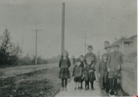
- Scope and Content
- Photograph of two of the Patience family children and their friends near their home at 240 15th Avenue (later renumbered 8078 15th Avenue). (Back right) Una Patience, then in the middle, Wallace Patience (brother). The other children are unidentified neighbourhood friends. Note the loose gravel roa…
- Repository
- City of Burnaby Archives
- Date
- 1923 (date of original), copied 1986
- Collection/Fonds
- Burnaby Historical Society fonds
- Subseries
- Pioneer Tales subseries
- Physical Description
- 1 photograph : b&w ; 12.7 x 17.8 cm print
- Description Level
- Item
- Record No.
- 204-434
- Access Restriction
- No restrictions
- Reproduction Restriction
- No known restrictions
- Accession Number
- BHS1988-03
- Scope and Content
- Photograph of two of the Patience family children and their friends near their home at 240 15th Avenue (later renumbered 8078 15th Avenue). (Back right) Una Patience, then in the middle, Wallace Patience (brother). The other children are unidentified neighbourhood friends. Note the loose gravel road and dense bush.
- Subjects
- Geographic Features - Roads
- Media Type
- Photograph
- Notes
- Title based on contents of photograph
- Geographic Access
- 15th Avenue
- Street Address
- 8078 15th Avenue
- Historic Neighbourhood
- East Burnaby (Historic Neighbourhood)
- Planning Study Area
- Second Street Area
Images