Narrow Results By
Subject
- Advertising Medium - Signs and Signboards 22
- Agriculture - Farms 1
- Arts 1
- Arts - Sculptures 1
- Buildings - Civic 3
- Buildings - Commercial 1
- Buildings - Commercial - Restaurants 2
- Buildings - Commercial - Service Stations 1
- Buildings - Industrial - Refineries 1
- Buildings - Recreational 5
- Buildings - Recreational - Bandstands 1
- Buildings - Recreational - Outdoor Swimming Pools 1
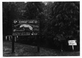
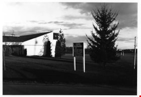
Burnaby Lake Sign (Nature House)
https://search.heritageburnaby.ca/link/archivedescription93629
- Repository
- City of Burnaby Archives
- Date
- October 22, 1977
- Collection/Fonds
- Burnaby Public Library Contemporary Visual Archive Project
- Description Level
- Item
- Physical Description
- 1 photograph : b&w ; 12.5 x 17.5 cm
- Scope and Content
- Photograph of the sign welcoming the public to the Nature House and Burnaby Lake. The sign depicts a map of Burnaby Lake and points of interest, including the rowing complex, pool, ice rink, and Old Mill Site. A smaller sign shows the address of 4519 Piper and a small footbridge is in the backgroun…
- Repository
- City of Burnaby Archives
- Date
- October 22, 1977
- Collection/Fonds
- Burnaby Public Library Contemporary Visual Archive Project
- Physical Description
- 1 photograph : b&w ; 12.5 x 17.5 cm
- Description Level
- Item
- Record No.
- 556-586
- Access Restriction
- No restrictions
- Reproduction Restriction
- Reproduce for fair dealing purposes only
- Accession Number
- 2017-57
- Scope and Content
- Photograph of the sign welcoming the public to the Nature House and Burnaby Lake. The sign depicts a map of Burnaby Lake and points of interest, including the rowing complex, pool, ice rink, and Old Mill Site. A smaller sign shows the address of 4519 Piper and a small footbridge is in the background. The photograph is taken facing southwest.
- Media Type
- Photograph
- Photographer
- Surridge, Jack
- Notes
- Title taken from project information form
- Accompanied by a project information form and 1 photograph (b&w negative ; 9.5 x 12.5 cm)
- BPL no. 35
- Geographic Access
- Burnaby Lake Regional Nature Park
- Street Address
- 4519 Piper Avenue
- Historic Neighbourhood
- Lozells (Historic Neighbourhood)
- Planning Study Area
- Burnaby Lake Area
Images
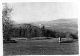
Burnaby Mountain Park
https://search.heritageburnaby.ca/link/archivedescription93639
- Repository
- City of Burnaby Archives
- Date
- November 19, 1977
- Collection/Fonds
- Burnaby Public Library Contemporary Visual Archive Project
- Description Level
- Item
- Physical Description
- 1 photograph : b&w ; 12.5 x 17.5 cm
- Scope and Content
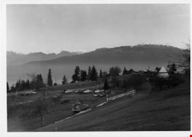
- Photograph of the hillside on the top of Burnaby Mountain Park, with a person in the foreground looking out to the view. The photograph is taken facing northwest and shows the view over the the Burrard Inlet. Capitol Hill, the North Shore Mountains, and downtown Vancouver are visible in the distanc…
- Repository
- City of Burnaby Archives
- Date
- November 19, 1977
- Collection/Fonds
- Burnaby Public Library Contemporary Visual Archive Project
- Physical Description
- 1 photograph : b&w ; 12.5 x 17.5 cm
- Description Level
- Item
- Record No.
- 556-596
- Access Restriction
- No restrictions
- Reproduction Restriction
- Reproduce for fair dealing purposes only
- Accession Number
- 2017-57
- Scope and Content
- Photograph of the hillside on the top of Burnaby Mountain Park, with a person in the foreground looking out to the view. The photograph is taken facing northwest and shows the view over the the Burrard Inlet. Capitol Hill, the North Shore Mountains, and downtown Vancouver are visible in the distance.
- Names
- Burnaby Mountain Park
- Media Type
- Photograph
- Photographer
- van Mannen, Mark
- Notes
- Title taken from project information form
- Accompanied by a project information form and 1 photograph (b&w negative ; 9.5 x 12.5 cm)
- BPL no. 45
- Geographic Access
- Burnaby Mountain Conservation Area
- Planning Study Area
- Burnaby Mountain Area
Images
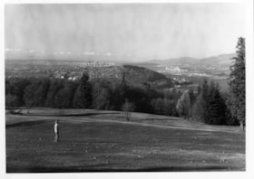
Burnaby Mountain Park
https://search.heritageburnaby.ca/link/archivedescription93640
- Repository
- City of Burnaby Archives
- Date
- November 19, 1977
- Collection/Fonds
- Burnaby Public Library Contemporary Visual Archive Project
- Description Level
- Item
- Physical Description
- 1 photograph : b&w ; 12.5 x 17.5 cm
- Scope and Content
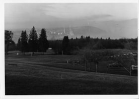
- Photograph of the top of Burnaby Mountain Park and the view of Vancouver from the hillside, with a man standing in the foreground. The photograph is taken facing west of southwest. Capitol Hill, the Burrard Inlet, the North Shore Mountains, Vancouver, and Stanley Park are visible in the distance.
- Repository
- City of Burnaby Archives
- Date
- November 19, 1977
- Collection/Fonds
- Burnaby Public Library Contemporary Visual Archive Project
- Physical Description
- 1 photograph : b&w ; 12.5 x 17.5 cm
- Description Level
- Item
- Record No.
- 556-597
- Access Restriction
- No restrictions
- Reproduction Restriction
- Reproduce for fair dealing purposes only
- Accession Number
- 2017-57
- Scope and Content
- Photograph of the top of Burnaby Mountain Park and the view of Vancouver from the hillside, with a man standing in the foreground. The photograph is taken facing west of southwest. Capitol Hill, the Burrard Inlet, the North Shore Mountains, Vancouver, and Stanley Park are visible in the distance.
- Names
- Burnaby Mountain Park
- Media Type
- Photograph
- Photographer
- McGillivray, Don
- Notes
- Title taken from project information form
- Accompanied by a project information form and 1 photograph (b&w negative ; 9.5 x 12.5 cm)
- BPL no. 46
- Geographic Access
- Burnaby Mountain Conservation Area
- Planning Study Area
- Burnaby Mountain Area
Images
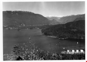
Burnaby Mountain Park
https://search.heritageburnaby.ca/link/archivedescription93645
- Repository
- City of Burnaby Archives
- Date
- November 19, 1977
- Collection/Fonds
- Burnaby Public Library Contemporary Visual Archive Project
- Description Level
- Item
- Physical Description
- 1 photograph : b&w ; 12.5 x 17.5 cm
- Scope and Content
- Photograph of the view from Burnaby Mountain of the Burrard Inlet, the oil refinery, and the mountains. The photograph is taken from Burnaby Mountain Park, facing north.
- Repository
- City of Burnaby Archives
- Date
- November 19, 1977
- Collection/Fonds
- Burnaby Public Library Contemporary Visual Archive Project
- Physical Description
- 1 photograph : b&w ; 12.5 x 17.5 cm
- Description Level
- Item
- Record No.
- 556-602
- Access Restriction
- No restrictions
- Reproduction Restriction
- Reproduce for fair dealing purposes only
- Accession Number
- 2017-57
- Scope and Content
- Photograph of the view from Burnaby Mountain of the Burrard Inlet, the oil refinery, and the mountains. The photograph is taken from Burnaby Mountain Park, facing north.
- Subjects
- Geographic Features - Inlets
- Geographic Features - Parks
- Geographic Features - Mountains
- Buildings - Industrial - Refineries
- Names
- Burnaby Mountain Park
- Media Type
- Photograph
- Photographer
- van Mannen, Mark
- Notes
- Title taken from project information form
- Accompanied by a project information form and 1 photograph (b&w negative ; 9.5 x 12.5 cm)
- BPL no. 52
- Geographic Access
- Burnaby Mountain Conservation Area
- Burrard Inlet
- Planning Study Area
- Burnaby Mountain Area
Images
Burnaby Mountain Park
https://search.heritageburnaby.ca/link/archivedescription37403
- Repository
- City of Burnaby Archives
- Date
- 1970
- Collection/Fonds
- Burnaby Historical Society fonds
- Description Level
- Item
- Physical Description
- 1 photograph : col. postcard ; 9 x 14 cm
- Scope and Content
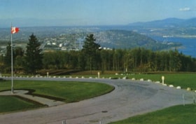
- Photograph of Burnaby Mountain Park looking west towards Vancouver. The caption on the back of the postcard reads: "This view was taken from Burnaby Mountain Park, which is adjacent to Simon Fraser University. Some of the most spectacular views can be seen from this high elevation."
- Repository
- City of Burnaby Archives
- Date
- 1970
- Collection/Fonds
- Burnaby Historical Society fonds
- Subseries
- Robert Prittie subseries
- Physical Description
- 1 photograph : col. postcard ; 9 x 14 cm
- Description Level
- Item
- Record No.
- 369-002
- Access Restriction
- No restrictions
- Reproduction Restriction
- Reproduce for fair dealing purposes only
- Accession Number
- BHS1999-01
- Scope and Content
- Photograph of Burnaby Mountain Park looking west towards Vancouver. The caption on the back of the postcard reads: "This view was taken from Burnaby Mountain Park, which is adjacent to Simon Fraser University. Some of the most spectacular views can be seen from this high elevation."
- Media Type
- Photograph
- Photographer
- Weinhaupl, George
- Notes
- Title based on contents of photograph
- Geographic Access
- Burnaby Mountain Conservation Area
- Centennial Way
- Street Address
- 100 Centennial Way
- Planning Study Area
- Burnaby Mountain Area
Images
Burnaby Mountain Parking Lot & Restaurant
https://search.heritageburnaby.ca/link/archivedescription93706
- Repository
- City of Burnaby Archives
- Date
- February 15, 1978
- Collection/Fonds
- Burnaby Public Library Contemporary Visual Archive Project
- Description Level
- Item
- Physical Description
- 1 photograph : b&w ; 12.5 x 17.5 cm
- Scope and Content
- Photograph of the view of the mountains and park from a hill on Burnaby Mountain Park. The photograph is taken facing north. The photograph shows the parking lot and the Burnaby Mountain Centennial Pavilion.
- Repository
- City of Burnaby Archives
- Date
- February 15, 1978
- Collection/Fonds
- Burnaby Public Library Contemporary Visual Archive Project
- Physical Description
- 1 photograph : b&w ; 12.5 x 17.5 cm
- Description Level
- Item
- Record No.
- 556-663
- Access Restriction
- No restrictions
- Reproduction Restriction
- Reproduce for fair dealing purposes only
- Accession Number
- 2017-57
- Scope and Content
- Photograph of the view of the mountains and park from a hill on Burnaby Mountain Park. The photograph is taken facing north. The photograph shows the parking lot and the Burnaby Mountain Centennial Pavilion.
- Subjects
- Buildings - Commercial - Restaurants
- Buildings - Civic
- Buildings - Recreational
- Geographic Features - Automobile Parking Lots
- Geographic Features - Parks
- Names
- Burnaby Mountain Park
- Media Type
- Photograph
- Photographer
- Surridge, Jack
- Notes
- Title taken from project information form
- Accompanied by a project information form and 1 photograph (b&w negative ; 9.5 x 12.5 cm)
- BPL no. 111
- Geographic Access
- Burnaby Lake Regional Nature Park
- Burnaby Mountain Conservation Area
- Street Address
- 100 Centennial Way
- Planning Study Area
- Burnaby Mountain Area
Images
Burnaby Mountain Park Looking West
https://search.heritageburnaby.ca/link/archivedescription93707
- Repository
- City of Burnaby Archives
- Date
- February 15, 1978
- Collection/Fonds
- Burnaby Public Library Contemporary Visual Archive Project
- Description Level
- Item
- Physical Description
- 1 photograph : b&w ; 12.5 x 17.5 cm
- Scope and Content
- Photograph of the view from Burnaby Mountain Park. The photograph is taken facing west and shows the park, part of the parking lot at the Burnaby Centennial Pavilion, and Capitol Hill and the mountains in the distance.
- Repository
- City of Burnaby Archives
- Date
- February 15, 1978
- Collection/Fonds
- Burnaby Public Library Contemporary Visual Archive Project
- Physical Description
- 1 photograph : b&w ; 12.5 x 17.5 cm
- Description Level
- Item
- Record No.
- 556-664
- Access Restriction
- No restrictions
- Reproduction Restriction
- Reproduce for fair dealing purposes only
- Accession Number
- 2017-57
- Scope and Content
- Photograph of the view from Burnaby Mountain Park. The photograph is taken facing west and shows the park, part of the parking lot at the Burnaby Centennial Pavilion, and Capitol Hill and the mountains in the distance.
- Subjects
- Geographic Features - Parks
- Geographic Features - Mountains
- Geographic Features - Automobile Parking Lots
- Names
- Burnaby Mountain Park
- Media Type
- Photograph
- Photographer
- Surridge, Jack
- Notes
- Title taken from project information form
- Accompanied by a project information form and 1 photograph (b&w negative ; 9.5 x 12.5 cm)
- BPL no. 112
- Geographic Access
- Burnaby Mountain Conservation Area
- Street Address
- 100 Centennial Way
- Planning Study Area
- Burnaby Mountain Area
Images
Burnaby's COVID-19 drive thru testing site
https://search.heritageburnaby.ca/link/museumdescription15374
- Repository
- Burnaby Village Museum
- Date
- 5 Apr. 2020
- Collection/Fonds
- Burnaby Village Museum COVID-19 collection
- Description Level
- Item
- Physical Description
- 1 photograph (jpg)
- Scope and Content
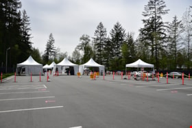
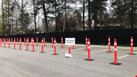
- Photograph of the COVID-19 drive thru testing site in Central Park parking lot in Burnaby. Orange traffic posts and wayfinding signs are set up in the parking lot.
- Repository
- Burnaby Village Museum
- Collection/Fonds
- Burnaby Village Museum COVID-19 collection
- Description Level
- Item
- Physical Description
- 1 photograph (jpg)
- Scope and Content
- Photograph of the COVID-19 drive thru testing site in Central Park parking lot in Burnaby. Orange traffic posts and wayfinding signs are set up in the parking lot.
- Subjects
- Advertising Medium - Signs and Signboards
- Geographic Features - Parks
- Public Services - Health Services
- Pandemics - COVID-19
- Geographic Access
- Central Park
- Imperial Street
- Accession Code
- BV021.2.39
- Access Restriction
- No restrictions
- Reproduction Restriction
- May be restricted by third party rights
- Date
- 5 Apr. 2020
- Media Type
- Photograph
- Historic Neighbourhood
- Central Park (Historic Neighbourhood)
- Planning Study Area
- Maywood Area
- Notes
- Title based on contents of photograph
Images
Burnaby's COVID-19 drive thru testing site
https://search.heritageburnaby.ca/link/museumdescription15375
- Repository
- Burnaby Village Museum
- Date
- 5 Apr. 2020
- Collection/Fonds
- Burnaby Village Museum COVID-19 collection
- Description Level
- Item
- Physical Description
- 1 photograph (jpg)
- Scope and Content
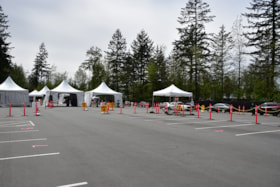
- Photograph of the COVID-19 drive thru testing site in Central Park parking lot in Burnaby. Orange traffic posts, wayfinding signs and white tents are set up in the parking lot.
- Repository
- Burnaby Village Museum
- Collection/Fonds
- Burnaby Village Museum COVID-19 collection
- Description Level
- Item
- Physical Description
- 1 photograph (jpg)
- Scope and Content
- Photograph of the COVID-19 drive thru testing site in Central Park parking lot in Burnaby. Orange traffic posts, wayfinding signs and white tents are set up in the parking lot.
- Subjects
- Advertising Medium - Signs and Signboards
- Geographic Features - Parks
- Public Services - Health Services
- Pandemics - COVID-19
- Geographic Access
- Central Park
- Imperial Street
- Accession Code
- BV021.2.40
- Access Restriction
- No restrictions
- Reproduction Restriction
- May be restricted by third party rights
- Date
- 5 Apr. 2020
- Media Type
- Photograph
- Historic Neighbourhood
- Central Park (Historic Neighbourhood)
- Planning Study Area
- Maywood Area
- Notes
- Title based on contents of photograph
Images
Burnaby's COVID-19 drive thru testing site
https://search.heritageburnaby.ca/link/museumdescription15376
- Repository
- Burnaby Village Museum
- Date
- 5 Apr. 2020
- Collection/Fonds
- Burnaby Village Museum COVID-19 collection
- Description Level
- Item
- Physical Description
- 1 photograph (jpg)
- Scope and Content
- Photograph of the COVID-19 drive thru testing site in Central Park parking lot in Burnaby. Orange traffic posts, wayfinding signs and white tents are set up in the parking lot.
- Repository
- Burnaby Village Museum
- Collection/Fonds
- Burnaby Village Museum COVID-19 collection
- Description Level
- Item
- Physical Description
- 1 photograph (jpg)
- Scope and Content
- Photograph of the COVID-19 drive thru testing site in Central Park parking lot in Burnaby. Orange traffic posts, wayfinding signs and white tents are set up in the parking lot.
- Subjects
- Advertising Medium - Signs and Signboards
- Geographic Features - Parks
- Public Services - Health Services
- Pandemics - COVID-19
- Geographic Access
- Central Park
- Imperial Street
- Accession Code
- BV021.2.41
- Access Restriction
- No restrictions
- Reproduction Restriction
- May be restricted by third party rights
- Date
- 5 Apr. 2020
- Media Type
- Photograph
- Historic Neighbourhood
- Central Park (Historic Neighbourhood)
- Planning Study Area
- Maywood Area
- Notes
- Title based on contents of photograph
Images
Burnaby's COVID-19 drive thru testing site
https://search.heritageburnaby.ca/link/museumdescription15377
- Repository
- Burnaby Village Museum
- Date
- 5 Apr. 2020
- Collection/Fonds
- Burnaby Village Museum COVID-19 collection
- Description Level
- Item
- Physical Description
- 1 photograph (jpg)
- Scope and Content
- Photograph of the COVID-19 drive thru testing site in Central Park parking lot in Burnaby. Orange traffic posts, wayfinding signs and white tents are set up in the parking lot.
- Repository
- Burnaby Village Museum
- Collection/Fonds
- Burnaby Village Museum COVID-19 collection
- Description Level
- Item
- Physical Description
- 1 photograph (jpg)
- Scope and Content
- Photograph of the COVID-19 drive thru testing site in Central Park parking lot in Burnaby. Orange traffic posts, wayfinding signs and white tents are set up in the parking lot.
- Subjects
- Advertising Medium - Signs and Signboards
- Geographic Features - Parks
- Public Services - Health Services
- Pandemics - COVID-19
- Geographic Access
- Central Park
- Imperial Street
- Accession Code
- BV021.2.42
- Access Restriction
- No restrictions
- Reproduction Restriction
- May be restricted by third party rights
- Date
- 5 Apr. 2020
- Media Type
- Photograph
- Historic Neighbourhood
- Central Park (Historic Neighbourhood)
- Planning Study Area
- Maywood Area
- Notes
- Title based on contents of photograph
Images
Burnaby's COVID-19 drive thru testing site
https://search.heritageburnaby.ca/link/museumdescription15378
- Repository
- Burnaby Village Museum
- Date
- 5 Apr. 2020
- Collection/Fonds
- Burnaby Village Museum COVID-19 collection
- Description Level
- Item
- Physical Description
- 1 photograph (jpg)
- Scope and Content
- Photograph of the COVID-19 drive thru testing site in Central Park parking lot in Burnaby. Orange traffic posts, wayfinding signs and white tents are set up in the parking lot.
- Repository
- Burnaby Village Museum
- Collection/Fonds
- Burnaby Village Museum COVID-19 collection
- Description Level
- Item
- Physical Description
- 1 photograph (jpg)
- Scope and Content
- Photograph of the COVID-19 drive thru testing site in Central Park parking lot in Burnaby. Orange traffic posts, wayfinding signs and white tents are set up in the parking lot.
- Subjects
- Advertising Medium - Signs and Signboards
- Geographic Features - Parks
- Public Services - Health Services
- Pandemics - COVID-19
- Geographic Access
- Central Park
- Imperial Street
- Accession Code
- BV021.2.43
- Access Restriction
- No restrictions
- Reproduction Restriction
- May be restricted by third party rights
- Date
- 5 Apr. 2020
- Media Type
- Photograph
- Historic Neighbourhood
- Central Park (Historic Neighbourhood)
- Planning Study Area
- Maywood Area
- Notes
- Title based on contents of photograph
Images
Burnaby's COVID-19 drive thru testing site
https://search.heritageburnaby.ca/link/museumdescription15379
- Repository
- Burnaby Village Museum
- Date
- 5 Apr. 2020
- Collection/Fonds
- Burnaby Village Museum COVID-19 collection
- Description Level
- Item
- Physical Description
- 1 photograph (jpg)
- Scope and Content
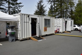
- Photograph of the COVID-19 drive thru testing site in Central Park parking lot in Burnaby. Orange traffic posts, wayfinding signs, white tents and white buildings converted from shipping containers are set up in the parking lot.
- Repository
- Burnaby Village Museum
- Collection/Fonds
- Burnaby Village Museum COVID-19 collection
- Description Level
- Item
- Physical Description
- 1 photograph (jpg)
- Scope and Content
- Photograph of the COVID-19 drive thru testing site in Central Park parking lot in Burnaby. Orange traffic posts, wayfinding signs, white tents and white buildings converted from shipping containers are set up in the parking lot.
- Subjects
- Advertising Medium - Signs and Signboards
- Geographic Features - Parks
- Public Services - Health Services
- Pandemics - COVID-19
- Geographic Access
- Central Park
- Imperial Street
- Accession Code
- BV021.2.44
- Access Restriction
- No restrictions
- Reproduction Restriction
- May be restricted by third party rights
- Date
- 5 Apr. 2020
- Media Type
- Photograph
- Historic Neighbourhood
- Central Park (Historic Neighbourhood)
- Planning Study Area
- Maywood Area
- Notes
- Title based on contents of photograph
Images
Burnaby's COVID-19 drive thru testing site
https://search.heritageburnaby.ca/link/museumdescription15380
- Repository
- Burnaby Village Museum
- Date
- 5 Apr. 2020
- Collection/Fonds
- Burnaby Village Museum COVID-19 collection
- Description Level
- Item
- Physical Description
- 1 photograph (jpg)
- Scope and Content
- Photograph of the COVID-19 drive thru testing site in Central Park parking lot in Burnaby. Orange traffic posts, wayfinding signs and white tents are set up in the parking lot.
- Repository
- Burnaby Village Museum
- Collection/Fonds
- Burnaby Village Museum COVID-19 collection
- Description Level
- Item
- Physical Description
- 1 photograph (jpg)
- Scope and Content
- Photograph of the COVID-19 drive thru testing site in Central Park parking lot in Burnaby. Orange traffic posts, wayfinding signs and white tents are set up in the parking lot.
- Subjects
- Advertising Medium - Signs and Signboards
- Geographic Features - Parks
- Public Services - Health Services
- Pandemics - COVID-19
- Geographic Access
- Central Park
- Imperial Street
- Accession Code
- BV021.2.45
- Access Restriction
- No restrictions
- Reproduction Restriction
- May be restricted by third party rights
- Date
- 5 Apr. 2020
- Media Type
- Photograph
- Historic Neighbourhood
- Central Park (Historic Neighbourhood)
- Planning Study Area
- Maywood Area
- Notes
- Title based on contents of photograph
Images
Burnaby's COVID-19 drive thru testing site
https://search.heritageburnaby.ca/link/museumdescription15381
- Repository
- Burnaby Village Museum
- Date
- 5 Apr. 2020
- Collection/Fonds
- Burnaby Village Museum COVID-19 collection
- Description Level
- Item
- Physical Description
- 1 photograph (jpg)
- Scope and Content
- Photograph of the COVID-19 drive thru testing site in Central Park parking lot in Burnaby. Orange traffic posts, wayfinding signs and white tents are set up in the parking lot.
- Repository
- Burnaby Village Museum
- Collection/Fonds
- Burnaby Village Museum COVID-19 collection
- Description Level
- Item
- Physical Description
- 1 photograph (jpg)
- Scope and Content
- Photograph of the COVID-19 drive thru testing site in Central Park parking lot in Burnaby. Orange traffic posts, wayfinding signs and white tents are set up in the parking lot.
- Subjects
- Advertising Medium - Signs and Signboards
- Geographic Features - Parks
- Public Services - Health Services
- Pandemics - COVID-19
- Geographic Access
- Central Park
- Imperial Street
- Accession Code
- BV021.2.46
- Access Restriction
- No restrictions
- Reproduction Restriction
- May be restricted by third party rights
- Date
- 5 Apr. 2020
- Media Type
- Photograph
- Historic Neighbourhood
- Central Park (Historic Neighbourhood)
- Planning Study Area
- Maywood Area
- Notes
- Title based on contents of photograph
Images
Burnaby's COVID-19 drive thru testing site
https://search.heritageburnaby.ca/link/museumdescription15382
- Repository
- Burnaby Village Museum
- Date
- 5 Apr. 2020
- Collection/Fonds
- Burnaby Village Museum COVID-19 collection
- Description Level
- Item
- Physical Description
- 1 photograph (jpg)
- Scope and Content
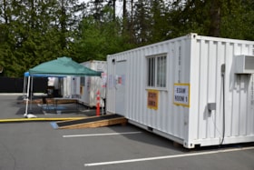
- Photograph of the COVID-19 drive thru testing site in Central Park parking lot in Burnaby. White shipping container buildings have been set up in the parking lot.
- Repository
- Burnaby Village Museum
- Collection/Fonds
- Burnaby Village Museum COVID-19 collection
- Description Level
- Item
- Physical Description
- 1 photograph (jpg)
- Scope and Content
- Photograph of the COVID-19 drive thru testing site in Central Park parking lot in Burnaby. White shipping container buildings have been set up in the parking lot.
- Subjects
- Advertising Medium - Signs and Signboards
- Geographic Features - Parks
- Public Services - Health Services
- Pandemics - COVID-19
- Geographic Access
- Central Park
- Imperial Street
- Accession Code
- BV021.2.47
- Access Restriction
- No restrictions
- Reproduction Restriction
- May be restricted by third party rights
- Date
- 5 Apr. 2020
- Media Type
- Photograph
- Historic Neighbourhood
- Central Park (Historic Neighbourhood)
- Planning Study Area
- Maywood Area
- Notes
- Title based on contents of photograph
Images
Burnaby's COVID-19 drive thru testing site
https://search.heritageburnaby.ca/link/museumdescription15383
- Repository
- Burnaby Village Museum
- Date
- 5 Apr. 2020
- Collection/Fonds
- Burnaby Village Museum COVID-19 collection
- Description Level
- Item
- Physical Description
- 1 photograph (jpg)
- Scope and Content
- Photograph of the COVID-19 drive thru testing site in Central Park parking lot in Burnaby. White shipping container buildings have been set up in the parking lot.
- Repository
- Burnaby Village Museum
- Collection/Fonds
- Burnaby Village Museum COVID-19 collection
- Description Level
- Item
- Physical Description
- 1 photograph (jpg)
- Scope and Content
- Photograph of the COVID-19 drive thru testing site in Central Park parking lot in Burnaby. White shipping container buildings have been set up in the parking lot.
- Subjects
- Advertising Medium - Signs and Signboards
- Geographic Features - Parks
- Public Services - Health Services
- Pandemics - COVID-19
- Geographic Access
- Central Park
- Imperial Street
- Accession Code
- BV021.2.48
- Access Restriction
- No restrictions
- Reproduction Restriction
- May be restricted by third party rights
- Date
- 5 Apr. 2020
- Media Type
- Photograph
- Historic Neighbourhood
- Central Park (Historic Neighbourhood)
- Planning Study Area
- Maywood Area
- Notes
- Title based on contents of photograph
Images
Burnaby's COVID-19 drive thru testing site
https://search.heritageburnaby.ca/link/museumdescription15391
- Repository
- Burnaby Village Museum
- Date
- 27 Apr. 2020
- Collection/Fonds
- Burnaby Village Museum COVID-19 collection
- Description Level
- Item
- Physical Description
- 1 video recording (mp4) (17 sec.) : digital, 24 fps, col., si.
- Scope and Content
- Film clip (no sound) of the COVID-19 drive thru testing site in Central Park parking lot in Burnaby. Orange traffic posts, wayfinding signs and white tents are set up in the parking lot and staff are wearing protective face masks.
- Repository
- Burnaby Village Museum
- Collection/Fonds
- Burnaby Village Museum COVID-19 collection
- Description Level
- Item
- Physical Description
- 1 video recording (mp4) (17 sec.) : digital, 24 fps, col., si.
- Scope and Content
- Film clip (no sound) of the COVID-19 drive thru testing site in Central Park parking lot in Burnaby. Orange traffic posts, wayfinding signs and white tents are set up in the parking lot and staff are wearing protective face masks.
- Subjects
- Advertising Medium - Signs and Signboards
- Geographic Features - Parks
- Public Services - Health Services
- Pandemics - COVID-19
- Geographic Access
- Central Park
- Imperial Street
- Accession Code
- BV021.2.8
- Access Restriction
- No restrictions
- Reproduction Restriction
- May be restricted by third party rights
- Date
- 27 Apr. 2020
- Media Type
- Moving Images
- Historic Neighbourhood
- Central Park (Historic Neighbourhood)
- Planning Study Area
- Maywood Area
- Notes
- Title based on contents of photograph
Images
Video
Burnaby's COVID-19 drive thru testing site, 27 Apr. 2020
Burnaby's COVID-19 drive thru testing site, 27 Apr. 2020
https://search.heritageburnaby.ca/media/hpo/_Data/_BVM_Moving_Images/2021_0002_0008_001.mp4Cape Burnaby Rocket Club
https://search.heritageburnaby.ca/link/archivedescription93675
- Repository
- City of Burnaby Archives
- Date
- February 5, 1978
- Collection/Fonds
- Burnaby Public Library Contemporary Visual Archive Project
- Description Level
- Item
- Physical Description
- 1 photograph : b&w ; 12.5 x 17.5 cm
- Scope and Content
- Photograph of a sign for "Cape Burnaby," posted on park grounds near Sperling Avenue, with a building in the background that appears to be the Burnaby Lake Clubhouse. The sign reads: "Cape Burnaby Launch Site of Burnaby Model Rocket Club in Cooperation with Burnaby Parks & Recreation Comm." The ph…
- Repository
- City of Burnaby Archives
- Date
- February 5, 1978
- Collection/Fonds
- Burnaby Public Library Contemporary Visual Archive Project
- Physical Description
- 1 photograph : b&w ; 12.5 x 17.5 cm
- Description Level
- Item
- Record No.
- 556-632
- Access Restriction
- No restrictions
- Reproduction Restriction
- Reproduce for fair dealing purposes only
- Accession Number
- 2017-57
- Scope and Content
- Photograph of a sign for "Cape Burnaby," posted on park grounds near Sperling Avenue, with a building in the background that appears to be the Burnaby Lake Clubhouse. The sign reads: "Cape Burnaby Launch Site of Burnaby Model Rocket Club in Cooperation with Burnaby Parks & Recreation Comm." The photograph is taken from the sidewalk, facing east.
- Media Type
- Photograph
- Photographer
- Surridge, Jack
- Notes
- Title taken from project information form
- Accompanied by a project information form and 1 photograph (b&w negative ; 9.5 x 12.5 cm)
- BPL no. 81
- Geographic Access
- Burnaby Lake Regional Nature Park
- Historic Neighbourhood
- Burnaby Lake (Historic Neighbourhood)
- Planning Study Area
- Burnaby Lake Area
Images
Centennial Pavilion and Burnaby Mountain Park
https://search.heritageburnaby.ca/link/archivedescription37410
- Repository
- City of Burnaby Archives
- Date
- 1970
- Collection/Fonds
- Burnaby Historical Society fonds
- Description Level
- Item
- Physical Description
- 1 photograph : col. postcard ; 9 x 14 cm
- Scope and Content
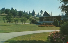
- Photographic postcard of the rear portion of the Centennial Pavilion along with a view of some of the landscaping at Burnaby Mountain Park. The caption on the back of the photograph reads: "This park is situated on the western portion of Burnaby Mountain. Numerous view points throughout beautiful…
- Repository
- City of Burnaby Archives
- Date
- 1970
- Collection/Fonds
- Burnaby Historical Society fonds
- Subseries
- Robert Prittie subseries
- Physical Description
- 1 photograph : col. postcard ; 9 x 14 cm
- Description Level
- Item
- Record No.
- 369-009
- Access Restriction
- No restrictions
- Reproduction Restriction
- Reproduce for fair dealing purposes only
- Accession Number
- BHS1999-01
- Scope and Content
- Photographic postcard of the rear portion of the Centennial Pavilion along with a view of some of the landscaping at Burnaby Mountain Park. The caption on the back of the photograph reads: "This park is situated on the western portion of Burnaby Mountain. Numerous view points throughout beautifully landscaped grounds provide magnificent views of Burrard Inlet, Coast Range Mountains, City of Vancouver and surrounding Municipalities."
- Media Type
- Photograph
- Photographer
- George Allen Aerial Photos Limited
- Notes
- Title based on caption
- Geographic Access
- Burnaby Mountain Conservation Area
- Centennial Way
- Street Address
- 100 Centennial Way
- Planning Study Area
- Burnaby Mountain Area
