Narrow Results By
Subject
- Buildings - Civic 3
- Buildings - Commercial 1
- Buildings - Commercial - Restaurants 1
- Buildings - Commercial - Service Stations 1
- Buildings - Industrial - Refineries 1
- Buildings - Recreational 5
- Buildings - Recreational - Outdoor Swimming Pools 1
- Buildings - Recreational - Swimming Pools 1
- Buildings - Residential - Apartments 3
- Celebrations - Centennial 1
- Ceremonies 9
- Documentary Artifacts - Postcards 2

Stream in Robert Burnaby Park
https://search.heritageburnaby.ca/link/archivedescription93668
- Repository
- City of Burnaby Archives
- Date
- January 15, 1978
- Collection/Fonds
- Burnaby Public Library Contemporary Visual Archive Project
- Description Level
- Item
- Physical Description
- 1 photograph : b&w ; 12.5 x 17.5 cm
- Scope and Content
- Photograph of a mostly dry stream in Robert Burnaby Park. The stream is surrounded by a forested area and the photograph shows a footbridge in the background. The photograph is taken in front of the stream, facing south.
- Repository
- City of Burnaby Archives
- Date
- January 15, 1978
- Collection/Fonds
- Burnaby Public Library Contemporary Visual Archive Project
- Physical Description
- 1 photograph : b&w ; 12.5 x 17.5 cm
- Description Level
- Item
- Record No.
- 556-625
- Access Restriction
- No restrictions
- Reproduction Restriction
- Reproduce for fair dealing purposes only
- Accession Number
- 2017-57
- Scope and Content
- Photograph of a mostly dry stream in Robert Burnaby Park. The stream is surrounded by a forested area and the photograph shows a footbridge in the background. The photograph is taken in front of the stream, facing south.
- Media Type
- Photograph
- Photographer
- Surridge, Jack
- Notes
- Title taken from project information form
- Accompanied by a project information form and 1 photograph (b&w negative ; 9.5 x 12.5 cm)
- BPL no. 74
- Geographic Access
- Robert Burnaby Park
- Historic Neighbourhood
- Burnaby Lake (Historic Neighbourhood)
- Planning Study Area
- Lakeview-Mayfield Area
Images


Cape Burnaby Rocket Club
https://search.heritageburnaby.ca/link/archivedescription93675
- Repository
- City of Burnaby Archives
- Date
- February 5, 1978
- Collection/Fonds
- Burnaby Public Library Contemporary Visual Archive Project
- Description Level
- Item
- Physical Description
- 1 photograph : b&w ; 12.5 x 17.5 cm
- Scope and Content
- Photograph of a sign for "Cape Burnaby," posted on park grounds near Sperling Avenue, with a building in the background that appears to be the Burnaby Lake Clubhouse. The sign reads: "Cape Burnaby Launch Site of Burnaby Model Rocket Club in Cooperation with Burnaby Parks & Recreation Comm." The ph…
- Repository
- City of Burnaby Archives
- Date
- February 5, 1978
- Collection/Fonds
- Burnaby Public Library Contemporary Visual Archive Project
- Physical Description
- 1 photograph : b&w ; 12.5 x 17.5 cm
- Description Level
- Item
- Record No.
- 556-632
- Access Restriction
- No restrictions
- Reproduction Restriction
- Reproduce for fair dealing purposes only
- Accession Number
- 2017-57
- Scope and Content
- Photograph of a sign for "Cape Burnaby," posted on park grounds near Sperling Avenue, with a building in the background that appears to be the Burnaby Lake Clubhouse. The sign reads: "Cape Burnaby Launch Site of Burnaby Model Rocket Club in Cooperation with Burnaby Parks & Recreation Comm." The photograph is taken from the sidewalk, facing east.
- Media Type
- Photograph
- Photographer
- Surridge, Jack
- Notes
- Title taken from project information form
- Accompanied by a project information form and 1 photograph (b&w negative ; 9.5 x 12.5 cm)
- BPL no. 81
- Geographic Access
- Burnaby Lake Regional Nature Park
- Historic Neighbourhood
- Burnaby Lake (Historic Neighbourhood)
- Planning Study Area
- Burnaby Lake Area
Images

Kensington Pitch & Putt
https://search.heritageburnaby.ca/link/archivedescription93681
- Repository
- City of Burnaby Archives
- Date
- May 27, 1978
- Collection/Fonds
- Burnaby Public Library Contemporary Visual Archive Project
- Description Level
- Item
- Physical Description
- 1 photograph : b&w ; 12.5 x 17.5 cm
- Scope and Content
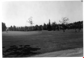
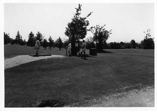
- Photograph of the greens at Kensington Pitch & Putt golf course, located on the 5800 block of Curtis Street. Two golfers are on the green in the foreground; one is lining up a shot. A small group of golfers is visible in the distance. The photograph is taken from across the green, facing northeast.
- Repository
- City of Burnaby Archives
- Date
- May 27, 1978
- Collection/Fonds
- Burnaby Public Library Contemporary Visual Archive Project
- Physical Description
- 1 photograph : b&w ; 12.5 x 17.5 cm
- Description Level
- Item
- Record No.
- 556-638
- Access Restriction
- No restrictions
- Reproduction Restriction
- Reproduce for fair dealing purposes only
- Accession Number
- 2017-57
- Scope and Content
- Photograph of the greens at Kensington Pitch & Putt golf course, located on the 5800 block of Curtis Street. Two golfers are on the green in the foreground; one is lining up a shot. A small group of golfers is visible in the distance. The photograph is taken from across the green, facing northeast.
- Media Type
- Photograph
- Photographer
- Surridge, Jack
- Notes
- Title taken from project information form
- Accompanied by a project information form and 1 photograph (b&w negative ; 9.5 x 12.5 cm)
- BPL no. 87
- Street Address
- 5889 Curtis Street
- 6159 Curtis Street
- Planning Study Area
- Parkcrest-Aubrey Area
Images

Kensington Pitch & Putt
https://search.heritageburnaby.ca/link/archivedescription93682
- Repository
- City of Burnaby Archives
- Date
- May 27, 1978
- Collection/Fonds
- Burnaby Public Library Contemporary Visual Archive Project
- Description Level
- Item
- Physical Description
- 1 photograph : b&w ; 12.5 x 17.5 cm
- Scope and Content
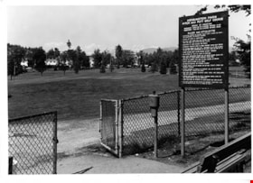
- Photograph of the Kensington Pitch & Putt Golf Course on the 5800 block of Curtis Street. The photograph shows a sign displaying the rules and etiquette for the golf course in the foreground, next to a chainlink fence. The photograph is taken facing northwest, and the mountains are visible in the d…
- Repository
- City of Burnaby Archives
- Date
- May 27, 1978
- Collection/Fonds
- Burnaby Public Library Contemporary Visual Archive Project
- Physical Description
- 1 photograph : b&w ; 12.5 x 17.5 cm
- Description Level
- Item
- Record No.
- 556-639
- Access Restriction
- No restrictions
- Reproduction Restriction
- Reproduce for fair dealing purposes only
- Accession Number
- 2017-57
- Scope and Content
- Photograph of the Kensington Pitch & Putt Golf Course on the 5800 block of Curtis Street. The photograph shows a sign displaying the rules and etiquette for the golf course in the foreground, next to a chainlink fence. The photograph is taken facing northwest, and the mountains are visible in the distance.
- Media Type
- Photograph
- Photographer
- Surridge, Jack
- Notes
- Title taken from project information form
- Accompanied by a project information form and 1 photograph (b&w negative ; 9.5 x 12.5 cm)
- BPL no. 88
- Street Address
- 5889 Curtis Street
- 6159 Curtis Street
- Planning Study Area
- Parkcrest-Aubrey Area
Images

Kensington Pitch & Putt
https://search.heritageburnaby.ca/link/archivedescription93683
- Repository
- City of Burnaby Archives
- Date
- May 27, 1978
- Collection/Fonds
- Burnaby Public Library Contemporary Visual Archive Project
- Description Level
- Item
- Physical Description
- 1 photograph : b&w ; 12.5 x 17.5 cm
- Scope and Content
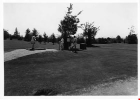
- Photograph of the Kensington Pitch & Putt Golf Course on the 5800 block of Curtis Street. Three golfers are on the green; one is lining up a shot on the teeing green. The photograph is taken facing southeast.
- Repository
- City of Burnaby Archives
- Date
- May 27, 1978
- Collection/Fonds
- Burnaby Public Library Contemporary Visual Archive Project
- Physical Description
- 1 photograph : b&w ; 12.5 x 17.5 cm
- Description Level
- Item
- Record No.
- 556-640
- Access Restriction
- No restrictions
- Reproduction Restriction
- Reproduce for fair dealing purposes only
- Accession Number
- 2017-57
- Scope and Content
- Photograph of the Kensington Pitch & Putt Golf Course on the 5800 block of Curtis Street. Three golfers are on the green; one is lining up a shot on the teeing green. The photograph is taken facing southeast.
- Media Type
- Photograph
- Photographer
- Surridge, Jack
- Notes
- Title taken from project information form
- Accompanied by a project information form and 1 photograph (b&w negative ; 9.5 x 12.5 cm)
- BPL no. 88
- Street Address
- 5889 Curtis Street
- 6159 Curtis Street
- Planning Study Area
- Parkcrest-Aubrey Area
Images

Central Park Tennis Courts
https://search.heritageburnaby.ca/link/archivedescription93684
- Repository
- City of Burnaby Archives
- Date
- May 27, 1978
- Collection/Fonds
- Burnaby Public Library Contemporary Visual Archive Project
- Description Level
- Item
- Physical Description
- 1 photograph : b&w ; 12.5 x 17.5 cm
- Scope and Content
- Photograph of tennis players playing in the tennis courts in Central Park, on Patterson Avenue. The photograph is taken from outside the fence around the courts, facing south.
- Repository
- City of Burnaby Archives
- Date
- May 27, 1978
- Collection/Fonds
- Burnaby Public Library Contemporary Visual Archive Project
- Physical Description
- 1 photograph : b&w ; 12.5 x 17.5 cm
- Description Level
- Item
- Record No.
- 556-641
- Access Restriction
- No restrictions
- Reproduction Restriction
- Reproduce for fair dealing purposes only
- Accession Number
- 2017-57
- Scope and Content
- Photograph of tennis players playing in the tennis courts in Central Park, on Patterson Avenue. The photograph is taken from outside the fence around the courts, facing south.
- Media Type
- Photograph
- Photographer
- Surridge, Jack
- Notes
- Title taken from project information form
- Accompanied by a project information form and 1 photograph (b&w negative ; 9.5 x 12.5 cm)
- BPL no. 89
- Geographic Access
- Central Park
- Patterson Avenue
- Historic Neighbourhood
- Central Park (Historic Neighbourhood)
- Planning Study Area
- Maywood Area
Images


Central Park Tennis Courts
https://search.heritageburnaby.ca/link/archivedescription93685
- Repository
- City of Burnaby Archives
- Date
- May 27, 1978
- Collection/Fonds
- Burnaby Public Library Contemporary Visual Archive Project
- Description Level
- Item
- Physical Description
- 1 photograph : b&w ; 12.5 x 17.5 cm
- Scope and Content
- Photograph of the tennis courts in Central Park, on Patterson Avenue. The photograph is taken from across one of the sets of courts, facing north. Tennis players are visible in the far set of courts, on the other side of a fence.
- Repository
- City of Burnaby Archives
- Date
- May 27, 1978
- Collection/Fonds
- Burnaby Public Library Contemporary Visual Archive Project
- Physical Description
- 1 photograph : b&w ; 12.5 x 17.5 cm
- Description Level
- Item
- Record No.
- 556-642
- Access Restriction
- No restrictions
- Reproduction Restriction
- Reproduce for fair dealing purposes only
- Accession Number
- 2017-57
- Scope and Content
- Photograph of the tennis courts in Central Park, on Patterson Avenue. The photograph is taken from across one of the sets of courts, facing north. Tennis players are visible in the far set of courts, on the other side of a fence.
- Media Type
- Photograph
- Photographer
- Surridge, Jack
- Notes
- Title taken from project information form
- Accompanied by a project information form and 1 photograph (b&w negative ; 9.5 x 12.5 cm)
- BPL no. 90
- Geographic Access
- Central Park
- Patterson Avenue
- Historic Neighbourhood
- Central Park (Historic Neighbourhood)
- Planning Study Area
- Maywood Area
Images

Lacrosse Box at Stride Ave Apartments
https://search.heritageburnaby.ca/link/archivedescription93688
- Repository
- City of Burnaby Archives
- Date
- May 15, 1978
- Collection/Fonds
- Burnaby Public Library Contemporary Visual Archive Project
- Description Level
- Item
- Physical Description
- 1 photograph : b&w ; 12.5 x 17.5 cm
- Scope and Content
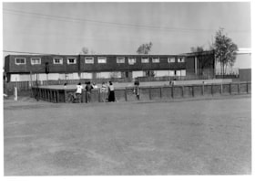
- Photograph of the lacrosse box outside a row of low-rise apartments. Children are leaning on or sitting on the boards of the box. The photograph is taken from a lawn or park, facing east.
- Repository
- City of Burnaby Archives
- Date
- May 15, 1978
- Collection/Fonds
- Burnaby Public Library Contemporary Visual Archive Project
- Physical Description
- 1 photograph : b&w ; 12.5 x 17.5 cm
- Description Level
- Item
- Record No.
- 556-645
- Access Restriction
- No restrictions
- Reproduction Restriction
- Reproduce for fair dealing purposes only
- Accession Number
- 2017-57
- Scope and Content
- Photograph of the lacrosse box outside a row of low-rise apartments. Children are leaning on or sitting on the boards of the box. The photograph is taken from a lawn or park, facing east.
- Media Type
- Photograph
- Photographer
- van Mannen, Mark
- Notes
- Title taken from project information form
- Accompanied by a project information form and 1 photograph (b&w negative ; 9.5 x 12.5 cm)
- BPL no. 93
- Geographic Access
- Stride Avenue
- Historic Neighbourhood
- Edmonds (Historic Neighbourhood)
- Planning Study Area
- Edmonds Area
Images


Highrises at Central Park
https://search.heritageburnaby.ca/link/archivedescription93690
- Repository
- City of Burnaby Archives
- Date
- June 4, 1978
- Collection/Fonds
- Burnaby Public Library Contemporary Visual Archive Project
- Description Level
- Item
- Physical Description
- 1 photograph : b&w ; 12.5 x 17.5 cm
- Scope and Content
- Photograph of high-rise apartment buildings next to Central Park. One of the apartments has a sign that reads "Central Park Place." A sign for Central Park is in the foreground on the edge of a grassy lawn and gravel road, where cars are parked. The photograph is taken facing east.
- Repository
- City of Burnaby Archives
- Date
- June 4, 1978
- Collection/Fonds
- Burnaby Public Library Contemporary Visual Archive Project
- Physical Description
- 1 photograph : b&w ; 12.5 x 17.5 cm
- Description Level
- Item
- Record No.
- 556-647
- Access Restriction
- No restrictions
- Reproduction Restriction
- Reproduce for fair dealing purposes only
- Accession Number
- 2017-57
- Scope and Content
- Photograph of high-rise apartment buildings next to Central Park. One of the apartments has a sign that reads "Central Park Place." A sign for Central Park is in the foreground on the edge of a grassy lawn and gravel road, where cars are parked. The photograph is taken facing east.
- Media Type
- Photograph
- Photographer
- Chapman, Fred
- Notes
- Title taken from project information form
- Accompanied by a project information form and 1 photograph (b&w negative ; 9.5 x 12.5 cm)
- BPL no. 95
- Geographic Access
- Central Park
- Patterson Avenue
- Kingsway
- Historic Neighbourhood
- Central Park (Historic Neighbourhood)
- Planning Study Area
- Cascade-Schou Area
Images


Highrises on Kingsway
https://search.heritageburnaby.ca/link/archivedescription93692
- Repository
- City of Burnaby Archives
- Date
- June 4, 1978
- Collection/Fonds
- Burnaby Public Library Contemporary Visual Archive Project
- Description Level
- Item
- Physical Description
- 1 photograph : b&w ; 12.5 x 17.5 cm
- Scope and Content
- Photograph of high-rises apartment buildings and the neighbourhood along Kingsway by Central Park. The photograph is taken from a high point, facing east down Kingsway. The Central Park Veterinary Hospital, Central Park Place, a railway crossing, a gas station, and the Central Park Gate are visible…
- Repository
- City of Burnaby Archives
- Date
- June 4, 1978
- Collection/Fonds
- Burnaby Public Library Contemporary Visual Archive Project
- Physical Description
- 1 photograph : b&w ; 12.5 x 17.5 cm
- Description Level
- Item
- Record No.
- 556-649
- Access Restriction
- No restrictions
- Reproduction Restriction
- Reproduce for fair dealing purposes only
- Accession Number
- 2017-57
- Scope and Content
- Photograph of high-rises apartment buildings and the neighbourhood along Kingsway by Central Park. The photograph is taken from a high point, facing east down Kingsway. The Central Park Veterinary Hospital, Central Park Place, a railway crossing, a gas station, and the Central Park Gate are visible in the photograph.
- Subjects
- Buildings - Commercial
- Buildings - Residential - Apartments
- Buildings - Commercial - Service Stations
- Geographic Features - Parks
- Monuments
- Media Type
- Photograph
- Photographer
- Chapman, Fred
- Notes
- Title taken from project information form
- Accompanied by a project information form and 1 photograph (b&w negative ; 9.5 x 12.5 cm)
- BPL no. 97
- Geographic Access
- Kingsway
- Central Park
- Historic Neighbourhood
- Central Park (Historic Neighbourhood)
- Planning Study Area
- Maywood Area
Images


Burnaby Mountain Parking Lot & Restaurant
https://search.heritageburnaby.ca/link/archivedescription93706
- Repository
- City of Burnaby Archives
- Date
- February 15, 1978
- Collection/Fonds
- Burnaby Public Library Contemporary Visual Archive Project
- Description Level
- Item
- Physical Description
- 1 photograph : b&w ; 12.5 x 17.5 cm
- Scope and Content
- Photograph of the view of the mountains and park from a hill on Burnaby Mountain Park. The photograph is taken facing north. The photograph shows the parking lot and the Burnaby Mountain Centennial Pavilion.
- Repository
- City of Burnaby Archives
- Date
- February 15, 1978
- Collection/Fonds
- Burnaby Public Library Contemporary Visual Archive Project
- Physical Description
- 1 photograph : b&w ; 12.5 x 17.5 cm
- Description Level
- Item
- Record No.
- 556-663
- Access Restriction
- No restrictions
- Reproduction Restriction
- Reproduce for fair dealing purposes only
- Accession Number
- 2017-57
- Scope and Content
- Photograph of the view of the mountains and park from a hill on Burnaby Mountain Park. The photograph is taken facing north. The photograph shows the parking lot and the Burnaby Mountain Centennial Pavilion.
- Subjects
- Buildings - Commercial - Restaurants
- Buildings - Civic
- Buildings - Recreational
- Geographic Features - Automobile Parking Lots
- Geographic Features - Parks
- Names
- Burnaby Mountain Park
- Media Type
- Photograph
- Photographer
- Surridge, Jack
- Notes
- Title taken from project information form
- Accompanied by a project information form and 1 photograph (b&w negative ; 9.5 x 12.5 cm)
- BPL no. 111
- Geographic Access
- Burnaby Lake Regional Nature Park
- Burnaby Mountain Conservation Area
- Street Address
- 100 Centennial Way
- Planning Study Area
- Burnaby Mountain Area
Images


Burnaby Mountain Park Looking West
https://search.heritageburnaby.ca/link/archivedescription93707
- Repository
- City of Burnaby Archives
- Date
- February 15, 1978
- Collection/Fonds
- Burnaby Public Library Contemporary Visual Archive Project
- Description Level
- Item
- Physical Description
- 1 photograph : b&w ; 12.5 x 17.5 cm
- Scope and Content
- Photograph of the view from Burnaby Mountain Park. The photograph is taken facing west and shows the park, part of the parking lot at the Burnaby Centennial Pavilion, and Capitol Hill and the mountains in the distance.
- Repository
- City of Burnaby Archives
- Date
- February 15, 1978
- Collection/Fonds
- Burnaby Public Library Contemporary Visual Archive Project
- Physical Description
- 1 photograph : b&w ; 12.5 x 17.5 cm
- Description Level
- Item
- Record No.
- 556-664
- Access Restriction
- No restrictions
- Reproduction Restriction
- Reproduce for fair dealing purposes only
- Accession Number
- 2017-57
- Scope and Content
- Photograph of the view from Burnaby Mountain Park. The photograph is taken facing west and shows the park, part of the parking lot at the Burnaby Centennial Pavilion, and Capitol Hill and the mountains in the distance.
- Subjects
- Geographic Features - Parks
- Geographic Features - Mountains
- Geographic Features - Automobile Parking Lots
- Names
- Burnaby Mountain Park
- Media Type
- Photograph
- Photographer
- Surridge, Jack
- Notes
- Title taken from project information form
- Accompanied by a project information form and 1 photograph (b&w negative ; 9.5 x 12.5 cm)
- BPL no. 112
- Geographic Access
- Burnaby Mountain Conservation Area
- Street Address
- 100 Centennial Way
- Planning Study Area
- Burnaby Mountain Area
Images


Nature House
https://search.heritageburnaby.ca/link/archivedescription93628
- Repository
- City of Burnaby Archives
- Date
- October 22, 1977
- Collection/Fonds
- Burnaby Public Library Contemporary Visual Archive Project
- Description Level
- Item
- Physical Description
- 1 photograph : b&w ; 12.5 x 17.5 cm
- Scope and Content
- Photograph of the Burnaby Lake Nature House at 4519 Piper Avenue in Burnaby Lake Regional Park. The photograph is taken facing southwest. The Nature House was built in 1940. The sign for the Nature House is just visible on the left side of the photograph, and canoes are stacked outside beside the b…
- Repository
- City of Burnaby Archives
- Date
- October 22, 1977
- Collection/Fonds
- Burnaby Public Library Contemporary Visual Archive Project
- Physical Description
- 1 photograph : b&w ; 12.5 x 17.5 cm
- Description Level
- Item
- Record No.
- 556-585
- Access Restriction
- No restrictions
- Reproduction Restriction
- Reproduce for fair dealing purposes only
- Accession Number
- 2017-57
- Scope and Content
- Photograph of the Burnaby Lake Nature House at 4519 Piper Avenue in Burnaby Lake Regional Park. The photograph is taken facing southwest. The Nature House was built in 1940. The sign for the Nature House is just visible on the left side of the photograph, and canoes are stacked outside beside the building.
- Media Type
- Photograph
- Photographer
- Surridge, Jack
- Notes
- Title taken from project information form
- Accompanied by a project information form and 1 photograph (b&w negative ; 9.5 x 12.5 cm)
- BPL no. 34
- Geographic Access
- Burnaby Lake Regional Nature Park
- Street Address
- 4519 Piper Avenue
- Historic Neighbourhood
- Lozells (Historic Neighbourhood)
- Planning Study Area
- Burnaby Lake Area
Images


Burnaby Lake Sign (Nature House)
https://search.heritageburnaby.ca/link/archivedescription93629
- Repository
- City of Burnaby Archives
- Date
- October 22, 1977
- Collection/Fonds
- Burnaby Public Library Contemporary Visual Archive Project
- Description Level
- Item
- Physical Description
- 1 photograph : b&w ; 12.5 x 17.5 cm
- Scope and Content
- Photograph of the sign welcoming the public to the Nature House and Burnaby Lake. The sign depicts a map of Burnaby Lake and points of interest, including the rowing complex, pool, ice rink, and Old Mill Site. A smaller sign shows the address of 4519 Piper and a small footbridge is in the backgroun…
- Repository
- City of Burnaby Archives
- Date
- October 22, 1977
- Collection/Fonds
- Burnaby Public Library Contemporary Visual Archive Project
- Physical Description
- 1 photograph : b&w ; 12.5 x 17.5 cm
- Description Level
- Item
- Record No.
- 556-586
- Access Restriction
- No restrictions
- Reproduction Restriction
- Reproduce for fair dealing purposes only
- Accession Number
- 2017-57
- Scope and Content
- Photograph of the sign welcoming the public to the Nature House and Burnaby Lake. The sign depicts a map of Burnaby Lake and points of interest, including the rowing complex, pool, ice rink, and Old Mill Site. A smaller sign shows the address of 4519 Piper and a small footbridge is in the background. The photograph is taken facing southwest.
- Media Type
- Photograph
- Photographer
- Surridge, Jack
- Notes
- Title taken from project information form
- Accompanied by a project information form and 1 photograph (b&w negative ; 9.5 x 12.5 cm)
- BPL no. 35
- Geographic Access
- Burnaby Lake Regional Nature Park
- Street Address
- 4519 Piper Avenue
- Historic Neighbourhood
- Lozells (Historic Neighbourhood)
- Planning Study Area
- Burnaby Lake Area
Images


Burnaby Mountain Park
https://search.heritageburnaby.ca/link/archivedescription93639
- Repository
- City of Burnaby Archives
- Date
- November 19, 1977
- Collection/Fonds
- Burnaby Public Library Contemporary Visual Archive Project
- Description Level
- Item
- Physical Description
- 1 photograph : b&w ; 12.5 x 17.5 cm
- Scope and Content
- Photograph of the hillside on the top of Burnaby Mountain Park, with a person in the foreground looking out to the view. The photograph is taken facing northwest and shows the view over the the Burrard Inlet. Capitol Hill, the North Shore Mountains, and downtown Vancouver are visible in the distanc…
- Repository
- City of Burnaby Archives
- Date
- November 19, 1977
- Collection/Fonds
- Burnaby Public Library Contemporary Visual Archive Project
- Physical Description
- 1 photograph : b&w ; 12.5 x 17.5 cm
- Description Level
- Item
- Record No.
- 556-596
- Access Restriction
- No restrictions
- Reproduction Restriction
- Reproduce for fair dealing purposes only
- Accession Number
- 2017-57
- Scope and Content
- Photograph of the hillside on the top of Burnaby Mountain Park, with a person in the foreground looking out to the view. The photograph is taken facing northwest and shows the view over the the Burrard Inlet. Capitol Hill, the North Shore Mountains, and downtown Vancouver are visible in the distance.
- Names
- Burnaby Mountain Park
- Media Type
- Photograph
- Photographer
- van Mannen, Mark
- Notes
- Title taken from project information form
- Accompanied by a project information form and 1 photograph (b&w negative ; 9.5 x 12.5 cm)
- BPL no. 45
- Geographic Access
- Burnaby Mountain Conservation Area
- Planning Study Area
- Burnaby Mountain Area
Images


Burnaby Mountain Park
https://search.heritageburnaby.ca/link/archivedescription93640
- Repository
- City of Burnaby Archives
- Date
- November 19, 1977
- Collection/Fonds
- Burnaby Public Library Contemporary Visual Archive Project
- Description Level
- Item
- Physical Description
- 1 photograph : b&w ; 12.5 x 17.5 cm
- Scope and Content
- Photograph of the top of Burnaby Mountain Park and the view of Vancouver from the hillside, with a man standing in the foreground. The photograph is taken facing west of southwest. Capitol Hill, the Burrard Inlet, the North Shore Mountains, Vancouver, and Stanley Park are visible in the distance.
- Repository
- City of Burnaby Archives
- Date
- November 19, 1977
- Collection/Fonds
- Burnaby Public Library Contemporary Visual Archive Project
- Physical Description
- 1 photograph : b&w ; 12.5 x 17.5 cm
- Description Level
- Item
- Record No.
- 556-597
- Access Restriction
- No restrictions
- Reproduction Restriction
- Reproduce for fair dealing purposes only
- Accession Number
- 2017-57
- Scope and Content
- Photograph of the top of Burnaby Mountain Park and the view of Vancouver from the hillside, with a man standing in the foreground. The photograph is taken facing west of southwest. Capitol Hill, the Burrard Inlet, the North Shore Mountains, Vancouver, and Stanley Park are visible in the distance.
- Names
- Burnaby Mountain Park
- Media Type
- Photograph
- Photographer
- McGillivray, Don
- Notes
- Title taken from project information form
- Accompanied by a project information form and 1 photograph (b&w negative ; 9.5 x 12.5 cm)
- BPL no. 46
- Geographic Access
- Burnaby Mountain Conservation Area
- Planning Study Area
- Burnaby Mountain Area
Images


Swimming Pool Robert Burnaby Park
https://search.heritageburnaby.ca/link/archivedescription93641
- Repository
- City of Burnaby Archives
- Date
- November 19, 1977
- Collection/Fonds
- Burnaby Public Library Contemporary Visual Archive Project
- Description Level
- Item
- Physical Description
- 1 photograph : b&w ; 12.5 x 17.5 cm
- Scope and Content
- Photograph of the swimming pool and adjacent pool building in Robert Burnaby Park. The photograph is taken facing north, from a nearby high point.
- Repository
- City of Burnaby Archives
- Date
- November 19, 1977
- Collection/Fonds
- Burnaby Public Library Contemporary Visual Archive Project
- Physical Description
- 1 photograph : b&w ; 12.5 x 17.5 cm
- Description Level
- Item
- Record No.
- 556-598
- Access Restriction
- No restrictions
- Reproduction Restriction
- Reproduce for fair dealing purposes only
- Accession Number
- 2017-57
- Scope and Content
- Photograph of the swimming pool and adjacent pool building in Robert Burnaby Park. The photograph is taken facing north, from a nearby high point.
- Subjects
- Geographic Features - Parks
- Buildings - Recreational - Outdoor Swimming Pools
- Buildings - Recreational - Swimming Pools
- Media Type
- Photograph
- Photographer
- Surridge, Jack
- Notes
- Title taken from project information form
- Accompanied by a project information form and 1 photograph (b&w negative ; 9.5 x 12.5 cm)
- BPL no. 48
- Geographic Access
- Robert Burnaby Park
- Street Address
- 8175 Wedgewood Street
- Historic Neighbourhood
- East Burnaby (Historic Neighbourhood)
- Planning Study Area
- Lakeview-Mayfield Area
Images


Burnaby Mountain Park
https://search.heritageburnaby.ca/link/archivedescription93645
- Repository
- City of Burnaby Archives
- Date
- November 19, 1977
- Collection/Fonds
- Burnaby Public Library Contemporary Visual Archive Project
- Description Level
- Item
- Physical Description
- 1 photograph : b&w ; 12.5 x 17.5 cm
- Scope and Content
- Photograph of the view from Burnaby Mountain of the Burrard Inlet, the oil refinery, and the mountains. The photograph is taken from Burnaby Mountain Park, facing north.
- Repository
- City of Burnaby Archives
- Date
- November 19, 1977
- Collection/Fonds
- Burnaby Public Library Contemporary Visual Archive Project
- Physical Description
- 1 photograph : b&w ; 12.5 x 17.5 cm
- Description Level
- Item
- Record No.
- 556-602
- Access Restriction
- No restrictions
- Reproduction Restriction
- Reproduce for fair dealing purposes only
- Accession Number
- 2017-57
- Scope and Content
- Photograph of the view from Burnaby Mountain of the Burrard Inlet, the oil refinery, and the mountains. The photograph is taken from Burnaby Mountain Park, facing north.
- Subjects
- Geographic Features - Inlets
- Geographic Features - Parks
- Geographic Features - Mountains
- Buildings - Industrial - Refineries
- Names
- Burnaby Mountain Park
- Media Type
- Photograph
- Photographer
- van Mannen, Mark
- Notes
- Title taken from project information form
- Accompanied by a project information form and 1 photograph (b&w negative ; 9.5 x 12.5 cm)
- BPL no. 52
- Geographic Access
- Burnaby Mountain Conservation Area
- Burrard Inlet
- Planning Study Area
- Burnaby Mountain Area
Images

Interview with Mayor Derek Corrigan by Kathy Bossort January 28, 2016 - Track 3
https://search.heritageburnaby.ca/link/oralhistory681
- Repository
- City of Burnaby Archives
- Date Range
- 1977-2015
- Length
- 0:06:12
- Summary
- This portion of the interview is about Mayor Corrigan talking about his political career, in particular what sparked his interest to run for municipal office for the first time in 1979. He talks about being involved in the protest against a proposed development in a forested park called “The Peanut…
- Repository
- City of Burnaby Archives
- Summary
- This portion of the interview is about Mayor Corrigan talking about his political career, in particular what sparked his interest to run for municipal office for the first time in 1979. He talks about being involved in the protest against a proposed development in a forested park called “The Peanut” [Simon Fraser Hills Park] in the Stoney Creek neighbourhood. He talks about the rebuilding of the Burnaby Citizens Association, and running for council several times before being elected in 1987.
- Date Range
- 1977-2015
- Length
- 0:06:12
- Geographic Access
- Burnaby Mountain Conservation Area
- Stoney Creek
- Planning Study Area
- Lyndhurst Area
- Interviewer
- Bossort, Kathy
- Interview Date
- January 28, 2016
- Scope and Content
- Recording is of an interview with Mayor Derek Corrigan conducted by Kathy Bossort. Derek Corrigan was one of 23 participants interviewed as part of the Community Heritage Commission’s Burnaby Mountain Oral History Project. The interview is mainly about Mayor Corrigan talking about the history and value of protecting the environment and green space in Burnaby, and the different positions held by the City and SFU about land use and control on Burnaby Mountain between 1964 and 1995. He talks about the increasing awareness that a solution needed to be found that gave certainty to the protection of the conservation area on Burnaby Mountain. Mayor Corrigan also talks about what conservation means to him, the role that the Centennial Pavilion area plays on Burnaby Mountain, and the future for the urban forest on Burnaby Mountain. Other topics include his childhood, education, formative events in his life, and his career in politics.
- Biographical Notes
- Derek Corrigan was born and grew up in Vancouver. He attended a number of elementary schools in East Vancouver, Queen Elizabeth Elementary School (Gr. 4-7) and Sir Charles Tupper High School. He attended UBC, majoring in philosophy and political science, and after travel in Europe, successfully applied to enter law school without completing his bachelors degree. He graduated in 1977, articled with Jim Lorimer in Burnaby and was called to the bar in 1978. In 1977 Derek Corrigan and his wife Kathy moved to Burnaby, first to the Stoney Creek neighborhood and then to a home on the South Slope where they raised their family of four children. Derek Corrigan first ran for Burnaby Council in 1979 with the Burnaby Citizens Association, and after three more tries was elected to council in 1987. He has served Burnaby for 28 years, first as a councillor and then as mayor since 2002. During his career he has served on many committees at the local, regional and national levels.
- Total Tracks
- 9
- Total Length
- 1:31:24
- Interviewee Name
- Corrigan, Derek
- Interview Location
- Mayor’s office at Burnaby City Hall
- Interviewer Bio
- Kathy Bossort is a retired archivist living in Ladner, BC. She worked at the Delta Museum and Archives after graduating from SLAIS (UBC) in 2001 with Masters degrees in library science and archival studies. Kathy grew up in Calgary, Alberta, and, prior to this career change, she lived in the West Kootenays, earning her living as a cook for BC tourist lodges and work camps. She continues to be interested in oral histories as a way to fill the gaps in the written record and bring richer meaning to history.
- Collection/Fonds
- Community Heritage Commission Special Projects fonds
- Media Type
- Sound Recording
Audio Tracks
Track three of interview with Mayor Derek Corrigan
Track three of interview with Mayor Derek Corrigan
https://search.heritageburnaby.ca/media/hpo/_Data/_Archives_Oral_Histories/_Unrestricted/MSS196-018/MSS196-018_Track_3.mp3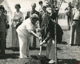
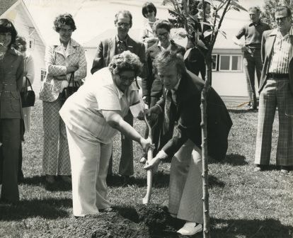
Eastburn Park tree planting
https://search.heritageburnaby.ca/link/archivedescription38626
- Repository
- City of Burnaby Archives
- Date
- June 8, 1976
- Collection/Fonds
- Burnaby Historical Society fonds
- Description Level
- Item
- Physical Description
- 1 photograph : b&w ; 20.5 x 25.5 cm pasted on cardboard backing
- Scope and Content
- Photograph of Jessie Beattie and Burnaby Mayor Tom Constable shoveling dirt onto a tree at a tree planting ceremony at Eastburn Park. Also identified in the photograph is Susan Dunn, who can be seen standing to the far left.
- Repository
- City of Burnaby Archives
- Date
- June 8, 1976
- Collection/Fonds
- Burnaby Historical Society fonds
- Subseries
- Municipal record subseries
- Physical Description
- 1 photograph : b&w ; 20.5 x 25.5 cm pasted on cardboard backing
- Description Level
- Item
- Record No.
- 467-002
- Access Restriction
- No restrictions
- Reproduction Restriction
- No restrictions
- Accession Number
- BHS2004-5
- Scope and Content
- Photograph of Jessie Beattie and Burnaby Mayor Tom Constable shoveling dirt onto a tree at a tree planting ceremony at Eastburn Park. Also identified in the photograph is Susan Dunn, who can be seen standing to the far left.
- Subjects
- Ceremonies
- Officials - Alderman and Councillors
- Officials - Mayors and Reeves
- Geographic Features - Parks
- Media Type
- Photograph
- Notes
- Title based on contents of photograph
- Geographic Access
- Eastburn Park
- 13th Avenue
- Street Address
- 7944 13th Avenue
- Historic Neighbourhood
- East Burnaby (Historic Neighbourhood)
- Planning Study Area
- Second Street Area
Images