Narrow Results By
![City of Mainz, Germany, [1880] thumbnail](/media/hpo/_Data/_Archives_Images/_Unrestricted/477/477-798.jpg?width=280)
City of Mainz, Germany
https://search.heritageburnaby.ca/link/archivedescription39479
- Repository
- City of Burnaby Archives
- Date
- [1880]
- Collection/Fonds
- Peers Family and Hill Family fonds
- Description Level
- Item
- Physical Description
- 1 photograph : b&w ; 10 x 15 cm on page 21.5 x 28 cm (pasted in album)
- Scope and Content
- Photograph of the City of Mainz in Germany. This item was in a scrapbook kept by Claude Hill who was originally from England but ultimately settled in the Burnaby Lake area.
- Repository
- City of Burnaby Archives
- Date
- [1880]
- Collection/Fonds
- Peers Family and Hill Family fonds
- Physical Description
- 1 photograph : b&w ; 10 x 15 cm on page 21.5 x 28 cm (pasted in album)
- Description Level
- Item
- Record No.
- 477-798
- Access Restriction
- No restrictions
- Reproduction Restriction
- No known restrictions
- Accession Number
- 2007-12
- Scope and Content
- Photograph of the City of Mainz in Germany. This item was in a scrapbook kept by Claude Hill who was originally from England but ultimately settled in the Burnaby Lake area.
- Media Type
- Photograph
- Notes
- Title based on contents of photograph
Images
![City of Mainz, Germany, [1880] thumbnail](/media/hpo/_Data/_Archives_Images/_Unrestricted/477/477-798.jpg)
![Snow scene at Edmonds, [190-?] (date of original), copied 1977 thumbnail](/media/hpo/_Data/_BVM_Images/1977/1977_0099_0024_001.jpg?width=280)
Snow scene at Edmonds
https://search.heritageburnaby.ca/link/museumdescription582
- Repository
- Burnaby Village Museum
- Date
- [190-?] (date of original), copied 1977
- Collection/Fonds
- Burnaby Village Museum Photograph collection
- Description Level
- Item
- Physical Description
- 1 photograph : b&w ; 20.2 x 25.2 cm print
- Scope and Content
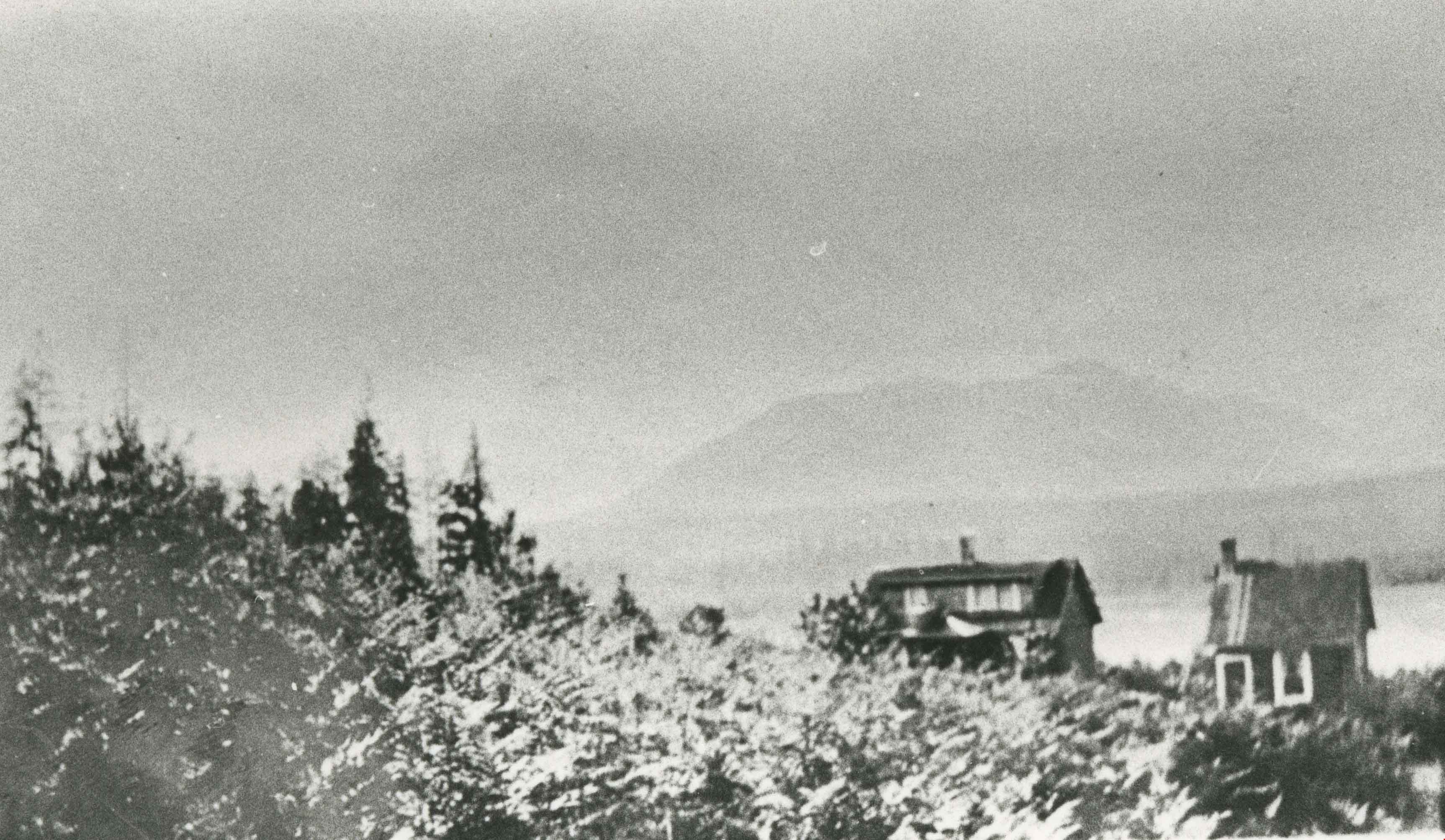
- Photograph of a snow scene taken from the porch of the Patterson house on Edmonds Street. Noted in the catalogue record is how the snow covered house in the distance was the only neighbour of the Pattersons at that time. The house was originally located at 7260 Edmonds Street (near Kingsway). It w…
- Repository
- Burnaby Village Museum
- Collection/Fonds
- Burnaby Village Museum Photograph collection
- Description Level
- Item
- Physical Description
- 1 photograph : b&w ; 20.2 x 25.2 cm print
- Scope and Content
- Photograph of a snow scene taken from the porch of the Patterson house on Edmonds Street. Noted in the catalogue record is how the snow covered house in the distance was the only neighbour of the Pattersons at that time. The house was originally located at 7260 Edmonds Street (near Kingsway). It was relocated in 1955 to 7106 18th Avenue and is a city heritage site.
- Geographic Access
- Edmonds Street
- 18th Avenue
- Street Address
- 7260 Edmonds Street
- 7106 18th Avenue
- Accession Code
- HV977.99.24
- Access Restriction
- No restrictions
- Reproduction Restriction
- May be restricted by third party rights
- Date
- [190-?] (date of original), copied 1977
- Media Type
- Photograph
- Historic Neighbourhood
- Edmonds (Historic Neighbourhood)
- Planning Study Area
- Stride Avenue Area
- Scan Resolution
- 600
- Scan Date
- 2023-07-11
- Notes
- Title based on contents of photograph
Images
![Snow scene at Edmonds, [190-?] (date of original), copied 1977 thumbnail](/media/hpo/_Data/_BVM_Images/1977/1977_0099_0024_001.jpg)

Vancouver Heights area
https://search.heritageburnaby.ca/link/archivedescription35266
- Repository
- City of Burnaby Archives
- Date
- 1911 (date of original), copied 1986
- Collection/Fonds
- Burnaby Historical Society fonds
- Description Level
- Item
- Physical Description
- 1 photograph : b&w ; 12.7 x 17.8 cm print
- Scope and Content
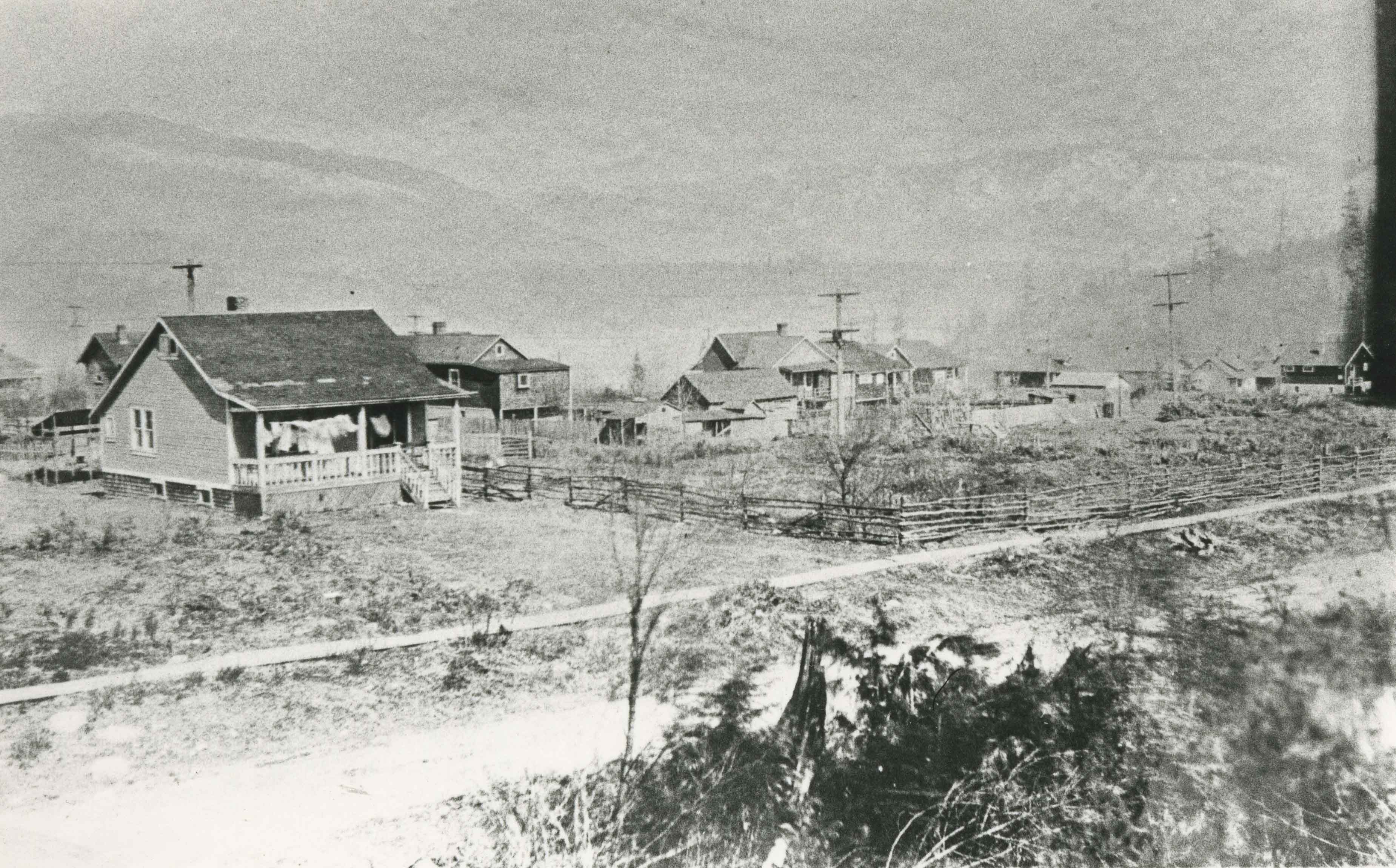
- Photograph of Carleton Avenue and Yale Street area in the neighbourhood where David Taylor and Henry Ward built their duplex for their families in 1911, when they emigrated from England. Both families had two children: Douglas and Hilda Ward, and Marjorie and Winnie Taylor.
- Repository
- City of Burnaby Archives
- Date
- 1911 (date of original), copied 1986
- Collection/Fonds
- Burnaby Historical Society fonds
- Subseries
- Pioneer Tales subseries
- Physical Description
- 1 photograph : b&w ; 12.7 x 17.8 cm print
- Description Level
- Item
- Record No.
- 204-123
- Access Restriction
- No restrictions
- Reproduction Restriction
- No known restrictions
- Accession Number
- BHS1988-03
- Scope and Content
- Photograph of Carleton Avenue and Yale Street area in the neighbourhood where David Taylor and Henry Ward built their duplex for their families in 1911, when they emigrated from England. Both families had two children: Douglas and Hilda Ward, and Marjorie and Winnie Taylor.
- Subjects
- Geographic Features - Neighbourhoods
- Media Type
- Photograph
- Notes
- Title based on contents of photograph
- Geographic Access
- Carleton Avenue
- Yale Street
- Historic Neighbourhood
- Vancouver Heights (Historic Neighbourhood)
- Planning Study Area
- Burnaby Heights Area
Images

Vancouver Heights area
https://search.heritageburnaby.ca/link/archivedescription35267
- Repository
- City of Burnaby Archives
- Date
- 1911 (date of original), copied 1986
- Collection/Fonds
- Burnaby Historical Society fonds
- Description Level
- Item
- Physical Description
- 1 photograph : b&w ; 12.7 x 17.8 cm print
- Scope and Content
- Photograph taken from the corner of Carleton Avenue and McGill Street, looking northeast. This later became the site of McGill Park.
- Repository
- City of Burnaby Archives
- Date
- 1911 (date of original), copied 1986
- Collection/Fonds
- Burnaby Historical Society fonds
- Subseries
- Pioneer Tales subseries
- Physical Description
- 1 photograph : b&w ; 12.7 x 17.8 cm print
- Description Level
- Item
- Record No.
- 204-124
- Access Restriction
- No restrictions
- Reproduction Restriction
- No known restrictions
- Accession Number
- BHS1988-03
- Scope and Content
- Photograph taken from the corner of Carleton Avenue and McGill Street, looking northeast. This later became the site of McGill Park.
- Subjects
- Geographic Features - Neighbourhoods
- Media Type
- Photograph
- Photographer
- Sutcliffe, Arthur
- Notes
- Title based on contents of photograph
- Geographic Access
- Carleton Avenue North
- McGill Park
- McGill Street
- Historic Neighbourhood
- Vancouver Heights (Historic Neighbourhood)
- Planning Study Area
- Burnaby Heights Area
Images
![Walker family home, [1912] (date of original), copied 1986 thumbnail](/media/hpo/_Data/_Archives_Images/_Unrestricted/204/204-229.jpg?width=280)
Walker family home
https://search.heritageburnaby.ca/link/archivedescription35372
- Repository
- City of Burnaby Archives
- Date
- [1912] (date of original), copied 1986
- Collection/Fonds
- Burnaby Historical Society fonds
- Description Level
- Item
- Physical Description
- 1 photograph : b&w ; 12.7 x 17.8 cm print
- Scope and Content
- Photograph of the William George Walker house at Edmonds and Kingsway, 7328 Edmonds Street, built in 1909. The houses in the background are on Linden Avenue.
- Repository
- City of Burnaby Archives
- Date
- [1912] (date of original), copied 1986
- Collection/Fonds
- Burnaby Historical Society fonds
- Subseries
- Pioneer Tales subseries
- Physical Description
- 1 photograph : b&w ; 12.7 x 17.8 cm print
- Description Level
- Item
- Record No.
- 204-229
- Access Restriction
- No restrictions
- Reproduction Restriction
- No known restrictions
- Accession Number
- BHS1988-03
- Scope and Content
- Photograph of the William George Walker house at Edmonds and Kingsway, 7328 Edmonds Street, built in 1909. The houses in the background are on Linden Avenue.
- Media Type
- Photograph
- Notes
- Title based on contents of photograph
- Geographic Access
- Edmonds Street
- Linden Avenue
- Street Address
- 7328 Edmonds Street
- Historic Neighbourhood
- Edmonds (Historic Neighbourhood)
- Planning Study Area
- Richmond Park Area
Images
![Walker family home, [1912] (date of original), copied 1986 thumbnail](/media/hpo/_Data/_Archives_Images/_Unrestricted/204/204-229.jpg)

Vancouver Heights
https://search.heritageburnaby.ca/link/archivedescription35426
- Repository
- City of Burnaby Archives
- Date
- 1913 (date of original), copied 1986
- Collection/Fonds
- Burnaby Historical Society fonds
- Description Level
- Item
- Physical Description
- 1 photograph : b&w ; 12.7 x 17.8 cm print
- Scope and Content
- Photograph of a general view of Vancouver Heights. The car is on Ingleton Avenue near the corner of Triumph Street, looking east to MacDonald Avenue and Gilmore Avenue. Vancouver Heights Presbyterian Church and Gilmore Avenue School can be seen in the background at the right. The photograph is by D…
- Repository
- City of Burnaby Archives
- Date
- 1913 (date of original), copied 1986
- Collection/Fonds
- Burnaby Historical Society fonds
- Subseries
- Pioneer Tales subseries
- Physical Description
- 1 photograph : b&w ; 12.7 x 17.8 cm print
- Description Level
- Item
- Record No.
- 204-284
- Access Restriction
- No restrictions
- Reproduction Restriction
- No restrictions
- Accession Number
- BHS1988-03
- Scope and Content
- Photograph of a general view of Vancouver Heights. The car is on Ingleton Avenue near the corner of Triumph Street, looking east to MacDonald Avenue and Gilmore Avenue. Vancouver Heights Presbyterian Church and Gilmore Avenue School can be seen in the background at the right. The photograph is by Dr. Carl Eaton, teacher, principal and later family physician.
- Media Type
- Photograph
- Photographer
- Eaton, Dr. Carl
- Notes
- Title based on contents of photograph
- Geographic Access
- Ingleton Avenue
- MacDonald Avenue
- Triumph Street
- Historic Neighbourhood
- Vancouver Heights (Historic Neighbourhood)
- Planning Study Area
- Willingdon Heights Area
Images

![Barnet Village, [1915] (date of original), copied 1986 thumbnail](/media/hpo/_Data/_Archives_Images/_Unrestricted/204/204-295.jpg?width=280)
Barnet Village
https://search.heritageburnaby.ca/link/archivedescription35437
- Repository
- City of Burnaby Archives
- Date
- [1915] (date of original), copied 1986
- Collection/Fonds
- Burnaby Historical Society fonds
- Description Level
- Item
- Physical Description
- 1 photograph : b&w ; 12.7 x 17.8 cm print
- Scope and Content
- Photograph of workers' houses in Barnet Village. Some 700 people were employed by the North Pacific Lumber Co. mill at its peak. The roof of the Canadian Pacific Railway station is visible.
- Repository
- City of Burnaby Archives
- Date
- [1915] (date of original), copied 1986
- Collection/Fonds
- Burnaby Historical Society fonds
- Subseries
- Pioneer Tales subseries
- Physical Description
- 1 photograph : b&w ; 12.7 x 17.8 cm print
- Description Level
- Item
- Record No.
- 204-295
- Access Restriction
- No restrictions
- Reproduction Restriction
- No restrictions
- Accession Number
- BHS1988-03
- Scope and Content
- Photograph of workers' houses in Barnet Village. Some 700 people were employed by the North Pacific Lumber Co. mill at its peak. The roof of the Canadian Pacific Railway station is visible.
- Subjects
- Geographic Features - Neighbourhoods
- Media Type
- Photograph
- Photographer
- Eaton, Dr. Carl
- Notes
- Title based on contents of photograph
- Geographic Access
- Barnet Road
- Street Address
- 8181 Barnet Road
- Historic Neighbourhood
- Barnet (Historic Neighbourhood)
- Planning Study Area
- Burnaby Mountain Area
Images
![Barnet Village, [1915] (date of original), copied 1986 thumbnail](/media/hpo/_Data/_Archives_Images/_Unrestricted/204/204-295.jpg)
![Barnet Village, [1915] (date of original), copied 1986 thumbnail](/media/hpo/_Data/_Archives_Images/_Unrestricted/204/204-296.jpg?width=280)
Barnet Village
https://search.heritageburnaby.ca/link/archivedescription35438
- Repository
- City of Burnaby Archives
- Date
- [1915] (date of original), copied 1986
- Collection/Fonds
- Burnaby Historical Society fonds
- Description Level
- Item
- Physical Description
- 1 photograph : b&w ; 12.7 x 17.8 cm print
- Scope and Content
- Photograph of workers' houses in Barnet Village. Some 700 people were employed by the North Pacific Lumber Co. mill at its peak.
- Repository
- City of Burnaby Archives
- Date
- [1915] (date of original), copied 1986
- Collection/Fonds
- Burnaby Historical Society fonds
- Subseries
- Pioneer Tales subseries
- Physical Description
- 1 photograph : b&w ; 12.7 x 17.8 cm print
- Description Level
- Item
- Record No.
- 204-296
- Access Restriction
- No restrictions
- Reproduction Restriction
- No restrictions
- Accession Number
- BHS1988-03
- Scope and Content
- Photograph of workers' houses in Barnet Village. Some 700 people were employed by the North Pacific Lumber Co. mill at its peak.
- Media Type
- Photograph
- Photographer
- Eaton, Dr. Carl
- Notes
- Title based on contents of photograph
- Geographic Access
- Barnet Road
- Street Address
- 8383 Barnet Road
- Historic Neighbourhood
- Barnet (Historic Neighbourhood)
- Planning Study Area
- Burnaby Mountain Area
Images
![Barnet Village, [1915] (date of original), copied 1986 thumbnail](/media/hpo/_Data/_Archives_Images/_Unrestricted/204/204-296.jpg)

Interview with Judy Hagen by Eric Damer November 7, 2012 - Track 1
https://search.heritageburnaby.ca/link/oralhistory332
- Repository
- City of Burnaby Archives
- Date Range
- 1918-1948
- Length
- 0:09:53
- Summary
- This portion of the recording pertains to Judith "Judy" (Robins) Hagen's views on the neighbourhood of Dover Street in Burnaby. She begins by discussing how her family first arrived on Dover Street (when her father Jack Robins was only two years old) and continues their story through her childhood …
- Repository
- City of Burnaby Archives
- Summary
- This portion of the recording pertains to Judith "Judy" (Robins) Hagen's views on the neighbourhood of Dover Street in Burnaby. She begins by discussing how her family first arrived on Dover Street (when her father Jack Robins was only two years old) and continues their story through her childhood during the war years, including neighbours and neighbouring buildings.
- Date Range
- 1918-1948
- Photo Info
- Judith "Judy" Robins (later Hagen) posing in a dance costume, 1949. Item no. 549-036.
- Length
- 0:09:53
- Subjects
- Geographic Features - Neighbourhoods
- Geographic Access
- Dover Street
- Interviewer
- Damer, Eric
- Interview Date
- November 7, 2012
- Scope and Content
- Recording is an interview with Judith "Judy" (Robins) Hagen conducted by Burnaby Village Museum employee Eric Damer, November 7, 2012. Major theme discussed: the neighbourhood of Dover Street.
- Biographical Notes
- Judy Robins (later Hagen) was born in 1941 and grew up in South Burnaby. Her paternal grandfather, a master stone mason from Devon, moved to Vancouver in 1912 to find work before bringing over the rest of the family. He bought three lots in Burnaby and in 1918 moved his family to a small house on Dover Street (formerly Paul Street). Judy’s father, Jack, married, bought one of his father’s lots and built a new home for his family. Judy attended school and church nearby, took dance and piano lessons and participated actively in Girl Guides. After high school, she attended the University of British Columbia (UBC) and then Simon Fraser University (SFU), worked for a few years and then married in 1967 before moving to Courtaney, British Columbia.
- Total Tracks
- 7
- Total Length
- 1:09:51
- Interviewee Name
- Hagen, Judith "Judy" Robins
- Interview Location
- Nanaimo Museum on Vancouver Island
- Interviewer Bio
- Eric Damer is a lifelong British Columbian born in Victoria, raised in Kamloops, and currently residing in Burnaby. After studying philosophy at the University of Victoria, he became interested in the educational forces that had shaped his own life. He completed master’s and doctoral degrees in educational studies at the University of British Columbia with a particular interest in the history of adult and higher education in the province. In 2012, Eric worked for the City of Burnaby as a field researcher and writer, conducting interviews for the City Archives and Museum Oral History Program.
- Collection/Fonds
- Community Heritage Commission Special Projects fonds
- Transcript Available
- None
- Media Type
- Sound Recording
Images

Audio Tracks
Track one of recording of interview with Judy Hagen
Track one of recording of interview with Judy Hagen
https://search.heritageburnaby.ca/media/hpo/_Data/_Archives_Oral_Histories/_Unrestricted/MSS171-011/MSS171-011_Track_1.mp3![Vancouver Heights, [1920] thumbnail](/media/hpo/_Data/_Archives_Images/_Unrestricted/371/381-001.jpg?width=280)
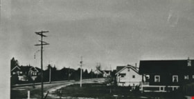
Vancouver Heights
https://search.heritageburnaby.ca/link/archivedescription38274
- Repository
- City of Burnaby Archives
- Date
- [1920]
- Collection/Fonds
- Burnaby Historical Society fonds
- Description Level
- Item
- Physical Description
- 1 photograph : sepia ; 12.5 x 18 cm
- Scope and Content
- Photograph of three houses in the Vancouver Heights area, North Burnaby. The exact location of this photograph is unknown.
- Repository
- City of Burnaby Archives
- Date
- [1920]
- Collection/Fonds
- Burnaby Historical Society fonds
- Subseries
- Photographs subseries
- Physical Description
- 1 photograph : sepia ; 12.5 x 18 cm
- Description Level
- Item
- Record No.
- 381-001
- Access Restriction
- No restrictions
- Reproduction Restriction
- No known restrictions
- Accession Number
- BHS2007-04
- Scope and Content
- Photograph of three houses in the Vancouver Heights area, North Burnaby. The exact location of this photograph is unknown.
- Subjects
- Geographic Features - Neighbourhoods
- Media Type
- Photograph
- Notes
- Title based on contents of photograph.
- Historic Neighbourhood
- Vancouver Heights (Historic Neighbourhood)
- Planning Study Area
- Burnaby Heights Area
Images
![Vancouver Heights, [1920] thumbnail](/media/hpo/_Data/_Archives_Images/_Unrestricted/371/381-001.jpg)
Capitol Hill neighborhood
https://search.heritageburnaby.ca/link/archivedescription35792
- Repository
- City of Burnaby Archives
- Date
- 1923 (date of original), copied 1986
- Collection/Fonds
- Burnaby Historical Society fonds
- Description Level
- Item
- Physical Description
- 1 photograph : b&w ; 12.7 x 17.8 cm print
- Scope and Content
- Photograph of the Capitol Hill neighborhood taken from Bob Benson's home, 5 Fell Avenue and Dundas Street, looking towards the top of Capitol Hill.
- Repository
- City of Burnaby Archives
- Date
- 1923 (date of original), copied 1986
- Collection/Fonds
- Burnaby Historical Society fonds
- Subseries
- Pioneer Tales subseries
- Physical Description
- 1 photograph : b&w ; 12.7 x 17.8 cm print
- Description Level
- Item
- Record No.
- 204-650
- Access Restriction
- No restrictions
- Reproduction Restriction
- No known restrictions
- Accession Number
- BHS1988-03
- Scope and Content
- Photograph of the Capitol Hill neighborhood taken from Bob Benson's home, 5 Fell Avenue and Dundas Street, looking towards the top of Capitol Hill.
- Media Type
- Photograph
- Notes
- Title based on contents of photograph
- Geographic Access
- Fell Avenue
- Street Address
- 5 Fell Avenue
- Historic Neighbourhood
- Capitol Hill (Historic Neighbourhood)
- Planning Study Area
- Capitol Hill Area
Images

Interview with Jack McGeachie June 18, 1975 - Track 3
https://search.heritageburnaby.ca/link/oralhistory37
- Repository
- City of Burnaby Archives
- Date Range
- 1925
- Length
- 0:07:37
- Summary
- This portion of the interview pertains to John Aloysius "Jack" McGeachie's impressions of the neighbourhood he grew up in.
- Repository
- City of Burnaby Archives
- Summary
- This portion of the interview pertains to John Aloysius "Jack" McGeachie's impressions of the neighbourhood he grew up in.
- Date Range
- 1925
- Photo Info
- McGeachie family; John Aloysius "Jack" McGeachie is the eldest child, standing second from the right, 1925 (date of original). Item no. 204-464
- Length
- 0:07:37
- Historic Neighbourhood
- Edmonds (Historic Neighbourhood)
- Planning Study Area
- Richmond Park Area
- Interviewer
- Bradbury, Dr. Bettina
- Interview Date
- June 18, 1975
- Scope and Content
- Recording is a taped interview with John A."Jack" McGeachie by SFU (Simon Fraser University) graduate student Bettina Bradbury June 18, 1975. Major themes discussed are: the Depression, the CCF (Co-operative Commonwealth Federation) and farming in Burnaby. To view "Narrow By" terms for each track expand this description and see "Notes".
- Biographical Notes
- John Aloysius “Jack” McGeachie was born January 14, 1914 in Little Mountain, Vancouver to Helen and John McGeachie. Helen and John had four children; John Aloysius “Jack”, Florence Mary, Thomas Joseph “Tom” and Roderick Noel “Rod.” In 1922 the McGeachie family moved from Vancouver to East Burnaby where the children attended Edmonds School. John Sr. became ill and died, leaving the eldest Jack as the main breadwinner of the family when he was still just a teenager. He began his working life at a chicken farm, later learning his trade while working for the Hudson Bay Company. Jack McGeachie married Burnaby Historian Doreen Pixie Johnson. He and Pixie raised their children Kathi (Dunlop) and David McGeachie in the house the couple built themselves in 1947. John Aloysius "Jack" McGeachie died October 12, 1981 at the age of sixty-seven. Doreen "Pixie" (Johnson) McGeachie died August 14, 2010 at the age of eighty-nine.
- Total Tracks
- 8
- Total Length
- 0:51:13
- Interviewee Name
- McGeachie, John Aloysius "Jack"
- Interview Location
- Rosewood
- Interviewer Bio
- Bettina Bradbury teaches history and women's studies at York University. She is the author of Wife to Widow. Lives, Laws and Politics in Nineteenth-century Montreal. (Vancouver: University of British Columbia Press, June 2011), 520p; Working Families. Age, Gender and Daily Survival in Industrializing Montreal. (Toronto: Canadian Social History Series, McClelland and Stewart, 1993); (Republished Toronto: Oxford University Press, 1996) (3rd edition, Toronto: University of Toronto Press, 2007). These interviews were undertaken after she completed her MA at Simon Fraser University in 1975 with the support of an LIP grant.
- Collection/Fonds
- Burnaby Historical Society fonds
- Subseries
- Oral history subseries
- Transcript Available
- None
- Media Type
- Sound Recording
- Web Notes
- Interview was digitized in 2010 allowing it to be accessible on Heritage Burnaby. The digitization project was initiated by the Community Heritage Commission with support from City of Burnaby Council and the BC History Digitization Program of the Irving K. Barber Learning Centre, University of British Columbia. It was recognized by the Heritage Society of BC with an award in 2012.
Images

Audio Tracks
Track one of interview with Jack McGeachie
Track one of interview with Jack McGeachie
https://search.heritageburnaby.ca/media/hpo/_Data/_Archives_Oral_Histories/_Unrestricted/100-13-10/100-13-10_Track_3.mp3![Hazel (Bongea) Padula standing on the steps of her home at High Lawn, [195-]. Item no. 549-052. thumbnail](/media/hpo/_Data/_Archives_Images/_Unrestricted/540/549-052.jpg?width=280)
Interview with Tony and Hazel Padula by Eric Damer November 27, 2012 - Track 2
https://search.heritageburnaby.ca/link/oralhistory372
- Repository
- City of Burnaby Archives
- Date Range
- 1926-1958
- Length
- 0:11:29
- Summary
- This portion of the recording pertains to Tony Padula and Hazel (Bongea) Padula's memories of their first home in Burnaby. Tony and Hazel discuss their house, their neighbourhood and their neighbours. Tony also tells the story of his family first coming to Burnaby from Italy.
- Repository
- City of Burnaby Archives
- Summary
- This portion of the recording pertains to Tony Padula and Hazel (Bongea) Padula's memories of their first home in Burnaby. Tony and Hazel discuss their house, their neighbourhood and their neighbours. Tony also tells the story of his family first coming to Burnaby from Italy.
- Date Range
- 1926-1958
- Photo Info
- Hazel (Bongea) Padula standing on the steps of her home at High Lawn, [195-]. Item no. 549-052.
- Length
- 0:11:29
- Planning Study Area
- Brentwood Area
- Interviewer
- Damer, Eric
- Interview Date
- November 27, 2012
- Scope and Content
- Recording is an interview with Tony Padula and Hazel (Bongea) Padula conducted by Burnaby Village Museum employee Eric Damer, November 27, 2012. Major themes discussed are: neighbourhoods and family heritage.
- Biographical Notes
- Tony Padula’s family came to Vancouver from Italy in 1926, the year Tony was born. After graduating from school, Tony entered the shoe industry as a salesman. Hazel Bongea (later Padula) was born in 1931 in Saskatchewan and moved to Vancouver with her family when she was ten years old. After graduating from school, Hazel found work with Standard Oil in Vancouver. Tony Padula and Hazel (Bongea) Padula married in 1951. By 1953 they had bought property in the Brentwood neighbourhood of Burnaby where they built a home and began a family. The Padulas moved away in 1959 but returned five years later to a new home in central Burnaby, where they lived for twenty-two years before moving again, this time to North Vancouver. After six years in North Vancouver, Tony and Hazel retired to New Westminster.
- Total Tracks
- 8
- Total Length
- 1:09:21
- Interviewee Name
- Padula, Hazel Bongea
- Padula, Tony
- Interview Location
- Burnaby Village Museum
- Interviewer Bio
- Eric Damer is a lifelong British Columbian born in Victoria, raised in Kamloops, and currently residing in Burnaby. After studying philosophy at the University of Victoria, he became interested in the educational forces that had shaped his own life. He completed master’s and doctoral degrees in educational studies at the University of British Columbia with a particular interest in the history of adult and higher education in the province. In 2012, Eric worked for the City of Burnaby as a field researcher and writer, conducting interviews for the City Archives and Museum Oral History Program.
- Collection/Fonds
- Community Heritage Commission Special Projects fonds
- Transcript Available
- None
- Media Type
- Sound Recording
Images
![Hazel (Bongea) Padula standing on the steps of her home at High Lawn, [195-]. Item no. 549-052. thumbnail](/media/hpo/_Data/_Archives_Images/_Unrestricted/540/549-052.jpg)
Audio Tracks
Track two of recording of interview with Tony and Hazel Padula
Track two of recording of interview with Tony and Hazel Padula
https://search.heritageburnaby.ca/media/hpo/_Data/_Archives_Oral_Histories/_Unrestricted/MSS171-020/MSS171-020_Track_2.mp3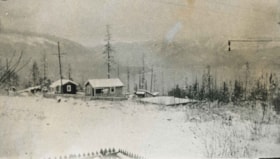
Benson Neighbourhood
https://search.heritageburnaby.ca/link/archivedescription35582
- Repository
- City of Burnaby Archives
- Date
- 1929 (date of original), copied 1986
- Collection/Fonds
- Burnaby Historical Society fonds
- Description Level
- Item
- Physical Description
- 1 photograph : b&w ; 12.7 x 17.8 cm print
- Scope and Content
- Photograph of the neighbourhood as seen from the Benson front porch at 3 Fell Avenue North. Note the trees and bush.
- Repository
- City of Burnaby Archives
- Date
- 1929 (date of original), copied 1986
- Collection/Fonds
- Burnaby Historical Society fonds
- Subseries
- Pioneer Tales subseries
- Physical Description
- 1 photograph : b&w ; 12.7 x 17.8 cm print
- Description Level
- Item
- Record No.
- 204-440
- Access Restriction
- No restrictions
- Reproduction Restriction
- No known restrictions
- Accession Number
- BHS1988-03
- Scope and Content
- Photograph of the neighbourhood as seen from the Benson front porch at 3 Fell Avenue North. Note the trees and bush.
- Subjects
- Geographic Features - Neighbourhoods
- Media Type
- Photograph
- Notes
- Title based on contents of photograph
- Geographic Access
- Fell Avenue
- Historic Neighbourhood
- Capitol Hill (Historic Neighbourhood)
- Planning Study Area
- Capitol Hill Area
Images
Davis family neighbourhood
https://search.heritageburnaby.ca/link/archivedescription35610
- Repository
- City of Burnaby Archives
- Date
- 1929 (date of original), copied 1986
- Collection/Fonds
- Burnaby Historical Society fonds
- Description Level
- Item
- Physical Description
- 1 photograph : b&w ; 10.2 x 17.8 cm print
- Scope and Content
- Photograph of the neighbourhood where the Davis family lived, looking up Royal Oak Road at Imperial Street, taken from an upstairs room of the Davis home. Arthur Davis later built a corner house at 2345 Royal Oak, right next to house from which this photograph was taken.
- Repository
- City of Burnaby Archives
- Date
- 1929 (date of original), copied 1986
- Collection/Fonds
- Burnaby Historical Society fonds
- Subseries
- Pioneer Tales subseries
- Physical Description
- 1 photograph : b&w ; 10.2 x 17.8 cm print
- Description Level
- Item
- Record No.
- 204-468
- Access Restriction
- No restrictions
- Reproduction Restriction
- No known restrictions
- Accession Number
- BHS1988-03
- Scope and Content
- Photograph of the neighbourhood where the Davis family lived, looking up Royal Oak Road at Imperial Street, taken from an upstairs room of the Davis home. Arthur Davis later built a corner house at 2345 Royal Oak, right next to house from which this photograph was taken.
- Subjects
- Geographic Features - Neighbourhoods
- Media Type
- Photograph
- Notes
- Title based on contents of photograph
- Photograph has been cropped
- Geographic Access
- Royal Oak Avenue
- Historic Neighbourhood
- Central Park (Historic Neighbourhood)
- Planning Study Area
- Windsor Area
Images
![In the neighbourhood, [194-] (date of original), copied 1976 thumbnail](/media/hpo/_Data/_BVM_Images/1974/197602510030.jpg?width=280)
In the neighbourhood
https://search.heritageburnaby.ca/link/museumdescription1625
- Repository
- Burnaby Village Museum
- Date
- [194-] (date of original), copied 1976
- Collection/Fonds
- Burnaby Village Museum Photograph collection
- Description Level
- Item
- Physical Description
- 1 photograph : col. negative ; 4.5 x 6.5 cm
- Scope and Content
- Photograph of an elderly woman standing on a pavement sidewalk beside Regent Street. The tall house in the background is the McCallum house facing Regent Street, and other houses on the right side facing the road. There is an unpaved footpath closer to the houses. Electric poles are erected along t…
- Repository
- Burnaby Village Museum
- Collection/Fonds
- Burnaby Village Museum Photograph collection
- Description Level
- Item
- Physical Description
- 1 photograph : col. negative ; 4.5 x 6.5 cm
- Scope and Content
- Photograph of an elderly woman standing on a pavement sidewalk beside Regent Street. The tall house in the background is the McCallum house facing Regent Street, and other houses on the right side facing the road. There is an unpaved footpath closer to the houses. Electric poles are erected along the road on a grassy patch between the pavement sidewalk and the foot path.
- Subjects
- Geographic Features - Neighbourhoods
- Accession Code
- HV976.251.30
- Access Restriction
- No restrictions
- Reproduction Restriction
- May be restricted by third party rights
- Date
- [194-] (date of original), copied 1976
- Media Type
- Photograph
- Related Material
- For another photograph of the elderly lady, see HV976.251.28
- Scan Resolution
- 300
- Scan Date
- 22/8/2006
- Scale
- 100
- Notes
- Title based on contents of photograph
- The print is made as a black and white print from a colour negative film
Images
![In the neighbourhood, [194-] (date of original), copied 1976 thumbnail](/media/hpo/_Data/_BVM_Images/1974/197602510030.jpg)
![North Burnaby from Hythe Avenue, [1949] thumbnail](/media/hpo/_Data/_Archives_Images/_Unrestricted/126/161-004.jpg?width=280)
North Burnaby from Hythe Avenue
https://search.heritageburnaby.ca/link/archivedescription34929
- Repository
- City of Burnaby Archives
- Date
- [1949]
- Collection/Fonds
- Burnaby Historical Society fonds
- Description Level
- Item
- Physical Description
- 1 photograph : b&w ; 9.1 x 12.6 cm
- Scope and Content
- Photograph taken looking west from Hythe Avenue, between Empire Drive and Dundas, towards north Burnaby.
- Repository
- City of Burnaby Archives
- Date
- [1949]
- Collection/Fonds
- Burnaby Historical Society fonds
- Subseries
- Marjorie Coe subseries
- Physical Description
- 1 photograph : b&w ; 9.1 x 12.6 cm
- Description Level
- Item
- Record No.
- 161-004
- Access Restriction
- No restrictions
- Reproduction Restriction
- Reproduce for fair dealing purposes only
- Accession Number
- BHS1986-11
- Scope and Content
- Photograph taken looking west from Hythe Avenue, between Empire Drive and Dundas, towards north Burnaby.
- Subjects
- Geographic Features - Neighbourhoods
- Media Type
- Photograph
- Notes
- Title based on contents of photograph
- Item no. 161-004, 161-005 and 161-006 join to form a panorama
- Geographic Access
- Hythe Avenue
- Historic Neighbourhood
- Capitol Hill (Historic Neighbourhood)
- Planning Study Area
- Capitol Hill Area
Images
![North Burnaby from Hythe Avenue, [1949] thumbnail](/media/hpo/_Data/_Archives_Images/_Unrestricted/126/161-004.jpg)
![North Burnaby from Hythe Avenue, [1949] thumbnail](/media/hpo/_Data/_Archives_Images/_Unrestricted/126/161-005.jpg?width=280)
North Burnaby from Hythe Avenue
https://search.heritageburnaby.ca/link/archivedescription34930
- Repository
- City of Burnaby Archives
- Date
- [1949]
- Collection/Fonds
- Burnaby Historical Society fonds
- Description Level
- Item
- Physical Description
- 1 photograph : b&w ; 8.9 x 12.6 cm
- Scope and Content
- Photograph taken looking west from Hythe Avenue towards north Burnaby.
- Repository
- City of Burnaby Archives
- Date
- [1949]
- Collection/Fonds
- Burnaby Historical Society fonds
- Subseries
- Marjorie Coe subseries
- Physical Description
- 1 photograph : b&w ; 8.9 x 12.6 cm
- Description Level
- Item
- Record No.
- 161-005
- Access Restriction
- No restrictions
- Reproduction Restriction
- Reproduce for fair dealing purposes only
- Accession Number
- BHS1986-11
- Scope and Content
- Photograph taken looking west from Hythe Avenue towards north Burnaby.
- Subjects
- Geographic Features - Neighbourhoods
- Media Type
- Photograph
- Notes
- Title based on contents of photograph
- Items no. 161-004, 161-005 and 161-006 join to form a panorama
- Geographic Access
- Hythe Avenue
- Historic Neighbourhood
- Capitol Hill (Historic Neighbourhood)
- Planning Study Area
- Capitol Hill Area
Images
![North Burnaby from Hythe Avenue, [1949] thumbnail](/media/hpo/_Data/_Archives_Images/_Unrestricted/126/161-005.jpg)
![North Burnaby from Hythe Avenue, [1949] thumbnail](/media/hpo/_Data/_Archives_Images/_Unrestricted/126/161-006.jpg?width=280)
North Burnaby from Hythe Avenue
https://search.heritageburnaby.ca/link/archivedescription34931
- Repository
- City of Burnaby Archives
- Date
- [1949]
- Collection/Fonds
- Burnaby Historical Society fonds
- Description Level
- Item
- Physical Description
- 1 photograph : b&w ; 8.9 x 12.6 cm
- Scope and Content
- Photograph taken looking west from Hythe Avenue towards north Burnaby. Burrard Inlet is also visible.
- Repository
- City of Burnaby Archives
- Date
- [1949]
- Collection/Fonds
- Burnaby Historical Society fonds
- Subseries
- Marjorie Coe subseries
- Physical Description
- 1 photograph : b&w ; 8.9 x 12.6 cm
- Description Level
- Item
- Record No.
- 161-006
- Access Restriction
- No restrictions
- Reproduction Restriction
- Reproduce for fair dealing purposes only
- Accession Number
- BHS1986-11
- Scope and Content
- Photograph taken looking west from Hythe Avenue towards north Burnaby. Burrard Inlet is also visible.
- Media Type
- Photograph
- Notes
- Title based on contents of photograph
- Items no. 161-004, 161-005 and 161-006 join to form a panorama
- Geographic Access
- Hythe Avenue
- Historic Neighbourhood
- Capitol Hill (Historic Neighbourhood)
- Planning Study Area
- Capitol Hill Area
Images
![North Burnaby from Hythe Avenue, [1949] thumbnail](/media/hpo/_Data/_Archives_Images/_Unrestricted/126/161-006.jpg)
Interview with Diane Stiglish by Eric Damer December 4, 2012 - Track 5
https://search.heritageburnaby.ca/link/oralhistory413
- Repository
- City of Burnaby Archives
- Date Range
- 1950-2012
- Length
- 0:08:57
- Summary
- This portion of the recording pertains to Diane Stiglish's memories of the neighbourhood she grew up in and the changes that have occurred there. Diane describes how her parents sold the mushroom farm and built a new home; the property later became a townhouse development. She mentions her brother …
- Repository
- City of Burnaby Archives
- Summary
- This portion of the recording pertains to Diane Stiglish's memories of the neighbourhood she grew up in and the changes that have occurred there. Diane describes how her parents sold the mushroom farm and built a new home; the property later became a townhouse development. She mentions her brother and some of their early neighbours.
- Date Range
- 1950-2012
- Photo Info
- Diane Stiglish with her parents and older brother in New Westminster, 1955. Item no. 549-067.
- Length
- 0:08:57
- Subjects
- Geographic Features - Neighbourhoods
- Historic Neighbourhood
- Burquitlam (Historic Neighbourhood)
- Interviewer
- Damer, Eric
- Interview Date
- December 4, 2012
- Scope and Content
- Recording is an interview with Diane Stiglish conducted by Burnaby Village Museum employee Eric Damer, December 4, 2012. Major theme discussed: mushroom farming.
- Biographical Notes
- F.J. "Jack" Stiglish (originally spelt Stiglich) and his wife bought a Burnaby home in 1943 at Keswick Street, just south of the Lougheed Highway, and took up mushroom farming. By the time their daughter Diane was born five years later in New Westminster, the F.J. Stiglish mushroom farm was an established business. Mushrooms grown at the F.J. Stiglish farm were sent off to Money’s Mushrooms to be packaged and retailed. Later, mushroom growers bought out Money’s to form the Fraser Valley Mushroom Growers Co-op and nominated Jack Stiglish as their first president. Jack then entered a float in the Pacific National Exhibition (PNE) parade and set up a mushroom booth at the fair. In 1969 Jack Stiglish sold the mushroom farm and he and his wife moved next to their trailer court business just down the road. Diane’s brother Allan Stiglich (his family name returned to the original spelling) moved to Langley to open a large mushroom farm of his own which he established with the help of his father. Diane Stiglish began a career with BC Tel.
- Total Tracks
- 5
- Total Length
- 0:46:06
- Interviewee Name
- Stiglish, Diane
- Interview Location
- Burnaby Village Museum
- Interviewer Bio
- Eric Damer is a lifelong British Columbian born in Victoria, raised in Kamloops, and currently residing in Burnaby. After studying philosophy at the University of Victoria, he became interested in the educational forces that had shaped his own life. He completed master’s and doctoral degrees in educational studies at the University of British Columbia with a particular interest in the history of adult and higher education in the province. In 2012, Eric worked for the City of Burnaby as a field researcher and writer, conducting interviews for the City Archives and Museum Oral History Program.
- Collection/Fonds
- Community Heritage Commission Special Projects fonds
- Transcript Available
- None
- Media Type
- Sound Recording
Images

Audio Tracks
Track five of recording of interview with Diane Stiglish
Track five of recording of interview with Diane Stiglish
https://search.heritageburnaby.ca/media/hpo/_Data/_Archives_Oral_Histories/_Unrestricted/MSS171-026/MSS171-026_Track_5.mp3