![Byrne Creek Streamkeepers, [2001] thumbnail](/media/hpo/_Data/_Archives_Images/_Unrestricted/535/535-2194-1.jpg?width=280)
Byrne Creek Streamkeepers
https://search.heritageburnaby.ca/link/archivedescription96572
- Repository
- City of Burnaby Archives
- Date
- [2001]
- Collection/Fonds
- Burnaby NewsLeader photograph collection
- Description Level
- File
- Physical Description
- 2 photographs (tiff) : col.
- Scope and Content
- File contains members of the Byrne Creek Streamkeepers during their work to protect the waterways and salmon in the area. Photographs depict Bob Fuller checking a waterflow measuring gauge and Joan Carne standing in the overflow channel at the salmon rearing ponds below Marine Drive.
- Repository
- City of Burnaby Archives
- Date
- [2001]
- Collection/Fonds
- Burnaby NewsLeader photograph collection
- Physical Description
- 2 photographs (tiff) : col.
- Description Level
- File
- Record No.
- 535-2194
- Access Restriction
- No restrictions
- Reproduction Restriction
- No restrictions
- Accession Number
- 2018-12
- Scope and Content
- File contains members of the Byrne Creek Streamkeepers during their work to protect the waterways and salmon in the area. Photographs depict Bob Fuller checking a waterflow measuring gauge and Joan Carne standing in the overflow channel at the salmon rearing ponds below Marine Drive.
- Subjects
- Persons - Volunteers
- Geographic Features - Creeks
- Geographic Features - Lakes and Ponds
- Geographic Features - Streams
- Media Type
- Photograph
- Photographer
- Bartel, Mario
- Notes
- Title based on caption
- Collected by editorial for use in a March 2001 issue of the Burnaby NewsLeader
- Caption from metadata for 535-2194-1: "Bob Fuller, of the Byrne Creek Streamkeepers, checks the guage that measures the flow of water which is released from the holding pond below Marine Drive to the salmon spawning beds downstream."
- Caption from metadata for 535-2194-2: "Joan Carne of the Byrne Creek Streamkeepers stands in the overflow channel at the salmon rearing ponds below Marine Drive. Although last week's chemical spill into Byrne Creek didn't reach the ponds, Carne says it's a constant battle to educate people to take care of the area's creeks and streams."
- Geographic Access
- Marine Drive
- Byrne Creek
- Planning Study Area
- Stride Hill Area
Images
![Byrne Creek Streamkeepers, [2001] thumbnail](/media/hpo/_Data/_Archives_Images/_Unrestricted/535/535-2194-1.jpg)
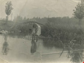
Kitty Hill wading in Deer Lake
https://search.heritageburnaby.ca/link/archivedescription39424
- Repository
- City of Burnaby Archives
- Date
- 1910
- Collection/Fonds
- Peers Family and Hill Family fonds
- Description Level
- Item
- Physical Description
- 1 photograph : b&w ; 7.2 x 10 cm
- Scope and Content
- Photograph of Kitty Hill wading in a small shallow creek. She has her feet submerged, and is dipping her hand in the water while looking up at the photographer. Just behind her is a small log bridge built over the creek, behind which can be seen a street lined with power poles, and a house in the …
- Repository
- City of Burnaby Archives
- Date
- 1910
- Collection/Fonds
- Peers Family and Hill Family fonds
- Physical Description
- 1 photograph : b&w ; 7.2 x 10 cm
- Description Level
- Item
- Record No.
- 477-743
- Access Restriction
- No restrictions
- Reproduction Restriction
- No known restrictions
- Accession Number
- 2007-12
- Scope and Content
- Photograph of Kitty Hill wading in a small shallow creek. She has her feet submerged, and is dipping her hand in the water while looking up at the photographer. Just behind her is a small log bridge built over the creek, behind which can be seen a street lined with power poles, and a house in the far distance, identified as "Broadview". An annotation on the back of the photo reads, "Kitty Hill 1910."
- Media Type
- Photograph
- Notes
- Title based on caption accompanying photograph
- Geographic Access
- Buckingham Avenue
- Deer Lake
- Street Address
- 5730 Buckingham Avenue
- Historic Neighbourhood
- Burnaby Lake (Historic Neighbourhood)
- Planning Study Area
- Morley-Buckingham Area
Images
