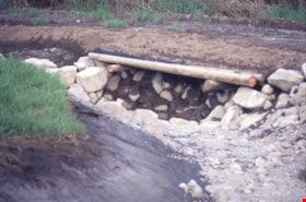
Beaver Creek - Royal Oak Avenue
https://search.heritageburnaby.ca/link/archivedescription91582
- Repository
- City of Burnaby Archives
- Date
- August 9, 1996
- Collection/Fonds
- Doreen Lawson fonds
- Description Level
- File
- Physical Description
- 13 photographs : col. slides ; 35 mm
- Scope and Content
- File consists of photographs of Beaver Creek and Royal Oak Avenue taken during the Royal Oak Avenue Realignment project.
- Repository
- City of Burnaby Archives
- Date
- August 9, 1996
- Collection/Fonds
- Doreen Lawson fonds
- Physical Description
- 13 photographs : col. slides ; 35 mm
- Description Level
- File
- Record No.
- 605-015
- Access Restriction
- No restrictions
- Reproduction Restriction
- No restrictions
- Accession Number
- 2003-30
- Scope and Content
- File consists of photographs of Beaver Creek and Royal Oak Avenue taken during the Royal Oak Avenue Realignment project.
- Subjects
- Geographic Features - Creeks
- Names
- Lawson, Doreen A.
- Media Type
- Photograph
- Photographer
- Lawson, Doreen A.
- Notes
- Title based on contents of photographs
- Geographic Access
- Deer Lake Park
- Historic Neighbourhood
- Burnaby Lake (Historic Neighbourhood)
- Planning Study Area
- Oakalla Area
Images


Byrne Creek
https://search.heritageburnaby.ca/link/archivedescription91705
- Repository
- City of Burnaby Archives
- Date
- March 25, 1993
- Collection/Fonds
- Doreen Lawson fonds
- Description Level
- File
- Physical Description
- 40 photographs : col. slides ; 35 mm
- Scope and Content
- File consists of photographs of Byrne Creek. The photographs depict the creek prior to clean-up with the water and paths littered with debris. Also included in the file are photographs of an unidentified man pulling a dead fish from the creek.
- Repository
- City of Burnaby Archives
- Date
- March 25, 1993
- Collection/Fonds
- Doreen Lawson fonds
- Physical Description
- 40 photographs : col. slides ; 35 mm
- Description Level
- File
- Record No.
- 618-023
- Access Restriction
- No restrictions
- Reproduction Restriction
- May be restricted by third party rights
- Accession Number
- 2015-15
- Scope and Content
- File consists of photographs of Byrne Creek. The photographs depict the creek prior to clean-up with the water and paths littered with debris. Also included in the file are photographs of an unidentified man pulling a dead fish from the creek.
- Media Type
- Photograph
- Photographer
- Lawson, Doreen A.
- Glover, Ken
- Notes
- Transcribed title
- Title transcribed from label on slide sheets
- Note in black ink on recto of slide frames 618-023-11, 618-023-12, 618-023-14, 618-023-33, and 618-023-40 reads: "Ken Glover / BOB"
- Geographic Access
- Byrne Creek
- Historic Neighbourhood
- Edmonds (Historic Neighbourhood)
- Planning Study Area
- Stride Avenue Area
Images

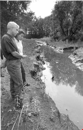
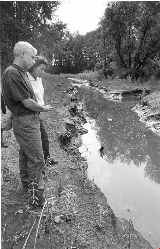
Kevin Conlin with Susan Haid
https://search.heritageburnaby.ca/link/archivedescription78559
- Repository
- City of Burnaby Archives
- Date
- October 1, 1995
- Collection/Fonds
- Burnaby NewsLeader photograph collection
- Description Level
- Item
- Physical Description
- 1 photograph : b&w ; 22.5 x 14.5 cm
- Scope and Content
- Photograph of Federal fisheries biologist Kevin Conlin with Burnaby environmental planner Susan Haid at salmon rearing area in Big Bend.
- Repository
- City of Burnaby Archives
- Date
- October 1, 1995
- Collection/Fonds
- Burnaby NewsLeader photograph collection
- Physical Description
- 1 photograph : b&w ; 22.5 x 14.5 cm
- Description Level
- Item
- Record No.
- 535-0003
- Access Restriction
- No restrictions
- Reproduction Restriction
- No reproduction permitted
- Accession Number
- 2012-11
- Scope and Content
- Photograph of Federal fisheries biologist Kevin Conlin with Burnaby environmental planner Susan Haid at salmon rearing area in Big Bend.
- Subjects
- Geographic Features - Creeks
- Names
- Conlin, Kevin
- Haid, Susan
- Media Type
- Photograph
- Photographer
- Ray, Steve
- Notes
- Title based on contents of photograph
- Note in black ink on recto of photograph reads: "Crop 65% / Bby pg 1 / Crop from top / Bby Steve Ray 2365C / 10/01 Bby/NW pg 9 - 104%"
- Trim marks and/or reproduction instructions on recto (scan is cropped)
- Historic Neighbourhood
- Fraser Arm (Historic Neighbourhood)
- Planning Study Area
- Big Bend Area
Images
![Mark Angelo in Deer Lake Brook, [2002] thumbnail](/media/hpo/_Data/_Archives_Images/_Unrestricted/535/535-2603.jpg?width=280)
Mark Angelo in Deer Lake Brook
https://search.heritageburnaby.ca/link/archivedescription97075
- Repository
- City of Burnaby Archives
- Date
- [2002]
- Collection/Fonds
- Burnaby NewsLeader photograph collection
- Description Level
- Item
- Physical Description
- 1 photograph (tiff) : col.
- Scope and Content
- Photograph of conservationist Mark Angelo standing in Deer Lake Brook.
- Repository
- City of Burnaby Archives
- Date
- [2002]
- Collection/Fonds
- Burnaby NewsLeader photograph collection
- Physical Description
- 1 photograph (tiff) : col.
- Description Level
- Item
- Record No.
- 535-2603
- Access Restriction
- No restrictions
- Reproduction Restriction
- No restrictions
- Accession Number
- 2018-12
- Scope and Content
- Photograph of conservationist Mark Angelo standing in Deer Lake Brook.
- Subjects
- Environmental Issues - Environmental Protection
- Environmental Issues
- Geographic Features - Streams
- Geographic Features - Creeks
- Names
- Angelo, Mark
- Media Type
- Photograph
- Photographer
- Ray, Steve
- Notes
- Title based on caption
- Collected by editorial for use in a July 2002 issue of the Burnaby NewsLeader
- Caption from metadata: "Mark Angelo in Deer Lake Brook, one of the streams that may be affected by the Federal Government cuts to community stream keepers."
- Geographic Access
- Deer Lake Brook
- Historic Neighbourhood
- Burnaby Lake (Historic Neighbourhood)
- Planning Study Area
- Morley-Buckingham Area
Images
![Mark Angelo in Deer Lake Brook, [2002] thumbnail](/media/hpo/_Data/_Archives_Images/_Unrestricted/535/535-2603.jpg)