Narrow Results By
Subject
- Advertising Medium - Signs and Signboards 6
- Aerial Photographs 4
- Agriculture - Farms 1
- Agriculture - Poultry 3
- Animals - Cows 1
- Animals - Poultry 3
- Buildings 1
- Buildings - Agricultural 3
- Buildings - Civic - Hospitals 1
- Buildings - Commercial 7
- Buildings - Commercial - Drugstores 3
- Buildings - Commercial - Grocery Stores 3
Campend
https://search.heritageburnaby.ca/link/archivedescription35144
- Repository
- City of Burnaby Archives
- Date
- 1938 (date of original), copied 1986
- Collection/Fonds
- Burnaby Historical Society fonds
- Description Level
- Item
- Physical Description
- 1 photograph : b&w ; 12.7 x 17.8 cm print
- Scope and Content
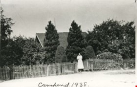
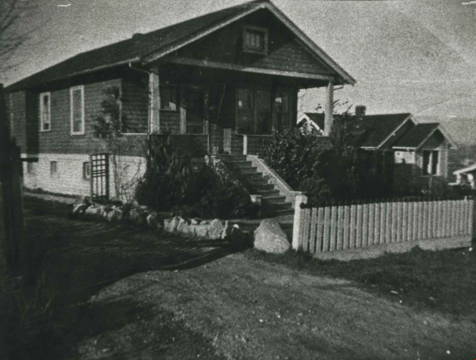
- Photograph of "Campend," the Shankie family home. Janet Shankie is standing in the gateway. The house was formerly numbered 3718 Barker Avenue and later renumbered 5155 Barker Avenue. An annotation at the bottom front of the photograph reads, "Campend 1938."
- Repository
- City of Burnaby Archives
- Date
- 1938 (date of original), copied 1986
- Collection/Fonds
- Burnaby Historical Society fonds
- Subseries
- Pioneer Tales subseries
- Physical Description
- 1 photograph : b&w ; 12.7 x 17.8 cm print
- Description Level
- Item
- Record No.
- 204-001
- Access Restriction
- No restrictions
- Reproduction Restriction
- No known restrictions
- Accession Number
- BHS1988-03
- Scope and Content
- Photograph of "Campend," the Shankie family home. Janet Shankie is standing in the gateway. The house was formerly numbered 3718 Barker Avenue and later renumbered 5155 Barker Avenue. An annotation at the bottom front of the photograph reads, "Campend 1938."
- Subjects
- Buildings - Residential - Houses
- Names
- Bower, Janet Shankie
- Media Type
- Photograph
- Notes
- Title based on caption on photograph
- Geographic Access
- Barker Avenue
- Street Address
- 5155 Barker Avenue
- Historic Neighbourhood
- Central Park (Historic Neighbourhood)
- Planning Study Area
- Garden Village Area
Images


Cash till line up
https://search.heritageburnaby.ca/link/archivedescription95107
- Repository
- City of Burnaby Archives
- Date
- April 27, 2020
- Collection/Fonds
- Burnaby Photographic Society fonds
- Description Level
- Item
- Physical Description
- 1 photograph (tiff)
- Scope and Content
- Photograph of shoppers in the checkout lines at Save-On-Foods grocery store at the Old Orchard Shopping Centre. On the floor are red decals indicating where shoppers should stand to maintain distance from one another. The decals read: "Allow 2M between shoppers".
- Repository
- City of Burnaby Archives
- Date
- April 27, 2020
- Collection/Fonds
- Burnaby Photographic Society fonds
- Physical Description
- 1 photograph (tiff)
- Description Level
- Item
- Record No.
- 623-025
- Access Restriction
- No restrictions
- Reproduction Restriction
- No restrictions
- Accession Number
- 2020-10
- Scope and Content
- Photograph of shoppers in the checkout lines at Save-On-Foods grocery store at the Old Orchard Shopping Centre. On the floor are red decals indicating where shoppers should stand to maintain distance from one another. The decals read: "Allow 2M between shoppers".
- Media Type
- Photograph
- Photographer
- Snowdon, Nick
- Notes
- Transcribed title
- Photographer's caption: "Physical distancing signs become common in most stores"
- Geographic Access
- Kingsway
- Street Address
- 4429 Kingsway
- Historic Neighbourhood
- Central Park (Historic Neighbourhood)
- Planning Study Area
- Garden Village Area
Images

![Cassidy Family on their Dairy Farm, [1912] (date of original), copied 1986 thumbnail](/media/hpo/_Data/_Archives_Images/_Unrestricted/204/204-074.jpg?width=280)
Cassidy Family on their Dairy Farm
https://search.heritageburnaby.ca/link/archivedescription35217
- Repository
- City of Burnaby Archives
- Date
- [1912] (date of original), copied 1986
- Collection/Fonds
- Burnaby Historical Society fonds
- Description Level
- Item
- Physical Description
- 1 photograph : b&w ; 12.7 x 20.3 cm print
- Scope and Content
- Photograph of the Cassidy family. Willie Cassidy (back), Mary Cassidy (left) and Mrs. Katherine Cassidy (foreground) are tending the dairy herd on the Cassidy farm at Darwin and Moscrop Streets. John Cassidy delivered milk.
- Repository
- City of Burnaby Archives
- Date
- [1912] (date of original), copied 1986
- Collection/Fonds
- Burnaby Historical Society fonds
- Subseries
- Pioneer Tales subseries
- Physical Description
- 1 photograph : b&w ; 12.7 x 20.3 cm print
- Description Level
- Item
- Record No.
- 204-074
- Access Restriction
- No restrictions
- Reproduction Restriction
- No known restrictions
- Accession Number
- BHS1988-03
- Scope and Content
- Photograph of the Cassidy family. Willie Cassidy (back), Mary Cassidy (left) and Mrs. Katherine Cassidy (foreground) are tending the dairy herd on the Cassidy farm at Darwin and Moscrop Streets. John Cassidy delivered milk.
- Subjects
- Animals - Cows
- Agriculture - Farms
- Media Type
- Photograph
- Notes
- Title based on contents of photograph
- Geographic Access
- Darwin Avenue
- Moscrop Street
- Historic Neighbourhood
- Central Park (Historic Neighbourhood)
- Planning Study Area
- Garden Village Area
Images
![Cassidy Family on their Dairy Farm, [1912] (date of original), copied 1986 thumbnail](/media/hpo/_Data/_Archives_Images/_Unrestricted/204/204-074.jpg)
![Central Park, [1921] thumbnail](/media/hpo/_Data/_Archives_Images/_Unrestricted/513/521-031.jpg?width=280)
Central Park
https://search.heritageburnaby.ca/link/archivedescription65799
- Repository
- City of Burnaby Archives
- Date
- [1921]
- Collection/Fonds
- Field family fonds
- Description Level
- Item
- Physical Description
- 1 photograph (tiff) ; 600 ppi
- Scope and Content
- Photograph of for Model-T Fords driving along Kingsway at Central Park. St. John Divine Church is visible on the right.
- Repository
- City of Burnaby Archives
- Date
- [1921]
- Collection/Fonds
- Field family fonds
- Physical Description
- 1 photograph (tiff) ; 600 ppi
- Material Details
- Item is a scan of a sepia photograph that is housed in a photographic album
- Description Level
- Item
- Record No.
- 521-031
- Access Restriction
- No restrictions
- Reproduction Restriction
- No known restrictions
- Accession Number
- 2010-14
- Scope and Content
- Photograph of for Model-T Fords driving along Kingsway at Central Park. St. John Divine Church is visible on the right.
- Subjects
- Transportation - Automobiles
- Media Type
- Photograph
- Notes
- Continuation of title: "Vancouver BC"
- Geographic Access
- Central Park
- Kingsway
- Street Address
- 3891 Kingsway
- Historic Neighbourhood
- Central Park (Historic Neighbourhood)
- Planning Study Area
- Garden Village Area
Images
![Central Park, [1921] thumbnail](/media/hpo/_Data/_Archives_Images/_Unrestricted/513/521-031.jpg)

Central Park Pharmacy
https://search.heritageburnaby.ca/link/archivedescription35024
- Repository
- City of Burnaby Archives
- Date
- July 1986
- Collection/Fonds
- Burnaby Historical Society fonds
- Description Level
- Item
- Physical Description
- 1 photograph : b&w ; 8.8 x 12.5 cm
- Scope and Content
- Photograph of the exterior of the Central Park Pharmacy and Post Office, 3967 Kingsway at Jersey Avenue. Signs read, "Central Park Pharmacy," "Post Office," and "Drugs." A view east down Kingsway can be seen on the right side of the photo. There is an automobile parked on the street, a firehydra…
- Repository
- City of Burnaby Archives
- Date
- July 1986
- Collection/Fonds
- Burnaby Historical Society fonds
- Subseries
- Evelyn Salisbury subseries
- Physical Description
- 1 photograph : b&w ; 8.8 x 12.5 cm
- Description Level
- Item
- Record No.
- 177-001
- Access Restriction
- No restrictions
- Reproduction Restriction
- Reproduce for fair dealing purposes only
- Accession Number
- BHS1986-25
- Scope and Content
- Photograph of the exterior of the Central Park Pharmacy and Post Office, 3967 Kingsway at Jersey Avenue. Signs read, "Central Park Pharmacy," "Post Office," and "Drugs." A view east down Kingsway can be seen on the right side of the photo. There is an automobile parked on the street, a firehydrant in the left corner of the photo, and apartment buildings in the background.
- Subjects
- Buildings - Commercial - Drugstores
- Names
- Central Park Pharmacy
- Media Type
- Photograph
- Notes
- Title based on contents of photograph
- Geographic Access
- Kingsway
- Jersey Avenue
- Street Address
- 3967 Kingsway
- Historic Neighbourhood
- Central Park (Historic Neighbourhood)
- Planning Study Area
- Garden Village Area
Images


Central Park Pharmacy
https://search.heritageburnaby.ca/link/archivedescription35025
- Repository
- City of Burnaby Archives
- Date
- July 1986
- Collection/Fonds
- Burnaby Historical Society fonds
- Description Level
- Item
- Physical Description
- 1 photograph : b&w ; 8.8 x 12.5 cm
- Scope and Content
- Photograph of the Central Park Pharmacy and Post Office, 3967 Kingsway at Jersey Avenue. A view north up Jersey Avenue can be seen at the left side of the photograph, and Kingsway can be seen at the front and right side of the photo. Signs read, "Central Park Pharmacy," "Drugs," and "Central Park…
- Repository
- City of Burnaby Archives
- Date
- July 1986
- Collection/Fonds
- Burnaby Historical Society fonds
- Subseries
- Evelyn Salisbury subseries
- Physical Description
- 1 photograph : b&w ; 8.8 x 12.5 cm
- Description Level
- Item
- Record No.
- 177-002
- Access Restriction
- No restrictions
- Reproduction Restriction
- Reproduce for fair dealing purposes only
- Accession Number
- BHS1986-25
- Scope and Content
- Photograph of the Central Park Pharmacy and Post Office, 3967 Kingsway at Jersey Avenue. A view north up Jersey Avenue can be seen at the left side of the photograph, and Kingsway can be seen at the front and right side of the photo. Signs read, "Central Park Pharmacy," "Drugs," and "Central Park." Automobiles and a truck are parked on the street. The north shore mountains can be seen in the background.
- Subjects
- Buildings - Commercial - Drugstores
- Names
- Central Park Pharmacy
- Media Type
- Photograph
- Notes
- Title based on contents of photograph
- Geographic Access
- Kingsway
- Jersey Avenue
- Street Address
- 3967 Kingsway
- Historic Neighbourhood
- Central Park (Historic Neighbourhood)
- Planning Study Area
- Garden Village Area
Images


Central Park Pharmacy
https://search.heritageburnaby.ca/link/archivedescription35026
- Repository
- City of Burnaby Archives
- Date
- July 1986
- Collection/Fonds
- Burnaby Historical Society fonds
- Description Level
- Item
- Physical Description
- 1 photograph : b&w ; 12.5 x 8.8 cm
- Scope and Content
- Photograph of the Central Park Pharmacy and Post Office, 3967 Kingsway at Jersey Avenue, with Mr. Chan, the pharmacist, standing outside. Some of the signs on the store read, "Central Park Pharmacy," "Post Office," "Drugs," "Visa," and "On Sale Here." A view east down Kingsway can be seen on the …
- Repository
- City of Burnaby Archives
- Date
- July 1986
- Collection/Fonds
- Burnaby Historical Society fonds
- Subseries
- Evelyn Salisbury subseries
- Physical Description
- 1 photograph : b&w ; 12.5 x 8.8 cm
- Description Level
- Item
- Record No.
- 177-003
- Access Restriction
- No restrictions
- Reproduction Restriction
- Reproduce for fair dealing purposes only
- Accession Number
- BHS1986-25
- Scope and Content
- Photograph of the Central Park Pharmacy and Post Office, 3967 Kingsway at Jersey Avenue, with Mr. Chan, the pharmacist, standing outside. Some of the signs on the store read, "Central Park Pharmacy," "Post Office," "Drugs," "Visa," and "On Sale Here." A view east down Kingsway can be seen on the right side of the photograph. Cars are visible on the street. A sign further down Kingsway reads, "TV: Tele-Peter." The street sign reads, "Jersey Ave 5600."
- Names
- Central Park Pharmacy
- Media Type
- Photograph
- Notes
- Title based on contents of photograph
- Geographic Access
- Kingsway
- Jersey Avenue
- Street Address
- 3967 Kingsway
- Historic Neighbourhood
- Central Park (Historic Neighbourhood)
- Planning Study Area
- Garden Village Area
Images


Central Park Place
https://search.heritageburnaby.ca/link/archivedescription79025
- Repository
- City of Burnaby Archives
- Date
- September 27, 1976
- Collection/Fonds
- Burnaby Public Library Contemporary Visual Archive Project
- Description Level
- Item
- Physical Description
- 1 photograph : b&w ; 11 x 16 cm mounted on cardboard
- Scope and Content
- Photograph shows an aerial view of one of the two high-rise apartments of Central Park Place. This building, located at 4160 Sardis Street, was built in 1975 by Narod Developments.
- Repository
- City of Burnaby Archives
- Date
- September 27, 1976
- Collection/Fonds
- Burnaby Public Library Contemporary Visual Archive Project
- Physical Description
- 1 photograph : b&w ; 11 x 16 cm mounted on cardboard
- Description Level
- Item
- Record No.
- 556-098
- Access Restriction
- No restrictions
- Reproduction Restriction
- Reproduce for fair dealing purposes only
- Accession Number
- 2013-13
- Scope and Content
- Photograph shows an aerial view of one of the two high-rise apartments of Central Park Place. This building, located at 4160 Sardis Street, was built in 1975 by Narod Developments.
- Subjects
- Buildings - Residential - Apartments
- Media Type
- Photograph
- Photographer
- Norton, Paul
- Notes
- Scope note taken directly from BPL photograph description.
- 1 b&w copy negative : 10 x 12.5 cm accompanying
- Geographic Access
- Sardis Street
- Street Address
- 4160 Sardis Street
- Historic Neighbourhood
- Central Park (Historic Neighbourhood)
- Planning Study Area
- Garden Village Area
Images


Central Park Presbyterian Church
https://search.heritageburnaby.ca/link/archivedescription36672
- Repository
- City of Burnaby Archives
- Date
- 1912 (date of original), copied 1992
- Collection/Fonds
- Burnaby Historical Society fonds
- Description Level
- Item
- Physical Description
- 1 photograph : b&w ; 10.1 x 14.9 cm print
- Scope and Content
- Photograph of Central Park Presbyterian Church and the surrounding area. The church was located on Westminster Road (later Kingsway) across from Central Park.
- Repository
- City of Burnaby Archives
- Date
- 1912 (date of original), copied 1992
- Collection/Fonds
- Burnaby Historical Society fonds
- Subseries
- Burnaby Centennial Anthology subseries
- Physical Description
- 1 photograph : b&w ; 10.1 x 14.9 cm print
- Description Level
- Item
- Record No.
- 315-027
- Access Restriction
- No restrictions
- Reproduction Restriction
- No known restrictions
- Accession Number
- BHS1994-04
- Scope and Content
- Photograph of Central Park Presbyterian Church and the surrounding area. The church was located on Westminster Road (later Kingsway) across from Central Park.
- Media Type
- Photograph
- Geographic Access
- Westminster Avenue
- Kingsway
- Street Address
- 3777 Kingsway
- Historic Neighbourhood
- Central Park (Historic Neighbourhood)
- Planning Study Area
- Garden Village Area
Images


Central Park Presbyterian Church
https://search.heritageburnaby.ca/link/archivedescription36673
- Repository
- City of Burnaby Archives
- Date
- 1896 (date of original), copied 1992
- Collection/Fonds
- Burnaby Historical Society fonds
- Description Level
- Item
- Physical Description
- 1 photograph : b&w ; 10.1 x 14.9 cm print
- Scope and Content
- Photograph of the exterior of Central Park Presbyterian Church. Typed note at the bottom of the photograph reads, "The Original Presbyterian Church on Westminster Road at Central Park as in approx. 1896. Burned down and rebuilt. Mrs. P. Oben."
- Repository
- City of Burnaby Archives
- Date
- 1896 (date of original), copied 1992
- Collection/Fonds
- Burnaby Historical Society fonds
- Subseries
- Burnaby Centennial Anthology subseries
- Physical Description
- 1 photograph : b&w ; 10.1 x 14.9 cm print
- Description Level
- Item
- Record No.
- 315-028
- Access Restriction
- No restrictions
- Reproduction Restriction
- No known restrictions
- Accession Number
- BHS1994-04
- Scope and Content
- Photograph of the exterior of Central Park Presbyterian Church. Typed note at the bottom of the photograph reads, "The Original Presbyterian Church on Westminster Road at Central Park as in approx. 1896. Burned down and rebuilt. Mrs. P. Oben."
- Subjects
- Buildings - Religious - Churches
- Media Type
- Photograph
- Notes
- Title based on contents of photograph
- Geographic Access
- Westminster Avenue
- Kingsway
- Street Address
- 3777 Kingsway
- Historic Neighbourhood
- Central Park (Historic Neighbourhood)
- Planning Study Area
- Garden Village Area
Images


Chaffey-Burke Elementary School
https://search.heritageburnaby.ca/link/archivedescription62691
- Repository
- City of Burnaby Archives
- Date
- September 4, 2009
- Collection/Fonds
- Community Heritage Commission Special Projects fonds
- Description Level
- Item
- Physical Description
- 1 photograph (tiff) : col. ; 600 ppi
- Scope and Content
- Photograph of Chaffey-Burke Elementary School.
- Repository
- City of Burnaby Archives
- Date
- September 4, 2009
- Collection/Fonds
- Community Heritage Commission Special Projects fonds
- Physical Description
- 1 photograph (tiff) : col. ; 600 ppi
- Description Level
- Item
- Record No.
- 503-026
- Access Restriction
- No restrictions
- Reproduction Restriction
- No restrictions
- Accession Number
- 2009-10
- Scope and Content
- Photograph of Chaffey-Burke Elementary School.
- Subjects
- Buildings - Schools
- Media Type
- Photograph
- Photographer
- Pasch, Rebecca
- Notes
- Title based on contents of photograph
- Geographic Access
- Sardis Street
- Street Address
- 4404 Sardis Street
- Historic Neighbourhood
- Central Park (Historic Neighbourhood)
- Planning Study Area
- Garden Village Area
Images

![Chaffey-Burke School Sports Day, [between 1970 and 1974] (date of original), copied 1991 thumbnail](/media/hpo/_Data/_Archives_Images/_Unrestricted/370/370-159.jpg?width=280)
Chaffey-Burke School Sports Day
https://search.heritageburnaby.ca/link/archivedescription37571
- Repository
- City of Burnaby Archives
- Date
- [between 1970 and 1974] (date of original), copied 1991
- Collection/Fonds
- Burnaby Historical Society fonds
- Description Level
- Item
- Physical Description
- 1 photograph : b&w ; 4.0 x 4.0 cm print on contact sheet 20.2 x 25.3 cm
- Scope and Content
- Photograph of Sports Day at Chaffey-Burke School. Children are running on a field.
- Repository
- City of Burnaby Archives
- Date
- [between 1970 and 1974] (date of original), copied 1991
- Collection/Fonds
- Burnaby Historical Society fonds
- Subseries
- Burnaby Image Bank subseries
- Physical Description
- 1 photograph : b&w ; 4.0 x 4.0 cm print on contact sheet 20.2 x 25.3 cm
- Description Level
- Item
- Record No.
- 370-159
- Access Restriction
- No restrictions
- Reproduction Restriction
- May be restricted by third party rights
- Accession Number
- BHS1999-03
- Scope and Content
- Photograph of Sports Day at Chaffey-Burke School. Children are running on a field.
- Media Type
- Photograph
- Notes
- Title based on contents of photograph
- 1 b&w copy negative accompanying
- Copied from a col. photograph
- Geographic Access
- Sardis Street
- Willingdon Avenue
- Historic Neighbourhood
- Central Park (Historic Neighbourhood)
- Planning Study Area
- Garden Village Area
Images
![Chaffey-Burke School Sports Day, [between 1970 and 1974] (date of original), copied 1991 thumbnail](/media/hpo/_Data/_Archives_Images/_Unrestricted/370/370-159.jpg)
![Chaffey-Burke School Sports Day, [between 1970 and 1974] (date of original), copied 1991 thumbnail](/media/hpo/_Data/_Archives_Images/_Unrestricted/370/370-160.jpg?width=280)
Chaffey-Burke School Sports Day
https://search.heritageburnaby.ca/link/archivedescription37572
- Repository
- City of Burnaby Archives
- Date
- [between 1970 and 1974] (date of original), copied 1991
- Collection/Fonds
- Burnaby Historical Society fonds
- Description Level
- Item
- Physical Description
- 1 photograph : b&w ; 4.0 x 4.0 cm print on contact sheet 20.2 x 25.3 cm
- Scope and Content
- Photograph of Sports Day at Chaffey-Burke School. Children are participating in activities on a field while adults look on. Houses are visible in the background.
- Repository
- City of Burnaby Archives
- Date
- [between 1970 and 1974] (date of original), copied 1991
- Collection/Fonds
- Burnaby Historical Society fonds
- Subseries
- Burnaby Image Bank subseries
- Physical Description
- 1 photograph : b&w ; 4.0 x 4.0 cm print on contact sheet 20.2 x 25.3 cm
- Description Level
- Item
- Record No.
- 370-160
- Access Restriction
- No restrictions
- Reproduction Restriction
- May be restricted by third party rights
- Accession Number
- BHS1999-03
- Scope and Content
- Photograph of Sports Day at Chaffey-Burke School. Children are participating in activities on a field while adults look on. Houses are visible in the background.
- Media Type
- Photograph
- Notes
- Title based on contents of photograph
- 1 b&w copy negative accompanying
- Copied from a col. photograph
- Geographic Access
- Sardis Street
- Willingdon Avenue
- Historic Neighbourhood
- Central Park (Historic Neighbourhood)
- Planning Study Area
- Garden Village Area
Images
![Chaffey-Burke School Sports Day, [between 1970 and 1974] (date of original), copied 1991 thumbnail](/media/hpo/_Data/_Archives_Images/_Unrestricted/370/370-160.jpg)
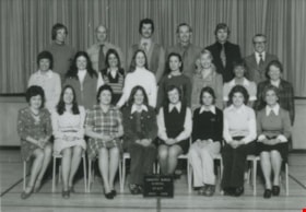
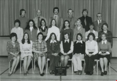
Chaffey-Burke School Staff
https://search.heritageburnaby.ca/link/archivedescription37593
- Repository
- City of Burnaby Archives
- Date
- 1974 (date of original), copied 1991
- Collection/Fonds
- Burnaby Historical Society fonds
- Description Level
- Item
- Physical Description
- 1 photograph : b&w ; 3.6 x 5.2 cm print on contact sheet 20.2 x 25.3 cm
- Scope and Content
- Photograph of staff at Chaffey-Burke School.
- Repository
- City of Burnaby Archives
- Date
- 1974 (date of original), copied 1991
- Collection/Fonds
- Burnaby Historical Society fonds
- Subseries
- Burnaby Image Bank subseries
- Physical Description
- 1 photograph : b&w ; 3.6 x 5.2 cm print on contact sheet 20.2 x 25.3 cm
- Description Level
- Item
- Record No.
- 370-181
- Access Restriction
- No restrictions
- Reproduction Restriction
- No restrictions
- Accession Number
- BHS1999-03
- Scope and Content
- Photograph of staff at Chaffey-Burke School.
- Subjects
- Occupations - Teachers
- Media Type
- Photograph
- Notes
- Title based on contents of photograph
- 1 b&w copy negative accompanying
- Copied from a col. photograph
- Negative has a pink cast
- Geographic Access
- Sardis Street
- Willingdon Avenue
- Historic Neighbourhood
- Central Park (Historic Neighbourhood)
- Planning Study Area
- Garden Village Area
Images
Engelland family home
https://search.heritageburnaby.ca/link/archivedescription35757
- Repository
- City of Burnaby Archives
- Date
- 1920 (date of original), copied 1986
- Collection/Fonds
- Burnaby Historical Society fonds
- Description Level
- Item
- Physical Description
- 1 photograph : b&w ; 12.7 x 17.8 cm print
- Scope and Content
- Photograph of the Engelland family home, 3706 Patterson Avenue (later renumbered 5587 Patterson Avenue). The family lived here from 1926-1953. Five children were born here, and they all attended Inman School.
- Repository
- City of Burnaby Archives
- Date
- 1920 (date of original), copied 1986
- Collection/Fonds
- Burnaby Historical Society fonds
- Subseries
- Pioneer Tales subseries
- Physical Description
- 1 photograph : b&w ; 12.7 x 17.8 cm print
- Description Level
- Item
- Record No.
- 204-615
- Access Restriction
- No restrictions
- Reproduction Restriction
- No known restrictions
- Accession Number
- BHS1988-03
- Scope and Content
- Photograph of the Engelland family home, 3706 Patterson Avenue (later renumbered 5587 Patterson Avenue). The family lived here from 1926-1953. Five children were born here, and they all attended Inman School.
- Subjects
- Buildings - Residential - Houses
- Media Type
- Photograph
- Notes
- Title based on contents of photograph
- Geographic Access
- Patterson Avenue
- Street Address
- 5587 Patterson Avenue
- Historic Neighbourhood
- Central Park (Historic Neighbourhood)
- Planning Study Area
- Garden Village Area
Images

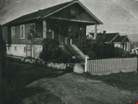
Farrington Chicken Ranch
https://search.heritageburnaby.ca/link/archivedescription35226
- Repository
- City of Burnaby Archives
- Date
- 1920 (date of original), copied 1986
- Collection/Fonds
- Burnaby Historical Society fonds
- Description Level
- Item
- Physical Description
- 1 photograph : b&w ; 12.7 x 17.8 cm print
- Scope and Content
- Photograph of the Farrington brothers' chicken ranch near Central Park at 3907 Chesham Avenue (later renumbered 5384 Chesham Avenue). Brothers Thomas Farrington and Richard Farrington founded Wheat Sheaf Poultry Ranch in 1919. The laying house is at the left, and the family home is at the right.
- Repository
- City of Burnaby Archives
- Date
- 1920 (date of original), copied 1986
- Collection/Fonds
- Burnaby Historical Society fonds
- Subseries
- Pioneer Tales subseries
- Physical Description
- 1 photograph : b&w ; 12.7 x 17.8 cm print
- Description Level
- Item
- Record No.
- 204-083
- Access Restriction
- No restrictions
- Reproduction Restriction
- No known restrictions
- Accession Number
- BHS1988-03
- Scope and Content
- Photograph of the Farrington brothers' chicken ranch near Central Park at 3907 Chesham Avenue (later renumbered 5384 Chesham Avenue). Brothers Thomas Farrington and Richard Farrington founded Wheat Sheaf Poultry Ranch in 1919. The laying house is at the left, and the family home is at the right.
- Subjects
- Buildings - Agricultural
- Animals - Poultry
- Agriculture - Poultry
- Buildings - Residential - Houses
- Media Type
- Photograph
- Notes
- Title based on contents of photograph
- Geographic Access
- Chesham Avenue
- Street Address
- 5384 Chesham Avenue
- Historic Neighbourhood
- Central Park (Historic Neighbourhood)
- Planning Study Area
- Garden Village Area
Images


Farrington Laying House
https://search.heritageburnaby.ca/link/archivedescription35227
- Repository
- City of Burnaby Archives
- Date
- 1920 (date of original), copied 1986
- Collection/Fonds
- Burnaby Historical Society fonds
- Description Level
- Item
- Physical Description
- 1 photograph : b&w ; 12.7 x 17.8 cm print
- Scope and Content
- Photograph of Farrington brothers' chicken laying house. Brothers Thomas Farrington and Richard Farrington founded Wheat Sheaf Poultry Ranch in 1919. It was located at 3907 Chesham Avenue (later renumbered 5384 Chesham Avenue).
- Repository
- City of Burnaby Archives
- Date
- 1920 (date of original), copied 1986
- Collection/Fonds
- Burnaby Historical Society fonds
- Subseries
- Pioneer Tales subseries
- Physical Description
- 1 photograph : b&w ; 12.7 x 17.8 cm print
- Description Level
- Item
- Record No.
- 204-084
- Access Restriction
- No restrictions
- Reproduction Restriction
- No known restrictions
- Accession Number
- BHS1988-03
- Scope and Content
- Photograph of Farrington brothers' chicken laying house. Brothers Thomas Farrington and Richard Farrington founded Wheat Sheaf Poultry Ranch in 1919. It was located at 3907 Chesham Avenue (later renumbered 5384 Chesham Avenue).
- Media Type
- Photograph
- Notes
- Title based on contents of photograph
- Geographic Access
- Chesham Avenue
- Street Address
- 5384 Chesham Avenue
- Historic Neighbourhood
- Central Park (Historic Neighbourhood)
- Planning Study Area
- Garden Village Area
Images

Fire insurance plans - Greater Vancouver - Volume XVII - Municipality of Burnaby
https://search.heritageburnaby.ca/link/museumdescription17797
- Repository
- Burnaby Village Museum
- Date
- 1927-1950
- Collection/Fonds
- Burnaby Village Museum Map collection
- Description Level
- Item
- Physical Description
- 4 plans on 4 sheets : col. lithographic prints
- Scope and Content
- Item consists of fire insurance plans titled "Greater Vancouver / Volume XVII / Municipality / of Burnaby" surveyed May 1927, revised in October 1940 and September 1950. Includes a two page key plan (E and F) and two associated plans numbered 1729 and 1738 (located within District Lot 35).
- Repository
- Burnaby Village Museum
- Collection/Fonds
- Burnaby Village Museum Map collection
- Description Level
- Item
- Physical Description
- 4 plans on 4 sheets : col. lithographic prints
- Scope and Content
- Item consists of fire insurance plans titled "Greater Vancouver / Volume XVII / Municipality / of Burnaby" surveyed May 1927, revised in October 1940 and September 1950. Includes a two page key plan (E and F) and two associated plans numbered 1729 and 1738 (located within District Lot 35).
- Publisher
- Plan Department of Fire Branch of British Columbia Underwriters' Association
- Accession Code
- BV987.1.70
- Access Restriction
- No restrictions
- Reproduction Restriction
- May be restricted by third party rights
- Date
- 1927-1950
- Media Type
- Cartographic Material
- Historic Neighbourhood
- Central Park (Historic Neighbourhood)
- Planning Study Area
- Garden Village Area
- Scan Resolution
- 400
- Scan Date
- 2021-11-17
- Notes
- Title based on contents of item
- These plans were removed from a bound book with labels on cover page reading: "Plan No. 90 / THIS INSURANCE PLAN / of / Vancouver VOLUME "8" / IN THE PROPERTY OF THE / British Columbia Insurance Underwriter's Association / Vancouver B.C. / AND IS LOANED / MELVILLE F. THOMSON CO. .../ Date May 26th, 1934"; / "Plan No. 74 / THIS INSURANCE PLAN / OF / VANCOUVER VOLUME "9"" / Plan No. 11 / THIS INSURANCE PLAN / OF / BURNABY VOLUMES 15-19" / "THIS PLAN IS THE PROPERTY OF / THE / BRITISH LAW INSURANCE COMPANY / LIMITED"
- Contact Burnaby Village Museum to view associated fire insurance plans XVIII

Gilpin Crescent
https://search.heritageburnaby.ca/link/archivedescription79968
- Repository
- City of Burnaby Archives
- Date
- September 16, 1976
- Collection/Fonds
- Burnaby Public Library Contemporary Visual Archive Project
- Description Level
- Item
- Physical Description
- 1 photograph : b&w ; 11 x 16 cm mounted on cardboard
- Scope and Content
- Photograph shows a view looking north up Gilpin Crescent from Price Crescent with Burnaby General Hospital in the background.
- Repository
- City of Burnaby Archives
- Date
- September 16, 1976
- Collection/Fonds
- Burnaby Public Library Contemporary Visual Archive Project
- Physical Description
- 1 photograph : b&w ; 11 x 16 cm mounted on cardboard
- Description Level
- Item
- Record No.
- 556-531
- Access Restriction
- No restrictions
- Reproduction Restriction
- Reproduce for fair dealing purposes only
- Accession Number
- 2013-13
- Scope and Content
- Photograph shows a view looking north up Gilpin Crescent from Price Crescent with Burnaby General Hospital in the background.
- Media Type
- Photograph
- Photographer
- Norton, Paul
- Notes
- Scope note taken directly from BPL photograph description.
- 1 b&w copy negative : 10 x 12.5 cm accompanying
- Geographic Access
- Gilpin Crescent
- Price Crescent
- Historic Neighbourhood
- Central Park (Historic Neighbourhood)
- Planning Study Area
- Garden Village Area
Images

Graduation records
https://search.heritageburnaby.ca/link/archivedescription82734
- Repository
- City of Burnaby Archives
- Date
- [1930-1941]
- Collection/Fonds
- Hazel Simnett collection
- Description Level
- File
- Physical Description
- 1 folder of textual records
- Scope and Content
- File consists of two envelopes and one dictionary. One envelope is empty and is addressed to: "To Whom it May Concern" and is from: "Hugh M. Fraser High School / 2350 Kingsway / New Westminster, BC". It most likely contained the reference letter from May 12, 1941 written by the principal of Hugh M.…
- Repository
- City of Burnaby Archives
- Date
- [1930-1941]
- Collection/Fonds
- Hazel Simnett collection
- Physical Description
- 1 folder of textual records
- Description Level
- File
- Record No.
- MSS167-013
- Accession Number
- 2013-22
- Scope and Content
- File consists of two envelopes and one dictionary. One envelope is empty and is addressed to: "To Whom it May Concern" and is from: "Hugh M. Fraser High School / 2350 Kingsway / New Westminster, BC". It most likely contained the reference letter from May 12, 1941 written by the principal of Hugh M. Fraser Senior and Junior High Schools. The second envelope is addressed to "Miss Hazel Simnett / 4019 Kingsway / New Westminster, BC" from the Department of Education in Victoria, BC. It contains the reference letter as discussed previously, a University Entrance Examination certificate, a High School Graduation certificate from Burnaby South High School, a Grade Twelve Examination Junior Matriculation certificate and a purple and gold ribbon. The dictionary is a Nelson's "Highroads" English Dictionary. Inside an inscription reads: "Hazel Simnett / 4019 Kingsway / Burnaby / BSHS / Hazel Simnett / Kingsway West School".
- Subjects
- Personal Symbols - Certificates
- Names
- Simnett, Hazel
- Media Type
- Textual Record
- Notes
- Title based on contents of file
- Simnett personal papers series
- Geographic Access
- Kingsway
- Historic Neighbourhood
- Central Park (Historic Neighbourhood)
- Planning Study Area
- Garden Village Area