Narrow Results By
Subject
- Agriculture - Farms 1
- Animals - Cows 1
- Buildings - Civic - Hospitals 1
- Buildings - Heritage 2
- Buildings - Industrial - Mills 2
- Buildings - Religious - Churches 6
- Buildings - Residential - Apartments 1
- Buildings - Residential - Houses 2
- Buildings - Schools 2
- Construction 2
- Documentary Artifacts - Postcards 1
- Geographic Features - Roads 2
Person / Organization
- Allard, Nancy Davis 1
- Barber, Olive Farrington 1
- British Columbia Electric Railway Company 1
- Burnaby Fire Department 1
- Cassidy, Katherine Burns 1
- Cassidy, Marjorie 1
- Cassidy, Willie 1
- Central Park Presbyterian Church 1
- Chaffey-Burke Elementary School 1
- Inman Avenue School 2
- Reilly, Mary Cassidy 1
- Royal Canadian Mounted Police 1
![Apartment building fire, [2005] thumbnail](/media/hpo/_Data/_Archives_Images/_Unrestricted/535/535-1865.jpg?width=280)
Apartment building fire
https://search.heritageburnaby.ca/link/archivedescription96168
- Repository
- City of Burnaby Archives
- Date
- [2005]
- Collection/Fonds
- Burnaby NewsLeader photograph collection
- Description Level
- Item
- Physical Description
- 1 photograph (tiff) : col.
- Scope and Content
- Photograph of a paramedic assisting a woman to leave an apartment building at Wilson and Grange Avenue after a fire. The apartment building and other emergency responders are visible in the background.
- Repository
- City of Burnaby Archives
- Date
- [2005]
- Collection/Fonds
- Burnaby NewsLeader photograph collection
- Physical Description
- 1 photograph (tiff) : col.
- Description Level
- Item
- Record No.
- 535-1865
- Access Restriction
- No restrictions
- Reproduction Restriction
- No restrictions
- Accession Number
- 2018-12
- Scope and Content
- Photograph of a paramedic assisting a woman to leave an apartment building at Wilson and Grange Avenue after a fire. The apartment building and other emergency responders are visible in the background.
- Media Type
- Photograph
- Photographer
- Bartel, Mario
- Notes
- Title based on caption
- Collected by editorial for use in a January 2005 issue of the Burnaby NewsLeader
- Caption from metadata: "A paramedic helps Marg Wilson to one of two Translink busses brought in for residents of an apartment building at Wilson and Grange Ave. in Burnaby who were evacuated after a fire gutted a suite on the eighth floor on Wednesday."
- Geographic Access
- Wilson Avenue
- Grange Street
- Historic Neighbourhood
- Central Park (Historic Neighbourhood)
- Planning Study Area
- Garden Village Area
Images
![Apartment building fire, [2005] thumbnail](/media/hpo/_Data/_Archives_Images/_Unrestricted/535/535-1865.jpg)

Boundary Road and Park Avenue station
https://search.heritageburnaby.ca/link/archivedescription36670
- Repository
- City of Burnaby Archives
- Date
- 1912 (date of original), copied 1992
- Collection/Fonds
- Burnaby Historical Society fonds
- Description Level
- Item
- Physical Description
- 1 photograph : b&w ; 10.1 x 14.9 cm print
- Scope and Content
- Photograph of Boundary Road, Park Avenue Interurban station, and the surrounding area, looking north from Kingsway. The Coburn house, built in 1906, is at the top of the hill on the right, current address 5170 Boundary Road.
- Repository
- City of Burnaby Archives
- Date
- 1912 (date of original), copied 1992
- Collection/Fonds
- Burnaby Historical Society fonds
- Subseries
- Burnaby Centennial Anthology subseries
- Physical Description
- 1 photograph : b&w ; 10.1 x 14.9 cm print
- Description Level
- Item
- Record No.
- 315-025
- Access Restriction
- No restrictions
- Reproduction Restriction
- No known restrictions
- Accession Number
- BHS1994-04
- Scope and Content
- Photograph of Boundary Road, Park Avenue Interurban station, and the surrounding area, looking north from Kingsway. The Coburn house, built in 1906, is at the top of the hill on the right, current address 5170 Boundary Road.
- Media Type
- Photograph
- Notes
- Title based on contents of photograph
- Annotation at bottom of photograph reads; "Boundary Rd and Park Ave Station"
- Geographic Access
- Boundary Road
- Kingsway
- Historic Neighbourhood
- Central Park (Historic Neighbourhood)
- Planning Study Area
- Garden Village Area
Images

![Cassidy Family on their Dairy Farm, [1912] (date of original), copied 1986 thumbnail](/media/hpo/_Data/_Archives_Images/_Unrestricted/204/204-074.jpg?width=280)
Cassidy Family on their Dairy Farm
https://search.heritageburnaby.ca/link/archivedescription35217
- Repository
- City of Burnaby Archives
- Date
- [1912] (date of original), copied 1986
- Collection/Fonds
- Burnaby Historical Society fonds
- Description Level
- Item
- Physical Description
- 1 photograph : b&w ; 12.7 x 20.3 cm print
- Scope and Content
- Photograph of the Cassidy family. Willie Cassidy (back), Mary Cassidy (left) and Mrs. Katherine Cassidy (foreground) are tending the dairy herd on the Cassidy farm at Darwin and Moscrop Streets. John Cassidy delivered milk.
- Repository
- City of Burnaby Archives
- Date
- [1912] (date of original), copied 1986
- Collection/Fonds
- Burnaby Historical Society fonds
- Subseries
- Pioneer Tales subseries
- Physical Description
- 1 photograph : b&w ; 12.7 x 20.3 cm print
- Description Level
- Item
- Record No.
- 204-074
- Access Restriction
- No restrictions
- Reproduction Restriction
- No known restrictions
- Accession Number
- BHS1988-03
- Scope and Content
- Photograph of the Cassidy family. Willie Cassidy (back), Mary Cassidy (left) and Mrs. Katherine Cassidy (foreground) are tending the dairy herd on the Cassidy farm at Darwin and Moscrop Streets. John Cassidy delivered milk.
- Subjects
- Animals - Cows
- Agriculture - Farms
- Media Type
- Photograph
- Notes
- Title based on contents of photograph
- Geographic Access
- Darwin Avenue
- Moscrop Street
- Historic Neighbourhood
- Central Park (Historic Neighbourhood)
- Planning Study Area
- Garden Village Area
Images
![Cassidy Family on their Dairy Farm, [1912] (date of original), copied 1986 thumbnail](/media/hpo/_Data/_Archives_Images/_Unrestricted/204/204-074.jpg)

Central Park Presbyterian Church
https://search.heritageburnaby.ca/link/archivedescription36672
- Repository
- City of Burnaby Archives
- Date
- 1912 (date of original), copied 1992
- Collection/Fonds
- Burnaby Historical Society fonds
- Description Level
- Item
- Physical Description
- 1 photograph : b&w ; 10.1 x 14.9 cm print
- Scope and Content
- Photograph of Central Park Presbyterian Church and the surrounding area. The church was located on Westminster Road (later Kingsway) across from Central Park.
- Repository
- City of Burnaby Archives
- Date
- 1912 (date of original), copied 1992
- Collection/Fonds
- Burnaby Historical Society fonds
- Subseries
- Burnaby Centennial Anthology subseries
- Physical Description
- 1 photograph : b&w ; 10.1 x 14.9 cm print
- Description Level
- Item
- Record No.
- 315-027
- Access Restriction
- No restrictions
- Reproduction Restriction
- No known restrictions
- Accession Number
- BHS1994-04
- Scope and Content
- Photograph of Central Park Presbyterian Church and the surrounding area. The church was located on Westminster Road (later Kingsway) across from Central Park.
- Media Type
- Photograph
- Geographic Access
- Westminster Avenue
- Kingsway
- Street Address
- 3777 Kingsway
- Historic Neighbourhood
- Central Park (Historic Neighbourhood)
- Planning Study Area
- Garden Village Area
Images


Chaffey-Burke Elementary School
https://search.heritageburnaby.ca/link/archivedescription62691
- Repository
- City of Burnaby Archives
- Date
- September 4, 2009
- Collection/Fonds
- Community Heritage Commission Special Projects fonds
- Description Level
- Item
- Physical Description
- 1 photograph (tiff) : col. ; 600 ppi
- Scope and Content
- Photograph of Chaffey-Burke Elementary School.
- Repository
- City of Burnaby Archives
- Date
- September 4, 2009
- Collection/Fonds
- Community Heritage Commission Special Projects fonds
- Physical Description
- 1 photograph (tiff) : col. ; 600 ppi
- Description Level
- Item
- Record No.
- 503-026
- Access Restriction
- No restrictions
- Reproduction Restriction
- No restrictions
- Accession Number
- 2009-10
- Scope and Content
- Photograph of Chaffey-Burke Elementary School.
- Subjects
- Buildings - Schools
- Media Type
- Photograph
- Photographer
- Pasch, Rebecca
- Notes
- Title based on contents of photograph
- Geographic Access
- Sardis Street
- Street Address
- 4404 Sardis Street
- Historic Neighbourhood
- Central Park (Historic Neighbourhood)
- Planning Study Area
- Garden Village Area
Images

![Home of Richard and Clara Thorpe, [1911] thumbnail](/media/hpo/_Data/_BVM_Images/1990/199900610001.jpg?width=280)
Home of Richard and Clara Thorpe
https://search.heritageburnaby.ca/link/museumdescription1507
- Repository
- Burnaby Village Museum
- Date
- [1911]
- Collection/Fonds
- Burnaby Village Museum Photograph collection
- Description Level
- Item
- Physical Description
- 1 photograph : b&w ; 10x 14 cm, mounted on card 15 x 22.5 cm
- Scope and Content
- Photograph of the home of Richard and Clara Thorpe. Nancy Davis Allard is standing, holding baby Dorothy Thorp (later Spain) upright in a buggy at the foot of the stairs. Two unidentified woman are also visible sitting at the top of the stairs.
- Repository
- Burnaby Village Museum
- Collection/Fonds
- Burnaby Village Museum Photograph collection
- Description Level
- Item
- Physical Description
- 1 photograph : b&w ; 10x 14 cm, mounted on card 15 x 22.5 cm
- Scope and Content
- Photograph of the home of Richard and Clara Thorpe. Nancy Davis Allard is standing, holding baby Dorothy Thorp (later Spain) upright in a buggy at the foot of the stairs. Two unidentified woman are also visible sitting at the top of the stairs.
- Subjects
- Buildings - Residential - Houses
- Geographic Access
- Boundary Road
- Burke Street
- Accession Code
- BV999.61.1
- Access Restriction
- No restrictions
- Date
- [1911]
- Media Type
- Photograph
- Historic Neighbourhood
- Central Park (Historic Neighbourhood)
- Planning Study Area
- Garden Village Area
- Scan Resolution
- 600
- Scan Date
- 09-Jun-09
- Scale
- 100
- Notes
- Title based on contents of photograph
- Note in blue ink on verso of photograph reads: "Home of Richard and/ Clara Thorp - about 1911./ Built in 1907. Boundary/ & Burke St. - Burnaby/ I'm in the buggy, held upright by my/ dear friend Nance -"
Images
![Home of Richard and Clara Thorpe, [1911] thumbnail](/media/hpo/_Data/_BVM_Images/1990/199900610001.jpg)
![Hospital Employees Union demonstration, [2002] thumbnail](/media/hpo/_Data/_Archives_Images/_Unrestricted/535/535-3025.jpg?width=280)
Hospital Employees Union demonstration
https://search.heritageburnaby.ca/link/archivedescription97751
- Repository
- City of Burnaby Archives
- Date
- [2002]
- Collection/Fonds
- Burnaby NewsLeader photograph collection
- Description Level
- Item
- Physical Description
- 1 photograph (tiff) : col.
- Scope and Content
- Photograph of unidentified people gathered as part of a Hospital Employees Union demonstration to protest lay-offs of health care workers at Willingdon Park Hospital. The demonstrators are holding signs and waving to traffic.
- Repository
- City of Burnaby Archives
- Date
- [2002]
- Collection/Fonds
- Burnaby NewsLeader photograph collection
- Physical Description
- 1 photograph (tiff) : col.
- Description Level
- Item
- Record No.
- 535-3025
- Access Restriction
- No restrictions
- Reproduction Restriction
- No restrictions
- Accession Number
- 2018-12
- Scope and Content
- Photograph of unidentified people gathered as part of a Hospital Employees Union demonstration to protest lay-offs of health care workers at Willingdon Park Hospital. The demonstrators are holding signs and waving to traffic.
- Subjects
- Buildings - Civic - Hospitals
- Public Services - Health Services
- Protests and Demonstrations
- Organizations - Unions
- Media Type
- Photograph
- Photographer
- Bartel, Mario
- Notes
- Title based on caption
- Collected by editorial for use in a December 2002 issue of the Burnaby NewsLeader
- Caption from metadata: "Laid off health care workers at Willingdon Park Hospital rally to protest provincial government policies on contracting out. The union representing the workers says 18 housekeeping, laundry and dietary staff will be out of work by January 19."
- Geographic Access
- Grange Street
- Street Address
- 4435 Grange Street
- Historic Neighbourhood
- Central Park (Historic Neighbourhood)
- Planning Study Area
- Garden Village Area
Images
![Hospital Employees Union demonstration, [2002] thumbnail](/media/hpo/_Data/_Archives_Images/_Unrestricted/535/535-3025.jpg)
![House fire on Smith Avenue, [2001] thumbnail](/media/hpo/_Data/_Archives_Images/_Unrestricted/535/535-2254.jpg?width=280)
House fire on Smith Avenue
https://search.heritageburnaby.ca/link/archivedescription96632
- Repository
- City of Burnaby Archives
- Date
- [2001]
- Collection/Fonds
- Burnaby NewsLeader photograph collection
- Description Level
- Item
- Physical Description
- 1 photograph (tiff) : col.
- Scope and Content
- Photograph of two fire fighters knocking down a burned part of a roof of a house that was on fire in the 5200 block of Smith Avenue.
- Repository
- City of Burnaby Archives
- Date
- [2001]
- Collection/Fonds
- Burnaby NewsLeader photograph collection
- Physical Description
- 1 photograph (tiff) : col.
- Description Level
- Item
- Record No.
- 535-2254
- Access Restriction
- No restrictions
- Reproduction Restriction
- No restrictions
- Accession Number
- 2018-12
- Scope and Content
- Photograph of two fire fighters knocking down a burned part of a roof of a house that was on fire in the 5200 block of Smith Avenue.
- Names
- Burnaby Fire Department
- Media Type
- Photograph
- Photographer
- Bartel, Mario
- Notes
- Title based on caption
- Collected by editorial for use in an April 2001 issue of the Burnaby NewsLeader
- Caption from metadata: "Burnaby firefighters knock down a fire that gutted a house in the 5200 block of Smith Ave., on Thursday afternoon."
- Geographic Access
- Smith Avenue
- Historic Neighbourhood
- Central Park (Historic Neighbourhood)
- Planning Study Area
- Garden Village Area
Images
![House fire on Smith Avenue, [2001] thumbnail](/media/hpo/_Data/_Archives_Images/_Unrestricted/535/535-2254.jpg)

Inman Avenue School site
https://search.heritageburnaby.ca/link/museumdescription11128
- Repository
- Burnaby Village Museum
- Date
- May 3, 1915
- Collection/Fonds
- Ronald G. Scobbie collection
- Description Level
- Item
- Physical Description
- 1 survey plan : blueprint on paper ; 56 x 54 cm
- Scope and Content
- Survey plan of "Inman Avenue School Site" "Burnaby Municipality" "Being Lots 3 -12 inc. Blk. C. of Subd. of Blks.5" "13-19 inc. & 21-28 inc. of Subd. of Westerly 80 Acres of, and portion of D.L. 34, Group One. New Westminster District".
- Repository
- Burnaby Village Museum
- Collection/Fonds
- Ronald G. Scobbie collection
- Description Level
- Item
- Physical Description
- 1 survey plan : blueprint on paper ; 56 x 54 cm
- Material Details
- Scale: 40 feet = 1 inch
- Scope and Content
- Survey plan of "Inman Avenue School Site" "Burnaby Municipality" "Being Lots 3 -12 inc. Blk. C. of Subd. of Blks.5" "13-19 inc. & 21-28 inc. of Subd. of Westerly 80 Acres of, and portion of D.L. 34, Group One. New Westminster District".
- Creator
- McGugan, Donald Johnston
- Subjects
- Buildings - Schools
- Names
- Inman Avenue School
- Responsibility
- Burnett & McGugan, Engineers and Surveyors
- Geographic Access
- Brandon Street
- Street Address
- 3963 Brandon Street
- Accession Code
- BV003.83.7
- Access Restriction
- No restrictions
- Reproduction Restriction
- No known restrictions
- Date
- May 3, 1915
- Media Type
- Cartographic Material
- Historic Neighbourhood
- Central Park (Historic Neighbourhood)
- Planning Study Area
- Garden Village Area
- Scan Resolution
- 440
- Scan Date
- 22-Dec-2020
- Scale
- 100
- Notes
- Title based on contents of plan
- Oath in bottom left corner reads: "I, D.J. McGugan...did...superintend the survey...", "...completed on the 3rd day of May 1915"; signed "D.J. McGugan", notariz- ed by "Walter Edmonds" "sworn...22nd Day of May 1915"; "Burnett and McGugan. B.C. Land Surveyors. Etc. New Westminster. B.C.";
- handwritten note reads: "Note: Before using this Mon. see plan / of resubdivision of Lots 5 & 6 / of Block 'B' D.L. 34 / June 1945"
- handwritten twice on back, "1776"
Zoomable Images

Inman School Class
https://search.heritageburnaby.ca/link/archivedescription35218
- Repository
- City of Burnaby Archives
- Date
- 1912 (date of original), copied 1986
- Collection/Fonds
- Burnaby Historical Society fonds
- Description Level
- Item
- Physical Description
- 1 photograph : b&w ; 12.7 x 17.8 cm print
- Scope and Content
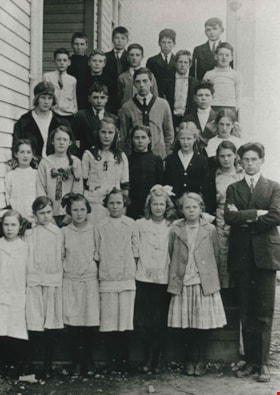
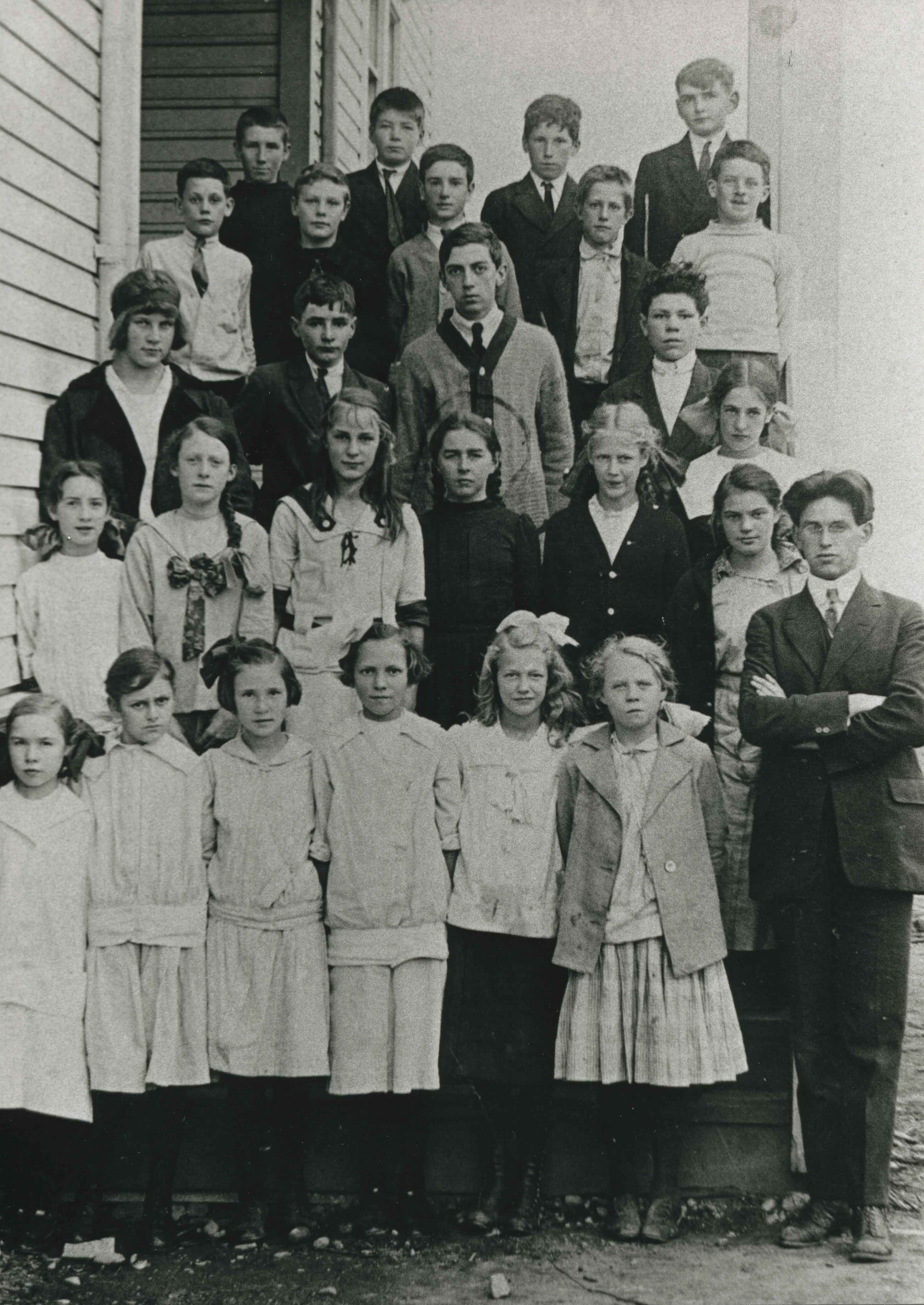
- Photograph of Inman Avenue School class. Marjorie Cassidy is in the 2nd row, 4th from left. The teacher, to the right, is Mr. Lowther. The Cassidy children, from oldest, are Willie, Marjorie, Mary and Katie.
- Repository
- City of Burnaby Archives
- Date
- 1912 (date of original), copied 1986
- Collection/Fonds
- Burnaby Historical Society fonds
- Subseries
- Pioneer Tales subseries
- Physical Description
- 1 photograph : b&w ; 12.7 x 17.8 cm print
- Description Level
- Item
- Record No.
- 204-075
- Access Restriction
- No restrictions
- Reproduction Restriction
- No known restrictions
- Accession Number
- BHS1988-03
- Scope and Content
- Photograph of Inman Avenue School class. Marjorie Cassidy is in the 2nd row, 4th from left. The teacher, to the right, is Mr. Lowther. The Cassidy children, from oldest, are Willie, Marjorie, Mary and Katie.
- Subjects
- Occupations - Teachers
- Media Type
- Photograph
- Notes
- Title based on contents of photograph
- Geographic Access
- Brandon Street
- Street Address
- 3963 Brandon Street
- Historic Neighbourhood
- Central Park (Historic Neighbourhood)
- Planning Study Area
- Garden Village Area
Images
Olive Farrington
https://search.heritageburnaby.ca/link/archivedescription35230
- Repository
- City of Burnaby Archives
- Date
- 1919 (date of original), copied 1986
- Collection/Fonds
- Burnaby Historical Society fonds
- Description Level
- Item
- Physical Description
- 1 photograph : b&w ; 12.7 x 17.8 cm print
- Scope and Content
- Photograph of the Farrington family home at Bond Street and Chisholm Avenue (now Smith Avenue). Olive Farrington is standing in front, centre, with two friends.
- Repository
- City of Burnaby Archives
- Date
- 1919 (date of original), copied 1986
- Collection/Fonds
- Burnaby Historical Society fonds
- Subseries
- Pioneer Tales subseries
- Physical Description
- 1 photograph : b&w ; 12.7 x 17.8 cm print
- Description Level
- Item
- Record No.
- 204-087
- Access Restriction
- No restrictions
- Reproduction Restriction
- No known restrictions
- Accession Number
- BHS1988-03
- Scope and Content
- Photograph of the Farrington family home at Bond Street and Chisholm Avenue (now Smith Avenue). Olive Farrington is standing in front, centre, with two friends.
- Names
- Barber, Olive Farrington
- Media Type
- Photograph
- Notes
- Title based on contents of photograph
- Geographic Access
- Bond Street
- Smith Avenue
- Historic Neighbourhood
- Central Park (Historic Neighbourhood)
- Planning Study Area
- Garden Village Area
Images

![Rav Rampuri and Leonardo DiFrancesco, [2002] thumbnail](/media/hpo/_Data/_Archives_Images/_Unrestricted/535/535-2776.jpg?width=280)
Rav Rampuri and Leonardo DiFrancesco
https://search.heritageburnaby.ca/link/archivedescription97401
- Repository
- City of Burnaby Archives
- Date
- [2002]
- Collection/Fonds
- Burnaby NewsLeader photograph collection
- Description Level
- Item
- Physical Description
- 1 photograph (tiff) : col.
- Scope and Content
- Photograph of real estate agents Rav Rampuri and Leonardo DiFrancesco posing in front of St. John the Divine Church on Kingsway.
- Repository
- City of Burnaby Archives
- Date
- [2002]
- Collection/Fonds
- Burnaby NewsLeader photograph collection
- Physical Description
- 1 photograph (tiff) : col.
- Description Level
- Item
- Record No.
- 535-2776
- Access Restriction
- No restrictions
- Reproduction Restriction
- No restrictions
- Accession Number
- 2018-12
- Scope and Content
- Photograph of real estate agents Rav Rampuri and Leonardo DiFrancesco posing in front of St. John the Divine Church on Kingsway.
- Subjects
- Buildings - Religious - Churches
- Media Type
- Photograph
- Photographer
- Bartel, Mario
- Notes
- Title based on caption
- Collected by editorial for use in a September 2002 issue of the Burnaby NewsLeader
- Caption from metadata: "Rav Rampuri and Leonardo DiFrancesco are Burnaby real estate agents who've made a specialty of selling churches. They recently completed a deal for St. John the Divine church, on Kingsway."
- Geographic Access
- Kingsway
- Street Address
- 3891 Kingsway
- Historic Neighbourhood
- Central Park (Historic Neighbourhood)
- Planning Study Area
- Garden Village Area
Images
![Rav Rampuri and Leonardo DiFrancesco, [2002] thumbnail](/media/hpo/_Data/_Archives_Images/_Unrestricted/535/535-2776.jpg)
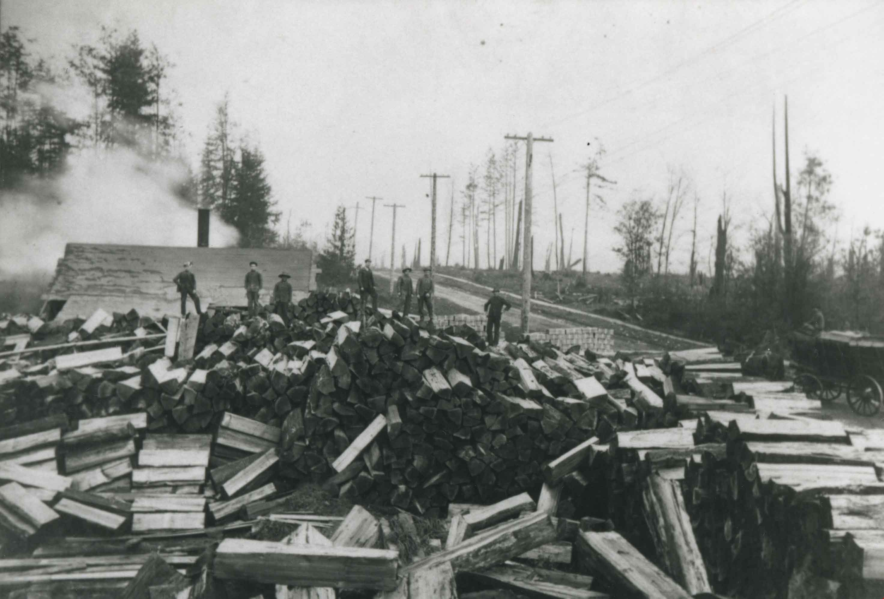
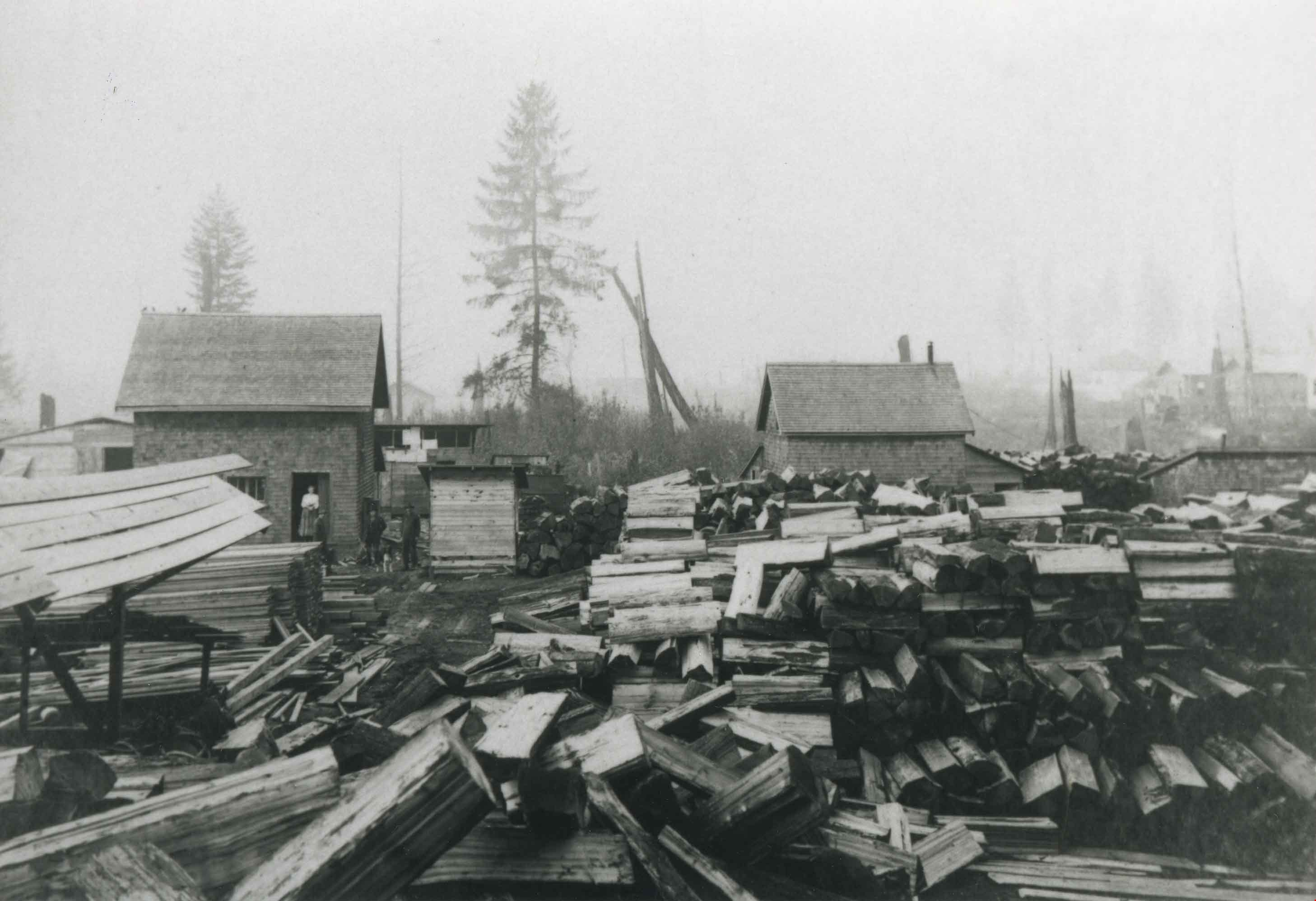
Shingle Mill
https://search.heritageburnaby.ca/link/archivedescription36763
- Repository
- City of Burnaby Archives
- Date
- 1911 (date of original), copied 1992
- Collection/Fonds
- Burnaby Historical Society fonds
- Description Level
- Item
- Physical Description
- 1 photograph : b&w ; 8.6 x 12.6 cm print
- Scope and Content
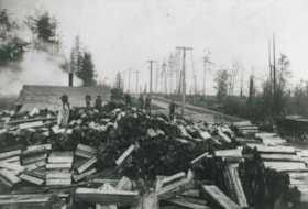
- Photograph of a shingle mill at Burke Street and Inman Avenue. Several men are standing on piles of split logs. A horse and wagon is seen on the right.
- Repository
- City of Burnaby Archives
- Date
- 1911 (date of original), copied 1992
- Collection/Fonds
- Burnaby Historical Society fonds
- Subseries
- Burnaby Centennial Anthology subseries
- Physical Description
- 1 photograph : b&w ; 8.6 x 12.6 cm print
- Description Level
- Item
- Record No.
- 315-118
- Access Restriction
- No restrictions
- Reproduction Restriction
- No known restrictions
- Accession Number
- BHS1994-04
- Scope and Content
- Photograph of a shingle mill at Burke Street and Inman Avenue. Several men are standing on piles of split logs. A horse and wagon is seen on the right.
- Media Type
- Photograph
- Notes
- Title based on contents of photograph
- Geographic Access
- Burke Street
- Inman Avenue
- Historic Neighbourhood
- Central Park (Historic Neighbourhood)
- Planning Study Area
- Garden Village Area
Images
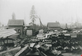
Shingle Mill
https://search.heritageburnaby.ca/link/archivedescription36764
- Repository
- City of Burnaby Archives
- Date
- 1911 (date of original), copied 1992
- Collection/Fonds
- Burnaby Historical Society fonds
- Description Level
- Item
- Physical Description
- 1 photograph : b&w ; 8.7 x 12.6 cm print
- Scope and Content
- Photograph of a shingle mill at Burke Street and Inman Avenue with piles of logs and boards filing the property.
- Repository
- City of Burnaby Archives
- Date
- 1911 (date of original), copied 1992
- Collection/Fonds
- Burnaby Historical Society fonds
- Subseries
- Burnaby Centennial Anthology subseries
- Physical Description
- 1 photograph : b&w ; 8.7 x 12.6 cm print
- Description Level
- Item
- Record No.
- 315-119
- Access Restriction
- No restrictions
- Reproduction Restriction
- No known restrictions
- Accession Number
- BHS1994-04
- Scope and Content
- Photograph of a shingle mill at Burke Street and Inman Avenue with piles of logs and boards filing the property.
- Media Type
- Photograph
- Notes
- Title based on contents of photograph
- Geographic Access
- Burke Street
- Inman Avenue
- Historic Neighbourhood
- Central Park (Historic Neighbourhood)
- Planning Study Area
- Garden Village Area
Images
![Speed Watch at Wesburn Park, [2002] thumbnail](/media/hpo/_Data/_Archives_Images/_Unrestricted/535/535-2761.jpg?width=280)
Speed Watch at Wesburn Park
https://search.heritageburnaby.ca/link/archivedescription97386
- Repository
- City of Burnaby Archives
- Date
- [2002]
- Collection/Fonds
- Burnaby NewsLeader photograph collection
- Description Level
- Item
- Physical Description
- 1 photograph (tiff) : col.
- Scope and Content
- Photograph of Yvonne Petrachuk, a volunteer with the RCMP's Speed Watch program, recording notes on a clipboard on the side of a road near Wesburn Park and wearing a fluorescent safety vest. A car displaying a digital reading of the passing car's speed, set up in the back of a parked vehicle, and a…
- Repository
- City of Burnaby Archives
- Date
- [2002]
- Collection/Fonds
- Burnaby NewsLeader photograph collection
- Physical Description
- 1 photograph (tiff) : col.
- Description Level
- Item
- Record No.
- 535-2761
- Access Restriction
- No restrictions
- Reproduction Restriction
- No restrictions
- Accession Number
- 2018-12
- Scope and Content
- Photograph of Yvonne Petrachuk, a volunteer with the RCMP's Speed Watch program, recording notes on a clipboard on the side of a road near Wesburn Park and wearing a fluorescent safety vest. A car displaying a digital reading of the passing car's speed, set up in the back of a parked vehicle, and another volunteer are visible in the background.
- Media Type
- Photograph
- Photographer
- Bartel, Mario
- Notes
- Title based on caption
- Collected by editorial for use in an August 2002 issue of the Burnaby NewsLeader
- Caption from metadata: "Yvonne Petrachuk, a Speed Watch volunteer, records vehicles at a speed zone near Wesburn Park in Burnaby. With schools reopening on Tuesday, Speed Watch and the RCMP are teaming up to to raise awareness about speeding with their "Two Strikes You're Out" program. At Strike One, the speed reader board displays a vehicle's speed, giving drivers the chance to slow down to the posted limit. If they don't, they risk Strike Two, a speeding ticket from a waiting police officer."
- Geographic Access
- Wesburn Park
- Parkwood Avenue
- Street Address
- 4781 Parkwood Avenue
- Historic Neighbourhood
- Central Park (Historic Neighbourhood)
- Planning Study Area
- Garden Village Area
Images
![Speed Watch at Wesburn Park, [2002] thumbnail](/media/hpo/_Data/_Archives_Images/_Unrestricted/535/535-2761.jpg)
![St. John the Divine Anglican Church for sale, [2001] thumbnail](/media/hpo/_Data/_Archives_Images/_Unrestricted/535/535-2196.jpg?width=280)
St. John the Divine Anglican Church for sale
https://search.heritageburnaby.ca/link/archivedescription96574
- Repository
- City of Burnaby Archives
- Date
- [2001]
- Collection/Fonds
- Burnaby NewsLeader photograph collection
- Description Level
- Item
- Physical Description
- 1 photograph (tiff) : col.
- Scope and Content
- Photograph of the former St. John the Divine Anglican Church at 3895 Kingsway. There is a sign in the foreground that reads: "Offered for Sale."
- Repository
- City of Burnaby Archives
- Date
- [2001]
- Collection/Fonds
- Burnaby NewsLeader photograph collection
- Physical Description
- 1 photograph (tiff) : col.
- Description Level
- Item
- Record No.
- 535-2196
- Access Restriction
- No restrictions
- Reproduction Restriction
- No restrictions
- Accession Number
- 2018-12
- Scope and Content
- Photograph of the former St. John the Divine Anglican Church at 3895 Kingsway. There is a sign in the foreground that reads: "Offered for Sale."
- Subjects
- Buildings - Religious - Churches
- Media Type
- Photograph
- Notes
- Title based on contents of photograph
- Collected by editorial for use in a March 2001 issue of the Burnaby NewsLeader
- Geographic Access
- Kingsway
- Street Address
- 3895 Kingsway
- Historic Neighbourhood
- Central Park (Historic Neighbourhood)
- Planning Study Area
- Garden Village Area
Images
![St. John the Divine Anglican Church for sale, [2001] thumbnail](/media/hpo/_Data/_Archives_Images/_Unrestricted/535/535-2196.jpg)
![St. John the Divine Anglican Church renovations, [2005] thumbnail](/media/hpo/_Data/_Archives_Images/_Unrestricted/535/535-1876.jpg?width=280)
St. John the Divine Anglican Church renovations
https://search.heritageburnaby.ca/link/archivedescription96179
- Repository
- City of Burnaby Archives
- Date
- [2005]
- Collection/Fonds
- Burnaby NewsLeader photograph collection
- Description Level
- Item
- Physical Description
- 1 photograph (tiff) : col.
- Scope and Content
- Photograph of two workers from Companion Construction cutting a board during renovations to St. John the Divine Anglican Church on Kingsway, after it was designated as a heritage site.
- Repository
- City of Burnaby Archives
- Date
- [2005]
- Collection/Fonds
- Burnaby NewsLeader photograph collection
- Physical Description
- 1 photograph (tiff) : col.
- Description Level
- Item
- Record No.
- 535-1876
- Access Restriction
- No restrictions
- Reproduction Restriction
- No restrictions
- Accession Number
- 2018-12
- Scope and Content
- Photograph of two workers from Companion Construction cutting a board during renovations to St. John the Divine Anglican Church on Kingsway, after it was designated as a heritage site.
- Media Type
- Photograph
- Photographer
- Bartel, Mario
- Notes
- Title based on caption
- Collected by editorial for use in a January 2005 issue of the Burnaby NewsLeader
- Caption from metadata: "Gary Janzen and Ron Koehn, of Companion Construction, are nearing completion of a six-month project to renovate St. John the Divine Church, on Kingsway in Burnaby. The church is the oldest in Burnaby, built in 1905, and has been designated a heritage site. When the work is completed, it will be sold."
- Geographic Access
- Kingsway
- Street Address
- 3891 Kingsway
- Historic Neighbourhood
- Central Park (Historic Neighbourhood)
- Planning Study Area
- Garden Village Area
Images
![St. John the Divine Anglican Church renovations, [2005] thumbnail](/media/hpo/_Data/_Archives_Images/_Unrestricted/535/535-1876.jpg)
![St. John the Divine Anglican Church restoration, [2005] thumbnail](/media/hpo/_Data/_Archives_Images/_Unrestricted/535/535-1950.jpg?width=280)
St. John the Divine Anglican Church restoration
https://search.heritageburnaby.ca/link/archivedescription96267
- Repository
- City of Burnaby Archives
- Date
- [2005]
- Collection/Fonds
- Burnaby NewsLeader photograph collection
- Description Level
- Item
- Physical Description
- 1 photograph (tiff) : col.
- Scope and Content
- Photograph of Ron Koehn of Companion Construction Ltd. standing inside the restored St. John the Divine Church in Burnaby. Koehn is standing next to the large, newly-installed stained glass windows.
- Repository
- City of Burnaby Archives
- Date
- [2005]
- Collection/Fonds
- Burnaby NewsLeader photograph collection
- Physical Description
- 1 photograph (tiff) : col.
- Description Level
- Item
- Record No.
- 535-1950
- Access Restriction
- No restrictions
- Reproduction Restriction
- No restrictions
- Accession Number
- 2018-12
- Scope and Content
- Photograph of Ron Koehn of Companion Construction Ltd. standing inside the restored St. John the Divine Church in Burnaby. Koehn is standing next to the large, newly-installed stained glass windows.
- Media Type
- Photograph
- Photographer
- Bartel, Mario
- Notes
- Title based on caption
- Collected by editorial for use in a February 2005 issue of the Burnaby NewsLeader
- Caption from metadata: "Ron Koehn, of Companion Construction Ltd., admires the newly-installed stain glass windows at St. John the Divine Church in Burnaby. The church, the oldest in the city, is nearing completion of a restoration project before it will be sold to new owners."
- Geographic Access
- Kingsway
- Street Address
- 3891 Kingsway
- Historic Neighbourhood
- Central Park (Historic Neighbourhood)
- Planning Study Area
- Garden Village Area
Images
![St. John the Divine Anglican Church restoration, [2005] thumbnail](/media/hpo/_Data/_Archives_Images/_Unrestricted/535/535-1950.jpg)
![St. John the Divine Church, [191-] thumbnail](/media/hpo/_Data/_Archives_Images/_Unrestricted/371/449-011.jpg?width=280)
St. John the Divine Church
https://search.heritageburnaby.ca/link/archivedescription38516
- Repository
- City of Burnaby Archives
- Date
- [191-]
- Collection/Fonds
- Burnaby Historical Society fonds
- Description Level
- Item
- Physical Description
- 1 photograph : b&w postcard ; 8.5 x 14 cm
- Scope and Content
- Photographic postcard of St. John the Divine church at Kingsway and Central Park.
- Repository
- City of Burnaby Archives
- Date
- [191-]
- Collection/Fonds
- Burnaby Historical Society fonds
- Subseries
- Photographs subseries
- Physical Description
- 1 photograph : b&w postcard ; 8.5 x 14 cm
- Description Level
- Item
- Record No.
- 449-011
- Access Restriction
- No restrictions
- Reproduction Restriction
- No restrictions
- Accession Number
- BHS2007-04
- Scope and Content
- Photographic postcard of St. John the Divine church at Kingsway and Central Park.
- Media Type
- Photograph
- Notes
- Title based on contents of photograph
- Geographic Access
- Central Park
- Kingsway
- Street Address
- 3891 Kingsway
- Historic Neighbourhood
- Central Park (Historic Neighbourhood)
- Planning Study Area
- Garden Village Area
Images
![St. John the Divine Church, [191-] thumbnail](/media/hpo/_Data/_Archives_Images/_Unrestricted/371/449-011.jpg)
![Thomas Sanderson home, [1910] (date of original), copied 1986 thumbnail](/media/hpo/_Data/_Archives_Images/_Unrestricted/204/204-125.jpg?width=280)
Thomas Sanderson home
https://search.heritageburnaby.ca/link/archivedescription35268
- Repository
- City of Burnaby Archives
- Date
- [1910] (date of original), copied 1986
- Collection/Fonds
- Burnaby Historical Society fonds
- Description Level
- Item
- Physical Description
- 1 photograph : b&w ; 12.7 x 17.8 cm print
- Scope and Content
- Photograph of Sanderson family home at Inman Avenue and Maxwell Street (now Thurston Street) in the Central Park district. Tom Sanderson was born in this house. A larger house which still stands on this property replaced this house in 1921.
- Repository
- City of Burnaby Archives
- Date
- [1910] (date of original), copied 1986
- Collection/Fonds
- Burnaby Historical Society fonds
- Subseries
- Pioneer Tales subseries
- Physical Description
- 1 photograph : b&w ; 12.7 x 17.8 cm print
- Description Level
- Item
- Record No.
- 204-125
- Access Restriction
- No restrictions
- Reproduction Restriction
- No known restrictions
- Accession Number
- BHS1988-03
- Scope and Content
- Photograph of Sanderson family home at Inman Avenue and Maxwell Street (now Thurston Street) in the Central Park district. Tom Sanderson was born in this house. A larger house which still stands on this property replaced this house in 1921.
- Subjects
- Buildings - Residential - Houses
- Media Type
- Photograph
- Notes
- Title based on contents of photograph
- Geographic Access
- Inman Avenue
- Street Address
- 5457 Inman Avenue
- Historic Neighbourhood
- Central Park (Historic Neighbourhood)
- Planning Study Area
- Garden Village Area
Images
![Thomas Sanderson home, [1910] (date of original), copied 1986 thumbnail](/media/hpo/_Data/_Archives_Images/_Unrestricted/204/204-125.jpg)