Narrow Results By
Subject
- Buildings - Commercial 2
- Buildings - Schools 1
- Ceremonies - Weddings 1
- Clothing - Military Uniforms 1
- Geographic Features - Roads 1
- Natural Phenomena - Snow 1
- Occupations - Telephone Operators 1
- Organizations - Girls' Societies and Clubs 1
- Personal Symbols - Certificates 1
- Telecommunication Tools and Equipment 1
Bus Route Extension in the Central Park Garden Village Area
https://search.heritageburnaby.ca/link/councilreport43728
- Repository
- City of Burnaby Archives
- Report ID
- 43594
- Meeting Date
- 24-Aug-1956
- Format
- Council - Mayor/Councillor/Staff Report
- Collection/Fonds
- City Council and Office of the City Clerk fonds
- Repository
- City of Burnaby Archives
- Report ID
- 43594
- Meeting Date
- 24-Aug-1956
- Format
- Council - Mayor/Councillor/Staff Report
- Collection/Fonds
- City Council and Office of the City Clerk fonds
Documents
Street System in Central Park Garden Village Area
https://search.heritageburnaby.ca/link/councilreport41133
- Repository
- City of Burnaby Archives
- Report ID
- 37944
- Meeting Date
- 14-Dec-1959
- Format
- Council - Committee Report
- Collection/Fonds
- City Council and Office of the City Clerk fonds
- Repository
- City of Burnaby Archives
- Report ID
- 37944
- Meeting Date
- 14-Dec-1959
- Format
- Council - Committee Report
- Collection/Fonds
- City Council and Office of the City Clerk fonds
Documents

Garden Village Neighbourhood
https://search.heritageburnaby.ca/link/landmark800
- Repository
- Burnaby Heritage Planning
- Associated Dates
- 1955-2008
- Heritage Value
- Bounded by Moscrop Street to the north, Kingsway and Grange to the south, Willingdon to the east and Boundary Road to the west, the Garden Village Neighbourhood is characterised as a primarily residential area that is well-served due to its proximity to commercial, park and business centres. The north-east corner of the neighbourhood is a typical 1950s subdivision of mostly single family homes located on an irregular street pattern, while the remaining areas saw some transition to multi-family housing types throughout the 1970s and up to the current time.
- Historic Neighbourhood
- Central Park (Historic Neighbourhood)
- Planning Study Area
- Garden Village Area
Images

![Boundary Road and Kingsway, [1959] thumbnail](/media/Hpo/_Data/_Archives_Images/_Unrestricted/001/113-001.jpg?width=280)
Boundary Road and Kingsway
https://search.heritageburnaby.ca/link/archivedescription34709
- Repository
- City of Burnaby Archives
- Date
- [1959]
- Collection/Fonds
- Burnaby Historical Society fonds
- Description Level
- Item
- Physical Description
- 1 photograph : b&w ; 16.0 x 25.3 cm
- Scope and Content
- Photograph of buildings at Boundary Road and Kingsway, southwest corner. A typed description on the back of the photograph reads, "The new Hemlock (automatic) and old Dexter (manual) exchanges. / B.C. Telephone Company."
- Repository
- City of Burnaby Archives
- Date
- [1959]
- Collection/Fonds
- Burnaby Historical Society fonds
- Subseries
- Photographs subseries
- Physical Description
- 1 photograph : b&w ; 16.0 x 25.3 cm
- Description Level
- Item
- Record No.
- 113-001
- Access Restriction
- No restrictions
- Reproduction Restriction
- Reproduce for fair dealing purposes only
- Accession Number
- BHS2007-04
- Scope and Content
- Photograph of buildings at Boundary Road and Kingsway, southwest corner. A typed description on the back of the photograph reads, "The new Hemlock (automatic) and old Dexter (manual) exchanges. / B.C. Telephone Company."
- Media Type
- Photograph
- Photographer
- Williams Brothers Photographers Limited
- Notes
- Title based on contents of photograph
- Stamp on back of photograph reads, "Williams Bros. Photographers Ltd. / 413 Granville St. Vancouver 2, B.C. / Phone Tatlow 8588"
- Geographic Access
- Boundary Road
- Kingsway
- Historic Neighbourhood
- Central Park (Historic Neighbourhood)
- Planning Study Area
- Garden Village Area
Images
![Boundary Road and Kingsway, [1959] thumbnail](/media/Hpo/_Data/_Archives_Images/_Unrestricted/001/113-001.jpg)
Fire insurance plans - Greater Vancouver - Volume XVII - Municipality of Burnaby
https://search.heritageburnaby.ca/link/museumdescription17797
- Repository
- Burnaby Village Museum
- Date
- 1927-1950
- Collection/Fonds
- Burnaby Village Museum Map collection
- Description Level
- Item
- Physical Description
- 4 plans on 4 sheets : col. lithographic prints
- Scope and Content
- Item consists of fire insurance plans titled "Greater Vancouver / Volume XVII / Municipality / of Burnaby" surveyed May 1927, revised in October 1940 and September 1950. Includes a two page key plan (E and F) and two associated plans numbered 1729 and 1738 (located within District Lot 35).
- Repository
- Burnaby Village Museum
- Collection/Fonds
- Burnaby Village Museum Map collection
- Description Level
- Item
- Physical Description
- 4 plans on 4 sheets : col. lithographic prints
- Scope and Content
- Item consists of fire insurance plans titled "Greater Vancouver / Volume XVII / Municipality / of Burnaby" surveyed May 1927, revised in October 1940 and September 1950. Includes a two page key plan (E and F) and two associated plans numbered 1729 and 1738 (located within District Lot 35).
- Publisher
- Plan Department of Fire Branch of British Columbia Underwriters' Association
- Accession Code
- BV987.1.70
- Access Restriction
- No restrictions
- Reproduction Restriction
- May be restricted by third party rights
- Date
- 1927-1950
- Media Type
- Cartographic Material
- Historic Neighbourhood
- Central Park (Historic Neighbourhood)
- Planning Study Area
- Garden Village Area
- Scan Resolution
- 400
- Scan Date
- 2021-11-17
- Notes
- Title based on contents of item
- These plans were removed from a bound book with labels on cover page reading: "Plan No. 90 / THIS INSURANCE PLAN / of / Vancouver VOLUME "8" / IN THE PROPERTY OF THE / British Columbia Insurance Underwriter's Association / Vancouver B.C. / AND IS LOANED / MELVILLE F. THOMSON CO. .../ Date May 26th, 1934"; / "Plan No. 74 / THIS INSURANCE PLAN / OF / VANCOUVER VOLUME "9"" / Plan No. 11 / THIS INSURANCE PLAN / OF / BURNABY VOLUMES 15-19" / "THIS PLAN IS THE PROPERTY OF / THE / BRITISH LAW INSURANCE COMPANY / LIMITED"
- Contact Burnaby Village Museum to view associated fire insurance plans XVIII
Graduation records
https://search.heritageburnaby.ca/link/archivedescription82734
- Repository
- City of Burnaby Archives
- Date
- [1930-1941]
- Collection/Fonds
- Hazel Simnett collection
- Description Level
- File
- Physical Description
- 1 folder of textual records
- Scope and Content
- File consists of two envelopes and one dictionary. One envelope is empty and is addressed to: "To Whom it May Concern" and is from: "Hugh M. Fraser High School / 2350 Kingsway / New Westminster, BC". It most likely contained the reference letter from May 12, 1941 written by the principal of Hugh M.…
- Repository
- City of Burnaby Archives
- Date
- [1930-1941]
- Collection/Fonds
- Hazel Simnett collection
- Physical Description
- 1 folder of textual records
- Description Level
- File
- Record No.
- MSS167-013
- Accession Number
- 2013-22
- Scope and Content
- File consists of two envelopes and one dictionary. One envelope is empty and is addressed to: "To Whom it May Concern" and is from: "Hugh M. Fraser High School / 2350 Kingsway / New Westminster, BC". It most likely contained the reference letter from May 12, 1941 written by the principal of Hugh M. Fraser Senior and Junior High Schools. The second envelope is addressed to "Miss Hazel Simnett / 4019 Kingsway / New Westminster, BC" from the Department of Education in Victoria, BC. It contains the reference letter as discussed previously, a University Entrance Examination certificate, a High School Graduation certificate from Burnaby South High School, a Grade Twelve Examination Junior Matriculation certificate and a purple and gold ribbon. The dictionary is a Nelson's "Highroads" English Dictionary. Inside an inscription reads: "Hazel Simnett / 4019 Kingsway / Burnaby / BSHS / Hazel Simnett / Kingsway West School".
- Subjects
- Personal Symbols - Certificates
- Names
- Simnett, Hazel
- Media Type
- Textual Record
- Notes
- Title based on contents of file
- Simnett personal papers series
- Geographic Access
- Kingsway
- Historic Neighbourhood
- Central Park (Historic Neighbourhood)
- Planning Study Area
- Garden Village Area
Inman, Burnaby, B.C.
https://search.heritageburnaby.ca/link/archivedescription66388
- Repository
- City of Burnaby Archives
- Date
- 1954
- Collection/Fonds
- Grieve family fonds
- Description Level
- Item
- Physical Description
- 1 photograph : b&w ; 11.5 x 16.5 cm
- Scope and Content
- Photograph of the exterior of Inman Avenue School.
- Repository
- City of Burnaby Archives
- Date
- 1954
- Collection/Fonds
- Grieve family fonds
- Physical Description
- 1 photograph : b&w ; 11.5 x 16.5 cm
- Description Level
- Item
- Record No.
- 523-002
- Access Restriction
- No restrictions
- Reproduction Restriction
- No known restrictions
- Accession Number
- 2011-04
- Scope and Content
- Photograph of the exterior of Inman Avenue School.
- Subjects
- Buildings - Schools
- Names
- Inman Avenue School
- Media Type
- Photograph
- Notes
- Title based on contents of photograph
- Photographer's writing (engraved on negative) reads: "Layton / Inman. Burnaby, B.C. / 1954"
- Geographic Access
- Brandon Street
- Street Address
- 3963 Brandon Street
- Historic Neighbourhood
- Central Park (Historic Neighbourhood)
- Planning Study Area
- Garden Village Area
![Kathy Hardy, [ca. 1955] thumbnail](/media/hpo/_Data/_BVM_Images/2015/2015_0036_0115_001.jpg?width=280)
Kathy Hardy
https://search.heritageburnaby.ca/link/museumdescription4967
- Repository
- Burnaby Village Museum
- Date
- [ca. 1955]
- Collection/Fonds
- Burnaby Girl Guides fonds
- Description Level
- Item
- Physical Description
- 1 photograph : b&w ; 10 x 7 cm
- Scope and Content
- Photograph of Kathyrn "Kathy" Raadsheer (nee Hardy) dressed in her Brownie uniform standing outside a house which could be her family home located at 4337 Wildwood Cresent Burnaby.
- Repository
- Burnaby Village Museum
- Collection/Fonds
- Burnaby Girl Guides fonds
- Description Level
- Item
- Physical Description
- 1 photograph : b&w ; 10 x 7 cm
- Scope and Content
- Photograph of Kathyrn "Kathy" Raadsheer (nee Hardy) dressed in her Brownie uniform standing outside a house which could be her family home located at 4337 Wildwood Cresent Burnaby.
- Geographic Access
- Wildwood Crescent
- Street Address
- 4337 Wildwood Crescent
- Accession Code
- BV015.36.115
- Access Restriction
- No restrictions
- Reproduction Restriction
- May be restricted by third party rights
- Date
- [ca. 1955]
- Media Type
- Photograph
- Historic Neighbourhood
- Central Park (Historic Neighbourhood)
- Planning Study Area
- Garden Village Area
- Arrangement
- Photographs and slides were arranged by Kathyrn Raadsheer (nee Hardy)
- Scan Resolution
- 600
- Scan Date
- March 10, 2021
- Scale
- 100
- Notes
- Title based on contents of photograph
- Photograph is part of scrapbook (page 2/10) BV015.36.82.
Images
![Kathy Hardy, [ca. 1955] thumbnail](/media/hpo/_Data/_BVM_Images/2015/2015_0036_0115_001.jpg)
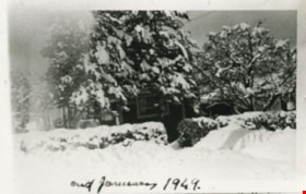
Shankie family home
https://search.heritageburnaby.ca/link/archivedescription35145
- Repository
- City of Burnaby Archives
- Date
- January 1949 (date of original), copied 1986
- Collection/Fonds
- Burnaby Historical Society fonds
- Description Level
- Item
- Physical Description
- 1 photograph : b&w ; 12.7 x 17.8 cm print
- Scope and Content
- Photograph of "Campend," the Shankie family home. This photograph was taken following winter snows. The house was formerly numbered 3718 Barker Avenue and later renumbered 5155 Barker Avenue.
- Repository
- City of Burnaby Archives
- Date
- January 1949 (date of original), copied 1986
- Collection/Fonds
- Burnaby Historical Society fonds
- Subseries
- Pioneer Tales subseries
- Physical Description
- 1 photograph : b&w ; 12.7 x 17.8 cm print
- Description Level
- Item
- Record No.
- 204-002
- Access Restriction
- No restrictions
- Reproduction Restriction
- Reproduce for fair dealing purposes only
- Accession Number
- BHS1988-03
- Scope and Content
- Photograph of "Campend," the Shankie family home. This photograph was taken following winter snows. The house was formerly numbered 3718 Barker Avenue and later renumbered 5155 Barker Avenue.
- Subjects
- Natural Phenomena - Snow
- Media Type
- Photograph
- Notes
- Title based on contents of photograph
- Geographic Access
- Barker Avenue
- Street Address
- 5155 Barker Avenue
- Historic Neighbourhood
- Central Park (Historic Neighbourhood)
- Planning Study Area
- Garden Village Area
Images


Switchboard
https://search.heritageburnaby.ca/link/archivedescription34710
- Repository
- City of Burnaby Archives
- Date
- 1943
- Collection/Fonds
- Burnaby Historical Society fonds
- Description Level
- Item
- Physical Description
- 1 photograph : b&w ; 20.0 x 25.5 cm
- Scope and Content
- Photograph of the interior of a switchboard, probably the Dexter exchange at Boundary Road and Kingsway. A typed description on the back of the photograph reads, "A Manual Switchboard, typical of about 25 years ago. / Dexter, 1943. / B.C. Telephone Company."
- Repository
- City of Burnaby Archives
- Date
- 1943
- Collection/Fonds
- Burnaby Historical Society fonds
- Subseries
- Photographs subseries
- Physical Description
- 1 photograph : b&w ; 20.0 x 25.5 cm
- Material Details
- Printed on photo paper: "selo"
- Description Level
- Item
- Record No.
- 114-001
- Access Restriction
- No restrictions
- Reproduction Restriction
- No known restrictions
- Accession Number
- BHS2007-04
- Scope and Content
- Photograph of the interior of a switchboard, probably the Dexter exchange at Boundary Road and Kingsway. A typed description on the back of the photograph reads, "A Manual Switchboard, typical of about 25 years ago. / Dexter, 1943. / B.C. Telephone Company."
- Subjects
- Telecommunication Tools and Equipment
- Buildings - Commercial
- Occupations - Telephone Operators
- Media Type
- Photograph
- Photographer
- Dominion Photo Company
- Notes
- Title based on contents of photograph
- Printed in bottom left corner of photograph, "27038 Dominion Photo Co., Vancouver B.C."
- Geographic Access
- Boundary Road
- Kingsway
- Historic Neighbourhood
- Central Park (Historic Neighbourhood)
- Planning Study Area
- Garden Village Area
Images

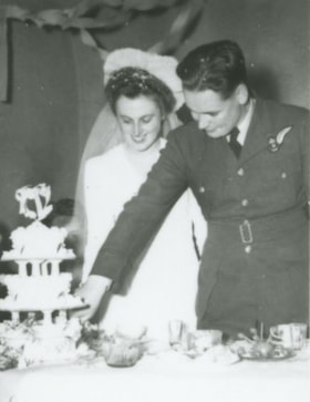
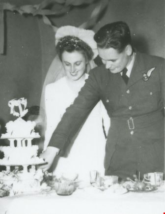
Wedding of Vera and Albert Bruce
https://search.heritageburnaby.ca/link/archivedescription37809
- Repository
- City of Burnaby Archives
- Date
- November 21, 1944 (date of original), copied 1991
- Collection/Fonds
- Burnaby Historical Society fonds
- Description Level
- Item
- Physical Description
- 1 photograph : b&w ; 4.4 x 3.1 cm print on contact sheet 20.7 x 26.7 cm
- Scope and Content
- Photograph of Vera and Albert Bruce cutting the cake at their wedding at St. John the Divine Anglican Church near Central Park. Albert is in uniform.
- Repository
- City of Burnaby Archives
- Date
- November 21, 1944 (date of original), copied 1991
- Collection/Fonds
- Burnaby Historical Society fonds
- Subseries
- Burnaby Image Bank subseries
- Physical Description
- 1 photograph : b&w ; 4.4 x 3.1 cm print on contact sheet 20.7 x 26.7 cm
- Description Level
- Item
- Record No.
- 370-397
- Access Restriction
- No restrictions
- Reproduction Restriction
- No known restrictions
- Accession Number
- BHS1999-03
- Scope and Content
- Photograph of Vera and Albert Bruce cutting the cake at their wedding at St. John the Divine Anglican Church near Central Park. Albert is in uniform.
- Media Type
- Photograph
- Notes
- Title based on contents of photograph
- 1 b&w copy negative accompanying
- Negative has a pink cast
- Geographic Access
- Kingsway
- Street Address
- 3891 Kingsway
- Historic Neighbourhood
- Central Park (Historic Neighbourhood)
- Planning Study Area
- Garden Village Area
Images