
Canadian Food Market
https://search.heritageburnaby.ca/link/archivedescription98666
- Repository
- City of Burnaby Archives
- Date
- 2022
- Collection/Fonds
- Disappearing Burnaby collection
- Description Level
- Item
- Physical Description
- 1 photograph (jpeg) : col.
- Scope and Content
- Photograph of the exterior of the Canadian Food Market, taken from across Imperial Street at night. The grocery store is located at 4378 Imperial Street and the building was constructed in 1962. A large display of plants and flowers stands in front of the store and is illuminated by bright lights.
- Repository
- City of Burnaby Archives
- Date
- 2022
- Collection/Fonds
- Disappearing Burnaby collection
- Physical Description
- 1 photograph (jpeg) : col.
- Description Level
- Item
- Record No.
- 634-013
- Access Restriction
- No restrictions
- Reproduction Restriction
- No restrictions
- Accession Number
- 2022-14
- Scope and Content
- Photograph of the exterior of the Canadian Food Market, taken from across Imperial Street at night. The grocery store is located at 4378 Imperial Street and the building was constructed in 1962. A large display of plants and flowers stands in front of the store and is illuminated by bright lights.
- Media Type
- Photograph
- Photographer
- Cheung, Nakita
- Notes
- Title taken from the associated blog post
- Associated blog post: https://disappearingburnaby.wordpress.com/2022/02/20/imperial-manor-2/
- Geographic Access
- Imperial Street
- Street Address
- 4378 Imperial Street
- Historic Neighbourhood
- Central Park (Historic Neighbourhood)
- Planning Study Area
- Sussex-Nelson Area
Images

Relief and Food Allowance for Dependents
https://search.heritageburnaby.ca/link/councilreport55816
- Repository
- City of Burnaby Archives
- Report ID
- 72187
- Meeting Date
- 21-Mar-1934
- Format
- Council - Mayor/Councillor/Staff Report
- Collection/Fonds
- City Council and Office of the City Clerk fonds
- Repository
- City of Burnaby Archives
- Report ID
- 72187
- Meeting Date
- 21-Mar-1934
- Format
- Council - Mayor/Councillor/Staff Report
- Collection/Fonds
- City Council and Office of the City Clerk fonds
Documents

Crystal Mall
https://search.heritageburnaby.ca/link/archivedescription95119
- Repository
- City of Burnaby Archives
- Date
- March 25, 2020
- Collection/Fonds
- Burnaby Photographic Society fonds
- Description Level
- Item
- Physical Description
- 1 photograph (tiff)
- Scope and Content
- Photograph of an empty food court at Crystal Mall. All tables are closed off with caution tape and the restaurants are closed.
- Repository
- City of Burnaby Archives
- Date
- March 25, 2020
- Collection/Fonds
- Burnaby Photographic Society fonds
- Physical Description
- 1 photograph (tiff)
- Description Level
- Item
- Record No.
- 623-037
- Access Restriction
- No restrictions
- Reproduction Restriction
- No restrictions
- Accession Number
- 2020-10
- Scope and Content
- Photograph of an empty food court at Crystal Mall. All tables are closed off with caution tape and the restaurants are closed.
- Subjects
- Buildings - Commercial - Malls
- Media Type
- Photograph
- Photographer
- Cheung, Ray
- Notes
- Transcribed title
- Geographic Access
- Kingsway
- Street Address
- 4500 Kingsway
- Historic Neighbourhood
- Central Park (Historic Neighbourhood)
- Planning Study Area
- Maywood Area
Images

James Massey family fonds
https://search.heritageburnaby.ca/link/archivedescription88394
- Repository
- City of Burnaby Archives
- Date
- 1933-1953 (date of originals), copied 2014
- Collection/Fonds
- James Massey family fonds
- Description Level
- Fonds
- Physical Description
- 18 photographs (tiffs) ; 600 dpi
- Scope and Content
- Records consist of 14 digitized photographs of Robert Burnaby Park and the Massey family with views of buildings, gardens, and trails.
- Repository
- City of Burnaby Archives
- Date
- 1933-1953 (date of originals), copied 2014
- Collection/Fonds
- James Massey family fonds
- Physical Description
- 18 photographs (tiffs) ; 600 dpi
- Material Details
- Tiffs are copies of original photographs
- Description Level
- Fonds
- Access Restriction
- No restrictions
- Reproduction Restriction
- May be restricted by third party rights
- Accession Number
- 2014-34
- Scope and Content
- Records consist of 14 digitized photographs of Robert Burnaby Park and the Massey family with views of buildings, gardens, and trails.
- History
- James Massey was born in Lancaster, England, in 1890 and immigrated to Burnaby in 1910. He married Alice Wilcock who also immigrated to Canada from Lancaster. James and Alice (Willcock) Massey were married in New Westminster on September 11, 1912. The couple built a house on three adjoining lots on the south side of 13th Avenue in Burnaby near Cumberland Road. James and Alice had three daughters, Betty, Grace, and Evelyn. James worked in road construction for the Burnaby Municipality, assisting to build Sperling Avenue (formerly named Pole Line Road) in 1912. He also worked in the brick yard in the glen behind the B.C. Penitentiary, which was owned by the Cogband family. In 1933, James accepted the job of caretaker for Robert Burnaby Park and moved his family onto the property. He was paid 30 dollars a week and the house was rent-free, leaving the family to rent out their house on 13th Avenue for extra revenue. The house that they moved into in Robert Burnaby Park was formerly owned by the Ramsey family and was a pre-fabricated design with no bathroom and a wood stove in the kitchen for heating. The park is situated south of Burnaby Lake on District Lots 87, 89, and 90. The land was originally owned by the Ramsey family, who purchased the property in 1905 and then sold it to Mr. Vidal in 1909. Annie Ramsey bought it back in 1917, but lost it to the city through tax sale proceedings where she entered into a lease agreement allowing her to live on the property until her death in 1926. As the caretaker of Robert Burnaby Park and Burnaby Lake, James also fulfilled the role of game warden. In his role as game warden, James would watch for any poachers, pull traps, take any firearms from children and also act as a deputy for the Provincial Police, which later became the R.C.M.P. The Massey family's dog, Pete, a spaniel cross, assisted Jim in tracking down any traps. Mr. Massey had three aviaries on the park property, where he raised canaries, and in 1939, he installed a goldfish pond. He was also responsible for constructing a playground and raising the flag up the flag pole on all public holidays. The family built a greenhouse behind their house to grow plants for the extensive park gardens. James' brother was the caretaker of Queens Park in New Westminster and assisted him in the planning and design of the gardens. During the 1930s, many unemployed script worked for Mr. Massey in clearing land and building trails and a bridge within the park. A garage was built at the foot of 2nd Street with two additional rooms built by Mr. Massey with the intention of them being used by the Parks Board. However, it was never used for this purpose and the Air Raid Patrol building from the 2nd Street School grounds was moved to the park and used for storage. The Army for the Common Good gardens were located on the west side of Hill Avenue with a shed for tools. The Army of the Common Good grew food and distributed it within the community to those in need during the Depression. The Massey family moved from the park in 1947 and James decided to run for the Burnaby School in the early 1950s. James retired at 65 years of age but continued to work as a custodian at the Armstrong Avenue School until the age of 72. James died in 1985 in Princeton, B.C., at the age of 95.
- Media Type
- Photograph
- Creator
- Massey family
- Notes
- Title based on contents of fonds
- Photo catalogue 581

Joey Restaurant
https://search.heritageburnaby.ca/link/archivedescription95118
- Repository
- City of Burnaby Archives
- Date
- April 1, 2020
- Collection/Fonds
- Burnaby Photographic Society fonds
- Description Level
- Item
- Physical Description
- 1 photograph (tiff)
- Scope and Content
- Photograph of a sign perched on a decorative tree trunk in the foyer of Joey Burnaby. The sign contains information for patrons on food delivery and pickup.
- Repository
- City of Burnaby Archives
- Date
- April 1, 2020
- Collection/Fonds
- Burnaby Photographic Society fonds
- Physical Description
- 1 photograph (tiff)
- Description Level
- Item
- Record No.
- 623-036
- Access Restriction
- No restrictions
- Reproduction Restriction
- No restrictions
- Accession Number
- 2020-10
- Scope and Content
- Photograph of a sign perched on a decorative tree trunk in the foyer of Joey Burnaby. The sign contains information for patrons on food delivery and pickup.
- Media Type
- Photograph
- Photographer
- Cheung, Ray
- Notes
- Transcribed title
- Photographer's caption: "Most restaurants were only open for take-away"
- Geographic Access
- Rosser Avenue
- Street Address
- 1901 Rosser Avenue
- Planning Study Area
- Willingdon Heights Area
Images

Oakalla Prison fonds
https://search.heritageburnaby.ca/link/archivedescription100561
- Repository
- City of Burnaby Archives
- Date
- 1911-1953
- Collection/Fonds
- Oakalla Prison fonds
- Description Level
- Fonds
- Physical Description
- 6 cm. of textual records.
- Scope and Content
- Fonds consists of records created by the Oakalla Prison Farm, including administrative correspondence related to staff appointments and wages, and a staff shortage when employees left to fight in World War I. The records pertain only to staffmembers of the prison and are not directly related to any…
- Repository
- City of Burnaby Archives
- Date
- 1911-1953
- Collection/Fonds
- Oakalla Prison fonds
- Physical Description
- 6 cm. of textual records.
- Description Level
- Fonds
- Record No.
- 66669
- Access Restriction
- No restrictions
- Reproduction Restriction
- No restrictions
- Accession Number
- 2022-13
- Scope and Content
- Fonds consists of records created by the Oakalla Prison Farm, including administrative correspondence related to staff appointments and wages, and a staff shortage when employees left to fight in World War I. The records pertain only to staffmembers of the prison and are not directly related to any prison inmates.
- History
- The Oakalla Prison Farm was a model prison farm on 185 acres (75 ha) of land next to Deer Lake, Burnaby. The Oakalla Prison Farm was a full-service facility that originally opened on September 2, 1912, and was initially designed to hold 150 men and women. The first inmate was William Daley, sentenced on July 31, 1912 to serve a year of hard labor for stealing some fountain pens valued at over $10. By April 30, 1913, some 328 prisoners had passed through the jail's doors. In 1916, the women's section officially opened, and in 1942, the women's unit opened on the grounds as a separate facility. It was renamed as the "Lakeside Correctional Centre for Women" in 1979. The original women's unit was expanded in 1953, and consisted of two cottage-style buildings. By the 1950s, the population was well over 1000. As a working farm, the prison had its own dairy, vegetable gardens, and livestock. Executions in British Columbia were primarily carried out in Oakalla; after 1919, it was the sole penitentiary where executions took place. The first execution was that of 25 year-old Alex Ignace on August 29, 1919. 44 prisoners were executed by hanging at Oakalla from 1919 until the death penalty was abolished in 1959. In 1959, the last execution in British Columbia took place at Oakalla, with the hanging of former sailor Leo Mantha, aged 33. Oakalla was also one of the locations that undertook the experiment of performing cosmetic surgery on inmates to remove deformities that made prisoners "more likely to offend". The experiment was led by Dr. Edward Lewison, and continued into the mid-1960s. Procedures were conducted on 450 inmates, voluntarily. In 1970, the prison was renamed as the Lower Mainland Regional Correctional Centre (LMRCC) The farm portion of the prison, providing work for the inmates and food in the prison, closed in 1979 and 64 acres of land were transferred to the City of Burnaby. This land was included in the existing Deer Lake Park that was adjacent to the prison. Originally designed to house a maximum of 484 prisoners, Oakalla's population peaked in 1962-1963 at 1,269 inmates. With population averages of over 600, overcrowding was always a problem. In the institution's final years, two nationally-spotlighted events occurred. 13 maximum security prisoners escaped on New Year's Day, 1988, following an uprising on December 27, 1987, and on November 22, 1983, a violent and costly riot took place. Rioters caused more than $150,000 damage in a two-day spree. Oakalla was closed down on June 30, 1991, and was developed into a new residential housing development and an expansion of the park. Prisoners from Oakalla were then moved to various other Correctional Facilities in British Columbia, including but not limited to the Vancouver Pretrial Services Centre (VPSC), the Fraser Regional Correctional Centre (FRCC), and the Alouette Regional Correctional Centre (ARCC), later Alouette Correctional Centre for Women. Source: https://wikimapia.org/8004045/Former-site-Lower-Mainland-Correctional-Centre-Oakalla-Prison-Farm Source: https://en.wikipedia.org/wiki/Oakalla_Prison
- Media Type
- Textual Record

Cash till line up
https://search.heritageburnaby.ca/link/archivedescription95107
- Repository
- City of Burnaby Archives
- Date
- April 27, 2020
- Collection/Fonds
- Burnaby Photographic Society fonds
- Description Level
- Item
- Physical Description
- 1 photograph (tiff)
- Scope and Content
- Photograph of shoppers in the checkout lines at Save-On-Foods grocery store at the Old Orchard Shopping Centre. On the floor are red decals indicating where shoppers should stand to maintain distance from one another. The decals read: "Allow 2M between shoppers".
- Repository
- City of Burnaby Archives
- Date
- April 27, 2020
- Collection/Fonds
- Burnaby Photographic Society fonds
- Physical Description
- 1 photograph (tiff)
- Description Level
- Item
- Record No.
- 623-025
- Access Restriction
- No restrictions
- Reproduction Restriction
- No restrictions
- Accession Number
- 2020-10
- Scope and Content
- Photograph of shoppers in the checkout lines at Save-On-Foods grocery store at the Old Orchard Shopping Centre. On the floor are red decals indicating where shoppers should stand to maintain distance from one another. The decals read: "Allow 2M between shoppers".
- Media Type
- Photograph
- Photographer
- Snowdon, Nick
- Notes
- Transcribed title
- Photographer's caption: "Physical distancing signs become common in most stores"
- Geographic Access
- Kingsway
- Street Address
- 4429 Kingsway
- Historic Neighbourhood
- Central Park (Historic Neighbourhood)
- Planning Study Area
- Garden Village Area
Images


Costco happy shopper
https://search.heritageburnaby.ca/link/archivedescription95082
- Repository
- City of Burnaby Archives
- Date
- June 13, 2020
- Collection/Fonds
- Burnaby Photographic Society fonds
- Description Level
- Item
- Physical Description
- 1 photograph (tiff)
- Scope and Content
- Photograph of a woman wearing a black face mask, standing with a shopping cart full of groceries in a Costco parking lot.
- Repository
- City of Burnaby Archives
- Date
- June 13, 2020
- Collection/Fonds
- Burnaby Photographic Society fonds
- Physical Description
- 1 photograph (tiff)
- Description Level
- Item
- Record No.
- 623-001
- Access Restriction
- No restrictions
- Reproduction Restriction
- No restrictions
- Accession Number
- 2020-10
- Scope and Content
- Photograph of a woman wearing a black face mask, standing with a shopping cart full of groceries in a Costco parking lot.
- Media Type
- Photograph
- Photographer
- Gervan, Bonnie
- Notes
- Transcribed title
- Photographer's caption: "I asked this friendly woman if I could take her photo, as she was on her way to her car with her groceries."
- Geographic Access
- Still Creek Avenue
- Street Address
- 4500 Still Creek Avenue
- Planning Study Area
- Dawson-Delta Area
Images

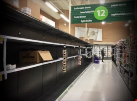
No More Toilet Paper
https://search.heritageburnaby.ca/link/archivedescription95092
- Repository
- City of Burnaby Archives
- Date
- March 14, 2020
- Collection/Fonds
- Burnaby Photographic Society fonds
- Description Level
- Item
- Physical Description
- 1 photograph (tiff)
- Scope and Content
- Photograph of bare shelves in the bathroom tissue aisle of Save-On-Foods at the Market Crossing Shopping Centre in Burnaby.
- Repository
- City of Burnaby Archives
- Date
- March 14, 2020
- Collection/Fonds
- Burnaby Photographic Society fonds
- Physical Description
- 1 photograph (tiff)
- Description Level
- Item
- Record No.
- 623-011
- Access Restriction
- No restrictions
- Reproduction Restriction
- Reproduce for fair dealing purposes only
- Accession Number
- 2020-10
- Scope and Content
- Photograph of bare shelves in the bathroom tissue aisle of Save-On-Foods at the Market Crossing Shopping Centre in Burnaby.
- Media Type
- Photograph
- Photographer
- Asbia, Cher
- Notes
- Transcribed title
- Geographic Access
- Market Crossing
- Marine Way
- Historic Neighbourhood
- Fraser Arm (Historic Neighbourhood)
- Planning Study Area
- Big Bend Area
Images


One person per household
https://search.heritageburnaby.ca/link/archivedescription95109
- Repository
- City of Burnaby Archives
- Date
- April 27, 2020
- Collection/Fonds
- Burnaby Photographic Society fonds
- Description Level
- Item
- Physical Description
- 1 photograph (tiff)
- Scope and Content
- Photograph of the entrance at Save-On-Foods grocery store. One of the two doors at the entrance is blocked by a freestanding sign that reads: "To prevent the spread of COVID-19 Limit 1 person per household". Next to the sign is a shopping cart with signage attached to it informing shoppers that r…
- Repository
- City of Burnaby Archives
- Date
- April 27, 2020
- Collection/Fonds
- Burnaby Photographic Society fonds
- Physical Description
- 1 photograph (tiff)
- Description Level
- Item
- Record No.
- 623-027
- Access Restriction
- No restrictions
- Reproduction Restriction
- No restrictions
- Accession Number
- 2020-10
- Scope and Content
- Photograph of the entrance at Save-On-Foods grocery store. One of the two doors at the entrance is blocked by a freestanding sign that reads: "To prevent the spread of COVID-19 Limit 1 person per household". Next to the sign is a shopping cart with signage attached to it informing shoppers that reusable and cloth bags are prohibited in the store.
- Media Type
- Photograph
- Photographer
- Snowdon, Nick
- Notes
- Transcribed title
- Photographer's caption: "Early on in the pandemic, stores limit number of people from one household. This does not last very long."
- Geographic Access
- Kingsway
- Street Address
- 4429 Kingsway
- Historic Neighbourhood
- Central Park (Historic Neighbourhood)
- Planning Study Area
- Garden Village Area
Images


One way only
https://search.heritageburnaby.ca/link/archivedescription95108
- Repository
- City of Burnaby Archives
- Date
- April 27, 2020
- Collection/Fonds
- Burnaby Photographic Society fonds
- Description Level
- Item
- Physical Description
- 1 photograph (tiff)
- Scope and Content
- Photograph of the baking aisle in Save-On-Foods grocery store. A large red decal on the floor reads "STOP please enter aisle from other end".
- Repository
- City of Burnaby Archives
- Date
- April 27, 2020
- Collection/Fonds
- Burnaby Photographic Society fonds
- Physical Description
- 1 photograph (tiff)
- Description Level
- Item
- Record No.
- 623-026
- Access Restriction
- No restrictions
- Reproduction Restriction
- No restrictions
- Accession Number
- 2020-10
- Scope and Content
- Photograph of the baking aisle in Save-On-Foods grocery store. A large red decal on the floor reads "STOP please enter aisle from other end".
- Media Type
- Photograph
- Photographer
- Snowdon, Nick
- Notes
- Transcribed title
- Photographer's caption: "One way system imposed in store. Not everyone obeys"
- Geographic Access
- Kingsway
- Street Address
- 4429 Kingsway
- Historic Neighbourhood
- Central Park (Historic Neighbourhood)
- Planning Study Area
- Garden Village Area
Images


Social Distancing
https://search.heritageburnaby.ca/link/archivedescription95128
- Repository
- City of Burnaby Archives
- Date
- April 10, 2020
- Collection/Fonds
- Burnaby Photographic Society fonds
- Description Level
- Item
- Physical Description
- 1 photograph (tiff)
- Scope and Content
- Photograph of customers lining up outside Sungiven Foods on East Hastings Street for its grand opening. Customers are standing apart from one another, spaced by red markings on the pavement. Most customers are wearing face masks and looking at their cellphones.
- Repository
- City of Burnaby Archives
- Date
- April 10, 2020
- Collection/Fonds
- Burnaby Photographic Society fonds
- Physical Description
- 1 photograph (tiff)
- Description Level
- Item
- Record No.
- 623-046
- Access Restriction
- No restrictions
- Reproduction Restriction
- Reproduce for fair dealing purposes only
- Accession Number
- 2020-10
- Scope and Content
- Photograph of customers lining up outside Sungiven Foods on East Hastings Street for its grand opening. Customers are standing apart from one another, spaced by red markings on the pavement. Most customers are wearing face masks and looking at their cellphones.
- Media Type
- Photograph
- Photographer
- Jerome, Ron
- Notes
- Transcribed title
- Geographic Access
- Hastings Street
- Street Address
- 4106 Hastings Street
- Historic Neighbourhood
- Vancouver Heights (Historic Neighbourhood)
- Planning Study Area
- Willingdon Heights Area
Images
