Narrow Results By
Subject
- Advertising Medium - Signs and Signboards 6
- Aerial Photographs 5
- Agriculture - Fruit and Berries 1
- Arts - Paintings 1
- Arts - Sculptures 1
- Buildings - Civic 1
- Buildings - Civic - Libraries 1
- Buildings - Commercial 3
- Buildings - Commercial - Automobile Dealerships 1
- Buildings - Commercial - Bakeries 1
- Buildings - Commercial - Grocery Stores 4
- Buildings - Commercial - Restaurants 1
Person / Organization
- Albright, Doris 1
- Arlington's Market 1
- British Columbia Electric Railway Company 1
- British Columbia Hydro and Power Authority 2
- Brown, Charles B. "Charlie" 1
- Burnaby Historical Society 1
- Burnaby Kingsway Rotary Club 1
- Burnaby Public Library 1
- Burnaby South High School 4
- Clark, Mary 1
- Dueck Middlegate 1
- Edmonds Community School 1

Burnaby South High School
https://search.heritageburnaby.ca/link/landmark770
- Repository
- Burnaby Heritage Planning
- Associated Dates
- 1922-1988
- Street View URL
- Google Maps Street View
- Repository
- Burnaby Heritage Planning
- Geographic Access
- Southoaks Crescent
- Associated Dates
- 1922-1988
- Heritage Value
- Burnaby South and Burnaby North were Burnaby's first high schools. The first rooms of the school were built in 1922 on the same grounds as the Kingsway East Elementary School. In 1940, a two-storey building was erected and additions were made in 1963, 1967 and 1972. Kingsway East closed in 1925 and its buildings were used by the high school for Industrial Arts and Home Economics. In the early 1990s, a new "urban education centre" (Burnaby South/B.C. School for the Deaf) was opened, replacing the old Burnaby South High School.
- Historic Neighbourhood
- Edmonds (Historic Neighbourhood)
- Planning Study Area
- Kingsway-Beresford Area
- Street Address
- 6650 Southoaks Crescent
- Street View URL
- Google Maps Street View
Images


Edmonds Street Neighbourhood
https://search.heritageburnaby.ca/link/landmark827
- Repository
- Burnaby Heritage Planning
- Associated Dates
- 1955-2008
- Heritage Value
- The Edmonds Street Neighbourhood is part of the larger Edmonds Town Centre - one of four Town Centres in Burnaby. This neighbourhood is considered to be primarily residential, but a strong local commercial component developed along Edmonds and Kingsway.
- Historic Neighbourhood
- Edmonds (Historic Neighbourhood)
- Planning Study Area
- Edmonds Area
Images


Kingsway-Beresford Neighbourhood
https://search.heritageburnaby.ca/link/landmark805
- Repository
- Burnaby Heritage Planning
- Associated Dates
- 1955-2008
- Heritage Value
- Since the building boom of the 1950s, the Kingsway-Beresford Neighbourhood has maintained a residential character with the exception of the Kingsway corridor, which has become a primary commercial and light industrial sector.
- Historic Neighbourhood
- Edmonds (Historic Neighbourhood)
- Planning Study Area
- Kingsway-Beresford Area
Images


Richmond Park Neighbourhood
https://search.heritageburnaby.ca/link/landmark828
- Repository
- Burnaby Heritage Planning
- Associated Dates
- 1955-2008
- Heritage Value
- The Richmond Park Neighbourhood is part of the larger Edmonds Town Centre - one of four official Town Centres in the City. Richmond Park contains a residential subdivision that developed during the 1950s as well as a strong commercial and retail centre along Edmonds and Kingsway.
- Historic Neighbourhood
- Edmonds (Historic Neighbourhood)
- Planning Study Area
- Richmond Park Area
Images


Stride Avenue Neighbourhood
https://search.heritageburnaby.ca/link/landmark845
- Repository
- Burnaby Heritage Planning
- Associated Dates
- 1955-2008
- Heritage Value
- The interurban link between New Westminster and Vancouver stimulated the early settlement of Stride Avenue. Infilling of the area took place in the early 1950s and the pace of development had slowed considerably by 1970. Duplexes became a popular feature in the decade between 1970 and 1980 and in the late 1980s, the neighbourhood was incorporated into the Edmonds Town Centre South plan.
- Historic Neighbourhood
- Edmonds (Historic Neighbourhood)
- Planning Study Area
- Stride Avenue Area
Images


Stride Hill Neighbourhood
https://search.heritageburnaby.ca/link/landmark846
- Repository
- Burnaby Heritage Planning
- Associated Dates
- 1955-2008
- Heritage Value
- The residential areas that are located within the Stride Hill Neighbourhood were primarily developed in the 1950s during Burnaby's post-war building boom. The area lying to the south of Byrne Creek Ravine Park was used as a municipal garbage dump until the 1960s and as a landfill site for yard waste disposal until the early 1990s at which point the area was incorporated into the Edmonds Town Centre Plan and the land was made into park and open space.
- Historic Neighbourhood
- Edmonds (Historic Neighbourhood)
- Planning Study Area
- Stride Hill Area
Images


Apartment at Gilley and Kingsway
https://search.heritageburnaby.ca/link/archivedescription79023
- Repository
- City of Burnaby Archives
- Date
- October 14, 1976
- Collection/Fonds
- Burnaby Public Library Contemporary Visual Archive Project
- Description Level
- Item
- Physical Description
- 1 photograph : b&w ; 11 x 16 cm mounted on cardboard
- Scope and Content
- Photograph shows apartment building located at the northeast corner of Gilley Avenue and Kingsway.
- Repository
- City of Burnaby Archives
- Date
- October 14, 1976
- Collection/Fonds
- Burnaby Public Library Contemporary Visual Archive Project
- Physical Description
- 1 photograph : b&w ; 11 x 16 cm mounted on cardboard
- Description Level
- Item
- Record No.
- 556-097
- Access Restriction
- No restrictions
- Reproduction Restriction
- Reproduce for fair dealing purposes only
- Accession Number
- 2013-13
- Scope and Content
- Photograph shows apartment building located at the northeast corner of Gilley Avenue and Kingsway.
- Subjects
- Buildings - Residential - Apartments
- Media Type
- Photograph
- Photographer
- Norton, Paul
- Notes
- Scope note taken directly from BPL photograph description.
- 1 b&w copy negative : 10 x 12.5 cm accompanying
- Geographic Access
- Kingsway
- Gilley Avenue
- Street Address
- 6355 Kingsway
- Historic Neighbourhood
- Edmonds (Historic Neighbourhood)
- Planning Study Area
- Kingsway-Beresford Area
Images

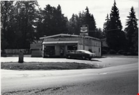
Arlington's Market
https://search.heritageburnaby.ca/link/archivedescription79094
- Repository
- City of Burnaby Archives
- Date
- September 7, 1976
- Collection/Fonds
- Burnaby Public Library Contemporary Visual Archive Project
- Description Level
- Item
- Physical Description
- 1 photograph : b&w ; 11 x 16 cm mounted on cardboard
- Scope and Content
- Photograph shows an unidentified woman coming out of Arlington's Market at 5962 Sperling Avenue near Walker Avenue.
- Repository
- City of Burnaby Archives
- Date
- September 7, 1976
- Collection/Fonds
- Burnaby Public Library Contemporary Visual Archive Project
- Physical Description
- 1 photograph : b&w ; 11 x 16 cm mounted on cardboard
- Description Level
- Item
- Record No.
- 556-148
- Access Restriction
- No restrictions
- Reproduction Restriction
- Reproduce for fair dealing purposes only
- Accession Number
- 2013-13
- Scope and Content
- Photograph shows an unidentified woman coming out of Arlington's Market at 5962 Sperling Avenue near Walker Avenue.
- Names
- Arlington's Market
- Media Type
- Photograph
- Photographer
- Born, A. J.
- Notes
- Scope note taken directly from BPL photograph description.
- 1 b&w copy negative : 10 x 12.5 cm accompanying
- Geographic Access
- Sperling Avenue
- Street Address
- 5962 Sperling Avenue
- Historic Neighbourhood
- Edmonds (Historic Neighbourhood)
- Planning Study Area
- Kingsway-Beresford Area
Images

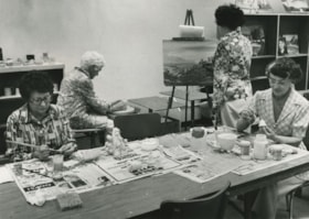
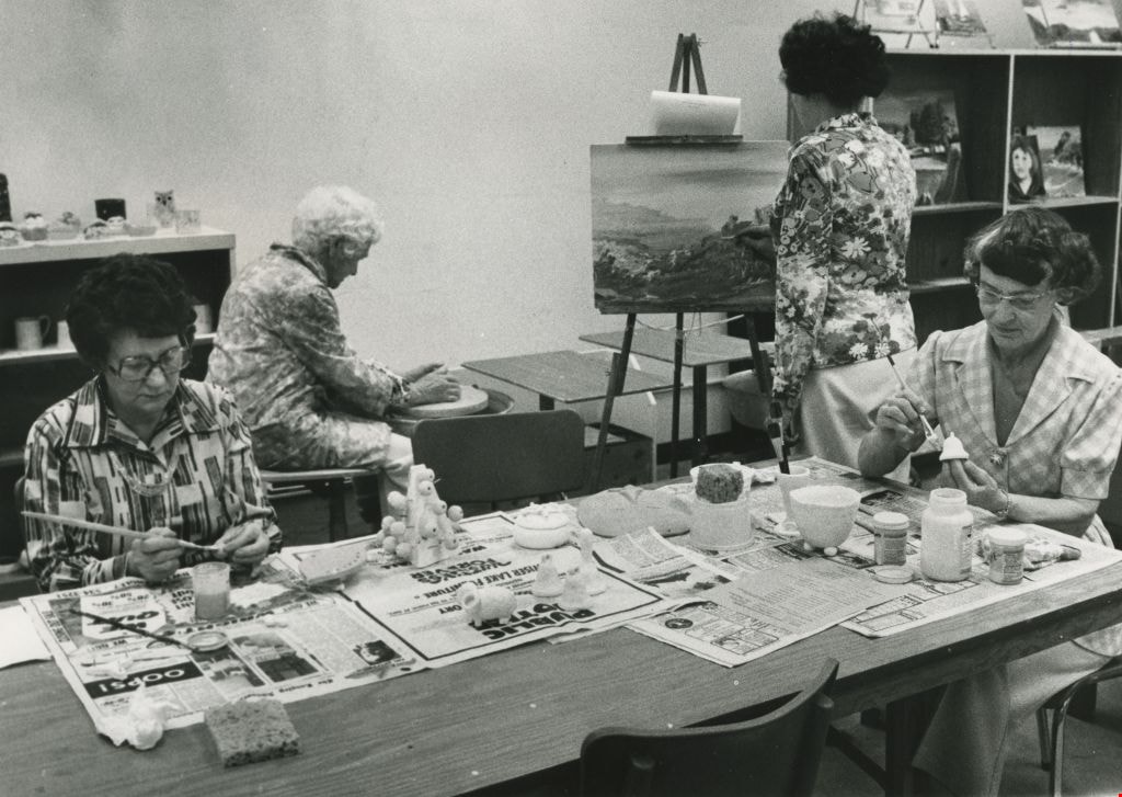
Arts and crafts
https://search.heritageburnaby.ca/link/archivedescription45984
- Repository
- City of Burnaby Archives
- Date
- June 10, 1979
- Collection/Fonds
- Columbian Newspaper collection
- Description Level
- Item
- Physical Description
- 1 photograph : b&w ; 17 x 24 cm
- Scope and Content
- Photograph of women doing arts and crafts at Edmonds House. Marion Olson and Verda Joynt are at a table glazing pottery, while May Clark sits behind them, throwing something on the wheel as Doris Albright stands, painting at an easel. This most likely the site of what is now Edmonds Centre.
- Repository
- City of Burnaby Archives
- Date
- June 10, 1979
- Collection/Fonds
- Columbian Newspaper collection
- Physical Description
- 1 photograph : b&w ; 17 x 24 cm
- Description Level
- Item
- Record No.
- 480-879
- Access Restriction
- No restrictions
- Reproduction Restriction
- Reproduce for fair dealing purposes only
- Accession Number
- 2003-02
- Scope and Content
- Photograph of women doing arts and crafts at Edmonds House. Marion Olson and Verda Joynt are at a table glazing pottery, while May Clark sits behind them, throwing something on the wheel as Doris Albright stands, painting at an easel. This most likely the site of what is now Edmonds Centre.
- Media Type
- Photograph
- Photographer
- Hodge, Craig
- Notes
- Title based on contents of photograph
- Geographic Access
- Kingsway
- Street Address
- 7282 Kingsway
- Historic Neighbourhood
- Edmonds (Historic Neighbourhood)
- Planning Study Area
- Richmond Park Area
Images
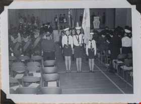
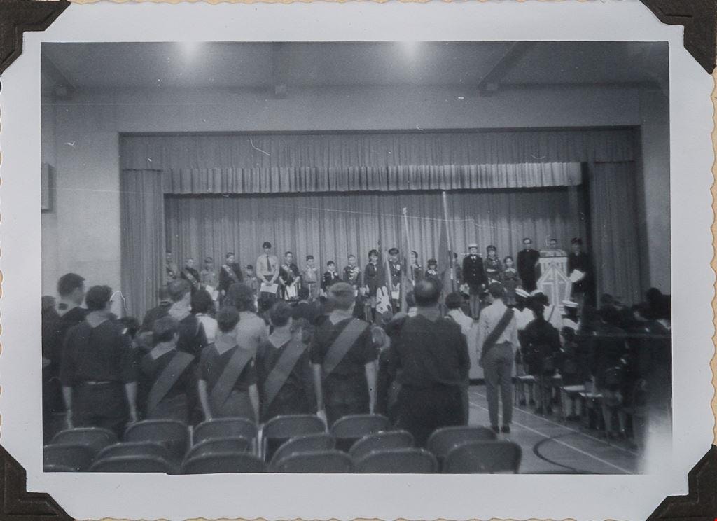
Baden Powell Sunday - honour guard
https://search.heritageburnaby.ca/link/museumdescription4964
- Repository
- Burnaby Village Museum
- Date
- Feb 22, 1970
- Collection/Fonds
- Burnaby Girl Guides fonds
- Description Level
- Item
- Physical Description
- 1 photograph : b&w ; 11.5 x 8 cm
- Scope and Content
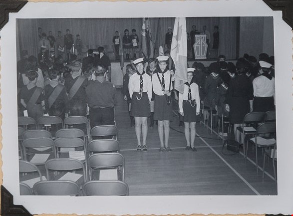
- Photograph of the honour guard standing at attention during the "Baden Powell Sunday" event which took place at Burnaby South High School. Three Sea Rangers are dressed in uniforms with the one in the centre holding a Canadian Flag. Two members of the 51st Brownies are standing behind the Rangers a…
- Repository
- Burnaby Village Museum
- Collection/Fonds
- Burnaby Girl Guides fonds
- Description Level
- Item
- Physical Description
- 1 photograph : b&w ; 11.5 x 8 cm
- Scope and Content
- Photograph of the honour guard standing at attention during the "Baden Powell Sunday" event which took place at Burnaby South High School. Three Sea Rangers are dressed in uniforms with the one in the centre holding a Canadian Flag. Two members of the 51st Brownies are standing behind the Rangers and are holding the Guide flag.
- Geographic Access
- Southoaks Crescent
- Street Address
- 6650 Southoaks Crescent
- Accession Code
- BV016.49.106
- Access Restriction
- No restrictions
- Reproduction Restriction
- May be restricted by third party rights
- Date
- Feb 22, 1970
- Media Type
- Photograph
- Historic Neighbourhood
- Edmonds (Historic Neighbourhood)
- Planning Study Area
- Kingsway-Beresford Area
- Scan Resolution
- 600
- Scan Date
- 05/11/2018
- Scale
- 100
- Notes
- Title based on content of photograph
- Note in black ink next to photograph reads: "Back there are two / 51st Brownies as the / honour guard for the Guide flag"
- Photographs are part of scrapbook BV016.49.81
Images
Badon Powell Sunday
https://search.heritageburnaby.ca/link/museumdescription4962
- Repository
- Burnaby Village Museum
- Date
- Feb 22, 1970
- Collection/Fonds
- Burnaby Girl Guides fonds
- Description Level
- Item
- Physical Description
- 1 photograph : b&w ; 11.5 x 8 cm
- Scope and Content
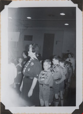
- Photograph of members of the 51st Burnaby Brownie Pack with Scouts, leaders and other guides for the "Baden Powell Sunday" event which took place at Burnaby South High School. The 51st Brownies are on the far left of the photograph.
- Repository
- Burnaby Village Museum
- Collection/Fonds
- Burnaby Girl Guides fonds
- Description Level
- Item
- Physical Description
- 1 photograph : b&w ; 11.5 x 8 cm
- Scope and Content
- Photograph of members of the 51st Burnaby Brownie Pack with Scouts, leaders and other guides for the "Baden Powell Sunday" event which took place at Burnaby South High School. The 51st Brownies are on the far left of the photograph.
- Geographic Access
- Southoaks Crescent
- Street Address
- 6650 Southoaks Crescent
- Accession Code
- BV016.49.104
- Access Restriction
- No restrictions
- Reproduction Restriction
- May be restricted by third party rights
- Date
- Feb 22, 1970
- Media Type
- Photograph
- Historic Neighbourhood
- Edmonds (Historic Neighbourhood)
- Planning Study Area
- Kingsway-Beresford Area
- Scan Resolution
- 600
- Scan Date
- 05/11/2018
- Notes
- Title based on content of photograph
- Note in black ink to the right of the photograph reads: "Badon - Powell Sunday" / "Feb. 22nd, 1970 / Burnaby South High / School". "Those are 51st Brownies / (on the far side)"
- Photograph is part of scrapbook BV016.49.81
Images
Badon Powell Sunday
https://search.heritageburnaby.ca/link/museumdescription4963
- Repository
- Burnaby Village Museum
- Date
- Feb 22, 1970
- Collection/Fonds
- Burnaby Girl Guides fonds
- Description Level
- Item
- Physical Description
- 1 photograph : b&w ; 11.5 x 8 cm
- Scope and Content
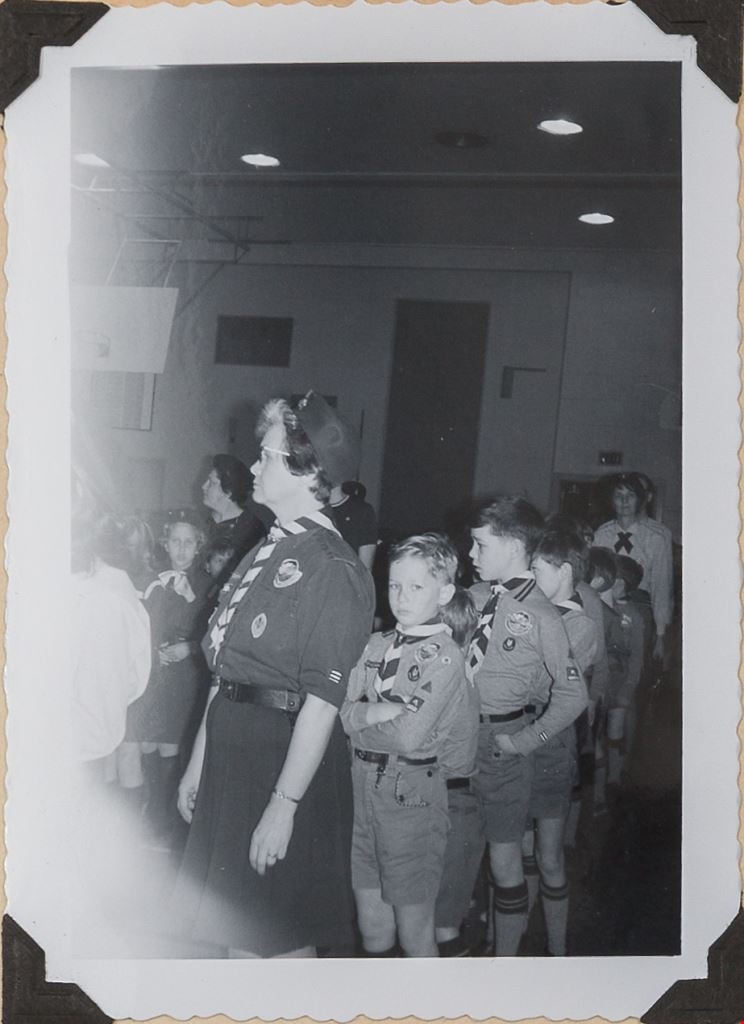
- Photograph of members of the 51st Burnaby Brownie Pack with Scouts, leaders and other guides for the "Baden Powell Sunday" event which took place at Burnaby South High School. Special guests are standing on the stage while the rest of the Girl Guides and Scouts look on from the audience. Father D. …
- Repository
- Burnaby Village Museum
- Collection/Fonds
- Burnaby Girl Guides fonds
- Description Level
- Item
- Physical Description
- 1 photograph : b&w ; 11.5 x 8 cm
- Scope and Content
- Photograph of members of the 51st Burnaby Brownie Pack with Scouts, leaders and other guides for the "Baden Powell Sunday" event which took place at Burnaby South High School. Special guests are standing on the stage while the rest of the Girl Guides and Scouts look on from the audience. Father D. Monroe was the officiating clergyman at the ceremony.
- Geographic Access
- Southoaks Crescent
- Street Address
- 6650 Southoaks Crescent
- Accession Code
- BV016.49.105
- Access Restriction
- No restrictions
- Reproduction Restriction
- May be restricted by third party rights
- Date
- Feb 22, 1970
- Media Type
- Photograph
- Historic Neighbourhood
- Edmonds (Historic Neighbourhood)
- Planning Study Area
- Kingsway-Beresford Area
- Scan Resolution
- 600
- Scan Date
- 05/11/2018
- Scale
- 100
- Notes
- Title based on content of photograph
- Note in black ink next to photograph reads: "Fr. D. Monroe was the / officiating clergyman"
- Photograph is part of scrapbook BV016.49.81
Images
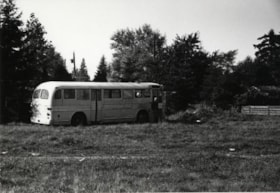
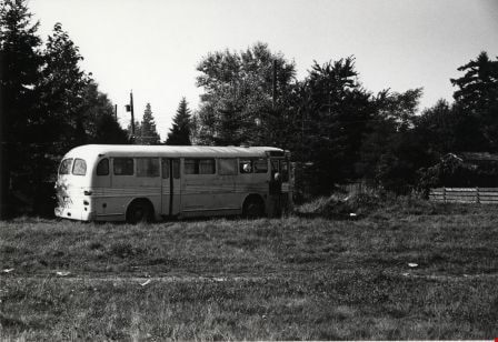
BC Hydro Bus
https://search.heritageburnaby.ca/link/archivedescription79688
- Repository
- City of Burnaby Archives
- Date
- September 24, 1976
- Collection/Fonds
- Burnaby Public Library Contemporary Visual Archive Project
- Description Level
- Item
- Physical Description
- 1 photograph : b&w ; 11 x 16 cm mounted on cardboard
- Scope and Content
- Photograph shows an old B.C. Hydro Bus, being converted into a motor home, sitting in the yard of 6732 Imperial Street.
- Repository
- City of Burnaby Archives
- Date
- September 24, 1976
- Collection/Fonds
- Burnaby Public Library Contemporary Visual Archive Project
- Physical Description
- 1 photograph : b&w ; 11 x 16 cm mounted on cardboard
- Description Level
- Item
- Record No.
- 556-384
- Access Restriction
- No restrictions
- Reproduction Restriction
- Reproduce for fair dealing purposes only
- Accession Number
- 2013-13
- Scope and Content
- Photograph shows an old B.C. Hydro Bus, being converted into a motor home, sitting in the yard of 6732 Imperial Street.
- Subjects
- Transportation - Buses
- Media Type
- Photograph
- Photographer
- Born, A. J.
- Notes
- Scope note taken directly from BPL photograph description.
- 1 b&w copy negative : 10 x 12.5 cm accompanying
- Geographic Access
- Imperial Street
- Street Address
- 6732 Imperial Street
- Historic Neighbourhood
- Edmonds (Historic Neighbourhood)
- Planning Study Area
- Kingsway-Beresford Area
Images

BC Hydro Railway Crossing
https://search.heritageburnaby.ca/link/archivedescription79487
- Repository
- City of Burnaby Archives
- Date
- September 22, 1976
- Collection/Fonds
- Burnaby Public Library Contemporary Visual Archive Project
- Description Level
- Item
- Physical Description
- 1 photograph : b&w ; 11 x 16 cm mounted on cardboard
- Scope and Content
- Photograph shows BC Hydro railroad tracks and crossing near Beresford Street and Griffiths Avenue.
- Repository
- City of Burnaby Archives
- Date
- September 22, 1976
- Collection/Fonds
- Burnaby Public Library Contemporary Visual Archive Project
- Physical Description
- 1 photograph : b&w ; 11 x 16 cm mounted on cardboard
- Description Level
- Item
- Record No.
- 556-319
- Access Restriction
- No restrictions
- Reproduction Restriction
- Reproduce for fair dealing purposes only
- Accession Number
- 2013-13
- Scope and Content
- Photograph shows BC Hydro railroad tracks and crossing near Beresford Street and Griffiths Avenue.
- Media Type
- Photograph
- Photographer
- Ross, Martha
- Notes
- Scope note taken directly from BPL photograph description.
- 1 b&w copy negative : 10 x 12.5 cm accompanying
- Historic Neighbourhood
- Edmonds (Historic Neighbourhood)
- Planning Study Area
- Stride Avenue Area
Images

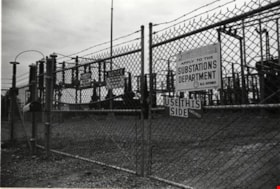
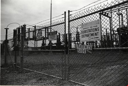
BC Hydro Substation
https://search.heritageburnaby.ca/link/archivedescription79356
- Repository
- City of Burnaby Archives
- Date
- September 22, 1976
- Collection/Fonds
- Burnaby Public Library Contemporary Visual Archive Project
- Description Level
- Item
- Physical Description
- 1 photograph : b&w ; 11 x 16 cm mounted on cardboard
- Scope and Content
- Photograph shows a BC Hydro substation located in Powerhouse Park near Beresford Street and Griffiths Avenue.
- Repository
- City of Burnaby Archives
- Date
- September 22, 1976
- Collection/Fonds
- Burnaby Public Library Contemporary Visual Archive Project
- Physical Description
- 1 photograph : b&w ; 11 x 16 cm mounted on cardboard
- Description Level
- Item
- Record No.
- 556-263
- Access Restriction
- No restrictions
- Reproduction Restriction
- Reproduce for fair dealing purposes only
- Accession Number
- 2013-13
- Scope and Content
- Photograph shows a BC Hydro substation located in Powerhouse Park near Beresford Street and Griffiths Avenue.
- Media Type
- Photograph
- Photographer
- Ross, Martha
- Notes
- Scope note taken directly from BPL photograph description.
- 1 b&w copy negative : 10 x 12.5 cm accompanying
- Geographic Access
- Griffiths Avenue
- Beresford Street
- Street Address
- 6970 Beresford Street
- Historic Neighbourhood
- Edmonds (Historic Neighbourhood)
- Planning Study Area
- Stride Avenue Area
Images
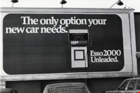
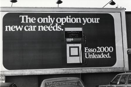
Billboard
https://search.heritageburnaby.ca/link/archivedescription79927
- Repository
- City of Burnaby Archives
- Date
- October 20, 1976
- Collection/Fonds
- Burnaby Public Library Contemporary Visual Archive Project
- Description Level
- Item
- Physical Description
- 1 photograph : b&w ; 11 x 16 cm mounted on cardboard
- Scope and Content
- Photograph shows a large billboard advertising Esso Gas in a parking lot off Edmonds, near Kingsway.
- Repository
- City of Burnaby Archives
- Date
- October 20, 1976
- Collection/Fonds
- Burnaby Public Library Contemporary Visual Archive Project
- Physical Description
- 1 photograph : b&w ; 11 x 16 cm mounted on cardboard
- Description Level
- Item
- Record No.
- 556-498
- Access Restriction
- No restrictions
- Reproduction Restriction
- Reproduce for fair dealing purposes only
- Accession Number
- 2013-13
- Scope and Content
- Photograph shows a large billboard advertising Esso Gas in a parking lot off Edmonds, near Kingsway.
- Media Type
- Photograph
- Photographer
- Ross, Martha
- Notes
- Scope note taken directly from BPL photograph description.
- 1 b&w copy negative : 10 x 12.5 cm accompanying
- Historic Neighbourhood
- Edmonds (Historic Neighbourhood)
Images
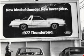
Billboard
https://search.heritageburnaby.ca/link/archivedescription79928
- Repository
- City of Burnaby Archives
- Date
- October 20, 1976
- Collection/Fonds
- Burnaby Public Library Contemporary Visual Archive Project
- Description Level
- Item
- Physical Description
- 1 photograph : b&w ; 11 x 16 cm mounted on cardboard
- Scope and Content
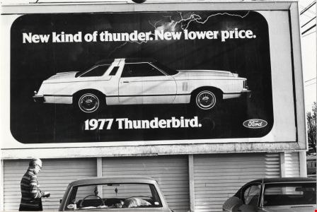
- Photograph shows a large billboard advertising the 1977 Thunderbird car. The sign is attached to the side of a building in a parking lot on Edmonds Street near Kingsway.
- Repository
- City of Burnaby Archives
- Date
- October 20, 1976
- Collection/Fonds
- Burnaby Public Library Contemporary Visual Archive Project
- Physical Description
- 1 photograph : b&w ; 11 x 16 cm mounted on cardboard
- Description Level
- Item
- Record No.
- 556-499
- Access Restriction
- No restrictions
- Reproduction Restriction
- Reproduce for fair dealing purposes only
- Accession Number
- 2013-13
- Scope and Content
- Photograph shows a large billboard advertising the 1977 Thunderbird car. The sign is attached to the side of a building in a parking lot on Edmonds Street near Kingsway.
- Media Type
- Photograph
- Photographer
- Ross, Martha
- Notes
- Scope note taken directly from BPL photograph description.
- 1 b&w copy negative : 10 x 12.5 cm accompanying
- Historic Neighbourhood
- Edmonds (Historic Neighbourhood)
Images

Burnaby's Operation Identification
https://search.heritageburnaby.ca/link/archivedescription45330
- Repository
- City of Burnaby Archives
- Date
- 1976, published January 7, 1976
- Collection/Fonds
- Columbian Newspaper collection
- Description Level
- Item
- Physical Description
- 1 photograph : b&w ; 22.5 x 14.5 cm
- Scope and Content
- Photograph of municipal workers Bill Ramsay and Greg Finch putting up a sign in preparation for Burnaby's Operation Identification, which was "the largest single crime prevention policy of its kind in Canada" when "47 uniformed officers of the Burnaby detachment [joined] 47 Rotarians from the Burna…
- Repository
- City of Burnaby Archives
- Date
- 1976, published January 7, 1976
- Collection/Fonds
- Columbian Newspaper collection
- Physical Description
- 1 photograph : b&w ; 22.5 x 14.5 cm
- Description Level
- Item
- Record No.
- 480-225
- Access Restriction
- No restrictions
- Reproduction Restriction
- No restrictions
- Accession Number
- 2003-02
- Scope and Content
- Photograph of municipal workers Bill Ramsay and Greg Finch putting up a sign in preparation for Burnaby's Operation Identification, which was "the largest single crime prevention policy of its kind in Canada" when "47 uniformed officers of the Burnaby detachment [joined] 47 Rotarians from the Burnaby Kingsway Rotary Club and start door-to-door visits in 800 residences in South Burnaby. The teams [carried] electric engraving pens for marking all property susceptible to theft."
- Media Type
- Photograph
- Photographer
- King, Basil
- Notes
- Title based on contents of photograph
- Newspaper clipping attached to verso of photograph reads: "Burnaby detachment of the RCMP has embarked on the largest single crime prevention policy of its kind in Canada. "Operation Identification" officially kicks off tonight when 47 uniformed officers of the Burnaby detachment will join with 47 Rotarians from the Burnaby Kingsway Rotary Club and start door-to-door visits in 800 residences in South Burnaby. The teams will be carrying electric engraving pens for marking all property susceptible to theft. Municipal workers Bill Ramsay and Greg Finch are shown erecting one of the signs on Canada Way at 14th Avenue as "sidewalk superintendents" Sandra Finch and Corinne Williams look on."
- Geographic Access
- Canada Way
- 14th Avenue
- Historic Neighbourhood
- Edmonds (Historic Neighbourhood)
- Planning Study Area
- Edmonds Area
Images

Burnaby South Senior Secondary School
https://search.heritageburnaby.ca/link/archivedescription79668
- Repository
- City of Burnaby Archives
- Date
- September 23, 1976
- Collection/Fonds
- Burnaby Public Library Contemporary Visual Archive Project
- Description Level
- Item
- Physical Description
- 1 photograph : b&w ; 11 x 16 cm mounted on cardboard
- Scope and Content
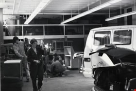
- Photograph shows industrial education class in Burnaby South Senior Secondary School at 6626 Kingsway.
- Repository
- City of Burnaby Archives
- Date
- September 23, 1976
- Collection/Fonds
- Burnaby Public Library Contemporary Visual Archive Project
- Physical Description
- 1 photograph : b&w ; 11 x 16 cm mounted on cardboard
- Description Level
- Item
- Record No.
- 556-369
- Access Restriction
- No restrictions
- Reproduction Restriction
- Reproduce for fair dealing purposes only
- Accession Number
- 2013-13
- Scope and Content
- Photograph shows industrial education class in Burnaby South Senior Secondary School at 6626 Kingsway.
- Subjects
- Buildings - Schools
- Media Type
- Photograph
- Photographer
- Ross, Martha
- Notes
- Scope note taken directly from BPL photograph description.
- 1 b&w copy negative : 10 x 12.5 cm accompanying
- Geographic Access
- Kingsway
- Southoaks Crescent
- Street Address
- 6626 Kingsway
- 6650 Southoaks Crescent
- Historic Neighbourhood
- Edmonds (Historic Neighbourhood)
- Planning Study Area
- Kingsway-Beresford Area
Images


Buses parked near Kingsway
https://search.heritageburnaby.ca/link/archivedescription79484
- Repository
- City of Burnaby Archives
- Date
- October 7, 1976
- Collection/Fonds
- Burnaby Public Library Contemporary Visual Archive Project
- Description Level
- Item
- Physical Description
- 1 photograph : b&w ; 11 x 16 cm mounted on cardboard
- Scope and Content
- Photograph shows buses parked beneath gasoline billboard just off Kingsway near 13th Avenue.
- Repository
- City of Burnaby Archives
- Date
- October 7, 1976
- Collection/Fonds
- Burnaby Public Library Contemporary Visual Archive Project
- Physical Description
- 1 photograph : b&w ; 11 x 16 cm mounted on cardboard
- Description Level
- Item
- Record No.
- 556-316
- Access Restriction
- No restrictions
- Reproduction Restriction
- Reproduce for fair dealing purposes only
- Accession Number
- 2013-13
- Scope and Content
- Photograph shows buses parked beneath gasoline billboard just off Kingsway near 13th Avenue.
- Media Type
- Photograph
- Photographer
- Born, A. J.
- Notes
- Scope note taken directly from BPL photograph description.
- 1 b&w copy negative : 10 x 12.5 cm accompanying
- Geographic Access
- Kingsway
- 13th Avenue
- Historic Neighbourhood
- Edmonds (Historic Neighbourhood)
- Planning Study Area
- Stride Avenue Area
Images
