Narrow Results By
Subject
- Advertising Medium 2
- Advertising Medium - Signs and Signboards 1
- Agriculture - Fruit and Berries 1
- Buildings - Civic 1
- Buildings - Civic - City Halls 14
- Buildings - Commercial 2
- Buildings - Commercial - Banks 3
- Buildings - Commercial - Hotels and Motels 4
- Buildings - Commercial - Restaurants 1
- Buildings - Industrial 2
- Buildings - Recreational 4
- Buildings - Religious - Churches 2
Person / Organization
- Beamish, William Randolph "Ran" 5
- Blue Haven Motel 1
- Brown, Charles B. "Charlie" 1
- Brown, Clifton Gilbert, 1889-1960 2
- Brown, Lillian Bernice Bryan "Bernie" 1
- Burnaby Central Secondary School 1
- Burnaby City Hall 16
- Burnaby Orchids Limited 2
- Burnaby South High School 6
- Charlton, Gerald 2
- Coutts, Lois Hollands 1
- Coutts, Stewart "Stu" 1

Burnaby South High School
https://search.heritageburnaby.ca/link/landmark770
- Repository
- Burnaby Heritage Planning
- Associated Dates
- 1922-1988
- Street View URL
- Google Maps Street View
- Repository
- Burnaby Heritage Planning
- Geographic Access
- Southoaks Crescent
- Associated Dates
- 1922-1988
- Heritage Value
- Burnaby South and Burnaby North were Burnaby's first high schools. The first rooms of the school were built in 1922 on the same grounds as the Kingsway East Elementary School. In 1940, a two-storey building was erected and additions were made in 1963, 1967 and 1972. Kingsway East closed in 1925 and its buildings were used by the high school for Industrial Arts and Home Economics. In the early 1990s, a new "urban education centre" (Burnaby South/B.C. School for the Deaf) was opened, replacing the old Burnaby South High School.
- Historic Neighbourhood
- Edmonds (Historic Neighbourhood)
- Planning Study Area
- Kingsway-Beresford Area
- Street Address
- 6650 Southoaks Crescent
- Street View URL
- Google Maps Street View
Images


East Burnaby Neighbourhood
https://search.heritageburnaby.ca/link/landmark712
- Repository
- Burnaby Heritage Planning
- Associated Dates
- 1925-1954
- Heritage Value
- After a lull in construction during the World War I period, East Burnaby Neighbourhood's growth resumed during the 1920s when many homes and businesses were constructed. The post-World War Two period also saw rapid construction and the creation of new housing developments in response to a population boom. The neighbourhood remained a primarily single-family residential area.
- Historic Neighbourhood
- Edmonds (Historic Neighbourhood)
- Planning Study Area
- Stride Avenue Area
Images


Edmonds Neighbourhood
https://search.heritageburnaby.ca/link/landmark704
- Repository
- Burnaby Heritage Planning
- Associated Dates
- 1925-1954
- Heritage Value
- The historic growth of Edmonds as a neighbourhood was based on its strategic location on the early interurban line between Vancouver and New Westminster. Even by 1980 when a survey of the residential neighbourhoods was conducted, a full 25% of homes in the area predated 1930. The 1950s was a period of strong housing development, with both single-family and multi-family units being constructed. Although Burnaby's City Hall was moved from Kingsway and Edmonds in the early 1950s, Edmonds remained an important centre in the community.
- Historic Neighbourhood
- Edmonds (Historic Neighbourhood)
- Planning Study Area
- Stride Avenue Area
Images


Edmonds Street Neighbourhood
https://search.heritageburnaby.ca/link/landmark827
- Repository
- Burnaby Heritage Planning
- Associated Dates
- 1955-2008
- Heritage Value
- The Edmonds Street Neighbourhood is part of the larger Edmonds Town Centre - one of four Town Centres in Burnaby. This neighbourhood is considered to be primarily residential, but a strong local commercial component developed along Edmonds and Kingsway.
- Historic Neighbourhood
- Edmonds (Historic Neighbourhood)
- Planning Study Area
- Edmonds Area
Images


Kingsway-Beresford Neighbourhood
https://search.heritageburnaby.ca/link/landmark805
- Repository
- Burnaby Heritage Planning
- Associated Dates
- 1955-2008
- Heritage Value
- Since the building boom of the 1950s, the Kingsway-Beresford Neighbourhood has maintained a residential character with the exception of the Kingsway corridor, which has become a primary commercial and light industrial sector.
- Historic Neighbourhood
- Edmonds (Historic Neighbourhood)
- Planning Study Area
- Kingsway-Beresford Area
Images


Richmond Park Neighbourhood
https://search.heritageburnaby.ca/link/landmark828
- Repository
- Burnaby Heritage Planning
- Associated Dates
- 1955-2008
- Heritage Value
- The Richmond Park Neighbourhood is part of the larger Edmonds Town Centre - one of four official Town Centres in the City. Richmond Park contains a residential subdivision that developed during the 1950s as well as a strong commercial and retail centre along Edmonds and Kingsway.
- Historic Neighbourhood
- Edmonds (Historic Neighbourhood)
- Planning Study Area
- Richmond Park Area
Images


Stride Avenue Neighbourhood
https://search.heritageburnaby.ca/link/landmark845
- Repository
- Burnaby Heritage Planning
- Associated Dates
- 1955-2008
- Heritage Value
- The interurban link between New Westminster and Vancouver stimulated the early settlement of Stride Avenue. Infilling of the area took place in the early 1950s and the pace of development had slowed considerably by 1970. Duplexes became a popular feature in the decade between 1970 and 1980 and in the late 1980s, the neighbourhood was incorporated into the Edmonds Town Centre South plan.
- Historic Neighbourhood
- Edmonds (Historic Neighbourhood)
- Planning Study Area
- Stride Avenue Area
Images


Stride Hill Neighbourhood
https://search.heritageburnaby.ca/link/landmark846
- Repository
- Burnaby Heritage Planning
- Associated Dates
- 1955-2008
- Heritage Value
- The residential areas that are located within the Stride Hill Neighbourhood were primarily developed in the 1950s during Burnaby's post-war building boom. The area lying to the south of Byrne Creek Ravine Park was used as a municipal garbage dump until the 1960s and as a landfill site for yard waste disposal until the early 1990s at which point the area was incorporated into the Edmonds Town Centre Plan and the land was made into park and open space.
- Historic Neighbourhood
- Edmonds (Historic Neighbourhood)
- Planning Study Area
- Stride Hill Area
Images


Twelfth Avenue Elementary School
https://search.heritageburnaby.ca/link/landmark848
- Repository
- Burnaby Heritage Planning
- Geographic Access
- 12th Avenue
- Associated Dates
- 1958
- Heritage Value
- Twelfth Avenue School was one of two schools built to relieve the overcrowding at Edmonds School resulting from the housing boom in Burnaby during the 1950s - Lakeview was the other. Built in 1958, the building was added to in 1962, 1964, 1967, 1969 and 1974.
- Historic Neighbourhood
- Edmonds (Historic Neighbourhood)
- Planning Study Area
- Edmonds Area
- Street Address
- 7622 12th Avenue
- Street View URL
- Google Maps Street View
Images


20th century typewriting : complete course
https://search.heritageburnaby.ca/link/museumlibrary5012
- Repository
- Burnaby Village Museum
- Collection
- Special Collection
- Material Type
- Book
- Accession Code
- BV007.2.1
- Call Number
- 652.3 LES
- Edition
- 6th ed.
- Place of Publication
- Cincinnati
- Publisher
- South-Western Publishing Co.
- Publication Date
- c1952
- Physical Description
- 340 p. : ill. : 20 x 28 cm.
- Library Subject (LOC)
- Typewriting
- Subjects
- Documentary Artifacts - Books
- Historic Neighbourhood
- Edmonds (Historic Neighbourhood)
- Burnaby Lake (Historic Neighbourhood)
- Planning Study Area
- Kingsway-Beresford Area
- Douglas-Gilpin Area
- Geographic Access
- Canada Way
- Southoaks Crescent
- Street Address
- 4939 Canada Way
- 6650 Southoaks Crescent
- Object History
- Was used by Burnaby resident Barbara Copan when she taught typing at Burnaby Central circa 1963-65. It may have originally belonged to Barbara's mother who also taught typing at Burnaby South High School circa 1957 to 1965. She mainly taught typing in night school.
- Notes
- Authors' given name and date as follows: Lessenberry, D.D. (David Daniel), 1896- Crawford, T. James (Thomas James)
Images


![1520 Mary Avenue, [1951] (date of original), copied 1991 thumbnail](/media/hpo/_Data/_Archives_Images/_Unrestricted/370/370-495.jpg?width=280)
1520 Mary Avenue
https://search.heritageburnaby.ca/link/archivedescription37907
- Repository
- City of Burnaby Archives
- Date
- [1951] (date of original), copied 1991
- Collection/Fonds
- Burnaby Historical Society fonds
- Description Level
- Item
- Physical Description
- 1 photograph : b&w ; 2.7 x 4.3 cm print on contact sheet 20.2 x 26.3 cm
- Scope and Content
- Photograph of the front of the house at 1520 Mary Avenue (later renumbered 7537 Mary Avenue).
- Repository
- City of Burnaby Archives
- Date
- [1951] (date of original), copied 1991
- Collection/Fonds
- Burnaby Historical Society fonds
- Subseries
- Burnaby Image Bank subseries
- Physical Description
- 1 photograph : b&w ; 2.7 x 4.3 cm print on contact sheet 20.2 x 26.3 cm
- Description Level
- Item
- Record No.
- 370-495
- Access Restriction
- No restrictions
- Reproduction Restriction
- No restrictions
- Accession Number
- BHS1999-03
- Scope and Content
- Photograph of the front of the house at 1520 Mary Avenue (later renumbered 7537 Mary Avenue).
- Subjects
- Buildings - Residential - Houses
- Media Type
- Photograph
- Notes
- Title based on contents of photograph
- 1 b&w copy negative accompanying
- Negative has a pink cast
- Geographic Access
- Mary Avenue
- Street Address
- 7537 Mary Avenue
- Historic Neighbourhood
- Edmonds (Historic Neighbourhood)
- Planning Study Area
- Edmonds Area
Images
![1520 Mary Avenue, [1951] (date of original), copied 1991 thumbnail](/media/hpo/_Data/_Archives_Images/_Unrestricted/370/370-495.jpg)
![1520 Mary Avenue, [1951] (date of original), copied 1991 thumbnail](/media/hpo/_Data/_Archives_Images/_Unrestricted/370/370-496.jpg?width=280)
1520 Mary Avenue
https://search.heritageburnaby.ca/link/archivedescription37908
- Repository
- City of Burnaby Archives
- Date
- [1951] (date of original), copied 1991
- Collection/Fonds
- Burnaby Historical Society fonds
- Description Level
- Item
- Physical Description
- 1 photograph : b&w ; 2.7 x 4.2 cm print on contact sheet 20.2 x 26.3 cm
- Scope and Content
- Photograph of the rear of the house at 1520 Mary Avenue (later renumbered as 7537 Mary Avenue).
- Repository
- City of Burnaby Archives
- Date
- [1951] (date of original), copied 1991
- Collection/Fonds
- Burnaby Historical Society fonds
- Subseries
- Burnaby Image Bank subseries
- Physical Description
- 1 photograph : b&w ; 2.7 x 4.2 cm print on contact sheet 20.2 x 26.3 cm
- Description Level
- Item
- Record No.
- 370-496
- Access Restriction
- No restrictions
- Reproduction Restriction
- No restrictions
- Accession Number
- BHS1999-03
- Scope and Content
- Photograph of the rear of the house at 1520 Mary Avenue (later renumbered as 7537 Mary Avenue).
- Subjects
- Buildings - Residential - Houses
- Media Type
- Photograph
- Notes
- Title based on contents of photograph
- 1 b&w copy negative accompanying
- Negative has a pink cast
- Geographic Access
- Mary Avenue
- Street Address
- 7537 Mary Avenue
- Historic Neighbourhood
- Edmonds (Historic Neighbourhood)
- Planning Study Area
- Edmonds Area
Images
![1520 Mary Avenue, [1951] (date of original), copied 1991 thumbnail](/media/hpo/_Data/_Archives_Images/_Unrestricted/370/370-496.jpg)
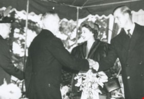
Alice and George Grant meet Princess Elizabeth and the Duke of Edinburgh
https://search.heritageburnaby.ca/link/archivedescription36881
- Repository
- City of Burnaby Archives
- Date
- 1951
- Collection/Fonds
- Burnaby Historical Society fonds
- Description Level
- Item
- Physical Description
- 1 photograph : b&w ; 8.8 x 12.6 cm print
- Scope and Content
- Photograph of Alice and George Grant meeting Princess Elizabeth and the Duke of Edinburgh at Burnaby Municipal Hall.
- Repository
- City of Burnaby Archives
- Date
- 1951
- Collection/Fonds
- Burnaby Historical Society fonds
- Subseries
- Burnaby Centennial Anthology subseries
- Physical Description
- 1 photograph : b&w ; 8.8 x 12.6 cm print
- Description Level
- Item
- Record No.
- 315-339
- Access Restriction
- No restrictions
- Reproduction Restriction
- Reproduce for fair dealing purposes only
- Accession Number
- BHS1994-04
- Scope and Content
- Photograph of Alice and George Grant meeting Princess Elizabeth and the Duke of Edinburgh at Burnaby Municipal Hall.
- Subjects
- Events - Royal Visits
- Names
- Elizabeth II Queen of Great Britain, 1926-2022
- Grant, Alice Taylor
- Grant, George Alford
- Philip, Prince, consort of Elizabeth II, Queen of Great Britain, 1921-
- Media Type
- Photograph
- Notes
- Title based on contents of photograph
- Geographic Access
- Kingsway
- Edmonds Street
- Historic Neighbourhood
- Edmonds (Historic Neighbourhood)
- Planning Study Area
- Stride Avenue Area
Images

At the Gai Paree Supper Club
https://search.heritageburnaby.ca/link/archivedescription66396
- Repository
- City of Burnaby Archives
- Date
- March 6, 1952
- Collection/Fonds
- Grieve family fonds
- Description Level
- Item
- Physical Description
- 1 photograph : b&w ; 9 x 14 cm, mounted in card ; 12.5 x 33.5 cm, folded to 12.5 x 17 cm
- Scope and Content
- Photograph of William Ewart "Bill" Grieve sitting at a table at the Gai Paree Supper Club with Clifford G. Brown. The four other individuals at the table have not been identified.
- Repository
- City of Burnaby Archives
- Date
- March 6, 1952
- Collection/Fonds
- Grieve family fonds
- Physical Description
- 1 photograph : b&w ; 9 x 14 cm, mounted in card ; 12.5 x 33.5 cm, folded to 12.5 x 17 cm
- Description Level
- Item
- Record No.
- 523-010
- Access Restriction
- No restrictions
- Reproduction Restriction
- Reproduce for fair dealing purposes only
- Accession Number
- 2011-04
- Scope and Content
- Photograph of William Ewart "Bill" Grieve sitting at a table at the Gai Paree Supper Club with Clifford G. Brown. The four other individuals at the table have not been identified.
- Subjects
- Events - Parties
- Media Type
- Photograph
- Notes
- Title based on contents of photograph
- Note on recto of card mount reads: "2004 January I believe the Gai Paree has disappeared"
- Notes inside card on recto of photograph mount read: "Maybe wartime?", "Bill Grieve, Chair of Burnaby School Bd circa 1955?" and "Clifford [sic] G. Brown, a school superintendent after whom a Pool named by Burnaby Lake"
- Geographic Access
- Kingsway
- Street Address
- 6669 Kingsway
- Historic Neighbourhood
- Edmonds (Historic Neighbourhood)
- Planning Study Area
- Kingsway-Beresford Area
![Blue Haven Motel, [195-] thumbnail](/media/hpo/_Data/_Archives_Images/_Unrestricted/126/199-001.jpg?width=280)
Blue Haven Motel
https://search.heritageburnaby.ca/link/archivedescription35136
- Repository
- City of Burnaby Archives
- Date
- [195-]
- Collection/Fonds
- Burnaby Historical Society fonds
- Description Level
- Item
- Physical Description
- 1 photograph : col. postcard ; 8.9 x 13.9 cm
- Scope and Content
- Photographic postcard of the Blue Haven Motel, 7026 Kingsway. The description printed on the back of the postcard reads, "Blue Haven Motel / 7026 Kingsway, South Burnaby, B.C., Canada / Mrgs.: Mr. and Mrs. A. Pearson / 22 Units - 4 Stars - AAA - ACRA / T.V. Equipped / Telephone LA 1-9942." The bui…
- Repository
- City of Burnaby Archives
- Date
- [195-]
- Collection/Fonds
- Burnaby Historical Society fonds
- Subseries
- Photographs subseries
- Physical Description
- 1 photograph : col. postcard ; 8.9 x 13.9 cm
- Description Level
- Item
- Record No.
- 199-001
- Access Restriction
- No restrictions
- Reproduction Restriction
- Reproduce for fair dealing purposes only
- Accession Number
- BHS1987-10
- Scope and Content
- Photographic postcard of the Blue Haven Motel, 7026 Kingsway. The description printed on the back of the postcard reads, "Blue Haven Motel / 7026 Kingsway, South Burnaby, B.C., Canada / Mrgs.: Mr. and Mrs. A. Pearson / 22 Units - 4 Stars - AAA - ACRA / T.V. Equipped / Telephone LA 1-9942." The building on the left side of the photograph has "Office" written on the door. Cars and motel units are seen at the right.
- Names
- Blue Haven Motel
- Media Type
- Photograph
- Responsibility
- Printed on back of postcard: "Traveltime product. Made in Vancouver, Canada, by Grant-Mann Lithographers, Ltd."
- Notes
- Title based on contents of photograph
- Geographic Access
- Kingsway
- Street Address
- 7026 Kingsway
- Historic Neighbourhood
- Edmonds (Historic Neighbourhood)
- Planning Study Area
- Stride Avenue Area
Images
![Blue Haven Motel, [195-] thumbnail](/media/hpo/_Data/_Archives_Images/_Unrestricted/126/199-001.jpg)
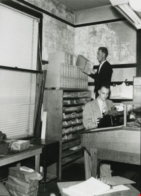
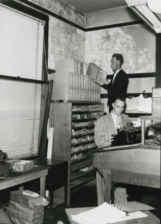
Building fatigue
https://search.heritageburnaby.ca/link/archivedescription36566
- Repository
- City of Burnaby Archives
- Date
- 1952
- Collection/Fonds
- Burnaby Historical Society fonds
- Description Level
- Item
- Physical Description
- 1 photograph : b&w ; 17.5 x 12.5 cm print
- Scope and Content
- Photograph of "BUILDING FATIGUE" inside the second Burnaby Municipal Hall.
- Repository
- City of Burnaby Archives
- Date
- 1952
- Collection/Fonds
- Burnaby Historical Society fonds
- Subseries
- Archie Miller subseries
- Physical Description
- 1 photograph : b&w ; 17.5 x 12.5 cm print
- Description Level
- Item
- Record No.
- 296-009
- Access Restriction
- No restrictions
- Reproduction Restriction
- Reproduce for fair dealing purposes only
- Accession Number
- BHS1992-36
- Scope and Content
- Photograph of "BUILDING FATIGUE" inside the second Burnaby Municipal Hall.
- Names
- Burnaby City Hall
- Media Type
- Photograph
- Photographer
- Dibble, Bob
- Notes
- Title taken from caption given to photograph in original pamphlet
- Photographs copies of originals used in "UNITE BURNABY" pamphlet which asked citizens to "VOTE YES" to the construction of a new Municipal Hall in Burnaby
- Geographic Access
- Kingsway
- Street Address
- 7282 Kingsway
- Historic Neighbourhood
- Edmonds (Historic Neighbourhood)
- Planning Study Area
- Stride Avenue Area
Images
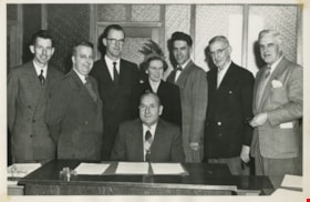
Burnaby Council
https://search.heritageburnaby.ca/link/archivedescription55647
- Repository
- City of Burnaby Archives
- Date
- 1954
- Collection/Fonds
- Charles MacSorley fonds
- Description Level
- Item
- Physical Description
- 1 photograph : b&w ; 17 x 25.5 cm
- Scope and Content
- Photograph of the eight members of Burnaby's 1954 Municipal Council. From left to right they are; Fred Philps, Wesley Morrison, Arnold Hean, Reeve Charles MacSorley (seated), Patricia Wilks, Sam Hughes, William Philps, and Gerald Charlton. This photograph was likely taken in Burnaby Municipal Hall.
- Repository
- City of Burnaby Archives
- Date
- 1954
- Collection/Fonds
- Charles MacSorley fonds
- Physical Description
- 1 photograph : b&w ; 17 x 25.5 cm
- Description Level
- Item
- Record No.
- 486-041
- Access Restriction
- No restrictions
- Reproduction Restriction
- Reproduce for fair dealing purposes only
- Accession Number
- 2005-14
- Scope and Content
- Photograph of the eight members of Burnaby's 1954 Municipal Council. From left to right they are; Fred Philps, Wesley Morrison, Arnold Hean, Reeve Charles MacSorley (seated), Patricia Wilks, Sam Hughes, William Philps, and Gerald Charlton. This photograph was likely taken in Burnaby Municipal Hall.
- Names
- Philps, Fred
- Philps, William P.
- Morrison, Wesley
- Hean, Arnold F.C.
- MacSorley, Charles W.
- Wilks, Patricia
- Hughes, Samuel E.
- Charlton, Gerald
- Media Type
- Photograph
- Photographer
- Davis, W.T.
- Notes
- Title based on contents of photograph
- Photographer's stamp on verso
- Note on verso identifies the people in the photograph
- Note on verso reads: "1954"
- Geographic Access
- Kingsway
- Street Address
- 7282 Kingsway
- Historic Neighbourhood
- Edmonds (Historic Neighbourhood)
- Planning Study Area
- Stride Avenue Area
Images

![Burnaby Girl Guides, [1914]-1969, predominant ca. 1920 (date of original), copied 2016 thumbnail](/media/hpo/_Data/_BVM_Images/2015/2015_0035_0164_folded.jpg?width=280)
Burnaby Girl Guides
https://search.heritageburnaby.ca/link/museumdescription4592
- Repository
- Burnaby Village Museum
- Date
- [1914]-1969, predominant ca. 1920 (date of original), copied 2016
- Collection/Fonds
- Burnaby Girl Guides fonds
- Description Level
- File
- Physical Description
- 1 scrapbook (textual records + 2 digital files : (pdfs) + 102 photographs : (tiffs))
- Scope and Content
- File consists of images and selected contents from a scrapbook with 38 double sided pages containing mostly photographs with some newspaper clippings, written material and emphemera including a page of badges and ribbons which reads "Enrolment & Membership Card of / Joan Bailey 1926 / 1st Burnaby" …
- Repository
- Burnaby Village Museum
- Collection/Fonds
- Burnaby Girl Guides fonds
- Description Level
- File
- Physical Description
- 1 scrapbook (textual records + 2 digital files : (pdfs) + 102 photographs : (tiffs))
- Scope and Content
- File consists of images and selected contents from a scrapbook with 38 double sided pages containing mostly photographs with some newspaper clippings, written material and emphemera including a page of badges and ribbons which reads "Enrolment & Membership Card of / Joan Bailey 1926 / 1st Burnaby" and an embroidered alphabet of the Morse Code. The third page of the scrapbook includes a four page chronology titled "History of Guiding - Burnaby / 1913 - 1960" compiled by Mrs. Dolly Weber, Mrs. J. Heaps, Miss Eileen Periton, Mrs. J. Albertson and D. Fowler. The scrapbook also includes an original letter and post-script from Lady Olave Baden-Powell to Mrs. Fowler dated November 5, 1961; a typewritten copy of: "TSOONA" / PROVINCIAL GUIDE CAMPSITE - ROSEDALE B.C." and a three page typewritten copy of "THE CAMPFIRE / Volume 1, No. 4 _ November 1935 _ Vancouver, B.C.". Many of the events documented in photographs [between 1914 and 1969] are identified on each page and read as the following: "Burnaby Brownies - Guides & Rangers" / "Early 1920" (1 photograph); "Ambulance / Display / 1st. Co."; "Girl Guide Rally - New Westminster and / Burnaby - June 16, 1923" (5 photographs); "Girl Guide Rally - New Westminster and / Burnaby - June 16, 1923" (5 photographs); "Burnaby Guides and / Brownies / June 17, 1923" (5 photographs); "April 1923" (1 photograph); "June 1923 / 2nd Burnaby Company" (1 photograph); "Burnaby May Day / 26.5.28"(2 photographs); "Sechelt 1929_ 2nd "B" Company" (2 photographs); "Leaders and Seconds / 2nd Burnaby / Grouse Mountain" (1 photograph); "Sechelt 1929 / Commandant Mrs. Peal" (1 photograph); "2nd Company / June 1930" (1 photograph); "1932 / 2nd Company at Rally / Municipal Hall Grounds" (1 photograph) ; "First Burnaby Folk Dancing team / Winners of the E.F.D. cup 1940--41-42" (1 photograph); "1st Burnaby Company / winners of Bessborough Shield / 1942 / Captain L. Crane" (1 photograph); "May 6th 1935 / Dedication of flag at Central Park" (1 photograph); "May Day Celebration / Burnaby B.C. May 6th 1935 / Stride Studios Photos" (1 photograph); "Mrs. Don Wilks / Mrs. Georgie / Runcie / Publicity Photo re- / Brownie / Training / 1958-60" (1 photograph); "Kathleen Anderson / about 1958-60?" (1 photograph); "1957 / Burnaby Camp Site / at / Wilson Creek" (1 photograph); "Work Party (1958)" (1 photograph); "Burnaby Camp Site / Spring 1958 / Cabins & Staff Houses / Dining Shelter / Cabins" (3 photographs); "Can. Girl Guide Assoc. - Provincial Leaders Conference / April 14-15/61 Civic Centre, Prince George, BC" (1 photograph) ; "June 8th, 1958 / Opening / Ceremonies / Burnaby Site / Wilson Creek / Camp Site" (4 photographs); 2 unidentified photographs [ca.1915] of a large group of Girl Guides gathered on the Pacific National Exhibition grounds (photo credit- Leonard Frank); 1 unidentified photograph of a group of Girl Guides gathered for a group portrait [ca.1914]; "Girl Guide Camp / Granthams / Landing / July 1923" (4 photographs); 4 unidentified photographs of girl guides gathered on the ship "Lady Evelyn" [ca. 1920]; "Burnaby Girl Guides" 1918; "First Burnaby Girl Guides 1920" (2 photographs on page); "2nd Co. 1923" (1 photograph) "1st Burnaby Co." [1923] (1 photograph); "Gypsy Scene - Concert / Mar 17, 1923 / Unveiling / War / Memorial / Edmonds / 1923" (3 photographs on page); "Faith Jacobson / 1961" (2 photographs); "Eve MacLean / 1961" (1 photograph); "Beverley Simkin of Montreal and Judy Robins / of the S.R.S. Royal Oak taken on the day they / sailed from Montreal for the Ranger Camp at / "Our Chalet" in Adelboden, Switzerland, May 1962" (1 photograph) and "Religion & Life Emblem / Diane Peters 11th Bby. Co. / Rev. G.W. Luetkehodeter / 1961" (2 photographs on one page).
- Names
- Girl Guides of Canada
- Accession Code
- BV015.35.164
- Access Restriction
- No restrictions
- Reproduction Restriction
- May be restricted by third party rights
- Date
- [1914]-1969, predominant ca. 1920 (date of original), copied 2016
- Media Type
- Photograph
- Textual Record
- Historic Neighbourhood
- Edmonds (Historic Neighbourhood)
- Central Park (Historic Neighbourhood)
- Planning Study Area
- Edmonds Area
- Maywood Area
- Notes
- Transcribed title
- Digital images were created of the scrapbook prior to selective retention of original records that were removed for conservation purposes
- Some textual records that were selected for retention have been described at file level under BV015.35.164: "Tsoona" Provincial Guide Campsite - Rosedale B.C." and Burnaby Girl Guides newsletter, "The Campfire" (November 1935)
- Photographs that were retained from scrapbook have been described at item level (BV015.35.221 to BV015.35.284)
- Some textual records and ephemera that were selected for retention have been described at item level (BV015.35.320, BV015.35.321, and BV015.35.334 to BV015.35.348).
Images
![Burnaby Girl Guides, [1914]-1969, predominant ca. 1920 (date of original), copied 2016 thumbnail](/media/hpo/_Data/_BVM_Images/2015/2015_0035_0164_folded.jpg)
Documents
![Burnaby South High School, [1956] thumbnail](/media/Hpo/_Data/_BVM_Images/2016/2016_0046_0117_001.jpg?width=280)
Burnaby South High School
https://search.heritageburnaby.ca/link/museumdescription5162
- Repository
- Burnaby Village Museum
- Date
- [1956]
- Collection/Fonds
- Waplington family fonds
- Description Level
- Item
- Physical Description
- 1 photograph : b&w ; 12.7 x 18 cm
- Scope and Content
- Photograph a group of unidentifed students from Burnaby South High School. Photograph is taken at the front entrance of the school with the sign "Burnaby.South / High School" on the wall above the entrance way. Edith Louise Fleming graduated from Burnaby South High School in June 1956.
- Repository
- Burnaby Village Museum
- Collection/Fonds
- Waplington family fonds
- Description Level
- Item
- Physical Description
- 1 photograph : b&w ; 12.7 x 18 cm
- Scope and Content
- Photograph a group of unidentifed students from Burnaby South High School. Photograph is taken at the front entrance of the school with the sign "Burnaby.South / High School" on the wall above the entrance way. Edith Louise Fleming graduated from Burnaby South High School in June 1956.
- Geographic Access
- Southoaks Crescent
- Street Address
- 6650 Southoaks Crescent
- Accession Code
- BV016.46.117
- Access Restriction
- No restrictions
- Reproduction Restriction
- No known restrictions
- Date
- [1956]
- Media Type
- Photograph
- Historic Neighbourhood
- Edmonds (Historic Neighbourhood)
- Planning Study Area
- Kingsway-Beresford Area
- Scan Resolution
- 600
- Scan Date
- 13-Aug-2018
- Notes
- Title based on contents of photograph
- Note in blue ink on verso of photograph reads: "A "fun" photo - BBY SOUTH"
- Stamp on verso reads: "E.M. ALLEN LTD. / 2870 West Broadway / Vancouver 8, B.C."
- Photograph is part of Photograph album BV016.46.52
Images
![Burnaby South High School, [1956] thumbnail](/media/Hpo/_Data/_BVM_Images/2016/2016_0046_0117_001.jpg)
![Burnaby South High School class, [1952] (date of original), digitally copied 2012 thumbnail](/media/hpo/_Data/_Archives_Images/_Unrestricted/540/549-038.jpg?width=280)
Burnaby South High School class
https://search.heritageburnaby.ca/link/archivedescription75095
- Repository
- City of Burnaby Archives
- Date
- [1952] (date of original), digitally copied 2012
- Collection/Fonds
- Community Heritage Commission Special Projects fonds
- Description Level
- Item
- Physical Description
- 1 photograph (jpeg) : col. ; 300ppi
- Scope and Content
- Photograph of a Burnaby South High School class. Kay O'Cook (later Jackson) is in the middle row, third from the right.
- Repository
- City of Burnaby Archives
- Date
- [1952] (date of original), digitally copied 2012
- Collection/Fonds
- Community Heritage Commission Special Projects fonds
- Physical Description
- 1 photograph (jpeg) : col. ; 300ppi
- Description Level
- Item
- Record No.
- 549-038
- Access Restriction
- No restrictions
- Reproduction Restriction
- Reproduce for fair dealing purposes only
- Accession Number
- 2012-30
- Scope and Content
- Photograph of a Burnaby South High School class. Kay O'Cook (later Jackson) is in the middle row, third from the right.
- Media Type
- Photograph
- Notes
- Title based on contents of photograph
- Geographic Access
- Southoaks Crescent
- Street Address
- 6650 Southoaks Crescent
- Historic Neighbourhood
- Edmonds (Historic Neighbourhood)
- Planning Study Area
- Kingsway-Beresford Area
Images
![Burnaby South High School class, [1952] (date of original), digitally copied 2012 thumbnail](/media/hpo/_Data/_Archives_Images/_Unrestricted/540/549-038.jpg)