Narrow Results By
Subject
- Building Components 1
- Buildings - Commercial 1
- Buildings - Commercial - General Stores 1
- Buildings - Commercial - Grocery Stores 1
- Buildings - Industrial - Factories 1
- Buildings - Recreational - Community Halls 1
- Buildings - Religious - Churches 1
- Buildings - Residential - Houses 1
- Buildings - Schools 6
- Ceremonies - Weddings 1
- Documentary Artifacts - Programs 1
- Events - May Day 1
Creator
- Barrowclough, George Alfred 1
- Bridgman's Studio Limited 1
- British Columbia Underwriters' Association 2
- Burnett and McGugan B.C. Land Surveyors, New Westminster 2
- Dalton & Eveleigh 1
- Edmonds Junior Secondary School 2
- Friends of Interurban 1223 1
- Garden, Hermon and Burwell 1
- Hadwin, Juanita 7
- King Studio Photographers 1
- McGeachie, Pixie, 1921- 2
- McGugan, Donald Johnston 1
![Middlegate Shopping Centre property, [between 2003 and 2004] thumbnail](/media/hpo/_Data/_BVM_Images/2022/2022_0012_0001_001.jpg?width=280)
Middlegate Shopping Centre property
https://search.heritageburnaby.ca/link/museumdescription18738
- Repository
- Burnaby Village Museum
- Date
- [between 2003 and 2004]
- Collection/Fonds
- Burnaby Village Museum Photograph collection
- Description Level
- Item
- Physical Description
- 1 photograph : col. print ; 10 x 25.5 cm
- Scope and Content
- Photograph looking south down Hall Avenue between Collier Street and Kingsway. The Middlegate Shopping Centre property and future site of the Highgate Village development is visible to the right. The Arcadia condominium presentation centre is visible on the on the lot near Kingsway and highrise apa…
- Repository
- Burnaby Village Museum
- Collection/Fonds
- Burnaby Village Museum Photograph collection
- Description Level
- Item
- Physical Description
- 1 photograph : col. print ; 10 x 25.5 cm
- Scope and Content
- Photograph looking south down Hall Avenue between Collier Street and Kingsway. The Middlegate Shopping Centre property and future site of the Highgate Village development is visible to the right. The Arcadia condominium presentation centre is visible on the on the lot near Kingsway and highrise apartment buildings in the distance.
- Geographic Access
- Hall Avenue
- Accession Code
- BV022.12.1
- Access Restriction
- No restrictions
- Reproduction Restriction
- No known restrictions
- Date
- [between 2003 and 2004]
- Media Type
- Photograph
- Historic Neighbourhood
- Edmonds (Historic Neighbourhood)
- Planning Study Area
- Edmonds Area
- Scan Resolution
- 600
- Scan Date
- 2022-05-17
- Photographer
- Hadwin, Juanita
- Notes
- Title based on contents of photograph
Images
![Middlegate Shopping Centre property, [between 2003 and 2004] thumbnail](/media/hpo/_Data/_BVM_Images/2022/2022_0012_0001_001.jpg)
![Northwest corner of Middlegate Shopping Centre property, [between 2003 and 2004] thumbnail](/media/hpo/_Data/_BVM_Images/2022/2022_0012_0002_001.jpg?width=280)
Northwest corner of Middlegate Shopping Centre property
https://search.heritageburnaby.ca/link/museumdescription18739
- Repository
- Burnaby Village Museum
- Date
- [between 2003 and 2004]
- Collection/Fonds
- Burnaby Village Museum Photograph collection
- Description Level
- Item
- Physical Description
- 1 photograph : col. print ; 10 x 25.5 cm
- Scope and Content
- Photograph of the northwest corner of the Middlegate Shopping Centre property looking southeast from Collier Street towards Hall Avenue and Kingsway. White building was a liquor store. Future site of Highgate Village development.
- Repository
- Burnaby Village Museum
- Collection/Fonds
- Burnaby Village Museum Photograph collection
- Description Level
- Item
- Physical Description
- 1 photograph : col. print ; 10 x 25.5 cm
- Scope and Content
- Photograph of the northwest corner of the Middlegate Shopping Centre property looking southeast from Collier Street towards Hall Avenue and Kingsway. White building was a liquor store. Future site of Highgate Village development.
- Geographic Access
- Collier Street
- Accession Code
- BV022.12.2
- Access Restriction
- No restrictions
- Reproduction Restriction
- No known restrictions
- Date
- [between 2003 and 2004]
- Media Type
- Photograph
- Historic Neighbourhood
- Edmonds (Historic Neighbourhood)
- Planning Study Area
- Edmonds Area
- Scan Resolution
- 600
- Scan Date
- 2022-05-17
- Photographer
- Hadwin, Juanita
- Notes
- Title based on contents of photograph
Images
![Northwest corner of Middlegate Shopping Centre property, [between 2003 and 2004] thumbnail](/media/hpo/_Data/_BVM_Images/2022/2022_0012_0002_001.jpg)
![Northwest corner of Middlegate Shopping Centre property, [between 2003 and 2004] thumbnail](/media/hpo/_Data/_BVM_Images/2022/2022_0012_0003_001.jpg?width=280)
Northwest corner of Middlegate Shopping Centre property
https://search.heritageburnaby.ca/link/museumdescription18740
- Repository
- Burnaby Village Museum
- Date
- [between 2003 and 2004]
- Collection/Fonds
- Burnaby Village Museum Photograph collection
- Description Level
- Item
- Physical Description
- 1 photograph : col. print ; 10 x 25.5 cm
- Scope and Content
- Photograph of the northwest corner of the Middlegate Shopping Centre property looking southeast from Collier Street towards Hall Avenue and Kingsway. White building was a liquor store. Future site of Highgate Village development.
- Repository
- Burnaby Village Museum
- Collection/Fonds
- Burnaby Village Museum Photograph collection
- Description Level
- Item
- Physical Description
- 1 photograph : col. print ; 10 x 25.5 cm
- Scope and Content
- Photograph of the northwest corner of the Middlegate Shopping Centre property looking southeast from Collier Street towards Hall Avenue and Kingsway. White building was a liquor store. Future site of Highgate Village development.
- Geographic Access
- Collier Street
- Accession Code
- BV022.12.3
- Access Restriction
- No restrictions
- Reproduction Restriction
- No known restrictions
- Date
- [between 2003 and 2004]
- Media Type
- Photograph
- Historic Neighbourhood
- Edmonds (Historic Neighbourhood)
- Planning Study Area
- Edmonds Area
- Scan Resolution
- 600
- Scan Date
- 2022-05-17
- Photographer
- Hadwin, Juanita
- Notes
- Title based on contents of photograph
Images
![Northwest corner of Middlegate Shopping Centre property, [between 2003 and 2004] thumbnail](/media/hpo/_Data/_BVM_Images/2022/2022_0012_0003_001.jpg)
![Excavator at north end of Middlegate Shopping Centre property, [between 2003 and 2004] thumbnail](/media/hpo/_Data/_BVM_Images/2022/2022_0012_0004_001.jpg?width=280)
Excavator at north end of Middlegate Shopping Centre property
https://search.heritageburnaby.ca/link/museumdescription18741
- Repository
- Burnaby Village Museum
- Date
- [between 2003 and 2004]
- Collection/Fonds
- Burnaby Village Museum Photograph collection
- Description Level
- Item
- Physical Description
- 1 photograph : col. print ; 10 x 25.5 cm
- Scope and Content
- Photograph of an excavator at the north end of the Middlegate Shopping Centre property, future site of the Highgate Village development. Looking south from Hall Avenue near Balmoral Street. Three storey apartment building is located at 7030 Hall Avenue.
- Repository
- Burnaby Village Museum
- Collection/Fonds
- Burnaby Village Museum Photograph collection
- Description Level
- Item
- Physical Description
- 1 photograph : col. print ; 10 x 25.5 cm
- Scope and Content
- Photograph of an excavator at the north end of the Middlegate Shopping Centre property, future site of the Highgate Village development. Looking south from Hall Avenue near Balmoral Street. Three storey apartment building is located at 7030 Hall Avenue.
- Geographic Access
- Hall Avenue
- Accession Code
- BV022.12.4
- Access Restriction
- No restrictions
- Reproduction Restriction
- No known restrictions
- Date
- [between 2003 and 2004]
- Media Type
- Photograph
- Historic Neighbourhood
- Edmonds (Historic Neighbourhood)
- Planning Study Area
- Edmonds Area
- Scan Resolution
- 600
- Scan Date
- 2022-05-17
- Photographer
- Hadwin, Juanita
- Notes
- Title based on contents of photograph
Images
![Excavator at north end of Middlegate Shopping Centre property, [between 2003 and 2004] thumbnail](/media/hpo/_Data/_BVM_Images/2022/2022_0012_0004_001.jpg)
![Excavator on northeast corner of Middlegate Shopping Centre property, [between 2003 and 2004] thumbnail](/media/hpo/_Data/_BVM_Images/2022/2022_0012_0005_001.jpg?width=280)
Excavator on northeast corner of Middlegate Shopping Centre property
https://search.heritageburnaby.ca/link/museumdescription18742
- Repository
- Burnaby Village Museum
- Date
- [between 2003 and 2004]
- Collection/Fonds
- Burnaby Village Museum Photograph collection
- Description Level
- Item
- Physical Description
- 1 photograph : col. print ; 10 x 25.5 cm
- Scope and Content
- Photograph of excavator on the site of the Middlegate Shopping Centre property, future site of the Highgate Village development. Northeast corner of Collier Street and Hall Avenue looking south west across site towards Kingsway with highrises in the distance.
- Repository
- Burnaby Village Museum
- Collection/Fonds
- Burnaby Village Museum Photograph collection
- Description Level
- Item
- Physical Description
- 1 photograph : col. print ; 10 x 25.5 cm
- Scope and Content
- Photograph of excavator on the site of the Middlegate Shopping Centre property, future site of the Highgate Village development. Northeast corner of Collier Street and Hall Avenue looking south west across site towards Kingsway with highrises in the distance.
- Geographic Access
- Collier Street
- Accession Code
- BV022.12.5
- Access Restriction
- No restrictions
- Reproduction Restriction
- No known restrictions
- Date
- [between 2003 and 2004]
- Media Type
- Photograph
- Historic Neighbourhood
- Edmonds (Historic Neighbourhood)
- Planning Study Area
- Edmonds Area
- Scan Resolution
- 600
- Scan Date
- 2022-05-17
- Photographer
- Hadwin, Juanita
- Notes
- Title based on contents of photograph
Images
![Excavator on northeast corner of Middlegate Shopping Centre property, [between 2003 and 2004] thumbnail](/media/hpo/_Data/_BVM_Images/2022/2022_0012_0005_001.jpg)
![Excavator on northeast corner of Middlegate Shopping Centre property, [between 2003 and 2004] thumbnail](/media/hpo/_Data/_BVM_Images/2022/2022_0012_0006_001.jpg?width=280)
Excavator on northeast corner of Middlegate Shopping Centre property
https://search.heritageburnaby.ca/link/museumdescription18743
- Repository
- Burnaby Village Museum
- Date
- [between 2003 and 2004]
- Collection/Fonds
- Burnaby Village Museum Photograph collection
- Description Level
- Item
- Physical Description
- 1 photograph : col. print ; 10 x 25.5 cm
- Scope and Content
- Photograph of excavator on the site of the Middlegate Shopping Centre property, future site of the Highgate Village development. Northeast corner of Collier Street and Hall Avenue looking south west across site towards Kingsway with highrises in the distance.
- Repository
- Burnaby Village Museum
- Collection/Fonds
- Burnaby Village Museum Photograph collection
- Description Level
- Item
- Physical Description
- 1 photograph : col. print ; 10 x 25.5 cm
- Scope and Content
- Photograph of excavator on the site of the Middlegate Shopping Centre property, future site of the Highgate Village development. Northeast corner of Collier Street and Hall Avenue looking south west across site towards Kingsway with highrises in the distance.
- Geographic Access
- Collier Street
- Accession Code
- BV022.12.6
- Access Restriction
- No restrictions
- Reproduction Restriction
- No known restrictions
- Date
- [between 2003 and 2004]
- Media Type
- Photograph
- Historic Neighbourhood
- Edmonds (Historic Neighbourhood)
- Planning Study Area
- Edmonds Area
- Scan Resolution
- 600
- Scan Date
- 2022-05-17
- Photographer
- Hadwin, Juanita
- Notes
- Title based on contents of photograph
Images
![Excavator on northeast corner of Middlegate Shopping Centre property, [between 2003 and 2004] thumbnail](/media/hpo/_Data/_BVM_Images/2022/2022_0012_0006_001.jpg)
![Middlegate Shopping Centre property, [between 2003 and 2004] thumbnail](/media/hpo/_Data/_BVM_Images/2022/2022_0012_0007_001.jpg?width=280)
Middlegate Shopping Centre property
https://search.heritageburnaby.ca/link/museumdescription18744
- Repository
- Burnaby Village Museum
- Date
- [between 2003 and 2004]
- Collection/Fonds
- Burnaby Village Museum Photograph collection
- Description Level
- Item
- Physical Description
- 1 photograph : col. print ; 10 x 25.5 cm
- Scope and Content
- Photograph looking south down Hall Avenue between Collier Street and Kingsway. The Middlegate Shopping Centre property and future site of the Highgate Village development is visible to the right. The Arcadia condominium presentation centre is visible on the on the lot near Kingsway and highrise apa…
- Repository
- Burnaby Village Museum
- Collection/Fonds
- Burnaby Village Museum Photograph collection
- Description Level
- Item
- Physical Description
- 1 photograph : col. print ; 10 x 25.5 cm
- Scope and Content
- Photograph looking south down Hall Avenue between Collier Street and Kingsway. The Middlegate Shopping Centre property and future site of the Highgate Village development is visible to the right. The Arcadia condominium presentation centre is visible on the on the lot near Kingsway and highrise apartment buildings in the distance.
- Geographic Access
- Hall Avenue
- Accession Code
- BV022.12.7
- Access Restriction
- No restrictions
- Reproduction Restriction
- No known restrictions
- Date
- [between 2003 and 2004]
- Media Type
- Photograph
- Historic Neighbourhood
- Edmonds (Historic Neighbourhood)
- Planning Study Area
- Edmonds Area
- Scan Resolution
- 600
- Scan Date
- 2022-05-17
- Photographer
- Hadwin, Juanita
- Notes
- Title based on contents of photograph
Images
![Middlegate Shopping Centre property, [between 2003 and 2004] thumbnail](/media/hpo/_Data/_BVM_Images/2022/2022_0012_0007_001.jpg)
Follow that fire : the history of the Burnaby Fire Department
https://search.heritageburnaby.ca/link/museumlibrary5194
- Repository
- Burnaby Village Museum
- Publication Date
- 1997
- Call Number
- 363.378 PEN COPY 3
hose for 25 cents a foot on August 12, 1912, to protect the police
horse stables. When the police received a fire call, Burnaby relied on other munici-
palities for aid. The New Westminster Fire Department responded to the Edmonds
area, the South Vancouver Fire Department responded to the Central Park
- Repository
- Burnaby Village Museum
- Collection
- Digital Reference Collection
- Material Type
- Book
- ISBN
- 0969282826
- Call Number
- 363.378 PEN COPY 3
- Place of Publication
- [Burnaby, B.C.]
- Publisher
- City of Burnaby
- Publication Date
- 1997
- Physical Description
- 160 p. : ill. (some col.), 2 maps, ports. (some col.) ; 29 cm.
- Library Subject (LOC)
- Fire departments
- Fire fighters
- Name Access
- Burnaby Fire Department
- Notes
- Maps on lining papers.
- 3 copies held: copy 3.
Digital Books
Burnaby centennial anthology : stories of early Burnaby
https://search.heritageburnaby.ca/link/museumlibrary5472
- Repository
- Burnaby Village Museum
- Edition
- Rev. ed.
- Publication Date
- 1994
- Call Number
- 971.133 BUR COPY 3
- Repository
- Burnaby Village Museum
- Collection
- Digital Reference Collection
- Material Type
- Book
- ISBN
- 0969282826
- Call Number
- 971.133 BUR COPY 3
- Edition
- Rev. ed.
- Place of Publication
- Burnaby, B.C.
- Publisher
- City of Burnaby
- Publication Date
- 1994
- Physical Description
- 531 p. : ill. ; 28 cm.
- Library Subject (LOC)
- Burnaby (B.C.)--History
- Burnaby (B.C.)
- Biography
- Notes
- Includes index.
- 3 copies held: copy 3.
Digital Books

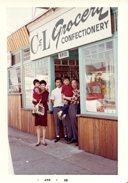
Members of Lee family in front of C&L Grocery Confectionery
https://search.heritageburnaby.ca/link/museumdescription16719
- Repository
- Burnaby Village Museum
- Date
- April 1968
- Collection/Fonds
- Quon Lip Lee fonds
- Description Level
- Item
- Physical Description
- 1 photograph (tiff)
- Scope and Content
- Photograph of Quon Lip Lee (right) and his eldest son, Gary Lee (centre) standing together with his niece and her children in front of the Lee family corner store, C&L Grocery & Confectionery. The store is located at 6912 Kingsway (corner of Kingsway and Griffiths) and was owned by Quon Lip Lee.
- Repository
- Burnaby Village Museum
- Collection/Fonds
- Quon Lip Lee fonds
- Description Level
- Item
- Physical Description
- 1 photograph (tiff)
- Scope and Content
- Photograph of Quon Lip Lee (right) and his eldest son, Gary Lee (centre) standing together with his niece and her children in front of the Lee family corner store, C&L Grocery & Confectionery. The store is located at 6912 Kingsway (corner of Kingsway and Griffiths) and was owned by Quon Lip Lee.
- Geographic Access
- Kingsway
- Street Address
- 6912 Kingsway
- Accession Code
- BV021.18.3
- Access Restriction
- No restrictions
- Reproduction Restriction
- May be restricted by third party rights
- Date
- April 1968
- Media Type
- Photograph
- Historic Neighbourhood
- Edmonds (Historic Neighbourhood)
- Planning Study Area
- Edmonds Area
- Scan Resolution
- 600
- Scan Date
- April 8, 2021
- Scale
- 100
- Notes
- Title based on contents of photograph
- Date stamp on bottom recto of photograph reads: "APR_68"
Images
Edmonds Niner 1958-1959
https://search.heritageburnaby.ca/link/museumlibrary7505
- Repository
- Burnaby Village Museum
- Collection
- Special Collection
- Material Type
- Book
- Accession Code
- BV020.15.1
- Call Number
- 373.71 EDM 1959
- Contributor
- Edmonds Junior Secondary School
- Place of Publication
- Burnaby
- Publisher
- Edmonds Junior Secondary School
- Publication Date
- 1959
- Physical Description
- ill : 28 cm
- Library Subject (LOC)
- Schools--British Columbia--Burnaby
- School yearbooks
- Historic Neighbourhood
- Edmonds (Historic Neighbourhood)
- Planning Study Area
- Edmonds Area
- Names
- Edmonds Community School
- Notes
- Yearbook for Grade 9 students.

Twelfth Avenue Elementary School
https://search.heritageburnaby.ca/link/landmark848
- Repository
- Burnaby Heritage Planning
- Geographic Access
- 12th Avenue
- Associated Dates
- 1958
- Heritage Value
- Twelfth Avenue School was one of two schools built to relieve the overcrowding at Edmonds School resulting from the housing boom in Burnaby during the 1950s - Lakeview was the other. Built in 1958, the building was added to in 1962, 1964, 1967, 1969 and 1974.
- Historic Neighbourhood
- Edmonds (Historic Neighbourhood)
- Planning Study Area
- Edmonds Area
- Street Address
- 7622 12th Avenue
- Street View URL
- Google Maps Street View
Images

Edmonds Niner 1858-1958
https://search.heritageburnaby.ca/link/museumlibrary7504
- Repository
- Burnaby Village Museum
- Collection
- Special Collection
- Material Type
- Book
- Accession Code
- BV020.15.2
- Call Number
- 373.71 EDM 1959
- Contributor
- Edmonds Junior Secondary School
- Place of Publication
- Burnaby
- Publisher
- Edmonds Junior Secondary
- Publication Date
- 1958
- Physical Description
- ill : 28 cm.
- Library Subject (LOC)
- Schools--British Columbia--Burnaby
- School yearbooks
- Historic Neighbourhood
- Edmonds (Historic Neighbourhood)
- Planning Study Area
- Edmonds Area
- Names
- Edmonds Community School
- Notes
- Special yearbook for Grade 9 students. This issue in 1958 was also commemorating 100 years of the school.
![Girl Guide open house at St. Alban's, [1948] thumbnail](/media/hpo/_Data/_BVM_Images/2015/2015_0035_0204_001.jpg?width=280)
Girl Guide open house at St. Alban's
https://search.heritageburnaby.ca/link/museumdescription4853
- Repository
- Burnaby Village Museum
- Date
- [1948]
- Collection/Fonds
- Burnaby Girl Guides fonds
- Description Level
- Item
- Physical Description
- 1 photograph : b&w : 7 x 11.5 cm
- Scope and Content
- Photograph of three Girl Guides from the Second Burnaby Girl Guide company. The girls are in uniform and one is holding a union jack flag on a pole. They are standing outside St. Alban's Anglican church hall where the company held an open house. Special guests were Miss E. Periton, District Commiss…
- Repository
- Burnaby Village Museum
- Collection/Fonds
- Burnaby Girl Guides fonds
- Description Level
- Item
- Physical Description
- 1 photograph : b&w : 7 x 11.5 cm
- Scope and Content
- Photograph of three Girl Guides from the Second Burnaby Girl Guide company. The girls are in uniform and one is holding a union jack flag on a pole. They are standing outside St. Alban's Anglican church hall where the company held an open house. Special guests were Miss E. Periton, District Commissioner; Miss F. McGeachie District Captain and Rev. N.J. Thompson. Representatives of the Second Burnaby Scout troop and the First Burnaby Brownie Pack were present. Patrol Leader, Seconds, stripes, lanyards and service stars were awarded. Shield for the neatest guide was presented to Norma McDonald.
- Geographic Access
- 19th Avenue
- Street Address
- 7717 19th Avenue
- Accession Code
- BV015.35.204
- Access Restriction
- No restrictions
- Reproduction Restriction
- No known restrictions
- Date
- [1948]
- Media Type
- Photograph
- Historic Neighbourhood
- Edmonds (Historic Neighbourhood)
- Planning Study Area
- Edmonds Area
- Scan Resolution
- 600
- Scan Date
- 06/11/2018
- Notes
- Title based on contents of photograph
- Photograph is a part of original scrapbook "Girl Guiding. -- 1939-1951" (page 11/18) Item BV015.35.160
Images
![Girl Guide open house at St. Alban's, [1948] thumbnail](/media/hpo/_Data/_BVM_Images/2015/2015_0035_0204_001.jpg)
Folk dancing team
https://search.heritageburnaby.ca/link/museumdescription4861
- Repository
- Burnaby Village Museum
- Date
- 1936
- Collection/Fonds
- Burnaby Girl Guides fonds
- Description Level
- Item
- Physical Description
- 1 photograph : sepia ; 6.2 x 8.5 cm
- Scope and Content
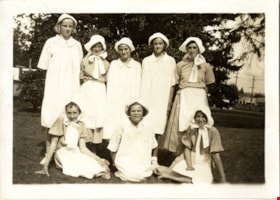
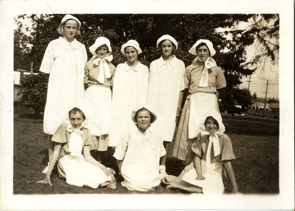
- Photograph of the 1st Burnaby Girl Guide company folk dancing team at a garden party at the Municipal Hall at Edmonds in 1936. The guides are dressed in white bonnets and dresses and are identified in the top row L to R: Phyllis Lockhart, Margaret Wilson, Marion Bellinger, Betty Martin and Peggy U…
- Repository
- Burnaby Village Museum
- Collection/Fonds
- Burnaby Girl Guides fonds
- Description Level
- Item
- Physical Description
- 1 photograph : sepia ; 6.2 x 8.5 cm
- Scope and Content
- Photograph of the 1st Burnaby Girl Guide company folk dancing team at a garden party at the Municipal Hall at Edmonds in 1936. The guides are dressed in white bonnets and dresses and are identified in the top row L to R: Phyllis Lockhart, Margaret Wilson, Marion Bellinger, Betty Martin and Peggy Urquhart and bottom row L to R : Joan Warburton, Kay Lambert and Joan Mortimer.
- Names
- Lockhart, Phyllis
- Wilson, Margaret
- Bellinger, Marion
- Martin, Betty
- Urquhart, Peggy
- Blair, Betty Warburton Atkinson
- Lambert, Kay
- Mortimer, Joan
- Girl Guides of Canada
- Accession Code
- BV015.35.219
- Access Restriction
- No restrictions
- Reproduction Restriction
- No known restrictions
- Date
- 1936
- Media Type
- Photograph
- Historic Neighbourhood
- Edmonds (Historic Neighbourhood)
- Planning Study Area
- Edmonds Area
- Scan Resolution
- 600
- Scan Date
- February 2, 2021
- Scale
- 100
- Notes
- Transcribed title
- Photograph is part of scrapbook BV015.35.162
Images
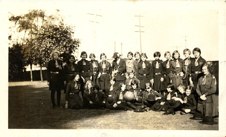
Second Burnaby Girl Guide Company at rally
https://search.heritageburnaby.ca/link/museumdescription4889
- Repository
- Burnaby Village Museum
- Date
- Jun 20, 1932
- Collection/Fonds
- Burnaby Girl Guides fonds
- Description Level
- Item
- Physical Description
- 1 photograph : sepia ; 7 x 11.5 cm
- Scope and Content
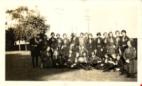
- Photograph of the Second (2nd) Burnaby Girl Guide Company and leaders at a Burnaby Division rally on the grounds of the Burnaby Municipal Hall on Saturday June 20, 1932. The rally took place in the presence of the deputy provincial commissioner, Miss G. Davies who was accompanied by the divisional…
- Repository
- Burnaby Village Museum
- Collection/Fonds
- Burnaby Girl Guides fonds
- Description Level
- Item
- Physical Description
- 1 photograph : sepia ; 7 x 11.5 cm
- Scope and Content
- Photograph of the Second (2nd) Burnaby Girl Guide Company and leaders at a Burnaby Division rally on the grounds of the Burnaby Municipal Hall on Saturday June 20, 1932. The rally took place in the presence of the deputy provincial commissioner, Miss G. Davies who was accompanied by the divisional commissioner, Mrs. A. Moxon Pt. Grey and Mrs. Dallas Perry district commissioiner West Point Grey, parents and friends. Visitors were welcomed by Mrs. Carter, divisional commissioner for Burnaby and the district commissioners Mrs. Peel and Miss A. Leigh. The district captain Mrs. John Graham took charge of the programme designed to illustrate the various phases of camp training including nature studies, crafts and fire and life saving drills.
- Names
- Girl Guides of Canada
- Accession Code
- BV015.35.247
- Access Restriction
- No restrictions
- Reproduction Restriction
- No known restrictions
- Date
- Jun 20, 1932
- Media Type
- Photograph
- Historic Neighbourhood
- Edmonds (Historic Neighbourhood)
- Planning Study Area
- Edmonds Area
- Related Material
- See also photograph HV972.204.4
- Scan Resolution
- 600
- Scan Date
- January 4, 2021
- Scale
- 100
- Notes
- Title based on content of photograph
- Note in black ink on scrapbook page reads: "1932 / 2nd Company at Rally / Municipal Hall Grounds"
- Information for description gathered from newspaper clipping "...Give Interesting Programme on Municipal Grounds at Edmonds"
- Note in pencil on verso of photograph reads: "2nd Co. at Rally in Municipal Hall Grounds / 1932 / 32"
- Photograph is a part of scrapbook (page 31) "Burnaby Girl Guides. -- [1914]-1969, predominant ca. 1920" (BV.015.35.164)
Images

England House
https://search.heritageburnaby.ca/link/landmark501
- Repository
- Burnaby Heritage Planning
- Description
- The Mary England Residence is a one and one-half storey, wood-frame, Period Revival cottage with a steeply pitched, cross-gabled roof. Situated on Griffiths Drive within the Edmonds neighbourhood of Burnaby, the Mary England Residence has an original attached garage.
- Associated Dates
- 1930
- Formal Recognition
- Community Heritage Register
- Other Names
- Mary England Residence
- Street View URL
- Google Maps Street View
- Repository
- Burnaby Heritage Planning
- Other Names
- Mary England Residence
- Geographic Access
- Griffiths Drive
- Associated Dates
- 1930
- Formal Recognition
- Community Heritage Register
- Enactment Type
- Council Resolution
- Enactment Date
- 26/05/2003
- Description
- The Mary England Residence is a one and one-half storey, wood-frame, Period Revival cottage with a steeply pitched, cross-gabled roof. Situated on Griffiths Drive within the Edmonds neighbourhood of Burnaby, the Mary England Residence has an original attached garage.
- Heritage Value
- The Mary England Residence, built in 1930, is valued as a representation of the period revival styles that were popular in the era between the two World Wars. At this time, it was considered the height of fashion for a house to reflect historical styles, even when combined in an eclectic manner, that expressed a domestic ideal of cozy traditionalism. The Mary England Residence is an exuberant example of this trend. Half-timbering, multi-paned and leaded casement windows and a steeply pitched, cross-gabled roof impart a storybook cottage charm. Its first owner, Mary England, was employed for several years as stenographer at the old Burnaby Municipal Hall. An original attached garage is evidence of the growing presence of automobiles in domestic life of the 1930s. Additionally, the Mary England Residence is a testament to the continued suburban growth of the Edmonds neighbourhood. During the Edwardian era, the area experienced a housing boom. Its proximity to New Westminster, coupled with its regional transportation links, made it an attractive area for middle-class residences. Despite the economic recession of the 1930s, the Edmonds area continued to develop with modest but handsome housing.
- Defining Elements
- Key elements that define the heritage character of the Mary England Residence: - location, in the Edmonds neighbourhood of East Burnaby - residential form, scale and massing as expressed by its one and one-half storey height with full basement, rectangular plan and steeply pitched cross-gabled roof - Period Revival elements such as rough-cast stucco, half-timbering, minimal eave overhangs, arched entry with glazed wooden front door, and arched-top feature window - mixture of windows including: double-hung, multi-paned wooden sash windows in double assembly; 6-over-1 double-hung wooden sash windows in multiple assembly; multi-paned casement windows; and straight-leaded feature windows - external parged chimney and two internal chimneys - attached front-gabled garage - associated landscape features including mature deciduous trees and fruit trees
- Historic Neighbourhood
- Edmonds (Historic Neighbourhood)
- Planning Study Area
- Stride Avenue Area
- Function
- Primary Historic--Single Dwelling
- Primary Current--Single Dwelling
- Community
- Edmonds
- Cadastral Identifier
- P.I.D.011-115-424
- Boundaries
- The Mary England Residence is comprised of a single residential lot located at 7276 Griffiths Drive, Burnaby.
- Area
- 1404.26
- Contributing Resource
- Building
- Ownership
- Public (local)
- Documentation
- City of Burnaby Planning and Building Department, Heritage Site Files
- Street Address
- 7276 Griffiths Drive
- Street View URL
- Google Maps Street View
Images


programme
https://search.heritageburnaby.ca/link/museumartifact90313
- Repository
- Burnaby Village Museum
- Accession Code
- BV020.13.1
- Description
- This programme is a blue 8.5 x 11 folded sheet with black print. The front page shares the details of the play called "The Hidden Guest" presented by The Unity Club and performed by the Edmonds Baptist Young People's Union. It took place at the Edmonds Public Hall on Friday April 26, 1929 at 8:15pm. The Edmonds BYPU Orchestra is listed on the front also. The second and fourth pages are non-illustrated advertisements for local businesses. Page three lists the cast character name and given name, in order of appearance.
- Category
- 08. Communication Artifacts
- Classification
- Documentary Artifacts - - Memorabilia
- Object Term
- Program
- Marks/Labels
- Calam & Thomas Dyers and Cleaners, 1202 Kingsway Barber Shop and Beauty Parlour, 7th Avenue and 12th Street Edmonds Woods Yard: Wood Coal and General Teaming Bennet Meat Market, 12th Street Davies & Son, 1349 Kingsway Edmonds Meat Market, 1380 Edmonds Street
- Colour
- Blue
- Black
- Measurements
- 8.5" x 11" sheet folded, once.
- Maker
- Unity Club
- Province Made
- British Columbia
- Site/City Made
- Burnaby
- Title
- The Hidden Guest: A Three Act Comedy
- Publication Date
- 1929
- Subjects
- Documentary Artifacts - Programs
- Recreational Activities - Theatre
- Religions - Christianity
- Buildings - Recreational - Community Halls
- Names
- Edmonds Baptist Church
- Historic Neighbourhood
- Edmonds (Historic Neighbourhood)
- Planning Study Area
- Edmonds Area
Images


Floden House
https://search.heritageburnaby.ca/link/landmark524
- Repository
- Burnaby Heritage Planning
- Description
- The Floden House is a gambrel roofed, one and one-half storey plus basement wood-frame Dutch Colonial Revival residence, located at the head of the T-intersection of Fourth Street and Edmonds Street in a residential area of East Burnaby.
- Associated Dates
- 1929
- Formal Recognition
- Heritage Designation, Community Heritage Register
- Other Names
- Eric B. & Carrie Floden House
- Street View URL
- Google Maps Street View
- Repository
- Burnaby Heritage Planning
- Other Names
- Eric B. & Carrie Floden House
- Geographic Access
- 4th Street
- Associated Dates
- 1929
- Formal Recognition
- Heritage Designation, Community Heritage Register
- Enactment Type
- Bylaw No. 11358
- Enactment Date
- 27/05/2002
- Description
- The Floden House is a gambrel roofed, one and one-half storey plus basement wood-frame Dutch Colonial Revival residence, located at the head of the T-intersection of Fourth Street and Edmonds Street in a residential area of East Burnaby.
- Heritage Value
- Built in 1929 for Swedish emigrant Eric Birger Floden (1896-1971) and his Norwegian wife, Carrie (1899-1943), the Floden House is a valued representation of local middle-class housing from the 1920s, at a time of increasing prosperity just prior to the onset of the Great Depression. Eric Birger Floden was the head sawyer at Shook Mills in New Westminster, and his family occupied the house until 1964. Additionally, the Floden House is significant as an example of a residential pattern book design from the 1920s. With a reviving economy after the First World War, pattern books were widely used to expedite residential design and construction. It was built by Floden's brother in-law, Nels Olund, a talented contractor of the Fraser Valley who was experienced in building gambrel roof barns. The Floden House is also valued as an example of the Dutch Colonial Revival style, and is typical of period revival houses built in the 1920s that reflected the modern ideals of economy and good design as well as an ongoing pride in past traditions. It was presumed at the time that a well-built house would display a traditional and readily-identifiable style as a hallmark of good taste. The use of the various Colonial Revival styles had gained new popularity during the late 1920s at the time of the American Sesquicentennial. A local landmark, the house originally stood at 7997 18th Avenue and was moved two blocks to its current location by the City of Burnaby when it purchased and rehabilitated the house to save it from demolition, indicating the City's commitment to heritage conservation.
- Defining Elements
- Key elements that define the heritage character of the Floden House include its: - residential form, scale and massing as expressed by its one and one-half storey plus basement height, rectangular plan and distinctive roof form - Dutch Colonial Revival style details such as its side gambrel roof, front and rear shed dormers, attic fanlights, decorative shutters and regular fenestration - roof configuration, with overhanging eaves on the front facade with returns on the side facades, and clipped eaves on the side facades - asymmetrical front entry with small entry porch with lattice surrounds - front projecting bay window - wide lapped horizontal cedar siding - irregular fenestration, with original double-hung 6-over-1 wooden-sash windows - secondary side entry with balcony over - internal red brick chimney with concrete chimney caps
- Historic Neighbourhood
- East Burnaby (Historic Neighbourhood)
- Planning Study Area
- Edmonds Area
- Builder
- Nels Olund
- Function
- Primary Historic--Single Dwelling
- Primary Current--Single Dwelling
- Community
- Burnaby
- Cadastral Identifier
- 009-931-490
- Boundaries
- The Floden House is comprised of a single residential lot located at 7244 Fourth Street, Burnaby.
- Area
- 804.13
- Contributing Resource
- Building
- Ownership
- Private
- Street Address
- 7244 4th Street
- Street View URL
- Google Maps Street View
Images

![Edmonds Street School students, [1928 or 1929] thumbnail](/media/hpo/_Data/_BVM_Images/2000/200300580003.jpg?width=280)
Edmonds Street School students
https://search.heritageburnaby.ca/link/museumdescription1671
- Repository
- Burnaby Village Museum
- Date
- [1928 or 1929]
- Collection/Fonds
- Burnaby Village Museum Photograph collection
- Description Level
- Item
- Physical Description
- 1 photograph : sepia ; 11.5 x 16.5 cm
- Scope and Content
- Photograph of a class sitting and standing in five rows on the front steps of Edmonds Street School. Percy Clogg is standing in the back row, seventh from the left. Lorraine McKin is standing on the far left in the third row, Annie Brownlow is fifth from the left, Lois Gilbert is seventh (her fathe…
- Repository
- Burnaby Village Museum
- Collection/Fonds
- Burnaby Village Museum Photograph collection
- Description Level
- Item
- Physical Description
- 1 photograph : sepia ; 11.5 x 16.5 cm
- Scope and Content
- Photograph of a class sitting and standing in five rows on the front steps of Edmonds Street School. Percy Clogg is standing in the back row, seventh from the left. Lorraine McKin is standing on the far left in the third row, Annie Brownlow is fifth from the left, Lois Gilbert is seventh (her father had a barbershop near Bell's) and Randi Nelson is eighth (last in the row). Alice Tompkinson sitting on the steps in the second row on the far left, Isabelle Aida is third from the left, Margaret Hall (later Philps) is fourth, Sylvia Rae is sixth, Marjorie Dixie is ninth, and Rachel Rae (later McLeod) is tenth (last in the row). Jackie Jones is sitting on the far left in the front row, Chester Matheson is fifth from the left and Herbert Patience (from an old Burnaby family) is eighth (last in the row).
- Names
- Edmonds Community School
- McKin, Lorraine
- Clogg, Percy
- Brownlow, Annie
- Shaw, Lois E. Gilbert
- Nelson, Randi
- Tompkinson, Alice
- Aida, Isabelle
- Philips, Margaret Hall
- Rae, Sylvia
- Dixie, Marjorie
- McLeod, Rachel Rae
- Jones, Jackie
- Matheson, Chester
- Patience, Herbert
- Geographic Access
- Edmonds Street
- Street Address
- 7641 Edmonds Street
- Accession Code
- BV003.58.3
- Access Restriction
- No restrictions
- Date
- [1928 or 1929]
- Media Type
- Photograph
- Historic Neighbourhood
- Edmonds (Historic Neighbourhood)
- Planning Study Area
- Edmonds Area
- Scan Resolution
- 600
- Scan Date
- 09-Jun-09
- Scale
- 100
- Notes
- Title based on contents of photograph
Images
![Edmonds Street School students, [1928 or 1929] thumbnail](/media/hpo/_Data/_BVM_Images/2000/200300580003.jpg)