Narrow Results By
Subject
- Accidents 2
- Accidents - Automobile Accidents 3
- Advertising Medium 7
- Advertising Medium - Flyer 5
- Advertising Medium - Signs and Signboards 10
- Aerial Photographs 7
- Agricultural Tools and Equipment - Gardening Equipment 2
- Agriculture - Crops 1
- Agriculture - Farms 5
- Agriculture - Fruit and Berries 2
- Animals - Birds 1
- Animals - Cats 2
![Ball thirty-three at the Inter-City Golf Driving Range, [201-] thumbnail](/media/hpo/_Data/_Archives_Images/_Unrestricted/550/557-023.jpg?width=280)
Ball thirty-three at the Inter-City Golf Driving Range
https://search.heritageburnaby.ca/link/archivedescription78772
- Repository
- City of Burnaby Archives
- Date
- [201-]
- Collection/Fonds
- Walker family fonds
- Description Level
- Item
- Physical Description
- 1 photograph (jpeg) : col. ; 314 dpi
- Scope and Content
- Photograph of "ball thirty-three" at the Inter-City Golf Driving Range in Burnaby.
- Repository
- City of Burnaby Archives
- Date
- [201-]
- Collection/Fonds
- Walker family fonds
- Physical Description
- 1 photograph (jpeg) : col. ; 314 dpi
- Description Level
- Item
- Record No.
- 557-023
- Access Restriction
- No restrictions
- Reproduction Restriction
- No restrictions
- Accession Number
- 2013-15
- Scope and Content
- Photograph of "ball thirty-three" at the Inter-City Golf Driving Range in Burnaby.
- Subjects
- Recreational Activities - Golf
- Media Type
- Photograph
- Notes
- Transcribed title
- Geographic Access
- 10th Avenue
- Historic Neighbourhood
- Edmonds (Historic Neighbourhood)
- Planning Study Area
- Edmonds Area
Images
![Ball thirty-three at the Inter-City Golf Driving Range, [201-] thumbnail](/media/hpo/_Data/_Archives_Images/_Unrestricted/550/557-023.jpg)
![Inter-City Golf Driving Range, [201-] thumbnail](/media/hpo/_Data/_Archives_Images/_Unrestricted/550/557-041.jpg?width=280)
Inter-City Golf Driving Range
https://search.heritageburnaby.ca/link/archivedescription78791
- Repository
- City of Burnaby Archives
- Date
- [201-]
- Collection/Fonds
- Walker family fonds
- Description Level
- Item
- Physical Description
- 1 photograph (jpeg) : col. ; 314 dpi
- Scope and Content
- Photograph of what appears to be ball thirty-three at the Inter-City Golf Driving Range in Burnaby.
- Repository
- City of Burnaby Archives
- Date
- [201-]
- Collection/Fonds
- Walker family fonds
- Physical Description
- 1 photograph (jpeg) : col. ; 314 dpi
- Description Level
- Item
- Record No.
- 557-041
- Access Restriction
- No restrictions
- Reproduction Restriction
- No restrictions
- Accession Number
- 2013-15
- Scope and Content
- Photograph of what appears to be ball thirty-three at the Inter-City Golf Driving Range in Burnaby.
- Subjects
- Recreational Activities - Golf
- Media Type
- Photograph
- Notes
- Title based on contents of photograph
- Geographic Access
- 10th Avenue
- Historic Neighbourhood
- Edmonds (Historic Neighbourhood)
- Planning Study Area
- Edmonds Area
Images
![Inter-City Golf Driving Range, [201-] thumbnail](/media/hpo/_Data/_Archives_Images/_Unrestricted/550/557-041.jpg)

John & Hattie Standish Residence
https://search.heritageburnaby.ca/link/landmark607
- Repository
- Burnaby Heritage Planning
- Description
- Residential building.
- Associated Dates
- c.1912
- Street View URL
- Google Maps Street View
- Repository
- Burnaby Heritage Planning
- Geographic Access
- Edmonds Street
- Associated Dates
- c.1912
- Description
- Residential building.
- Heritage Value
- This square, two-storey house displays vertical proportions, with a pyramidal roof and central dormer. It features narrow double-hung windows, lapped siding on the first storey, and shingle siding on the second divided by a belt course, and has retained a high degree of original integrity. It was built for John Albert Standish (1862-1913), a farmer who left this home to his wife, Hattie and their children after his death.
- Locality
- Edmonds
- Historic Neighbourhood
- Edmonds (Historic Neighbourhood)
- Planning Study Area
- Edmonds Area
- Area
- 367.94
- Contributing Resource
- Building
- Ownership
- Private
- Street Address
- 7408 Edmonds Street
- Street View URL
- Google Maps Street View
Images


Edmonds Neighbourhood
https://search.heritageburnaby.ca/link/landmark704
- Repository
- Burnaby Heritage Planning
- Associated Dates
- 1925-1954
- Heritage Value
- The historic growth of Edmonds as a neighbourhood was based on its strategic location on the early interurban line between Vancouver and New Westminster. Even by 1980 when a survey of the residential neighbourhoods was conducted, a full 25% of homes in the area predated 1930. The 1950s was a period of strong housing development, with both single-family and multi-family units being constructed. Although Burnaby's City Hall was moved from Kingsway and Edmonds in the early 1950s, Edmonds remained an important centre in the community.
- Historic Neighbourhood
- Edmonds (Historic Neighbourhood)
- Planning Study Area
- Stride Avenue Area
Images


East Burnaby Neighbourhood
https://search.heritageburnaby.ca/link/landmark712
- Repository
- Burnaby Heritage Planning
- Associated Dates
- 1925-1954
- Heritage Value
- After a lull in construction during the World War I period, East Burnaby Neighbourhood's growth resumed during the 1920s when many homes and businesses were constructed. The post-World War Two period also saw rapid construction and the creation of new housing developments in response to a population boom. The neighbourhood remained a primarily single-family residential area.
- Historic Neighbourhood
- Edmonds (Historic Neighbourhood)
- Planning Study Area
- Stride Avenue Area
Images


Edmonds Neighbourhood
https://search.heritageburnaby.ca/link/landmark758
- Repository
- Burnaby Heritage Planning
- Associated Dates
- 1905-1924
- Heritage Value
- From The British Columbian, March 19, 1912: "On the fringe of New Westminster there is…a suburban townsite in Edmonds. During the past eighteen months it has grown and prospered quite phenomenally. It is ideally situated, is in easy communication with New Westminster by two car lines. Its climate is clear and bracing, being exceptionally free from the fogs that are more or less prevalent along the river section and gulf shore...Edmonds, in fact, is one of the finest residential parts of the province. This is fast becoming known and appreciated beyond its borders. Elegant and substantial residences are being erected in various parts, and stores are being put up in convenient localities. The new municipal building is one of the finest in British Columbia for so young a municipality."
- Historic Neighbourhood
- Edmonds (Historic Neighbourhood)
- Planning Study Area
- Edmonds Area
Images


Burnaby South High School
https://search.heritageburnaby.ca/link/landmark770
- Repository
- Burnaby Heritage Planning
- Associated Dates
- 1922-1988
- Street View URL
- Google Maps Street View
- Repository
- Burnaby Heritage Planning
- Geographic Access
- Southoaks Crescent
- Associated Dates
- 1922-1988
- Heritage Value
- Burnaby South and Burnaby North were Burnaby's first high schools. The first rooms of the school were built in 1922 on the same grounds as the Kingsway East Elementary School. In 1940, a two-storey building was erected and additions were made in 1963, 1967 and 1972. Kingsway East closed in 1925 and its buildings were used by the high school for Industrial Arts and Home Economics. In the early 1990s, a new "urban education centre" (Burnaby South/B.C. School for the Deaf) was opened, replacing the old Burnaby South High School.
- Historic Neighbourhood
- Edmonds (Historic Neighbourhood)
- Planning Study Area
- Kingsway-Beresford Area
- Street Address
- 6650 Southoaks Crescent
- Street View URL
- Google Maps Street View
Images


Kingsway-Beresford Neighbourhood
https://search.heritageburnaby.ca/link/landmark805
- Repository
- Burnaby Heritage Planning
- Associated Dates
- 1955-2008
- Heritage Value
- Since the building boom of the 1950s, the Kingsway-Beresford Neighbourhood has maintained a residential character with the exception of the Kingsway corridor, which has become a primary commercial and light industrial sector.
- Historic Neighbourhood
- Edmonds (Historic Neighbourhood)
- Planning Study Area
- Kingsway-Beresford Area
Images


Edmonds Street Neighbourhood
https://search.heritageburnaby.ca/link/landmark827
- Repository
- Burnaby Heritage Planning
- Associated Dates
- 1955-2008
- Heritage Value
- The Edmonds Street Neighbourhood is part of the larger Edmonds Town Centre - one of four Town Centres in Burnaby. This neighbourhood is considered to be primarily residential, but a strong local commercial component developed along Edmonds and Kingsway.
- Historic Neighbourhood
- Edmonds (Historic Neighbourhood)
- Planning Study Area
- Edmonds Area
Images


Richmond Park Neighbourhood
https://search.heritageburnaby.ca/link/landmark828
- Repository
- Burnaby Heritage Planning
- Associated Dates
- 1955-2008
- Heritage Value
- The Richmond Park Neighbourhood is part of the larger Edmonds Town Centre - one of four official Town Centres in the City. Richmond Park contains a residential subdivision that developed during the 1950s as well as a strong commercial and retail centre along Edmonds and Kingsway.
- Historic Neighbourhood
- Edmonds (Historic Neighbourhood)
- Planning Study Area
- Richmond Park Area
Images


Stride Avenue Neighbourhood
https://search.heritageburnaby.ca/link/landmark845
- Repository
- Burnaby Heritage Planning
- Associated Dates
- 1955-2008
- Heritage Value
- The interurban link between New Westminster and Vancouver stimulated the early settlement of Stride Avenue. Infilling of the area took place in the early 1950s and the pace of development had slowed considerably by 1970. Duplexes became a popular feature in the decade between 1970 and 1980 and in the late 1980s, the neighbourhood was incorporated into the Edmonds Town Centre South plan.
- Historic Neighbourhood
- Edmonds (Historic Neighbourhood)
- Planning Study Area
- Stride Avenue Area
Images


Stride Hill Neighbourhood
https://search.heritageburnaby.ca/link/landmark846
- Repository
- Burnaby Heritage Planning
- Associated Dates
- 1955-2008
- Heritage Value
- The residential areas that are located within the Stride Hill Neighbourhood were primarily developed in the 1950s during Burnaby's post-war building boom. The area lying to the south of Byrne Creek Ravine Park was used as a municipal garbage dump until the 1960s and as a landfill site for yard waste disposal until the early 1990s at which point the area was incorporated into the Edmonds Town Centre Plan and the land was made into park and open space.
- Historic Neighbourhood
- Edmonds (Historic Neighbourhood)
- Planning Study Area
- Stride Hill Area
Images


advertising flyer
https://search.heritageburnaby.ca/link/museumartifact1787
- Repository
- Burnaby Village Museum
- Accession Code
- HV971.105.1
- Description
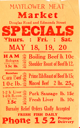
- Meat Specials! - Advertising flyer. Produced for Mayflower Meat Market, Douglas Road and Edmonds Street, Phone 152
- Object History
- Donor owned the Mayflower Meat Market.
- Maker
- Royal Press
- Country Made
- Canada
- Province Made
- British Columbia
- Site/City Made
- New Westminster
- Geographic Access
- Douglas Road
- Edmonds Street
- Historic Neighbourhood
- Edmonds (Historic Neighbourhood)
Images


advertising flyer
https://search.heritageburnaby.ca/link/museumartifact1788
- Repository
- Burnaby Village Museum
- Accession Code
- HV971.105.2
- Description
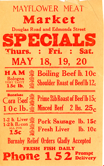
- Depednable Quality Plus Real Economy - Advertising flyer. Produced for for Mayflower Meat Market, Edmonds Street at Douglas Road; Phone 152
- Object History
- Donor owned the Mayflower Meat Market on Grandview-Douglas Highway.
- Country Made
- Canada
- Geographic Access
- Douglas Road
- Edmonds Street
- Historic Neighbourhood
- Edmonds (Historic Neighbourhood)
Images

advertising flyer
https://search.heritageburnaby.ca/link/museumartifact1789
- Repository
- Burnaby Village Museum
- Accession Code
- HV971.105.3
- Description
- Mayflower Meat Market - Advertising flyer. Produced for Mayflower Meat Market, Douglas Road and Edmonds Street; Phone 152
- Object History
- Donor owned the Mayflower Meat Market.
- Geographic Access
- Douglas Road
- Edmonds Street
- Historic Neighbourhood
- Edmonds (Historic Neighbourhood)
Images
advertising flyer
https://search.heritageburnaby.ca/link/museumartifact1790
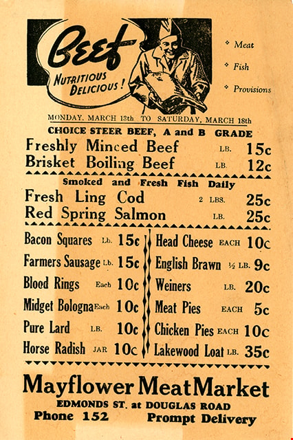
- Repository
- Burnaby Village Museum
- Accession Code
- HV971.105.4
- Description
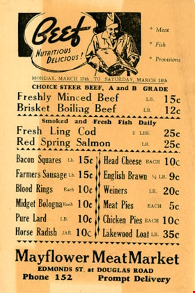
- Beef, Nutritious, Delicious! - Advertising flyer. Produced for the Mayflower Meat Market, Edmonds Street at Douglas Road; phone 152
- Object History
- Donor owned the Mayflower Meat Market.
- Geographic Access
- Douglas Road
- Edmonds Street
- Historic Neighbourhood
- Edmonds (Historic Neighbourhood)
Images
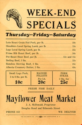
advertising flyer
https://search.heritageburnaby.ca/link/museumartifact1791
- Repository
- Burnaby Village Museum
- Accession Code
- HV971.105.5
- Description
- Week-End Specials - Advertising flyer. Produced for Mayflower Meat Market, Douglas Road and Edmonds Street; phone 152; J.A. McDonald, proprietor
- Object History
- Donor owned the Mayflower Meat Market.
- Geographic Access
- Douglas Road
- Edmonds Street
- Historic Neighbourhood
- Edmonds (Historic Neighbourhood)
Images

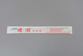
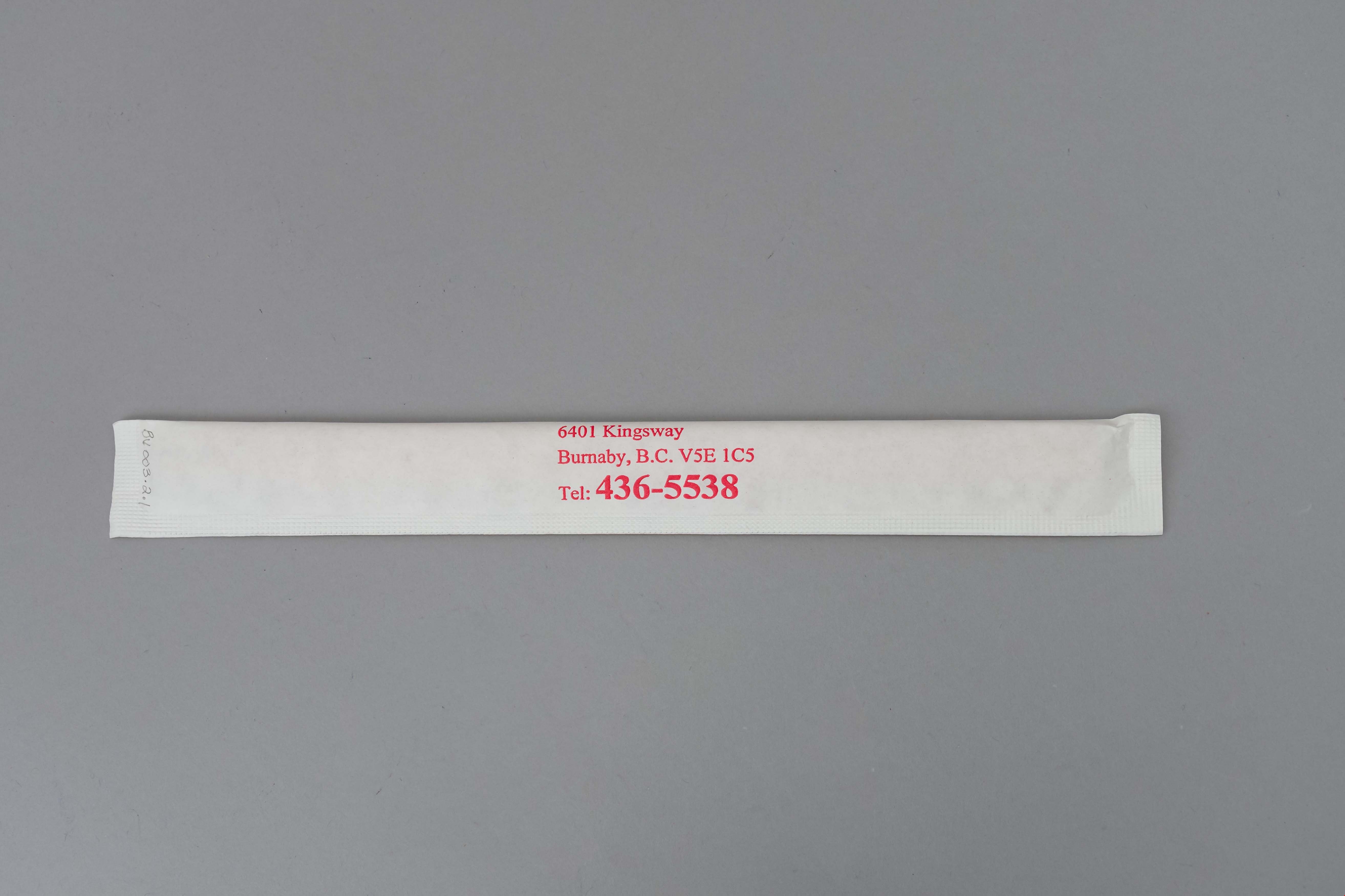
chopsticks
https://search.heritageburnaby.ca/link/museumartifact45241
- Repository
- Burnaby Village Museum
- Accession Code
- BV003.2.1
- Description
- Pair of wooden chopsticks in white paper package, from the "GRAND BUFFET RESTAURANT", 6041 Kingsway, Burnaby, B.C., V5E 1C5; "Tel: 436-5538"; all lettering in red, and Chinese characters in blue and red.
- Category
- 04.Tools & Equipment for Materials
- Classification
- Food Service T&E - - Eating & Drinking Utensils
- Object Term
- Chopsticks
- Subjects
- Persons - Chinese Canadians
- Historic Neighbourhood
- Edmonds (Historic Neighbourhood)
- Planning Study Area
- Windsor Area
Images

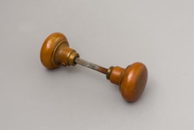
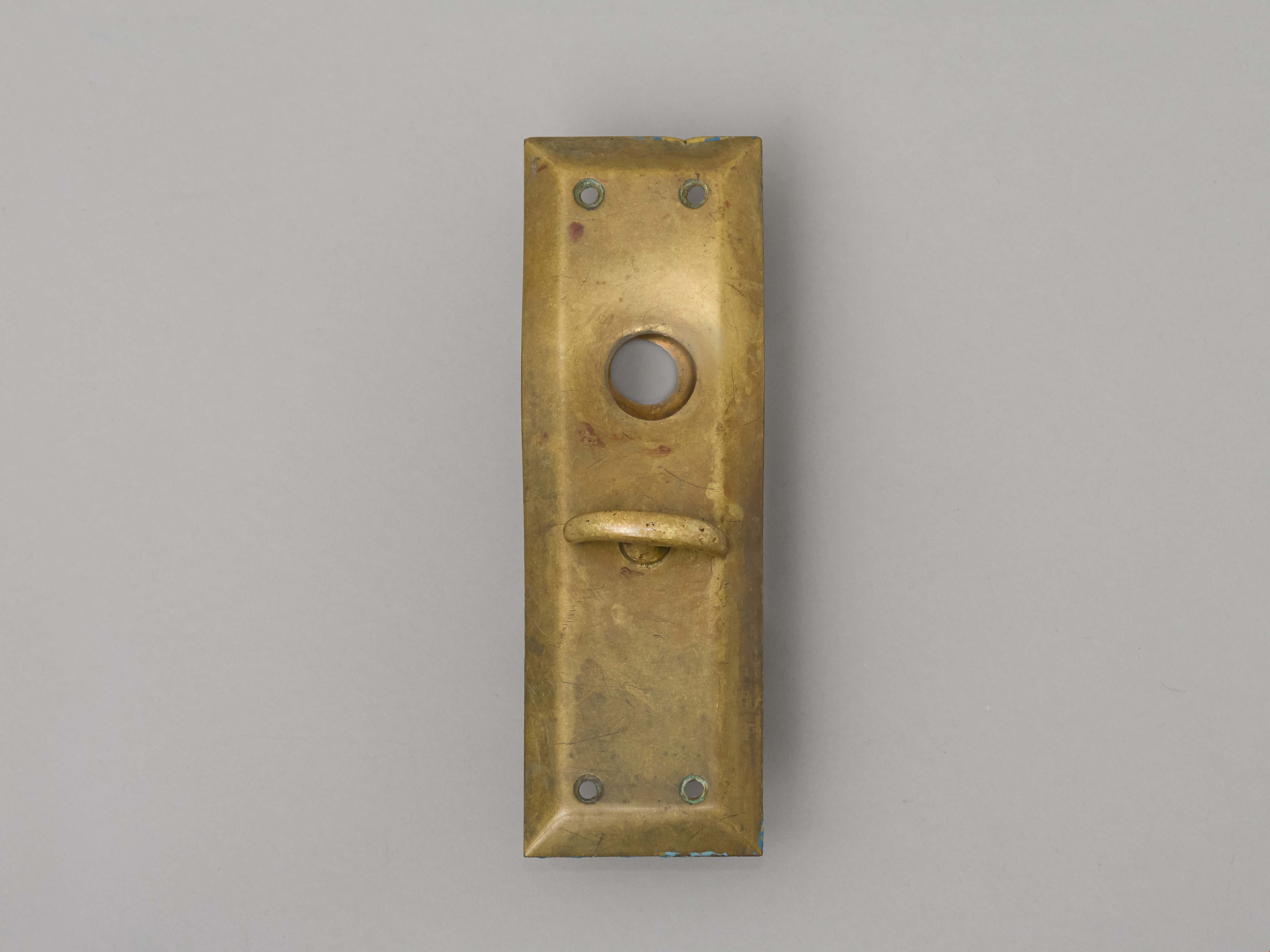
doorknob and door plate
https://search.heritageburnaby.ca/link/museumartifact84042
- Repository
- Burnaby Village Museum
- Accession Code
- BV014.34.1
- Description
- Doorknob and door plate from Edmonds School.
- Object History
- Doorknob and door plate were found in the fire remains of Edmonds School in 1989.
- Category
- 01. Built Environment Objects
- Classification
- Building Components - - Finish Hardware
- Object Term
- Doorknob
- Subjects
- Building Components
- Buildings - Schools
- Names
- Edmonds Community School
- Historic Neighbourhood
- Edmonds (Historic Neighbourhood)
- Planning Study Area
- Edmonds Area
Images

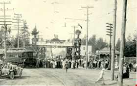
postcard
https://search.heritageburnaby.ca/link/museumartifact84670
- Repository
- Burnaby Village Museum
- Accession Code
- BV007.43.3
- Description
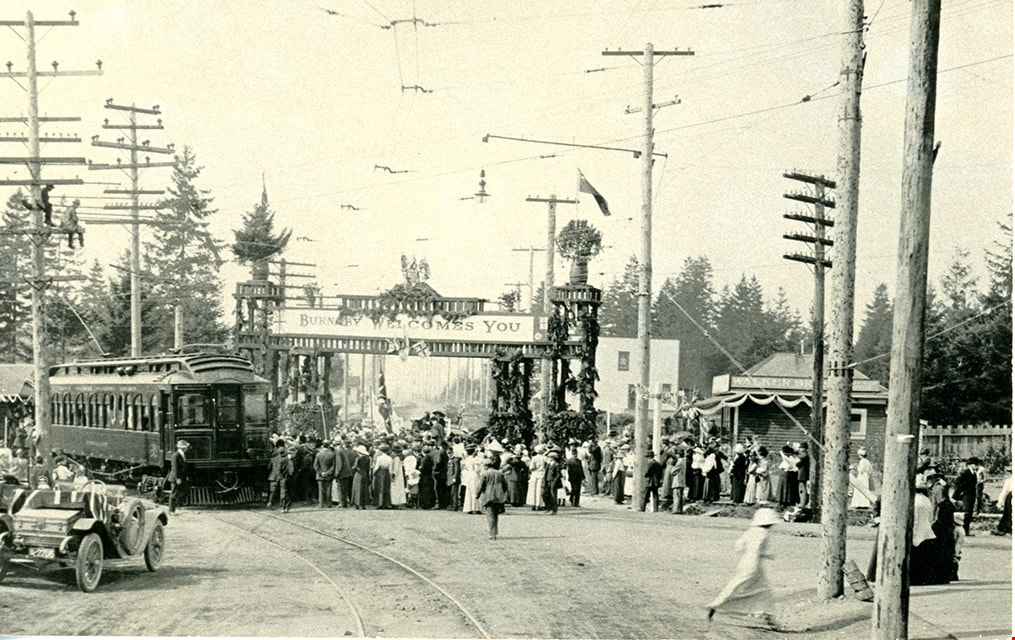
- [Duke of Connaught] - Postcard -- [1912]. Postcard with a black and white photograph of the arrival of the Duke of Connaught, then Governor General of Canada. The image was taken at Edmonds and Kingsway with a welcome arch and a banner reading "Burnaby Welcomes You". In the image there is the interurban tram and Edmonds station in the background, surrounded by many onlookers. Verso of postcard includes stamp at top reading: "CANADIAN SOUVENIR POST CARD"; divided into two sections "THIS SPACE FOR CORRESPONDENCE" / "THIS SPACE FOR ADDRESS ONLY"; includes marking to place postage stamp "POSTAGE / ONE CENT / FOR / CANADA / AND U.S. / TWO CENTS / FOR / ABROAD". Annotation in pencil on verso of postcard reads: "Sept 21 / 1912 / Duke of Connaught / at Edmonds and / Kingsway"
- Object History
- Souvenir photograph postcard documents the Duke of Connaught's visit to Burnaby in 1912.
- Classification
- Written Communication T&E - - Writing Media
- Object Term
- Postcard
- Colour
- Black
- White
- Measurements
- w: 14 cm h: 9 cm
- Geographic Access
- Edmonds Street
- Kingsway
- Historic Neighbourhood
- Edmonds (Historic Neighbourhood)
- Planning Study Area
- Richmond Park Area
Images