Narrow Results By
Subject
- Accidents 2
- Accidents - Automobile Accidents 3
- Advertising Medium 2
- Advertising Medium - Signs and Signboards 10
- Aerial Photographs 7
- Agricultural Tools and Equipment - Gardening Equipment 2
- Agriculture - Crops 1
- Agriculture - Farms 5
- Agriculture - Fruit and Berries 2
- Animals - Birds 1
- Animals - Cats 2
- Animals - Cows 3

John & Hattie Standish Residence
https://search.heritageburnaby.ca/link/landmark607
- Repository
- Burnaby Heritage Planning
- Description
- Residential building.
- Associated Dates
- c.1912
- Street View URL
- Google Maps Street View
- Repository
- Burnaby Heritage Planning
- Geographic Access
- Edmonds Street
- Associated Dates
- c.1912
- Description
- Residential building.
- Heritage Value
- This square, two-storey house displays vertical proportions, with a pyramidal roof and central dormer. It features narrow double-hung windows, lapped siding on the first storey, and shingle siding on the second divided by a belt course, and has retained a high degree of original integrity. It was built for John Albert Standish (1862-1913), a farmer who left this home to his wife, Hattie and their children after his death.
- Locality
- Edmonds
- Historic Neighbourhood
- Edmonds (Historic Neighbourhood)
- Planning Study Area
- Edmonds Area
- Area
- 367.94
- Contributing Resource
- Building
- Ownership
- Private
- Street Address
- 7408 Edmonds Street
- Street View URL
- Google Maps Street View
Images


Edmonds Neighbourhood
https://search.heritageburnaby.ca/link/landmark704
- Repository
- Burnaby Heritage Planning
- Associated Dates
- 1925-1954
- Heritage Value
- The historic growth of Edmonds as a neighbourhood was based on its strategic location on the early interurban line between Vancouver and New Westminster. Even by 1980 when a survey of the residential neighbourhoods was conducted, a full 25% of homes in the area predated 1930. The 1950s was a period of strong housing development, with both single-family and multi-family units being constructed. Although Burnaby's City Hall was moved from Kingsway and Edmonds in the early 1950s, Edmonds remained an important centre in the community.
- Historic Neighbourhood
- Edmonds (Historic Neighbourhood)
- Planning Study Area
- Stride Avenue Area
Images


East Burnaby Neighbourhood
https://search.heritageburnaby.ca/link/landmark712
- Repository
- Burnaby Heritage Planning
- Associated Dates
- 1925-1954
- Heritage Value
- After a lull in construction during the World War I period, East Burnaby Neighbourhood's growth resumed during the 1920s when many homes and businesses were constructed. The post-World War Two period also saw rapid construction and the creation of new housing developments in response to a population boom. The neighbourhood remained a primarily single-family residential area.
- Historic Neighbourhood
- Edmonds (Historic Neighbourhood)
- Planning Study Area
- Stride Avenue Area
Images


Edmonds Neighbourhood
https://search.heritageburnaby.ca/link/landmark758
- Repository
- Burnaby Heritage Planning
- Associated Dates
- 1905-1924
- Heritage Value
- From The British Columbian, March 19, 1912: "On the fringe of New Westminster there is…a suburban townsite in Edmonds. During the past eighteen months it has grown and prospered quite phenomenally. It is ideally situated, is in easy communication with New Westminster by two car lines. Its climate is clear and bracing, being exceptionally free from the fogs that are more or less prevalent along the river section and gulf shore...Edmonds, in fact, is one of the finest residential parts of the province. This is fast becoming known and appreciated beyond its borders. Elegant and substantial residences are being erected in various parts, and stores are being put up in convenient localities. The new municipal building is one of the finest in British Columbia for so young a municipality."
- Historic Neighbourhood
- Edmonds (Historic Neighbourhood)
- Planning Study Area
- Edmonds Area
Images


Burnaby South High School
https://search.heritageburnaby.ca/link/landmark770
- Repository
- Burnaby Heritage Planning
- Associated Dates
- 1922-1988
- Street View URL
- Google Maps Street View
- Repository
- Burnaby Heritage Planning
- Geographic Access
- Southoaks Crescent
- Associated Dates
- 1922-1988
- Heritage Value
- Burnaby South and Burnaby North were Burnaby's first high schools. The first rooms of the school were built in 1922 on the same grounds as the Kingsway East Elementary School. In 1940, a two-storey building was erected and additions were made in 1963, 1967 and 1972. Kingsway East closed in 1925 and its buildings were used by the high school for Industrial Arts and Home Economics. In the early 1990s, a new "urban education centre" (Burnaby South/B.C. School for the Deaf) was opened, replacing the old Burnaby South High School.
- Historic Neighbourhood
- Edmonds (Historic Neighbourhood)
- Planning Study Area
- Kingsway-Beresford Area
- Street Address
- 6650 Southoaks Crescent
- Street View URL
- Google Maps Street View
Images


Kingsway-Beresford Neighbourhood
https://search.heritageburnaby.ca/link/landmark805
- Repository
- Burnaby Heritage Planning
- Associated Dates
- 1955-2008
- Heritage Value
- Since the building boom of the 1950s, the Kingsway-Beresford Neighbourhood has maintained a residential character with the exception of the Kingsway corridor, which has become a primary commercial and light industrial sector.
- Historic Neighbourhood
- Edmonds (Historic Neighbourhood)
- Planning Study Area
- Kingsway-Beresford Area
Images


Edmonds Street Neighbourhood
https://search.heritageburnaby.ca/link/landmark827
- Repository
- Burnaby Heritage Planning
- Associated Dates
- 1955-2008
- Heritage Value
- The Edmonds Street Neighbourhood is part of the larger Edmonds Town Centre - one of four Town Centres in Burnaby. This neighbourhood is considered to be primarily residential, but a strong local commercial component developed along Edmonds and Kingsway.
- Historic Neighbourhood
- Edmonds (Historic Neighbourhood)
- Planning Study Area
- Edmonds Area
Images


Richmond Park Neighbourhood
https://search.heritageburnaby.ca/link/landmark828
- Repository
- Burnaby Heritage Planning
- Associated Dates
- 1955-2008
- Heritage Value
- The Richmond Park Neighbourhood is part of the larger Edmonds Town Centre - one of four official Town Centres in the City. Richmond Park contains a residential subdivision that developed during the 1950s as well as a strong commercial and retail centre along Edmonds and Kingsway.
- Historic Neighbourhood
- Edmonds (Historic Neighbourhood)
- Planning Study Area
- Richmond Park Area
Images


Stride Avenue Neighbourhood
https://search.heritageburnaby.ca/link/landmark845
- Repository
- Burnaby Heritage Planning
- Associated Dates
- 1955-2008
- Heritage Value
- The interurban link between New Westminster and Vancouver stimulated the early settlement of Stride Avenue. Infilling of the area took place in the early 1950s and the pace of development had slowed considerably by 1970. Duplexes became a popular feature in the decade between 1970 and 1980 and in the late 1980s, the neighbourhood was incorporated into the Edmonds Town Centre South plan.
- Historic Neighbourhood
- Edmonds (Historic Neighbourhood)
- Planning Study Area
- Stride Avenue Area
Images


Stride Hill Neighbourhood
https://search.heritageburnaby.ca/link/landmark846
- Repository
- Burnaby Heritage Planning
- Associated Dates
- 1955-2008
- Heritage Value
- The residential areas that are located within the Stride Hill Neighbourhood were primarily developed in the 1950s during Burnaby's post-war building boom. The area lying to the south of Byrne Creek Ravine Park was used as a municipal garbage dump until the 1960s and as a landfill site for yard waste disposal until the early 1990s at which point the area was incorporated into the Edmonds Town Centre Plan and the land was made into park and open space.
- Historic Neighbourhood
- Edmonds (Historic Neighbourhood)
- Planning Study Area
- Stride Hill Area
Images

![Ball thirty-three at the Inter-City Golf Driving Range, [201-] thumbnail](/media/hpo/_Data/_Archives_Images/_Unrestricted/550/557-023.jpg?width=280)
Ball thirty-three at the Inter-City Golf Driving Range
https://search.heritageburnaby.ca/link/archivedescription78772
- Repository
- City of Burnaby Archives
- Date
- [201-]
- Collection/Fonds
- Walker family fonds
- Description Level
- Item
- Physical Description
- 1 photograph (jpeg) : col. ; 314 dpi
- Scope and Content
- Photograph of "ball thirty-three" at the Inter-City Golf Driving Range in Burnaby.
- Repository
- City of Burnaby Archives
- Date
- [201-]
- Collection/Fonds
- Walker family fonds
- Physical Description
- 1 photograph (jpeg) : col. ; 314 dpi
- Description Level
- Item
- Record No.
- 557-023
- Access Restriction
- No restrictions
- Reproduction Restriction
- No restrictions
- Accession Number
- 2013-15
- Scope and Content
- Photograph of "ball thirty-three" at the Inter-City Golf Driving Range in Burnaby.
- Subjects
- Recreational Activities - Golf
- Media Type
- Photograph
- Notes
- Transcribed title
- Geographic Access
- 10th Avenue
- Historic Neighbourhood
- Edmonds (Historic Neighbourhood)
- Planning Study Area
- Edmonds Area
Images
![Ball thirty-three at the Inter-City Golf Driving Range, [201-] thumbnail](/media/hpo/_Data/_Archives_Images/_Unrestricted/550/557-023.jpg)
![Inter-City Golf Driving Range, [201-] thumbnail](/media/hpo/_Data/_Archives_Images/_Unrestricted/550/557-041.jpg?width=280)
Inter-City Golf Driving Range
https://search.heritageburnaby.ca/link/archivedescription78791
- Repository
- City of Burnaby Archives
- Date
- [201-]
- Collection/Fonds
- Walker family fonds
- Description Level
- Item
- Physical Description
- 1 photograph (jpeg) : col. ; 314 dpi
- Scope and Content
- Photograph of what appears to be ball thirty-three at the Inter-City Golf Driving Range in Burnaby.
- Repository
- City of Burnaby Archives
- Date
- [201-]
- Collection/Fonds
- Walker family fonds
- Physical Description
- 1 photograph (jpeg) : col. ; 314 dpi
- Description Level
- Item
- Record No.
- 557-041
- Access Restriction
- No restrictions
- Reproduction Restriction
- No restrictions
- Accession Number
- 2013-15
- Scope and Content
- Photograph of what appears to be ball thirty-three at the Inter-City Golf Driving Range in Burnaby.
- Subjects
- Recreational Activities - Golf
- Media Type
- Photograph
- Notes
- Title based on contents of photograph
- Geographic Access
- 10th Avenue
- Historic Neighbourhood
- Edmonds (Historic Neighbourhood)
- Planning Study Area
- Edmonds Area
Images
![Inter-City Golf Driving Range, [201-] thumbnail](/media/hpo/_Data/_Archives_Images/_Unrestricted/550/557-041.jpg)
![Gilley Brothers Logging team, [1895]. . thumbnail](/media/hpo/_Data/_Archives_Images/_Unrestricted/371/461-003.jpg?width=280)
Vancouver Road (Kingsway)
https://search.heritageburnaby.ca/link/landmark729
- Repository
- Burnaby Heritage Planning
- Associated Dates
- 1860
- Heritage Value
- The street we know as Kingsway is one of the legacies of the Royal Engineers' military defences for New Westminster. The fear of an American attack prompted the construction of the False Creek trail - later known as Vancouver Road and now Kingsway - in 1860 to connect the capital city to the ice-free salt water harbour at English Bay.
- Historic Neighbourhood
- Central Park (Historic Neighbourhood)
- Edmonds (Historic Neighbourhood)
- Planning Study Area
- Maywood Area
- Marlborough Area
- Windsor Area
- Kingsway-Beresford Area
- Stride Avenue Area
- Edmonds Area
Images
![Gilley Brothers Logging team, [1895]. . thumbnail](/media/hpo/_Data/_Archives_Images/_Unrestricted/371/461-003.jpg)
![William Brenchley house, [between 1890 and 1895] (date of original), copied 1985 thumbnail](/media/hpo/_Data/_Archives_Images/_Unrestricted/126/146-001.jpg?width=280)
William Brenchley house
https://search.heritageburnaby.ca/link/archivedescription34863
- Repository
- City of Burnaby Archives
- Date
- [between 1890 and 1895] (date of original), copied 1985
- Collection/Fonds
- Burnaby Historical Society fonds
- Description Level
- Item
- Physical Description
- 1 photograph : b&w ; 8.8 x 12.5 cm print
- Scope and Content
- Photograph of the exterior of the house of William Brenchley at 10th Avenue and Kingsway, northeast corner. A number of people are standing outside. Partially cleared land can be seen in the background.
- Repository
- City of Burnaby Archives
- Date
- [between 1890 and 1895] (date of original), copied 1985
- Collection/Fonds
- Burnaby Historical Society fonds
- Subseries
- W.E. Brenchley subseries
- Physical Description
- 1 photograph : b&w ; 8.8 x 12.5 cm print
- Description Level
- Item
- Record No.
- 146-001
- Access Restriction
- No restrictions
- Reproduction Restriction
- No known restrictions
- Accession Number
- BHS1985-16
- Scope and Content
- Photograph of the exterior of the house of William Brenchley at 10th Avenue and Kingsway, northeast corner. A number of people are standing outside. Partially cleared land can be seen in the background.
- Subjects
- Buildings - Residential - Houses
- Media Type
- Photograph
- Notes
- Title based on contents of photograph
- Geographic Access
- 10th Avenue
- Kingsway
- Historic Neighbourhood
- Edmonds (Historic Neighbourhood)
- Planning Study Area
- Edmonds Area
Images
![William Brenchley house, [between 1890 and 1895] (date of original), copied 1985 thumbnail](/media/hpo/_Data/_Archives_Images/_Unrestricted/126/146-001.jpg)
![William Brenchley farm, [between 1890 and 1895] (date of original), copied 1985 thumbnail](/media/hpo/_Data/_Archives_Images/_Unrestricted/126/146-002.jpg?width=280)
William Brenchley farm
https://search.heritageburnaby.ca/link/archivedescription34864
- Repository
- City of Burnaby Archives
- Date
- [between 1890 and 1895] (date of original), copied 1985
- Collection/Fonds
- Burnaby Historical Society fonds
- Description Level
- Item
- Physical Description
- 1 photograph : b&w ; 8.8 x 12.5 cm print
- Scope and Content
- Photograph of a farm hand and horse team inside a large stump, taken on William Brenchley's farm. The farm was located at the northeast corner of Kingsway and 10th Avenue.
- Repository
- City of Burnaby Archives
- Date
- [between 1890 and 1895] (date of original), copied 1985
- Collection/Fonds
- Burnaby Historical Society fonds
- Subseries
- W.E. Brenchley subseries
- Physical Description
- 1 photograph : b&w ; 8.8 x 12.5 cm print
- Description Level
- Item
- Record No.
- 146-002
- Access Restriction
- No restrictions
- Reproduction Restriction
- No known restrictions
- Accession Number
- BHS1985-16
- Scope and Content
- Photograph of a farm hand and horse team inside a large stump, taken on William Brenchley's farm. The farm was located at the northeast corner of Kingsway and 10th Avenue.
- Media Type
- Photograph
- Photographer
- Thompson, S.J.
- Notes
- Title based on contents of photograph
- Geographic Access
- 10th Avenue
- Kingsway
- Historic Neighbourhood
- Edmonds (Historic Neighbourhood)
- Planning Study Area
- Edmonds Area
Images
![William Brenchley farm, [between 1890 and 1895] (date of original), copied 1985 thumbnail](/media/hpo/_Data/_Archives_Images/_Unrestricted/126/146-002.jpg)

Powerhouse
https://search.heritageburnaby.ca/link/landmark731
- Repository
- Burnaby Heritage Planning
- Geographic Access
- Griffiths Avenue
- Kingsway
- Associated Dates
- 1891
- Heritage Value
- Constructed in 1891 between Edmonds and Highland Park on the Central Park Interurban Line, the steam plant provided power to run the line, then operated by Westminster and Vancouver Tramway Company. The steam powerhouse was replaced in 1905 by a B.C. Electric substation which was put into operation to receive and distribute power from the B.C.E.R. Buntzen Lake power dam. Prior to Burnaby having its own Municipal Hall, Council meetings were often held at the boarding house adjacent to the powerhouse and in 1892, Burnaby’s first Council meeting was held at the boarding house in 1892.
- Historic Neighbourhood
- Edmonds (Historic Neighbourhood)
- Planning Study Area
- Kingsway-Beresford Area
Images


East Burnaby Neighbourhood
https://search.heritageburnaby.ca/link/landmark739
- Repository
- Burnaby Heritage Planning
- Associated Dates
- 1892
- Heritage Value
- The original route of the Central Park tramline wound through New Westminster and then came up 6th Street to Edmonds, along Edmonds and across Westminster Road (Kingsway) to Highland Park and into Vancouver. Consequently, the first area of the future Municipality to attract settlers in any number was around 6th Street and Edmonds. By 1892, about 200 people had established homes in East Burnaby.
- Historic Neighbourhood
- Edmonds (Historic Neighbourhood)
- Planning Study Area
- Edmonds Area
Images

Burnaby's First Municipal Council
https://search.heritageburnaby.ca/link/archivedescription39582
- Repository
- City of Burnaby Archives
- Date
- 1892
- Collection/Fonds
- Peers Family and Hill Family fonds
- Description Level
- Item
- Physical Description
- 1 photograph : sepia ; 10 x 13.8 cm on page 21.5 x 28 cm (pasted in album)
- Scope and Content
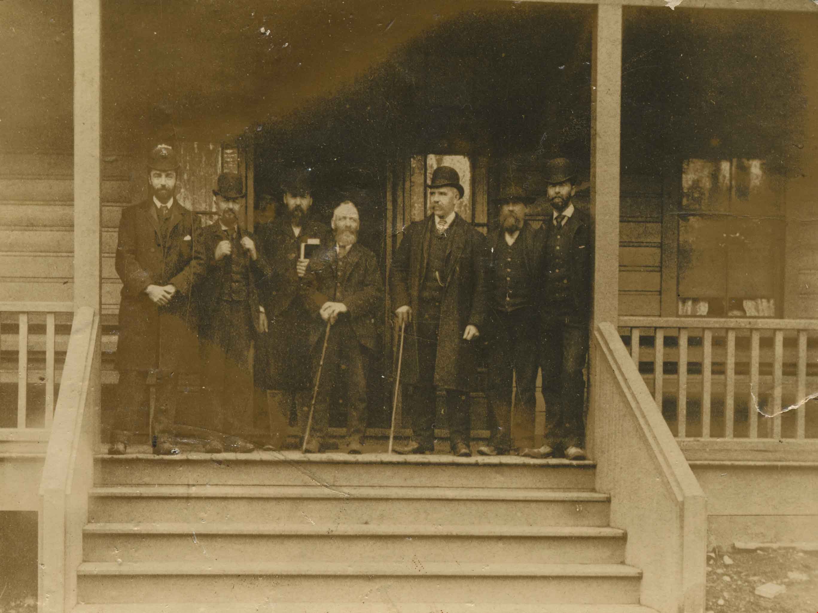
- Photograph of the first meeting of Burnaby Council, taken at the Sample Boarding House. Left to right: L.C. Hill, William Brenchley, Alex Philip (clerk), Charles R. Shaw (Reeve), William McDermott, John Woolard, and Arthur de Windt Haszard.
- Repository
- City of Burnaby Archives
- Date
- 1892
- Collection/Fonds
- Peers Family and Hill Family fonds
- Physical Description
- 1 photograph : sepia ; 10 x 13.8 cm on page 21.5 x 28 cm (pasted in album)
- Description Level
- Item
- Record No.
- 477-901
- Access Restriction
- No restrictions
- Reproduction Restriction
- No known restrictions
- Accession Number
- 2007-12
- Scope and Content
- Photograph of the first meeting of Burnaby Council, taken at the Sample Boarding House. Left to right: L.C. Hill, William Brenchley, Alex Philip (clerk), Charles R. Shaw (Reeve), William McDermott, John Woolard, and Arthur de Windt Haszard.
- Subjects
- Officials - Alderman and Councillors
- Officials - Mayors and Reeves
- Occupations - City Clerks
- Names
- Brenchley, William
- Haszard, Arthur de Windt
- Hill, Louis Claude "Claude"
- McDermott, William
- Philip, Alex
- Shaw, Charles R. "Chas"
- Woolard, John
- Media Type
- Photograph
- Notes
- Title based on contents of photograph
- Historic Neighbourhood
- Edmonds (Historic Neighbourhood)
Images

Murdock and Lillian McMurray interview November 17, 1975 - Track 1
https://search.heritageburnaby.ca/link/oralhistory243
- Repository
- City of Burnaby Archives
- Date Range
- 1892-1911
- Length
- 0:09:58
- Summary
- This portion of the recording pertains to Murdock McMurray's memories of the work that he and his brother did on the roadways; Canada Way, Kingsway. He discusses helping out at the Hatt-Cook residence as a boy as well as the tram system of the time. Lillian (Wray) McMurray is heard helping her husb…
- Repository
- City of Burnaby Archives
- Summary
- This portion of the recording pertains to Murdock McMurray's memories of the work that he and his brother did on the roadways; Canada Way, Kingsway. He discusses helping out at the Hatt-Cook residence as a boy as well as the tram system of the time. Lillian (Wray) McMurray is heard helping her husband with these descriptions.
- Date Range
- 1892-1911
- Photo Info
- Emerson Doran (left) and Murdoch McMurray, 1917. Item no. 229-004
- Length
- 0:09:58
- Subjects
- Construction - Road Construction
- Historic Neighbourhood
- Edmonds (Historic Neighbourhood)
- Interviewer
- McGeachie, Doreen “Pixie”
- Interview Date
- November 17, 1975
- Scope and Content
- Recording is of an interview with Murdock McMurray and his wife Lillian (Wray) McMurray conducted by Pixie McGeachie on November 17, 1975. Major themes discussed are: Burnaby's development, the Wray Shoe store and Murdock McMurray's cordwood delivery business.
- Biographical Notes
- Murdock McMurray was born in Vancouver in 1892 to Wilhelmina May and Robert William McMurray. Other children in the family included older siblings John “Jack” and Margaret Lillian, younger siblings Minnie May born May 4, 1895 and Hampton born June 8, 1902. Murdock’s father Robert worked for the Canadian Pacific Railway (CPR) but retired shortly after moving his family to Burnaby in 1906. He bought six acres of land of what had been previously the Gilley Ranch, the base of operations for Gilley Bros. Ltd. at 2519 Windsor Street (later renumbered and renamed to the 6400 block Imperial Street). Murdock McMurray quit school early to apprentice as a printer. By sixteen he had left the trade and gone into partnership with his older brother Jack. With a team of horses, harness and a wagon, the brothers helped to macadamize roads, haul building supplies for new homes, deliver cord wood for heating, clear land and excavate basements. When Jack McMurray set off to serve overseas during World War I as a driver in the engineer corps, Murdock bought his team of horses and continued working, mainly in the Deer Lake district. In 1916 Murdoch McMurray partnered with Emerson Doran, nephew of the owner of Doran's Mill to buy Edmonds Coal and Wood fuel yard. As everything was geared towards the war effort, Murdock and Emerson soon ran out of work and had to sell the business. Murdock sold off his horses and equipment and went to work at the ship yard on Pitt River. By 1919 Jack McMurray had returned home from overseas and was working as a fireman at the Shull Lumber and Shingle Mill on the Fraser River. In 1921, he and Murdock teamed up with Emerson Doran and repurchased the Edmonds Coal and Wood fuel yard which they ran together until 1947. Murdock McMurray married Lillian Wray on September 17, 1925. Lillian was the daughter of Mr. and Mrs. Edward Wray, who came to settle in the Jubilee area of Burnaby in 1919. The family lived on Dow Road and Edward Wray operated Jubilee Shoe Store and Post Office. He was known throughout the district as "Wray - The Shoe Man." Mrs. Wray died in 1957 at the age of eight-six and Edward Wray died January 14, 1967 at age of ninety-three. Murdock and Lillian lived at Inverness Street (now Arcola) and raised three children together, Bob, Jack and Bessie. Murdock McMurray died in New Westminster on April 28, 1985 at the age of ninety-two. Lillian Ethel (Wray) McMurray died in Burnaby on February 28, 1986 at the age of eighty-seven.
- Total Tracks
- 7
- Total Length
- 0:58:55
- Interviewee Name
- McMurray, Lillian Wray
- McMurray, Murdoch
- Interviewer Bio
- Doreen "Pixie" (Johnson) McGeachie was a resident of Burnaby for over sixty years. Pixie married John Aloysius "Jack" McGeachie and raised their children Kathi (Dunlop) and David McGeachie in the house the couple built themselves in 1947. Pixie served as the editor for the Burnaby Examiner newspaper and wrote a column entitled "Burnaby History" for The News. In 1974 she authored her first book titled "Bygones of Burnaby" which was one of the first to develop anecdotal stories about pioneer life in Burnaby. She authored "Burnaby - A Proud Century" in 1992 and in 2002 she wrote a biography of the city's namesake in the book "Land of Promise: Robert Burnaby's letters from Colonial B.C." She also contributed many hours of volunteering; helping to establish Burnaby's first museum Heritage Village in 1971, serving as President of the Burnaby Historical Society from 1991-1993. She served a six year term on Burnaby's Heritage Commission leading the charge to preserve many historic sites throughout the city, and during her twenty years as the Community Archives volunteer archivist for the historical society, she succeeded in gathering thousands of rare and valuable historic photographs and documents which now forms the core of the photograph collection on the Heritage Burnaby website (as these items were donated by the Society to the City Archives in 2007). The City of Burnaby awarded Pixie McGeachie the Kushiro Cup as Citizen of the year in 2002. In 2006 she received a Heritage BC project award for leading the Friends of Interurban 1223 project, and in 2008 Heritage BC recognised her again by presenting her with the Ruby Nobb Award. John Aloysius "Jack" McGeachie died October 12, 1981 at the age of sixty-seven. Doreen "Pixie" (Johnson) McGeachie died August 14, 2010 at the age of eighty-nine. On 24 September, 2011, the City of Burnaby dedicated the reading at the City Archives in honour of Pixie and formally named it the Pixie McGeachie Reading Room in recognition of her years of service to the community.
- Collection/Fonds
- Burnaby Historical Society fonds
- Subseries
- Oral history subseries
- Media Type
- Sound Recording
- Web Notes
- Interview was digitized in 2010 allowing it to be accessible on Heritage Burnaby. The digitization project was initiated by the Community Heritage Commission with support from City of Burnaby Council and the BC History Digitization Program of the Irving K. Barber Learning Centre, University of British Columbia. It was recognized by the Heritage Society of BC with an award in 2012.
Images

Audio Tracks
Track one of recording of interview with Lillian and Murdock McMurray
Track one of recording of interview with Lillian and Murdock McMurray
https://search.heritageburnaby.ca/media/hpo/_Data/_Archives_Oral_Histories/_Unrestricted/MSS137-010/MSS137-010_Track_1.mp3
Burnaby Council
https://search.heritageburnaby.ca/link/archivedescription34065
- Repository
- City of Burnaby Archives
- Date
- 1892
- Collection/Fonds
- Burnaby Historical Society fonds
- Description Level
- Item
- Physical Description
- 1 photograph : sepia postcard ; 9 x 11.5 cm
- Scope and Content
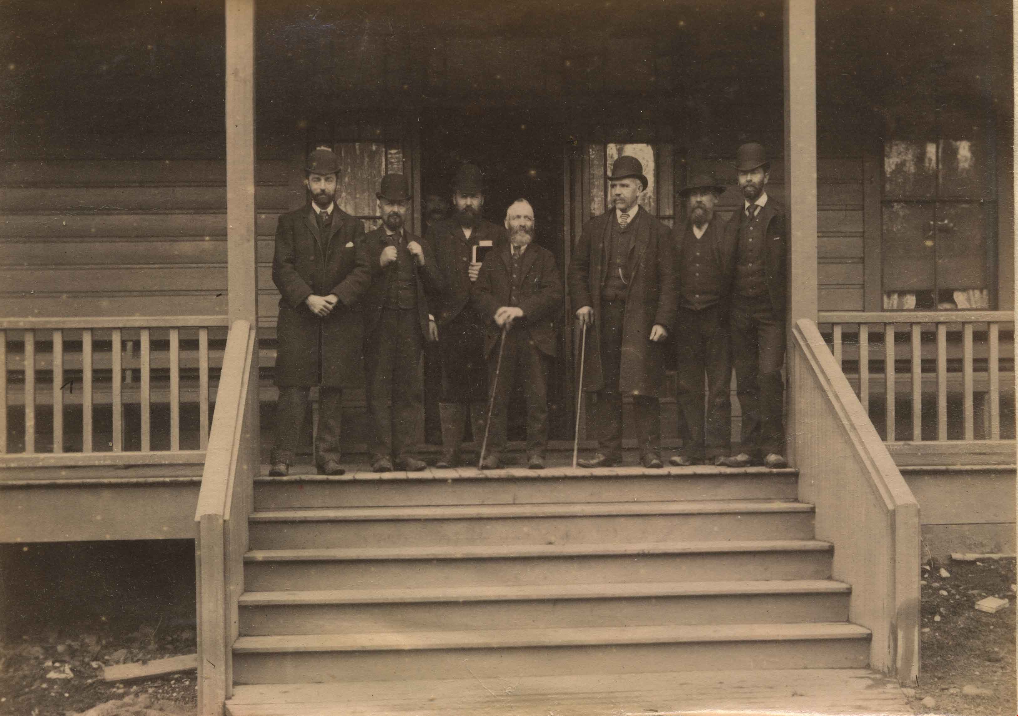
- Photograph of Burnaby's first Council members on the steps of Sample's Boarding House, 6850 Beresford Street, near Griffiths Avenue and Kingsway. Left to right: L.C. Hill, William Brenchley, Alex Philip (clerk), Charles R. Shaw (Reeve), William McDermott, John Woolard, and Arthur de Windt Haszard.
- Repository
- City of Burnaby Archives
- Date
- 1892
- Collection/Fonds
- Burnaby Historical Society fonds
- Subseries
- Photographs subseries
- Physical Description
- 1 photograph : sepia postcard ; 9 x 11.5 cm
- Description Level
- Item
- Record No.
- 008-001
- Access Restriction
- No restrictions
- Reproduction Restriction
- No known restrictions
- Accession Number
- BHS2007-04
- Scope and Content
- Photograph of Burnaby's first Council members on the steps of Sample's Boarding House, 6850 Beresford Street, near Griffiths Avenue and Kingsway. Left to right: L.C. Hill, William Brenchley, Alex Philip (clerk), Charles R. Shaw (Reeve), William McDermott, John Woolard, and Arthur de Windt Haszard.
- Names
- Brenchley, William
- Haszard, Arthur de Windt
- Hill, Louis Claude "Claude"
- McDermott, William
- Philip, Alex
- Shaw, Charles R. "Chas"
- Woolard, John
- Media Type
- Photograph
- Notes
- Title based on contents of photograph
- Geographic Access
- Beresford Street
- Street Address
- 6850 Beresford Street
- Historic Neighbourhood
- Edmonds (Historic Neighbourhood)
- Planning Study Area
- Kingsway-Beresford Area
Images