Narrow Results By
Creator
- Bowman & Cullerne 1
- Bridgman's Studio Limited 1
- British Columbia Underwriters' Association 3
- Dickie, D. J., 1883-1972 1
- Frank, Leonard 1
- Lloyd, Frank Ernest
- Lloyd's Studio 1
- Plan Department, British Columbia Insurance Underwriters' Association
- Russell Photo Studio 2
- Stride, Charles Edgar 3
- Thomson, Stuart 2
![Burnaby South High School, [1925] thumbnail](/media/hpo/_Data/_BVM_Images/1972/1972_0200_0001_001.jpg?width=280)
Burnaby South High School
https://search.heritageburnaby.ca/link/museumdescription1106
- Repository
- Burnaby Village Museum
- Date
- [1925]
- Collection/Fonds
- Burnaby Village Museum Photograph collection
- Description Level
- Item
- Physical Description
- 1 photograph : b&w ; 17.7 x 12.7 cm
- Scope and Content
- Photograph of an unidentified class of teenaged girls and a female teacher. They are standing on the stairs or sitting on chairs laid out in front of the stairs to a double door to the school. The teacher is sitting on the right side of the photograph in the front row. All the girls have short hai…
- Repository
- Burnaby Village Museum
- Collection/Fonds
- Burnaby Village Museum Photograph collection
- Description Level
- Item
- Physical Description
- 1 photograph : b&w ; 17.7 x 12.7 cm
- Scope and Content
- Photograph of an unidentified class of teenaged girls and a female teacher. They are standing on the stairs or sitting on chairs laid out in front of the stairs to a double door to the school. The teacher is sitting on the right side of the photograph in the front row. All the girls have short hair, either parted and straight or bobbed. They are wearing loose fitting dresses with stockings. Some have scarves, ties and/or beads. The inscription and the signed gift form from the donor identify the photograph as a class at Burnaby South Highschool, from 1925. Inscribed on the negative and printed on the lower left of the photo: "#6." Annotated on the back of the photo: "1925 / B South." Stamped on the back of the photo: "Lloyd's Studio / 3966 Kingsway / McKay, B.C. Carl. 343R2."
- Subjects
- Occupations - Teachers
- Geographic Access
- Southoaks Crescent
- Street Address
- 6650 Southoaks Crescent
- Accession Code
- HV972.200.1
- Access Restriction
- No restrictions
- Reproduction Restriction
- May be restricted by third party rights
- Date
- [1925]
- Media Type
- Photograph
- Historic Neighbourhood
- Edmonds (Historic Neighbourhood)
- Planning Study Area
- Kingsway-Beresford Area
- Scan Resolution
- 600
- Scan Date
- 2023-04-18
- Photographer
- Lloyd, Frank Ernest
- Notes
- Title based on contents of photograph
Images
![Burnaby South High School, [1925] thumbnail](/media/hpo/_Data/_BVM_Images/1972/1972_0200_0001_001.jpg)

Municipality of Burnaby- Volume XV and Volume XVIII
https://search.heritageburnaby.ca/link/museumdescription8686
- Repository
- Burnaby Village Museum
- Date
- May 1927
- Collection/Fonds
- Burnaby Village Museum Map collection
- Description Level
- File
- Physical Description
- 4 plans on 4 sheets : col. lithographic prints ; 63.5 x 53.5 cm folded to 53 x 31.5 cm
- Scope and Content
- File consists of four pages of plans removed from a bound book containing a series of fire insurance plans of the Municipality of Burnaby. Plan "1520" is part of "GREATER VANCOUVER B.C. / VOLUME XV / Municipality of Burnaby / May 1927" and covers District Lots: 121 and 187. Plann "1521" is part of …
- Repository
- Burnaby Village Museum
- Collection/Fonds
- Burnaby Village Museum Map collection
- Description Level
- File
- Physical Description
- 4 plans on 4 sheets : col. lithographic prints ; 63.5 x 53.5 cm folded to 53 x 31.5 cm
- Material Details
- Scale [1:600] and [1:1200]
- Scope and Content
- File consists of four pages of plans removed from a bound book containing a series of fire insurance plans of the Municipality of Burnaby. Plan "1520" is part of "GREATER VANCOUVER B.C. / VOLUME XV / Municipality of Burnaby / May 1927" and covers District Lots: 121 and 187. Plann "1521" is part of "GREATER VANCOUVER B.C. / VOLUME XV / Municipality of Burnaby / May 1927" and covers District Lots: 121 and 187. Key plan "H" reads: "GREATER VANCOUVER B.C. / VOLUME XVIII / Surveyed _ May 1927 / MUNICIPALITY OF / BURNABY" and covers plans: 1813 to 1822; 1824 to 1832; 1839; 1840; 1853 to 1865 and District Lots: 28; 30; 53; 90 to 93; 95 to 97; 155a; 155b; 155c; 159; 160; 171 to 173. Plan "1801" is part of "GREATER VANCOUVER B.C. / VOLUME XVIII / Municipality of Burnaby / May 1927" and covers District Lot 153.
- Responsibility
- British Columbia Underwriters' Association
- Accession Code
- HV972.111.8
- Access Restriction
- No restrictions
- Reproduction Restriction
- May be restricted by third party rights
- Date
- May 1927
- Media Type
- Cartographic Material
- Historic Neighbourhood
- Fraser Arm (Historic Neighbourhood)
- Vancouver Heights (Historic Neighbourhood)
- East Burnaby (Historic Neighbourhood)
- Edmonds (Historic Neighbourhood)
- Planning Study Area
- Marlborough Area
- Kingsway-Beresford Area
- Windsor Area
- Big Bend Area
- Clinton-Glenwood Area
- Burnaby Heights Area
- Edmonds Area
- Stride Avenue Area
- Scan Resolution
- 400
- Scan Date
- 2021-11-18
- Notes
- Title based on content of plans
- See also BV987.1.70d for revised versions of plans
- Scale is measured 1 inch = 500 feet
Zoomable Images


Municipality of Burnaby - Volume XVIII
https://search.heritageburnaby.ca/link/museumdescription8687
- Repository
- Burnaby Village Museum
- Date
- May 1927
- Collection/Fonds
- Burnaby Village Museum Map collection
- Description Level
- File
- Physical Description
- 2 plans on 2 sheets : col. lithographic prints; 63.5 x 53.5 cm folded to 53 x 31.5 cm
- Scope and Content
- File consists of two pages of plans removed from a bound book containing a series of fire insurance plans of the Municipality of Burnaby. Plan "1819" and Plan "1820 are part of "GREATER VANCOUVER B.C. / VOLUME XVIII / Municipality of Burnaby / May 1927. Plan "1819" covers District Lot 95 and plan …
- Repository
- Burnaby Village Museum
- Collection/Fonds
- Burnaby Village Museum Map collection
- Description Level
- File
- Physical Description
- 2 plans on 2 sheets : col. lithographic prints; 63.5 x 53.5 cm folded to 53 x 31.5 cm
- Material Details
- Scales [1:600]
- Scope and Content
- File consists of two pages of plans removed from a bound book containing a series of fire insurance plans of the Municipality of Burnaby. Plan "1819" and Plan "1820 are part of "GREATER VANCOUVER B.C. / VOLUME XVIII / Municipality of Burnaby / May 1927. Plan "1819" covers District Lot 95 and plan "1820" covers District Lots 30 and 95.
- Responsibility
- British Columbia Underwriters' Association
- Accession Code
- HV972.111.38
- Access Restriction
- No restrictions
- Reproduction Restriction
- May be restricted by third party rights
- Date
- May 1927
- Media Type
- Cartographic Material
- Historic Neighbourhood
- Edmonds (Historic Neighbourhood)
- Highland Park (Historic Neighbourhood)
- Planning Study Area
- Stride Hill Area
- Kingsway-Beresford Area
- Scan Resolution
- 400
- Scan Date
- 2021-11-18
- Notes
- Title based on content of plans
- Scales are measured 1 inch = 50 feet
- See also BV987.1.70d for revised versions of plans
Images


Municipality of Burnaby - Volume XV, Volume XVI, Volume XVII, Volume XVIII
https://search.heritageburnaby.ca/link/museumdescription8685
- Repository
- Burnaby Village Museum
- Date
- May 1927
- Collection/Fonds
- Burnaby Village Museum Map collection
- Description Level
- File
- Physical Description
- 4 plans on 4 sheets : col. lithographic prints ; 63.5 x 53.5 cm folded to 53 x 31.5 cm
- Scope and Content
- File consists of four pages of plans removed from a bound book containing a series of fire insurance plans of the Municipality of Burnaby. Plan "1531" is part of "GREATER VANCOUVER B.C. / VOLUME XV / Municipality of Burnaby / May 1927" and covers District Lots: 116 and 117. Key Plan "C" is part of …
- Repository
- Burnaby Village Museum
- Collection/Fonds
- Burnaby Village Museum Map collection
- Description Level
- File
- Physical Description
- 4 plans on 4 sheets : col. lithographic prints ; 63.5 x 53.5 cm folded to 53 x 31.5 cm
- Material Details
- Scale [1:600] and [1:1200]
- Scope and Content
- File consists of four pages of plans removed from a bound book containing a series of fire insurance plans of the Municipality of Burnaby. Plan "1531" is part of "GREATER VANCOUVER B.C. / VOLUME XV / Municipality of Burnaby / May 1927" and covers District Lots: 116 and 117. Key Plan "C" is part of "GREATER VANCOUVER B.C. / VOLUME XVI / Municipality of Burnaby / May 1927" and covers plans 1623 to 1651 and District Lots: 1 and 2; 4; 6; 8; 10 to 14; 25; 27; 40; 56 to 58; 88 and 89. Plan "1738" is part of "GREATER VANCOUVER B.C. / VOLUME XVII / Municipality of Burnaby / May 1927" and covers District Lots: 34 and 35. Key plan "G" is part of "GREATER VANCOUVER B.C. / VOLUME XVIII / Municipality of Burnaby / May 1927" and covers plans: 1801 to 1813; 1823; 1824; 1833 to 1838; 1841 to 1853 and District Lots: 32; 93; 94; 97 to 99; 149; 150; 152; 155 to 159; 161 to 164.
- Responsibility
- British Columbia Underwriters' Association
- Accession Code
- HV972.111.7
- Access Restriction
- No restrictions
- Reproduction Restriction
- May be restricted by third party rights
- Date
- May 1927
- Media Type
- Cartographic Material
- Historic Neighbourhood
- Central Park (Historic Neighbourhood)
- Fraser Arm (Historic Neighbourhood)
- Alta Vista (Historic Neighbourhood)
- Broadview (Historic Neighbourhood)
- Vancouver Heights (Historic Neighbourhood)
- Burquitlam (Historic Neighbourhood)
- East Burnaby (Historic Neighbourhood)
- Edmonds (Historic Neighbourhood)
- Lozells (Historic Neighbourhood)
- Planning Study Area
- Clinton-Glenwood Area
- Marlborough Area
- Maywood Area
- Windsor Area
- Big Bend Area
- Garden Village Area
- Willingdon Heights Area
- West Central Valley Area
- Cariboo-Armstrong Area
- Lyndhurst Area
- Cameron Area
- Lake City Area
- Edmonds Area
- Second Street Area
- Sperling-Broadway Area
- Lakeview-Mayfield Area
- Scan Resolution
- 400
- Scan Date
- 2021-11-18
- Notes
- Title based on content of plans
- See also BV987.1.70d for revised versions of plans
- Scale is measured 1 inch = 500 feet
Zoomable Images

Municipality of Burnaby - Volume XV, Volume XVI, Volume XVII, Volume XVIII, May 1927
Zoom into Image

Reception for Governor-General Lord Willingdon
https://search.heritageburnaby.ca/link/museumdescription530
- Repository
- Burnaby Village Museum
- Date
- May 2, 1928
- Collection/Fonds
- Hawkshaw family fonds
- Description Level
- Item
- Physical Description
- 1 photograph : sepia ; 11 x 16 cm
- Scope and Content
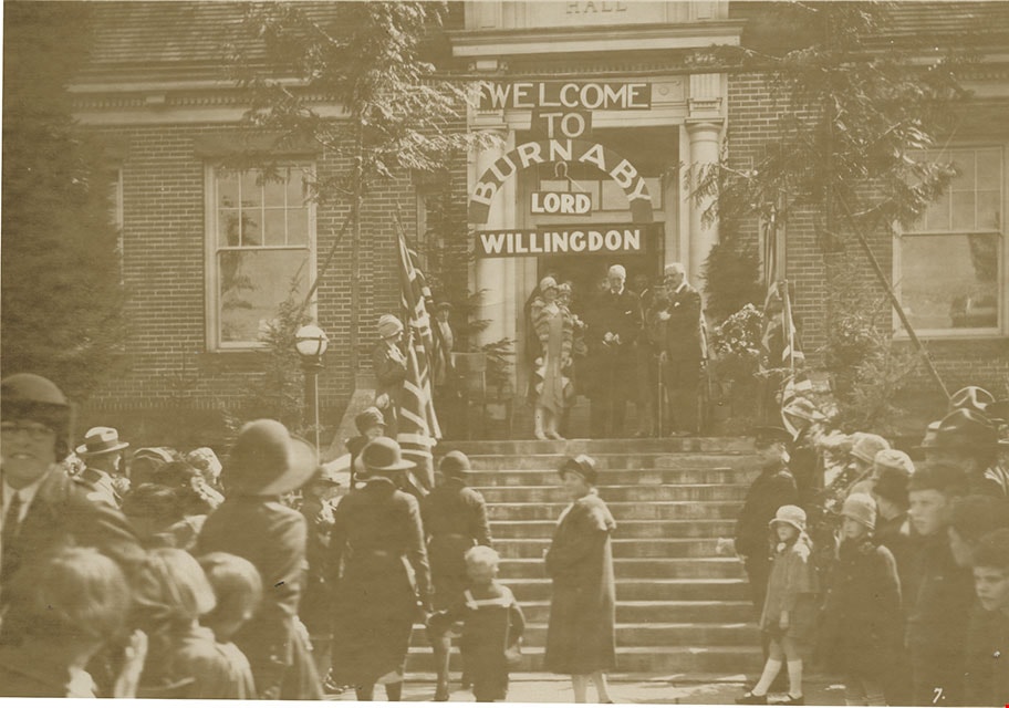
- Photograph of the visit of Lord Willingdon to Burnaby at the Municipal Hall in 1928. Along the steps leading to the main entrance, are women in ranger uniforms holding Union Jacks on poles. Lord Willingdon and other dignitaries are standing in front of the entrance. The doorway is decorated with a …
- Repository
- Burnaby Village Museum
- Collection/Fonds
- Hawkshaw family fonds
- Description Level
- Item
- Physical Description
- 1 photograph : sepia ; 11 x 16 cm
- Scope and Content
- Photograph of the visit of Lord Willingdon to Burnaby at the Municipal Hall in 1928. Along the steps leading to the main entrance, are women in ranger uniforms holding Union Jacks on poles. Lord Willingdon and other dignitaries are standing in front of the entrance. The doorway is decorated with a sign that reads, "Welcome to Burnaby Lord Willingdon." Mabel Hawkshaw is holding hands with her son Cedric as they walk towards the stairs.
- Subjects
- Events - Visits of State
- Events - Royal Visits
- Officials - Governor Generals
- Symbols - Flags
- Clothing - Uniforms
- Names
- Hawkshaw, Merton Cedric Perry "Cedric"
- Hawkshaw, Mabel Edith Honor McClean
- Willingdon, Lord, 1866-1941
- Geographic Access
- Kingsway
- Street Address
- 7282 Kingsway
- Accession Code
- HV977.17.15
- Access Restriction
- No restrictions
- Reproduction Restriction
- No known restrictions
- Date
- May 2, 1928
- Media Type
- Photograph
- Historic Neighbourhood
- Edmonds (Historic Neighbourhood)
- Planning Study Area
- Stride Avenue Area
- Related Material
- For another photograph of the visit of Lord Willingdon at Burnaby Municipal Hall, see BV985.3137.8
- Scan Resolution
- 600
- Scan Date
- 2023-07-04
- Scale
- 100
- Photographer
- Lloyd, Frank Ernest
- Notes
- Title based on contents of photograph
- 1 b&w copy negative accompanying
- Annotation on verso of the photograph reads: "Mrs. John E. Hawkshaw in Ranger uniform leading son Cedric in sailor suit by the hand."
- Second annotation reads: "Here I go up with Ceddie to be 'presented' for the 'third' time! Previously twice in other orders."
- Stamp on the verso of photograph reads: "Lloyd's Studio / 3966 Kingsway / McKay, B.C. Carl. 343R2."
Images
Welcome to Burnaby Lord Willingdon
https://search.heritageburnaby.ca/link/museumdescription238
- Repository
- Burnaby Village Museum
- Date
- 1928
- Collection/Fonds
- Burnaby Village Museum Photograph collection
- Description Level
- Item
- Physical Description
- 1 photograph : b&w print
- Scope and Content
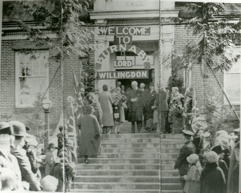
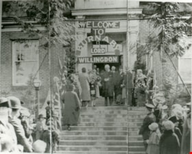
- Photograph of Burnaby Municipal Hall decorated for the visit of Lord Willingdon in 1928. Along the steps leading to the main entrance are women in ranger uniforms holding Union Jacks on poles. Lord Willingdon and other dignitaries are standing in front of the entrance. The doorway is decorated with…
- Repository
- Burnaby Village Museum
- Collection/Fonds
- Burnaby Village Museum Photograph collection
- Description Level
- Item
- Physical Description
- 1 photograph : b&w print
- Scope and Content
- Photograph of Burnaby Municipal Hall decorated for the visit of Lord Willingdon in 1928. Along the steps leading to the main entrance are women in ranger uniforms holding Union Jacks on poles. Lord Willingdon and other dignitaries are standing in front of the entrance. The doorway is decorated with a sign that reads, "WELCOME TO BURNABY LORD WILLINGDON" There is a woman climbing up the steps towards Lord Willingdon. Lord Willingdon was Canada's Governor General at that time. The photographer is speculated to be Lloyd studio, because of the similarity with the photograph HV977.17.15 of Lord Willingdon's visit by Lloyd studio
- Geographic Access
- Kingsway
- Street Address
- 7282 Kingsway
- Accession Code
- BV985.3137.8
- Reproduction Restriction
- May be restricted by third party rights
- Date
- 1928
- Media Type
- Photograph
- Historic Neighbourhood
- Edmonds (Historic Neighbourhood)
- Planning Study Area
- Stride Avenue Area
- Related Material
- For another photograph of the visit of Lord Willingdon at Burnaby Municipal Hall, see HV977.17.15
- Scan Resolution
- 600
- Scan Date
- 2024-02-02
- Photographer
- Lloyd, Frank Ernest
- Notes
- Title based on contents of photograph
- 1 b&w copy negative accompanying
Images