Narrow Results By
![At Buena Vista, [between 1912 and 1925] thumbnail](/media/hpo/_Data/_BVM_Images/1984/1984_0051_0032_001.jpg?width=280)
At Buena Vista
https://search.heritageburnaby.ca/link/museumdescription260
- Repository
- Burnaby Village Museum
- Date
- [between 1912 and 1925]
- Collection/Fonds
- Burnaby Village Museum Photograph collection
- Description Level
- Item
- Physical Description
- 1 photograph : b&w ; 3.5 x 7.0 cm
- Scope and Content
- Photograph of a woman with short dark hair wearing a white blouse, sitting on the steps of a house. According to the accession register, the location of the house is at Buena Vista, Burnaby, between 1912 and 1925.
- Repository
- Burnaby Village Museum
- Collection/Fonds
- Burnaby Village Museum Photograph collection
- Description Level
- Item
- Physical Description
- 1 photograph : b&w ; 3.5 x 7.0 cm
- Scope and Content
- Photograph of a woman with short dark hair wearing a white blouse, sitting on the steps of a house. According to the accession register, the location of the house is at Buena Vista, Burnaby, between 1912 and 1925.
- Accession Code
- HV984.51.32
- Access Restriction
- No restrictions
- Reproduction Restriction
- No known restrictions
- Date
- [between 1912 and 1925]
- Media Type
- Photograph
- Historic Neighbourhood
- East Burnaby (Historic Neighbourhood)
- Planning Study Area
- Cariboo-Armstrong Area
- Scan Resolution
- 600
- Scan Date
- 2023-10-10
- Notes
- Title based on contents of photograph
Images
![At Buena Vista, [between 1912 and 1925] thumbnail](/media/hpo/_Data/_BVM_Images/1984/1984_0051_0032_001.jpg)
Copies of Esther (Love) Stanley photograph album pages
https://search.heritageburnaby.ca/link/museumdescription10013
- Repository
- Burnaby Village Museum
- Date
- [1910-1930] (date of originals), copied 1989
- Collection/Fonds
- Burnaby Village Museum fonds
- Description Level
- File
- Physical Description
- 26 photographs : b&w negatives ; 35 mm
- Scope and Content
- Photographs of pages from a photograph album belonging to Esther (Love) Stanley. Each photograph includes five to seven images per page as per the arrangement of the original album.
- Repository
- Burnaby Village Museum
- Collection/Fonds
- Burnaby Village Museum fonds
- Series
- Jesse Love farmhouse series
- Subseries
- Love family photographs subseries
- Description Level
- File
- Physical Description
- 26 photographs : b&w negatives ; 35 mm
- Scope and Content
- Photographs of pages from a photograph album belonging to Esther (Love) Stanley. Each photograph includes five to seven images per page as per the arrangement of the original album.
- Subjects
- Buildings - Heritage
- Geographic Access
- Cumberland Street
- Street Address
- 7651 Cumberland Street
- Accession Code
- BV018.41.193
- Access Restriction
- No restrictions
- Reproduction Restriction
- May be restricted by third party rights
- Date
- [1910-1930] (date of originals), copied 1989
- Media Type
- Photograph
- Historic Neighbourhood
- East Burnaby (Historic Neighbourhood)
- Planning Study Area
- Cariboo-Armstrong Area
- Notes
- Title based on contents of photograph
- 26 b&w copy prints accompanying
Copies of Esther (Love) Stanley photograph album pages
https://search.heritageburnaby.ca/link/museumdescription10015
- Repository
- Burnaby Village Museum
- Date
- [1900-1930] (date of originals), copied 1988
- Collection/Fonds
- Burnaby Village Museum fonds
- Description Level
- File
- Physical Description
- 25 photographs : b&w negatives ; 35 mm
- Scope and Content
- Photographs of pages from a photograph album belonging to Esther (Love) Stanley. Each photograph includes five to nine images per page as per the arrangement of the original album.
- Repository
- Burnaby Village Museum
- Collection/Fonds
- Burnaby Village Museum fonds
- Series
- Jesse Love farmhouse series
- Subseries
- Love family photographs subseries
- Description Level
- File
- Physical Description
- 25 photographs : b&w negatives ; 35 mm
- Scope and Content
- Photographs of pages from a photograph album belonging to Esther (Love) Stanley. Each photograph includes five to nine images per page as per the arrangement of the original album.
- Subjects
- Buildings - Heritage
- Geographic Access
- Cumberland Street
- Street Address
- 7651 Cumberland Street
- Accession Code
- BV018.41.194
- Access Restriction
- No restrictions
- Reproduction Restriction
- May be restricted by third party rights
- Date
- [1900-1930] (date of originals), copied 1988
- Media Type
- Photograph
- Historic Neighbourhood
- East Burnaby (Historic Neighbourhood)
- Planning Study Area
- Cariboo-Armstrong Area
- Notes
- Title based on contents of photograph
- 21 b&w copy prints accompanying
Copies of Esther (Love) Stanley photograph album pages
https://search.heritageburnaby.ca/link/museumdescription10016
- Repository
- Burnaby Village Museum
- Date
- [1900-1930] (date of originals), copied 1989
- Collection/Fonds
- Burnaby Village Museum fonds
- Description Level
- File
- Physical Description
- 37 photographs : b&w negatives ; 35 mm
- Scope and Content
- Photographs of pages from a photograph album belonging to Esther (Love) Stanley. Each photograph includes one to four images per page as per the arrangement of the original album.
- Repository
- Burnaby Village Museum
- Collection/Fonds
- Burnaby Village Museum fonds
- Series
- Jesse Love farmhouse series
- Subseries
- Love family photographs subseries
- Description Level
- File
- Physical Description
- 37 photographs : b&w negatives ; 35 mm
- Scope and Content
- Photographs of pages from a photograph album belonging to Esther (Love) Stanley. Each photograph includes one to four images per page as per the arrangement of the original album.
- Subjects
- Buildings - Heritage
- Geographic Access
- Cumberland Street
- Street Address
- 7651 Cumberland Street
- Accession Code
- BV018.41.195
- Access Restriction
- No restrictions
- Reproduction Restriction
- May be restricted by third party rights
- Date
- [1900-1930] (date of originals), copied 1989
- Media Type
- Photograph
- Historic Neighbourhood
- East Burnaby (Historic Neighbourhood)
- Planning Study Area
- Cariboo-Armstrong Area
- Notes
- Title based on contents of photograph
- 39 b&w copy prints accompanying (two copy prints are close ups from negatives)
Copies of photographs from Esther (Love) Stanley albums
https://search.heritageburnaby.ca/link/museumdescription10003
- Repository
- Burnaby Village Museum
- Date
- [1915-1950] (date of originals), copied 1989
- Collection/Fonds
- Burnaby Village Museum fonds
- Description Level
- File
- Physical Description
- 36 photographs : b&w negatives ; 35 mm
- Scope and Content
- Photographs copied from various photograph albums including; Albert Paker, George Love, Gordon Love and Esther (Love) Stanley. Content includes: Love family in front of the piano inside parlour; Love family members with musical instruments inside parlour; Ben Brandrith and Robert Love in uniforms; …
- Repository
- Burnaby Village Museum
- Collection/Fonds
- Burnaby Village Museum fonds
- Series
- Jesse Love farmhouse series
- Subseries
- Love family photographs subseries
- Description Level
- File
- Physical Description
- 36 photographs : b&w negatives ; 35 mm
- Scope and Content
- Photographs copied from various photograph albums including; Albert Paker, George Love, Gordon Love and Esther (Love) Stanley. Content includes: Love family in front of the piano inside parlour; Love family members with musical instruments inside parlour; Ben Brandrith and Robert Love in uniforms; unidentified Asian man in field with hoe and young trees behind him; wedding cake from Frank Charles Stanley and Esther Love's wedding; land clearing for Love farmhouse; Jesse Love feeding chickens; Jesse and Hannah (Girlie) Love in hats outside on Love farm; large picnic on grass; four generations of Love family members; gatherings of Love family members outside; Love family posed in a car inside a studio (Will, Sarah, George, Phoebe and Martha); Leonard Love dressed as a boy scout; Martha (Dot) with children; Love family members celebrate centennial; Jesse Love and Martha (Dot) Love outside Love farmhouse; Love farmhouse with porch and garden; swing at Love farmhouse; Parker family in living room and view of the Love farmhouse from the front.
- Geographic Access
- Cumberland Street
- Street Address
- 7651 Cumberland Street
- Accession Code
- BV018.41.184
- Access Restriction
- No restrictions
- Reproduction Restriction
- May be restricted by third party rights
- Date
- [1915-1950] (date of originals), copied 1989
- Media Type
- Photograph
- Historic Neighbourhood
- East Burnaby (Historic Neighbourhood)
- Planning Study Area
- Cariboo-Armstrong Area
- Scan Date
- 4-Mar-2019
- Notes
- Title based on contents of photograph
- 36 b&w copy prints accompanying
![Emily at Buena Vista, [between 1912 and 1925] thumbnail](/media/hpo/_Data/_BVM_Images/1984/1984_0051_0020_001.jpg?width=280)
Emily at Buena Vista
https://search.heritageburnaby.ca/link/museumdescription248
- Repository
- Burnaby Village Museum
- Date
- [between 1912 and 1925]
- Collection/Fonds
- Burnaby Village Museum Photograph collection
- Description Level
- Item
- Physical Description
- 1 photograph : sepia ; 11.5 x 7.0 cm
- Scope and Content
- Photograph of a middle aged woman standing in front of a house. She is wearing a shirt with flower emboridering at the bottom left hand corner with a long pleated skirt, and a hat. The annotation on the back of the photograph identifies her as "Emily." According to the accession register, the loca…
- Repository
- Burnaby Village Museum
- Collection/Fonds
- Burnaby Village Museum Photograph collection
- Description Level
- Item
- Physical Description
- 1 photograph : sepia ; 11.5 x 7.0 cm
- Scope and Content
- Photograph of a middle aged woman standing in front of a house. She is wearing a shirt with flower emboridering at the bottom left hand corner with a long pleated skirt, and a hat. The annotation on the back of the photograph identifies her as "Emily." According to the accession register, the location of the house is at Buena Vista, Burnaby, between 1912 and 1925. Stamped on the back of the photograph: "Better Pictures / NuGloss / Photo Finish / Vancouver Drug Co."
- Accession Code
- HV984.51.20
- Access Restriction
- No restrictions
- Reproduction Restriction
- No known restrictions
- Date
- [between 1912 and 1925]
- Media Type
- Photograph
- Historic Neighbourhood
- East Burnaby (Historic Neighbourhood)
- Planning Study Area
- Cariboo-Armstrong Area
- Related Material
- For another photograph of the woman identified as Emily in this accession, see HV984.51.22
- Scan Resolution
- 600
- Scan Date
- 2023-10-10
- Notes
- Title based on contents of photograph
Images
![Emily at Buena Vista, [between 1912 and 1925] thumbnail](/media/hpo/_Data/_BVM_Images/1984/1984_0051_0020_001.jpg)
![Girl in gateway, [between 1912 and 1925] thumbnail](/media/hpo/_Data/_BVM_Images/1984/1984_0051_0028_001.jpg?width=280)
Girl in gateway
https://search.heritageburnaby.ca/link/museumdescription256
- Repository
- Burnaby Village Museum
- Date
- [between 1912 and 1925]
- Collection/Fonds
- Burnaby Village Museum Photograph collection
- Description Level
- Item
- Physical Description
- 1 photograph : b&w ; 9.8 x 7.2 cm
- Scope and Content
- Photograph of a girl in a dress tied at the waist with a white collar at the neck. She is wearing boots and a straw hat, and is standing by the gateway in a log fence. There is a cobblestone path way on which she is standing, and there are woods in the distance in the background. According to the a…
- Repository
- Burnaby Village Museum
- Collection/Fonds
- Burnaby Village Museum Photograph collection
- Description Level
- Item
- Physical Description
- 1 photograph : b&w ; 9.8 x 7.2 cm
- Scope and Content
- Photograph of a girl in a dress tied at the waist with a white collar at the neck. She is wearing boots and a straw hat, and is standing by the gateway in a log fence. There is a cobblestone path way on which she is standing, and there are woods in the distance in the background. According to the accession register, the location is at Buena Vista, Burnaby, between 1912 and 1925.
- Subjects
- Structures - Fences
- Accession Code
- HV984.51.28
- Access Restriction
- No restrictions
- Reproduction Restriction
- No known restrictions
- Date
- [between 1912 and 1925]
- Media Type
- Photograph
- Historic Neighbourhood
- East Burnaby (Historic Neighbourhood)
- Planning Study Area
- Cariboo-Armstrong Area
- Scan Resolution
- 600
- Scan Date
- 2023-10-10
- Notes
- Title based on contents of photograph
Images
![Girl in gateway, [between 1912 and 1925] thumbnail](/media/hpo/_Data/_BVM_Images/1984/1984_0051_0028_001.jpg)
![House at Buena Vista, [between 1912 and 1925] thumbnail](/media/hpo/_Data/_BVM_Images/1984/1984_0051_0017_001.jpg?width=280)
House at Buena Vista
https://search.heritageburnaby.ca/link/museumdescription245
- Repository
- Burnaby Village Museum
- Date
- [between 1912 and 1925]
- Collection/Fonds
- Burnaby Village Museum Photograph collection
- Description Level
- Item
- Physical Description
- 1 photograph : b&w ; 7.2 x 9.7 cm
- Scope and Content
- Photograph of a house with a large porch and a log fence with a gateway in the centre. There is a cobblestone pathway, and two women and a man, standing on the porch. According to the accession register, the location of the house is at Buena Vista, Burnaby, between 1912 and 1925.
- Repository
- Burnaby Village Museum
- Collection/Fonds
- Burnaby Village Museum Photograph collection
- Description Level
- Item
- Physical Description
- 1 photograph : b&w ; 7.2 x 9.7 cm
- Scope and Content
- Photograph of a house with a large porch and a log fence with a gateway in the centre. There is a cobblestone pathway, and two women and a man, standing on the porch. According to the accession register, the location of the house is at Buena Vista, Burnaby, between 1912 and 1925.
- Subjects
- Buildings - Residential - Houses
- Accession Code
- HV984.51.17
- Access Restriction
- No restrictions
- Reproduction Restriction
- May be restricted by third party rights
- Date
- [between 1912 and 1925]
- Media Type
- Photograph
- Historic Neighbourhood
- East Burnaby (Historic Neighbourhood)
- Planning Study Area
- Cariboo-Armstrong Area
- Related Material
- To see another photograph of the house, see HV984.51.19 and .29
- Scan Resolution
- 600
- Scan Date
- 2023-10-10
- Notes
- Title based on contents of photograph
Images
![House at Buena Vista, [between 1912 and 1925] thumbnail](/media/hpo/_Data/_BVM_Images/1984/1984_0051_0017_001.jpg)
![House at Buena Vista, Burnaby, [between 1912 and 1925] thumbnail](/media/hpo/_Data/_BVM_Images/1984/1984_0051_0019_001.jpg?width=280)
House at Buena Vista, Burnaby
https://search.heritageburnaby.ca/link/museumdescription247
- Repository
- Burnaby Village Museum
- Date
- [between 1912 and 1925]
- Collection/Fonds
- Burnaby Village Museum Photograph collection
- Description Level
- Item
- Physical Description
- 1 photograph : sepia ; 11.4 x 7.0 cm
- Scope and Content
- Photograph of a house with a large porch area. The house looks like it was renovated with a window put in on the second floor, The stairs, patio and the lawn in front are covered in snow. According to the accession register, the location of the house is at Buena Vista, Burnaby, between 1912 and 192…
- Repository
- Burnaby Village Museum
- Collection/Fonds
- Burnaby Village Museum Photograph collection
- Description Level
- Item
- Physical Description
- 1 photograph : sepia ; 11.4 x 7.0 cm
- Scope and Content
- Photograph of a house with a large porch area. The house looks like it was renovated with a window put in on the second floor, The stairs, patio and the lawn in front are covered in snow. According to the accession register, the location of the house is at Buena Vista, Burnaby, between 1912 and 1925.
- Accession Code
- HV984.51.19
- Access Restriction
- No restrictions
- Reproduction Restriction
- No known restrictions
- Date
- [between 1912 and 1925]
- Media Type
- Photograph
- Historic Neighbourhood
- East Burnaby (Historic Neighbourhood)
- Planning Study Area
- Cariboo-Armstrong Area
- Related Material
- To see another photograph of the house, see HV984.51.17 and .29
- Scan Resolution
- 600
- Scan Date
- 2023-10-10
- Notes
- Title based on contents of photograph
Images
![House at Buena Vista, Burnaby, [between 1912 and 1925] thumbnail](/media/hpo/_Data/_BVM_Images/1984/1984_0051_0019_001.jpg)
![House at Buena Vista, Burnaby, [between 1912 and 1925] thumbnail](/media/hpo/_Data/_BVM_Images/1984/1984_0051_0029_001.jpg?width=280)
House at Buena Vista, Burnaby
https://search.heritageburnaby.ca/link/museumdescription257
- Repository
- Burnaby Village Museum
- Date
- [between 1912 and 1925]
- Collection/Fonds
- Burnaby Village Museum Photograph collection
- Description Level
- Item
- Physical Description
- 1 photograph : b&w ; 7.0 x 9.0 cm
- Scope and Content
- Photograph of a house with a large porch and a log fence with a gateway in the centre. There is a cobblestone pathway leading to the porch. According to the accession register, the location of the house is at Buena Vista, Burnaby, between 1912 and 1925.
- Repository
- Burnaby Village Museum
- Collection/Fonds
- Burnaby Village Museum Photograph collection
- Description Level
- Item
- Physical Description
- 1 photograph : b&w ; 7.0 x 9.0 cm
- Scope and Content
- Photograph of a house with a large porch and a log fence with a gateway in the centre. There is a cobblestone pathway leading to the porch. According to the accession register, the location of the house is at Buena Vista, Burnaby, between 1912 and 1925.
- Accession Code
- HV984.51.29
- Access Restriction
- No restrictions
- Reproduction Restriction
- No known restrictions
- Date
- [between 1912 and 1925]
- Media Type
- Photograph
- Historic Neighbourhood
- East Burnaby (Historic Neighbourhood)
- Planning Study Area
- Cariboo-Armstrong Area
- Related Material
- To see another photograph of the house, see HV984.51.17 and .19
- Scan Resolution
- 600
- Scan Date
- 2023-10-10
- Notes
- Title based on contents of photograph
Images
![House at Buena Vista, Burnaby, [between 1912 and 1925] thumbnail](/media/hpo/_Data/_BVM_Images/1984/1984_0051_0029_001.jpg)
![James Brooke's house, [1925] thumbnail](/media/hpo/_Data/_BVM_Images/1984/1984_0056_0001_001.jpg?width=280)
James Brooke's house
https://search.heritageburnaby.ca/link/museumdescription278
- Repository
- Burnaby Village Museum
- Date
- [1925]
- Collection/Fonds
- Burnaby Village Museum Photograph collection
- Description Level
- Item
- Physical Description
- 1 photograph : b&w ; 6.9 x 11.5 cm
- Scope and Content
- Photograph of a two storey house with a basement built on a large lawn. There are flower beds on the lawn and a fence around the backyard. A neighboring house and the woods are visible in the background. According to the donor form, the photograph depicts James Brooke's house on 12th Avenue in Bu…
- Repository
- Burnaby Village Museum
- Collection/Fonds
- Burnaby Village Museum Photograph collection
- Description Level
- Item
- Physical Description
- 1 photograph : b&w ; 6.9 x 11.5 cm
- Scope and Content
- Photograph of a two storey house with a basement built on a large lawn. There are flower beds on the lawn and a fence around the backyard. A neighboring house and the woods are visible in the background. According to the donor form, the photograph depicts James Brooke's house on 12th Avenue in Burnaby, built by G. Moxham and Company. At the time of the donation, the house was owned by Normanna Rest Home. "
- Subjects
- Buildings - Residential - Houses
- Names
- Normanna Rest Home
- Geographic Access
- 4th Street
- Street Address
- 7725 4th Street
- Accession Code
- HV984.56.1
- Access Restriction
- No restrictions
- Reproduction Restriction
- No known restrictions
- Date
- [1925]
- Media Type
- Photograph
- Historic Neighbourhood
- East Burnaby (Historic Neighbourhood)
- Planning Study Area
- Second Street Area
- Scan Resolution
- 600
- Scan Date
- 2023-11-07
- Notes
- Title based on contents of photograph
- The annotation on verso of photo reads: "Home of James Brookes / (Normanna) now. / Built by G. Moxham & Co. / 1944 Sixth St. Burnaby. / built in early 20's - '22-'24?" Stamped on the back of the photo: "100.
Images
![James Brooke's house, [1925] thumbnail](/media/hpo/_Data/_BVM_Images/1984/1984_0056_0001_001.jpg)
![Jesse Love spraying, [192-] (date of original), copied 1998 thumbnail](/media/hpo/_Data/_BVM_Images/2018/2018_0041_0178_001.jpg?width=280)
Jesse Love spraying
https://search.heritageburnaby.ca/link/museumdescription9993
- Repository
- Burnaby Village Museum
- Date
- [192-] (date of original), copied 1998
- Collection/Fonds
- Burnaby Village Museum fonds
- Description Level
- Item
- Physical Description
- 1 photograph : b&w negative ; 35 mm
- Scope and Content
- Photograph of Jesse Love spraying fruit trees in his orchard on the Love family farm on Cumberland Street. Jesse Love is standing in the orchard holding a sprayer hose that is hooked to a tank on a wagon. An unidentified man is standing in the wagon and appears to be operating a pump on the tank.
- Repository
- Burnaby Village Museum
- Collection/Fonds
- Burnaby Village Museum fonds
- Series
- Jesse Love farmhouse series
- Subseries
- Love family photographs subseries
- Description Level
- Item
- Physical Description
- 1 photograph : b&w negative ; 35 mm
- Material Details
- copy negative created from original photograph
- Scope and Content
- Photograph of Jesse Love spraying fruit trees in his orchard on the Love family farm on Cumberland Street. Jesse Love is standing in the orchard holding a sprayer hose that is hooked to a tank on a wagon. An unidentified man is standing in the wagon and appears to be operating a pump on the tank.
- Subjects
- Agriculture - Orchards
- Names
- Love, Jesse, 1849-1928
- Geographic Access
- Cumberland Street
- Street Address
- 7651 Cumberland Street
- Accession Code
- BV018.41.178
- Access Restriction
- No restrictions
- Reproduction Restriction
- May be restricted by third party rights
- Date
- [192-] (date of original), copied 1998
- Media Type
- Photograph
- Historic Neighbourhood
- East Burnaby (Historic Neighbourhood)
- Planning Study Area
- Cariboo-Armstrong Area
- Scan Resolution
- 2400
- Scan Date
- 4-Mar-2019
- Scale
- 100
- Notes
- Title based on contents of photograph
- 1 b&w copy print accompanying
Images
![Jesse Love spraying, [192-] (date of original), copied 1998 thumbnail](/media/hpo/_Data/_BVM_Images/2018/2018_0041_0178_001.jpg)
![Jesse, Martha and Girlie at the Love farmhouse, [between 1912 and 1920] (date of original), copied [1985] thumbnail](/media/hpo/_Data/_BVM_Images/1985/1985_3136_0003_001.jpg?width=280)
Jesse, Martha and Girlie at the Love farmhouse
https://search.heritageburnaby.ca/link/museumdescription3001
- Repository
- Burnaby Village Museum
- Date
- [between 1912 and 1920] (date of original), copied [1985]
- Collection/Fonds
- Love family fonds
- Description Level
- Item
- Physical Description
- 1 photograph : b&w print ; 7 x 9.5 cm on paper 9 x 13 cm print
- Scope and Content
- Photograph of Jesse, Martha and Girlie (Hannah) Love at their farmhouse on Cumberland Road. Martha and Girlie Love are on the south side verandah while Jesse Love is standing in the garden. A large fence runs alongside the house with plants growing up it and a large holly tree is growing next to th…
- Repository
- Burnaby Village Museum
- Collection/Fonds
- Love family fonds
- Description Level
- Item
- Physical Description
- 1 photograph : b&w print ; 7 x 9.5 cm on paper 9 x 13 cm print
- Scope and Content
- Photograph of Jesse, Martha and Girlie (Hannah) Love at their farmhouse on Cumberland Road. Martha and Girlie Love are on the south side verandah while Jesse Love is standing in the garden. A large fence runs alongside the house with plants growing up it and a large holly tree is growing next to the verandah.The Love farmhouse was built in 1893 by Jesse Love and was located at 1390 Cumberland Road at the corner of 14th Avenue (after 1960- address was changed to 7651 Cumberland Street). The Love farmhouse was relocated to the site of the Burnaby Village Museum in 1988 where it was restored to the 1920s era.
- Subjects
- Buildings - Heritage
- Geographic Access
- Cumberland Street
- Street Address
- 7651 Cumberland Street
- Accession Code
- BV985.3136.3
- Access Restriction
- No restrictions
- Reproduction Restriction
- No known restrictions
- Date
- [between 1912 and 1920] (date of original), copied [1985]
- Media Type
- Photograph
- Historic Neighbourhood
- East Burnaby (Historic Neighbourhood)
- Planning Study Area
- Cariboo-Armstrong Area
- Scan Resolution
- 600
- Scan Date
- 16-Jan-24
- Scale
- 100
- Notes
- Title based on contents of photograph
- Label on front of photograph reads: "side view from Rd. Holly tree / Dad, Mother, Girlie"
- 1 b&w copy negative accompanying
Images
![Jesse, Martha and Girlie at the Love farmhouse, [between 1912 and 1920] (date of original), copied [1985] thumbnail](/media/hpo/_Data/_BVM_Images/1985/1985_3136_0003_001.jpg)
![Laundry and firewood, [between 1912 and 1925] thumbnail](/media/hpo/_Data/_BVM_Images/1984/1984_0051_0031_001.jpg?width=280)
Laundry and firewood
https://search.heritageburnaby.ca/link/museumdescription259
- Repository
- Burnaby Village Museum
- Date
- [between 1912 and 1925]
- Collection/Fonds
- Burnaby Village Museum Photograph collection
- Description Level
- Item
- Physical Description
- 1 photograph : sepia ; 7.62 x 10.16 cm
- Scope and Content
- Photograph of two women and a man standing at the back of a house. The women are standing by a large metal basin filled with laundry. One of the women is resting the basin on top of a barrel. The man is standing by and holding a large saw, the kind used in logging, that is half dug into a log on …
- Repository
- Burnaby Village Museum
- Collection/Fonds
- Burnaby Village Museum Photograph collection
- Description Level
- Item
- Physical Description
- 1 photograph : sepia ; 7.62 x 10.16 cm
- Scope and Content
- Photograph of two women and a man standing at the back of a house. The women are standing by a large metal basin filled with laundry. One of the women is resting the basin on top of a barrel. The man is standing by and holding a large saw, the kind used in logging, that is half dug into a log on a holder. The house may be the same house as the one depicted in photographs HV984.51.17, .19 and .29. According to the accession register, the location of the house is at Buena Vista, Burnaby, between 1912 and 1925.
- Subjects
- Buildings - Residential - Houses
- Accession Code
- HV984.51.31
- Access Restriction
- No restrictions
- Reproduction Restriction
- No known restrictions
- Date
- [between 1912 and 1925]
- Media Type
- Photograph
- Historic Neighbourhood
- East Burnaby (Historic Neighbourhood)
- Planning Study Area
- Cariboo-Armstrong Area
- Scan Resolution
- 600
- Scan Date
- 2023-10-10
- Notes
- Title based on contents of photograph
Images
![Laundry and firewood, [between 1912 and 1925] thumbnail](/media/hpo/_Data/_BVM_Images/1984/1984_0051_0031_001.jpg)
![Love farmhouse, [between 1912 and 1930] (date of original), copied [1985] thumbnail](/media/hpo/_Data/_BVM_Images/1985/1985_3136_0007_001.jpg?width=280)
Love farmhouse
https://search.heritageburnaby.ca/link/museumdescription3005
- Repository
- Burnaby Village Museum
- Date
- [between 1912 and 1930] (date of original), copied [1985]
- Collection/Fonds
- Love family fonds
- Description Level
- Item
- Physical Description
- 1 photograph : b&w print ; 5 x 7 cm on paper 9 x 13 cm
- Scope and Content
- Photograph of the south side of the Love Farmhouse. The Love farmhouse was built in 1893 by Jesse Love and was located at 1390 Cumberland Road at the corner of 14th Avenue (after 1960- address was changed to 7651 Cumberland Street). The Love farmhouse was relocated to the site of the Burnaby Villag…
- Repository
- Burnaby Village Museum
- Collection/Fonds
- Love family fonds
- Description Level
- Item
- Physical Description
- 1 photograph : b&w print ; 5 x 7 cm on paper 9 x 13 cm
- Scope and Content
- Photograph of the south side of the Love Farmhouse. The Love farmhouse was built in 1893 by Jesse Love and was located at 1390 Cumberland Road at the corner of 14th Avenue (after 1960- address was changed to 7651 Cumberland Street). The Love farmhouse was relocated to the site of the Burnaby Village Museum in 1988 where it was restored to the 1920s era.
- Subjects
- Buildings - Heritage
- Geographic Access
- Cumberland Street
- Street Address
- 7651 Cumberland Street
- Accession Code
- BV985.3136.7
- Access Restriction
- No restrictions
- Reproduction Restriction
- No known restrictions
- Date
- [between 1912 and 1930] (date of original), copied [1985]
- Media Type
- Photograph
- Historic Neighbourhood
- East Burnaby (Historic Neighbourhood)
- Planning Study Area
- Cariboo-Armstrong Area
- Scan Resolution
- 600
- Scan Date
- 16-Jan-24
- Notes
- Title based on contents of photograph
Images
![Love farmhouse, [between 1912 and 1930] (date of original), copied [1985] thumbnail](/media/hpo/_Data/_BVM_Images/1985/1985_3136_0007_001.jpg)
![Love farmhouse swing, [ca. 1918] (date of original), copied 1989 thumbnail](/media/hpo/_Data/_BVM_Images/2018/2018_0041_0192_001.jpg?width=280)
Love farmhouse swing
https://search.heritageburnaby.ca/link/museumdescription10012
- Repository
- Burnaby Village Museum
- Date
- [ca. 1918] (date of original), copied 1989
- Collection/Fonds
- Burnaby Village Museum fonds
- Description Level
- Item
- Physical Description
- 1 photograph : b&w negative ; 35 mm
- Scope and Content
- Photograph of an an unidentified woman sitting on a large wood framed swing with a group of unidentified children sitting at her feet.The swing is in the yard of the Love farmhouse. There is a tall tree to the right and several trees in the background, the ground is covered in tall grass.
- Repository
- Burnaby Village Museum
- Collection/Fonds
- Burnaby Village Museum fonds
- Series
- Jesse Love farmhouse series
- Subseries
- Love family photographs subseries
- Description Level
- Item
- Physical Description
- 1 photograph : b&w negative ; 35 mm
- Scope and Content
- Photograph of an an unidentified woman sitting on a large wood framed swing with a group of unidentified children sitting at her feet.The swing is in the yard of the Love farmhouse. There is a tall tree to the right and several trees in the background, the ground is covered in tall grass.
- Geographic Access
- Cumberland Street
- Street Address
- 7651 Cumberland Street
- Accession Code
- BV018.41.192
- Access Restriction
- No restrictions
- Reproduction Restriction
- May be restricted by third party rights
- Date
- [ca. 1918] (date of original), copied 1989
- Media Type
- Photograph
- Historic Neighbourhood
- East Burnaby (Historic Neighbourhood)
- Planning Study Area
- Cariboo-Armstrong Area
- Scan Resolution
- 2400
- Scan Date
- 4-Mar-2019
- Scale
- 100
- Notes
- Title based on contents of photograph
- 1 b&w copy print accompanying
Images
![Love farmhouse swing, [ca. 1918] (date of original), copied 1989 thumbnail](/media/hpo/_Data/_BVM_Images/2018/2018_0041_0192_001.jpg)

Municipality of Burnaby- Volume XV and Volume XVIII
https://search.heritageburnaby.ca/link/museumdescription8686
- Repository
- Burnaby Village Museum
- Date
- May 1927
- Collection/Fonds
- Burnaby Village Museum Map collection
- Description Level
- File
- Physical Description
- 4 plans on 4 sheets : col. lithographic prints ; 63.5 x 53.5 cm folded to 53 x 31.5 cm
- Scope and Content
- File consists of four pages of plans removed from a bound book containing a series of fire insurance plans of the Municipality of Burnaby. Plan "1520" is part of "GREATER VANCOUVER B.C. / VOLUME XV / Municipality of Burnaby / May 1927" and covers District Lots: 121 and 187. Plann "1521" is part of …
- Repository
- Burnaby Village Museum
- Collection/Fonds
- Burnaby Village Museum Map collection
- Description Level
- File
- Physical Description
- 4 plans on 4 sheets : col. lithographic prints ; 63.5 x 53.5 cm folded to 53 x 31.5 cm
- Material Details
- Scale [1:600] and [1:1200]
- Scope and Content
- File consists of four pages of plans removed from a bound book containing a series of fire insurance plans of the Municipality of Burnaby. Plan "1520" is part of "GREATER VANCOUVER B.C. / VOLUME XV / Municipality of Burnaby / May 1927" and covers District Lots: 121 and 187. Plann "1521" is part of "GREATER VANCOUVER B.C. / VOLUME XV / Municipality of Burnaby / May 1927" and covers District Lots: 121 and 187. Key plan "H" reads: "GREATER VANCOUVER B.C. / VOLUME XVIII / Surveyed _ May 1927 / MUNICIPALITY OF / BURNABY" and covers plans: 1813 to 1822; 1824 to 1832; 1839; 1840; 1853 to 1865 and District Lots: 28; 30; 53; 90 to 93; 95 to 97; 155a; 155b; 155c; 159; 160; 171 to 173. Plan "1801" is part of "GREATER VANCOUVER B.C. / VOLUME XVIII / Municipality of Burnaby / May 1927" and covers District Lot 153.
- Responsibility
- British Columbia Underwriters' Association
- Accession Code
- HV972.111.8
- Access Restriction
- No restrictions
- Reproduction Restriction
- May be restricted by third party rights
- Date
- May 1927
- Media Type
- Cartographic Material
- Historic Neighbourhood
- Fraser Arm (Historic Neighbourhood)
- Vancouver Heights (Historic Neighbourhood)
- East Burnaby (Historic Neighbourhood)
- Edmonds (Historic Neighbourhood)
- Planning Study Area
- Marlborough Area
- Kingsway-Beresford Area
- Windsor Area
- Big Bend Area
- Clinton-Glenwood Area
- Burnaby Heights Area
- Edmonds Area
- Stride Avenue Area
- Scan Resolution
- 400
- Scan Date
- 2021-11-18
- Notes
- Title based on content of plans
- See also BV987.1.70d for revised versions of plans
- Scale is measured 1 inch = 500 feet
Zoomable Images


Municipality of Burnaby - Volume XVIII and Volume XIX
https://search.heritageburnaby.ca/link/museumdescription8683
- Repository
- Burnaby Village Museum
- Date
- May 1927
- Collection/Fonds
- Burnaby Village Museum Map collection
- Description Level
- File
- Physical Description
- 2 plans on 2 sheets : col. lithographic prints ; 63.5 x 53.5 cm folded to 53 x 31.5 cm
- Scope and Content
- File consists of two pages of plans removed from a bound book containing a series of fire insurance plans of the Municipality of Burnaby. Plan "1832" is from "GREATER VANCOUVER B.C. / VOLUME XVIII / Municipality of Burnaby / May, 1927" and covers District Lots: 98 and 28. Plan "K" is part of a key …
- Repository
- Burnaby Village Museum
- Collection/Fonds
- Burnaby Village Museum Map collection
- Description Level
- File
- Physical Description
- 2 plans on 2 sheets : col. lithographic prints ; 63.5 x 53.5 cm folded to 53 x 31.5 cm
- Material Details
- Scale [1:1200] to [1:6000]
- Scope and Content
- File consists of two pages of plans removed from a bound book containing a series of fire insurance plans of the Municipality of Burnaby. Plan "1832" is from "GREATER VANCOUVER B.C. / VOLUME XVIII / Municipality of Burnaby / May, 1927" and covers District Lots: 98 and 28. Plan "K" is part of a key plan "GREATER VANCOUVER B.C. / Surveyed VOLUME XIX May 1927 / MUNICIPALITY OF / BURNABY / PLAN DEPT. British Columbia Ins. Underwriters Association / FIRE BRANCH / KEY PLAN", "Scale 500 FT = 1 INCH / FOR REPORT SEE VOL. XV" covering plans: 1901 to 1914 and District Lots: 161; 164 to 167; 155c; 155; 172 and 173.
- Responsibility
- British Columbia Underwriters' Association
- Accession Code
- HV972.111.5
- Access Restriction
- No restrictions
- Reproduction Restriction
- May be restricted by third party rights
- Date
- May 1927
- Media Type
- Cartographic Material
- Historic Neighbourhood
- East Burnaby (Historic Neighbourhood)
- Central Park (Historic Neighbourhood)
- Fraser Arm (Historic Neighbourhood)
- Alta Vista (Historic Neighbourhood)
- Planning Study Area
- Windsor Area
- Marlborough Area
- Second Street Area
- Big Bend Area
- Sussex-Nelson Area
- Scan Resolution
- 400
- Scan Date
- 2021-11-18
- Notes
- Title based on content of plans
- See also BV987.1.70d for revised versions of plans
- Scale is measured 1 inch = 500 feet
Zoomable Images


Municipality of Burnaby - Volume XV, Volume XVI, Volume XVII, Volume XVIII
https://search.heritageburnaby.ca/link/museumdescription8685
- Repository
- Burnaby Village Museum
- Date
- May 1927
- Collection/Fonds
- Burnaby Village Museum Map collection
- Description Level
- File
- Physical Description
- 4 plans on 4 sheets : col. lithographic prints ; 63.5 x 53.5 cm folded to 53 x 31.5 cm
- Scope and Content
- File consists of four pages of plans removed from a bound book containing a series of fire insurance plans of the Municipality of Burnaby. Plan "1531" is part of "GREATER VANCOUVER B.C. / VOLUME XV / Municipality of Burnaby / May 1927" and covers District Lots: 116 and 117. Key Plan "C" is part of …
- Repository
- Burnaby Village Museum
- Collection/Fonds
- Burnaby Village Museum Map collection
- Description Level
- File
- Physical Description
- 4 plans on 4 sheets : col. lithographic prints ; 63.5 x 53.5 cm folded to 53 x 31.5 cm
- Material Details
- Scale [1:600] and [1:1200]
- Scope and Content
- File consists of four pages of plans removed from a bound book containing a series of fire insurance plans of the Municipality of Burnaby. Plan "1531" is part of "GREATER VANCOUVER B.C. / VOLUME XV / Municipality of Burnaby / May 1927" and covers District Lots: 116 and 117. Key Plan "C" is part of "GREATER VANCOUVER B.C. / VOLUME XVI / Municipality of Burnaby / May 1927" and covers plans 1623 to 1651 and District Lots: 1 and 2; 4; 6; 8; 10 to 14; 25; 27; 40; 56 to 58; 88 and 89. Plan "1738" is part of "GREATER VANCOUVER B.C. / VOLUME XVII / Municipality of Burnaby / May 1927" and covers District Lots: 34 and 35. Key plan "G" is part of "GREATER VANCOUVER B.C. / VOLUME XVIII / Municipality of Burnaby / May 1927" and covers plans: 1801 to 1813; 1823; 1824; 1833 to 1838; 1841 to 1853 and District Lots: 32; 93; 94; 97 to 99; 149; 150; 152; 155 to 159; 161 to 164.
- Responsibility
- British Columbia Underwriters' Association
- Accession Code
- HV972.111.7
- Access Restriction
- No restrictions
- Reproduction Restriction
- May be restricted by third party rights
- Date
- May 1927
- Media Type
- Cartographic Material
- Historic Neighbourhood
- Central Park (Historic Neighbourhood)
- Fraser Arm (Historic Neighbourhood)
- Alta Vista (Historic Neighbourhood)
- Broadview (Historic Neighbourhood)
- Vancouver Heights (Historic Neighbourhood)
- Burquitlam (Historic Neighbourhood)
- East Burnaby (Historic Neighbourhood)
- Edmonds (Historic Neighbourhood)
- Lozells (Historic Neighbourhood)
- Planning Study Area
- Clinton-Glenwood Area
- Marlborough Area
- Maywood Area
- Windsor Area
- Big Bend Area
- Garden Village Area
- Willingdon Heights Area
- West Central Valley Area
- Cariboo-Armstrong Area
- Lyndhurst Area
- Cameron Area
- Lake City Area
- Edmonds Area
- Second Street Area
- Sperling-Broadway Area
- Lakeview-Mayfield Area
- Scan Resolution
- 400
- Scan Date
- 2021-11-18
- Notes
- Title based on content of plans
- See also BV987.1.70d for revised versions of plans
- Scale is measured 1 inch = 500 feet
Zoomable Images

Municipality of Burnaby - Volume XV, Volume XVI, Volume XVII, Volume XVIII, May 1927
Zoom into Image
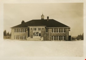
Second Street School
https://search.heritageburnaby.ca/link/museumdescription1263
- Repository
- Burnaby Village Museum
- Date
- January 1929
- Collection/Fonds
- Burnaby Village Museum Photograph collection
- Description Level
- Item
- Physical Description
- 1 photograph : sepia ; 5.5 x 8 cm
- Scope and Content
- Photograph of Second Street School taken from a distance.
- Repository
- Burnaby Village Museum
- Collection/Fonds
- Burnaby Village Museum Photograph collection
- Description Level
- Item
- Physical Description
- 1 photograph : sepia ; 5.5 x 8 cm
- Scope and Content
- Photograph of Second Street School taken from a distance.
- Subjects
- Buildings - Schools
- Names
- Second Street School
- Geographic Access
- 2nd Street
- Street Address
- 7502 2nd Street
- Accession Code
- BV997.21.20
- Access Restriction
- No restrictions
- Date
- January 1929
- Media Type
- Photograph
- Historic Neighbourhood
- East Burnaby (Historic Neighbourhood)
- Planning Study Area
- Second Street Area
- Scan Resolution
- 600
- Scan Date
- 01-Jun-09
- Scale
- 100
- Notes
- Title based on contents of photograph
- Note on verso of photograph: "SECOND ST. SCHOOL JAN. 1929 / Nina Chapman (Atkinson)"
Images
