Narrow Results By
Subject
- Advertising Medium - Signs and Signboards 1
- Buildings - Civic - Hospitals 5
- Buildings - Civic - Libraries 2
- Buildings - Civic - Museums 15
- Buildings - Commercial - Grocery Stores 1
- Buildings - Commercial - Hardware Stores 15
- Buildings - Heritage 40
- Buildings - Recreational - Community Halls 1
- Buildings - Recreational - Outdoor Swimming Pools 1
- Buildings - Recreational - Swimming Pools 1
- Buildings - Religious - Churches 1
- Buildings - Residential - Houses 13
Love farmhouse kitchen wall
https://search.heritageburnaby.ca/link/museumdescription1121
- Repository
- Burnaby Village Museum
- Date
- 1971 (date of original), copied 1990
- Collection/Fonds
- Love family fonds
- Description Level
- Item
- Physical Description
- 1 photograph : col. ; 10 x 15 cm print
- Scope and Content
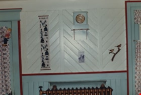
- Photograph of a wall in the Love farmhouse kitchen while Elsie (nee Love) Hughes, her husband John and son Brent lived in the house. The tongue and groove walls are painted white with teal blue borders and burgundy trim. A small clock sits on top of shelf on the wall. There is a narrow printed fabr…
- Repository
- Burnaby Village Museum
- Collection/Fonds
- Love family fonds
- Description Level
- Item
- Physical Description
- 1 photograph : col. ; 10 x 15 cm print
- Material Details
- Copy print was made from re-photographing an original colour slide
- Scope and Content
- Photograph of a wall in the Love farmhouse kitchen while Elsie (nee Love) Hughes, her husband John and son Brent lived in the house. The tongue and groove walls are painted white with teal blue borders and burgundy trim. A small clock sits on top of shelf on the wall. There is a narrow printed fabric banner hanging to the left and a relief of two birds sitting on a branch to the right. The original tongue and groove walls were built by George Love (Elsie's uncle). The house was located at 7651 Cumberland Street (Address pre 1960: 1390 Cumberland Road) and was moved from its original site to the Burnaby Village Museum in 1988 and designated a Municipal Heritage Landmark in 1992.
- Geographic Access
- Cumberland Street
- Street Address
- 7651 Cumberland Street
- Accession Code
- BV992.15.2
- Access Restriction
- Restricted access
- Reproduction Restriction
- May be restricted by third party rights
- Date
- 1971 (date of original), copied 1990
- Media Type
- Photograph
- Historic Neighbourhood
- East Burnaby (Historic Neighbourhood)
- Planning Study Area
- Cariboo-Armstrong Area
- Scan Resolution
- 600
- Scan Date
- 01-Jun-09
- Scale
- 100
- Photographer
- Parker, Albert "Bert"
- Notes
- Title based on contents of photograph
Images

Love farmhouse living room
https://search.heritageburnaby.ca/link/museumdescription1123
- Repository
- Burnaby Village Museum
- Date
- 1971 (date of original), copied 1990
- Collection/Fonds
- Love family fonds
- Description Level
- Item
- Physical Description
- 1 photograph : col. ; 10 x 15 cm print
- Scope and Content
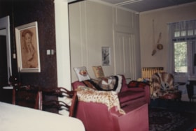
- Photograph of the interior of the Love farmhouse living room while Elsie (nee Love) Hughes, her husband John and son Brent lived in the house. This room was closed off and used as a bedroom by Jesse and Martha Love while they lived there. The house was located at 7651 Cumberland Street (Address pre…
- Repository
- Burnaby Village Museum
- Collection/Fonds
- Love family fonds
- Description Level
- Item
- Physical Description
- 1 photograph : col. ; 10 x 15 cm print
- Material Details
- Copy print was made from re-photographing an original colour slide
- Scope and Content
- Photograph of the interior of the Love farmhouse living room while Elsie (nee Love) Hughes, her husband John and son Brent lived in the house. This room was closed off and used as a bedroom by Jesse and Martha Love while they lived there. The house was located at 7651 Cumberland Street (Address pre 1960: 1390 Cumberland Road) and was moved from its original site to the Burnaby Village Museum in 1988 and designated a Municipal Heritage Landmark in 1992.
- Geographic Access
- Cumberland Street
- Street Address
- 7651 Cumberland Street
- Accession Code
- BV992.15.4
- Access Restriction
- Restricted access
- Reproduction Restriction
- May be restricted by third party rights
- Date
- 1971 (date of original), copied 1990
- Media Type
- Photograph
- Historic Neighbourhood
- East Burnaby (Historic Neighbourhood)
- Planning Study Area
- Cariboo-Armstrong Area
- Scan Resolution
- 600
- Scan Date
- 01-Jun-09
- Scale
- 100
- Photographer
- Parker, Albert "Bert"
- Notes
- Title based on contents of photograph
Images

![Love farmhouse on Cumberland Road, [197-] thumbnail](/media/hpo/_Data/_BVM_Images/2022/2022_0032_0305_001.jpg?width=280)
Love farmhouse on Cumberland Road
https://search.heritageburnaby.ca/link/museumdescription19883
- Repository
- Burnaby Village Museum
- Date
- [197-]
- Collection/Fonds
- Esther Love Stanley fonds
- Description Level
- Item
- Physical Description
- 1 photograph : col. ; 9 x 12.5 cm
- Scope and Content
- Photograph of the Jesse and Martha Love family farm house on Cumberland Street. Side view of house with trees and porch off of kitchen.
- Repository
- Burnaby Village Museum
- Collection/Fonds
- Esther Love Stanley fonds
- Description Level
- Item
- Physical Description
- 1 photograph : col. ; 9 x 12.5 cm
- Scope and Content
- Photograph of the Jesse and Martha Love family farm house on Cumberland Street. Side view of house with trees and porch off of kitchen.
- Subjects
- Buildings - Heritage
- Names
- Love Family
- Geographic Access
- Cumberland Street
- Street Address
- 7651 Cumberland Street
- Accession Code
- BV022.32.305
- Access Restriction
- No restrictions
- Reproduction Restriction
- No known restrictions
- Date
- [197-]
- Media Type
- Photograph
- Historic Neighbourhood
- East Burnaby (Historic Neighbourhood)
- Planning Study Area
- Cariboo-Armstrong Area
- Scan Resolution
- 600
- Scan Date
- 2023-05-09
- Notes
- Title based on contents of photograph
- Photograph is part of Esther Love Stanley photograph album 1 (BV022.32.1)
- Note on label adhered to photograph reads: "Old home at Cumberland Rd. / side view"
Images
![Love farmhouse on Cumberland Road, [197-] thumbnail](/media/hpo/_Data/_BVM_Images/2022/2022_0032_0305_001.jpg)
![Love house parlour, [between 1966 and 1970] thumbnail](/media/hpo/_Data/_BVM_Images/2019/2019_0003_0008_001.jpg?width=280)
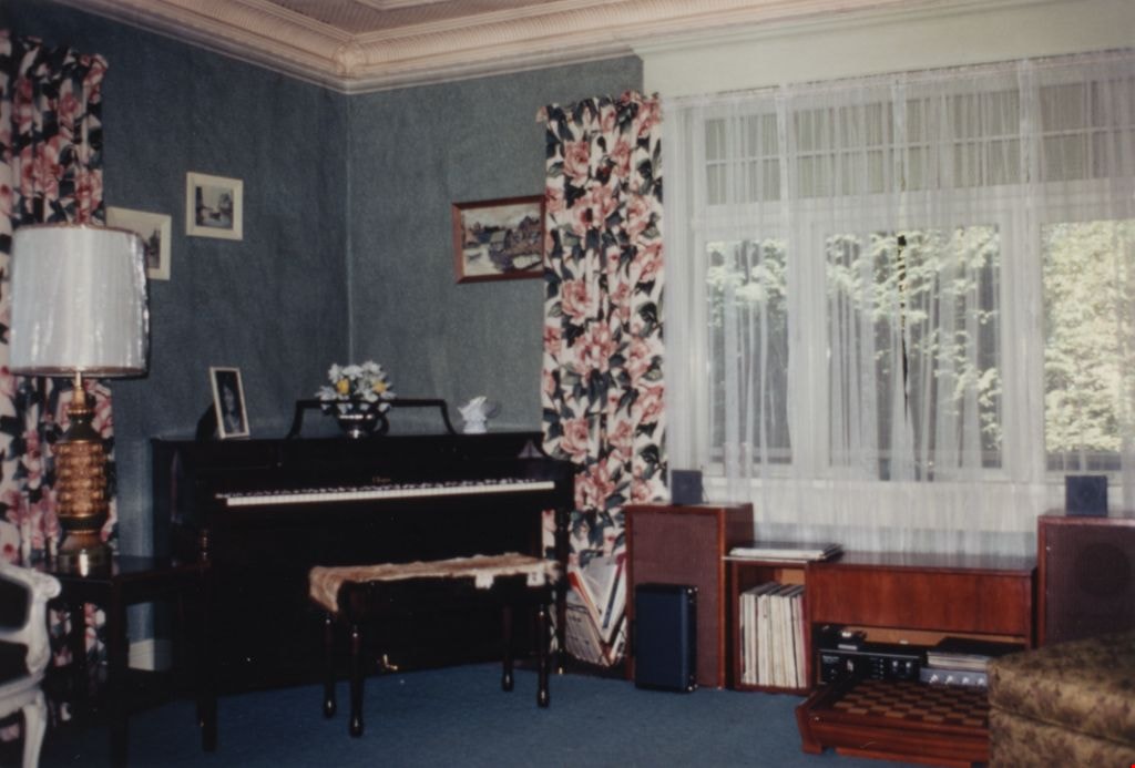
Love house parlour
https://search.heritageburnaby.ca/link/museumdescription9922
- Repository
- Burnaby Village Museum
- Date
- [between 1966 and 1970]
- Collection/Fonds
- Love family fonds
- Description Level
- Item
- Physical Description
- 1 photograph : col. ; 10 x 15 cm print
- Scope and Content
- Photograph of the interior of the Love farmhouse parlour with a large picture window, piano, floral drapery and two ornate chairs. The house was located at 7651 Cumberland Street (Address pre 1960: 1390 Cumberland Road). This photograph was taken while Elsie Hughes (nee Love), her husband John Hugh…
- Repository
- Burnaby Village Museum
- Collection/Fonds
- Love family fonds
- Description Level
- Item
- Physical Description
- 1 photograph : col. ; 10 x 15 cm print
- Material Details
- Copy print was made from re-photographing an original colour slide
- Scope and Content
- Photograph of the interior of the Love farmhouse parlour with a large picture window, piano, floral drapery and two ornate chairs. The house was located at 7651 Cumberland Street (Address pre 1960: 1390 Cumberland Road). This photograph was taken while Elsie Hughes (nee Love), her husband John Hughes and son Brent Hughes lived in the house. Elsie is the daughter of Sarah (nee Love) and William Parker. Sarah and William purchased the house in 1928, shortly after the death of Sarah's father, Jesse Love. Sarah and William Parker lived in the house with their three children, Albert, Bill and Elsie. William Parker died in 1961 and Sarah continued to live in the house until 1966 before selling it to her daughter Elsie and son in law John Hughes. Elsie and John lived in the house with their son Brent until 1971.
- Subjects
- Buildings - Heritage
- Geographic Access
- Cumberland Street
- Street Address
- 7651 Cumberland Street
- Accession Code
- BV019.3.8
- Access Restriction
- No restrictions
- Reproduction Restriction
- No known restrictions
- Date
- [between 1966 and 1970]
- Media Type
- Photograph
- Historic Neighbourhood
- East Burnaby (Historic Neighbourhood)
- Planning Study Area
- Cariboo-Armstrong Area
- Scan Resolution
- 600
- Scan Date
- 31-Jan-2019
- Scale
- 96
- Photographer
- Parker, Albert "Bert"
- Notes
- Title based on content of photograph
- See also BV992.15.5 and BV019.3.7; BV019.3.9
Images
![Love house parlour, [between 1966 and 1970] thumbnail](/media/hpo/_Data/_BVM_Images/2019/2019_0003_0008_001.jpg)
![Love house parlour, [between 1966 and 1970] thumbnail](/media/hpo/_Data/_BVM_Images/2019/2019_0003_0007_001.jpg?width=280)
Love house parlour
https://search.heritageburnaby.ca/link/museumdescription9923
- Repository
- Burnaby Village Museum
- Date
- [between 1966 and 1970]
- Collection/Fonds
- Love family fonds
- Description Level
- Item
- Physical Description
- 1 photograph : col. ; 10 x 15 cm print
- Scope and Content
- Photograph of the interior of the Love farmhouse parlour with a large picture window, piano, floral drapery and two ornate chairs. The house was located at 7651 Cumberland Street (Address pre 1960: 1390 Cumberland Road). This photograph was taken while Elsie Hughes (nee Love), her husband John Hugh…
- Repository
- Burnaby Village Museum
- Collection/Fonds
- Love family fonds
- Description Level
- Item
- Physical Description
- 1 photograph : col. ; 10 x 15 cm print
- Material Details
- Copy print was made from re-photographing an original colour slide
- Scope and Content
- Photograph of the interior of the Love farmhouse parlour with a large picture window, piano, floral drapery and two ornate chairs. The house was located at 7651 Cumberland Street (Address pre 1960: 1390 Cumberland Road). This photograph was taken while Elsie Hughes (nee Love), her husband John Hughes and son Brent Hughes lived in the house. Elsie is the daughter of Sarah (nee Love) and William Parker. Sarah and William purchased the house in 1928, shortly after the death of Sarah's father, Jesse Love. Sarah and William Parker lived in the house with their three children, Albert, Bill and Elsie. William Parker died in 1961 and Sarah continued to live in the house until 1966 before selling it to her daughter Elsie and son in law John Hughes. Elsie and John lived in the house with their son Brent until 1971.
- Subjects
- Buildings - Heritage
- Geographic Access
- Cumberland Street
- Street Address
- 7651 Cumberland Street
- Accession Code
- BV019.3.7
- Access Restriction
- No restrictions
- Reproduction Restriction
- No known restrictions
- Date
- [between 1966 and 1970]
- Media Type
- Photograph
- Historic Neighbourhood
- East Burnaby (Historic Neighbourhood)
- Planning Study Area
- Cariboo-Armstrong Area
- Scan Resolution
- 600
- Scan Date
- 31-Jan-2019
- Scale
- 96
- Photographer
- Parker, Albert "Bert"
- Notes
- Title based on contents of photograph
- See also BV992.15.5 and BV019.3.9; BV019.3.8
Images
![Love house parlour, [between 1966 and 1970] thumbnail](/media/hpo/_Data/_BVM_Images/2019/2019_0003_0007_001.jpg)
![Love house parlour, [between 1966 and 1970] thumbnail](/media/hpo/_Data/_BVM_Images/2019/2019_0003_0009_001.jpg?width=280)
Love house parlour
https://search.heritageburnaby.ca/link/museumdescription9924
- Repository
- Burnaby Village Museum
- Date
- [between 1966 and 1970]
- Collection/Fonds
- Love family fonds
- Description Level
- Item
- Physical Description
- 1 photograph : col. ; 10 x 15 cm print
- Scope and Content
- Photograph of the interior of the Love farmhouse parlour with a large picture window, piano, floral drapery and two ornate chairs. The house was located at 7651 Cumberland Street (Address pre 1960: 1390 Cumberland Road). This photograph was taken while Elsie Hughes (nee Love), her husband John Hugh…
- Repository
- Burnaby Village Museum
- Collection/Fonds
- Love family fonds
- Description Level
- Item
- Physical Description
- 1 photograph : col. ; 10 x 15 cm print
- Material Details
- Copy print was made from re-photographing an original colour slide
- Scope and Content
- Photograph of the interior of the Love farmhouse parlour with a large picture window, piano, floral drapery and two ornate chairs. The house was located at 7651 Cumberland Street (Address pre 1960: 1390 Cumberland Road). This photograph was taken while Elsie Hughes (nee Love), her husband John Hughes and son Brent Hughes lived in the house. Elsie is the daughter of Sarah (nee Love) and William Parker. Sarah and William purchased the house in 1928, shortly after the death of Sarah's father, Jesse Love. Sarah and William Parker lived in the house with their three children, Albert, Bill and Elsie. William Parker died in 1961 and Sarah continued to live in the house until 1966 before selling it to her daughter Elsie and son in law John Hughes. Elsie and John lived in the house with their son Brent until 1971.
- Subjects
- Buildings - Heritage
- Geographic Access
- Cumberland Street
- Street Address
- 7651 Cumberland Street
- Accession Code
- BV019.3.9
- Access Restriction
- No restrictions
- Reproduction Restriction
- No known restrictions
- Date
- [between 1966 and 1970]
- Media Type
- Photograph
- Historic Neighbourhood
- East Burnaby (Historic Neighbourhood)
- Planning Study Area
- Cariboo-Armstrong Area
- Scan Resolution
- 600
- Scan Date
- 31-Jan-2019
- Scale
- 96
- Photographer
- Parker, Albert "Bert"
- Notes
- Title based on contents of photograph
- See also BV992.15.5 and BV019.3.7; BV019.3.8
Images
![Love house parlour, [between 1966 and 1970] thumbnail](/media/hpo/_Data/_BVM_Images/2019/2019_0003_0009_001.jpg)
![Mike Loynes, [ca. 1972] (date of original), copied 1991 thumbnail](/media/hpo/_Data/_Archives_Images/_Unrestricted/370/370-259.jpg?width=280)
Mike Loynes
https://search.heritageburnaby.ca/link/archivedescription37671
- Repository
- City of Burnaby Archives
- Date
- [ca. 1972] (date of original), copied 1991
- Collection/Fonds
- Burnaby Historical Society fonds
- Description Level
- Item
- Physical Description
- 1 photograph : b&w ; 3.9 x 3.9 cm print on contact sheet 20.2 x 25.3 cm
- Scope and Content
- Photograph of Mike Loynes standing beside his car in front of 1855 18th Avenue (later renumbered as the 7000 block of 18th Avenue).
- Repository
- City of Burnaby Archives
- Date
- [ca. 1972] (date of original), copied 1991
- Collection/Fonds
- Burnaby Historical Society fonds
- Subseries
- Burnaby Image Bank subseries
- Physical Description
- 1 photograph : b&w ; 3.9 x 3.9 cm print on contact sheet 20.2 x 25.3 cm
- Description Level
- Item
- Record No.
- 370-259
- Access Restriction
- No restrictions
- Reproduction Restriction
- No restrictions
- Accession Number
- BHS1999-03
- Scope and Content
- Photograph of Mike Loynes standing beside his car in front of 1855 18th Avenue (later renumbered as the 7000 block of 18th Avenue).
- Names
- Loynes, Michael "Mike"
- Media Type
- Photograph
- Notes
- Title based on contents of photograph
- 1 b&w copy negative accompanying
- Copied from col. photograph
- Negative has a pink cast
- Geographic Access
- 18th Avenue
- Historic Neighbourhood
- East Burnaby (Historic Neighbourhood)
- Planning Study Area
- Stride Avenue Area
Images
![Mike Loynes, [ca. 1972] (date of original), copied 1991 thumbnail](/media/hpo/_Data/_Archives_Images/_Unrestricted/370/370-259.jpg)
Nickel Bros. house moving ltd.
https://search.heritageburnaby.ca/link/museumdescription16901
- Repository
- Burnaby Village Museum
- Date
- Aug. 1974
- Collection/Fonds
- Burnaby Village Museum fonds
- Description Level
- Item
- Physical Description
- 1 photograph : col. slide ; 35 mm
- Scope and Content
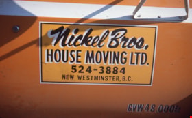
- Photograph of a sign on the door of the Nickel Brothers house moving company truck. The truck is bright yellow and the sign reads "Nickel Bros./ House Moving Ltd. 524-3884 / New Westminster B.C." The Nickel Brothers moved the Whitechurch Hardware building from 7685 Sixth Street to Heritage Village …
- Repository
- Burnaby Village Museum
- Collection/Fonds
- Burnaby Village Museum fonds
- Subseries
- Bell's building photographs subseries
- Description Level
- Item
- Physical Description
- 1 photograph : col. slide ; 35 mm
- Scope and Content
- Photograph of a sign on the door of the Nickel Brothers house moving company truck. The truck is bright yellow and the sign reads "Nickel Bros./ House Moving Ltd. 524-3884 / New Westminster B.C." The Nickel Brothers moved the Whitechurch Hardware building from 7685 Sixth Street to Heritage Village (Burnaby Village Museum).
- Geographic Access
- 6th Street
- Street Address
- 7685 6th Street
- Accession Code
- BV020.5.1871
- Access Restriction
- No restrictions
- Reproduction Restriction
- No known restrictions
- Date
- Aug. 1974
- Media Type
- Photograph
- Historic Neighbourhood
- East Burnaby (Historic Neighbourhood)
- Planning Study Area
- Second Street Area
- Scan Resolution
- 2400
- Scale
- 100
- Notes
- Title based on contents of photograph
- Note in blue ink on slide frame reads: Nickel Bros. / did moving of / Whitechurch"
Images


Nickel Bros. truck on street
https://search.heritageburnaby.ca/link/museumdescription16902
- Repository
- Burnaby Village Museum
- Date
- Aug. 1974
- Collection/Fonds
- Burnaby Village Museum fonds
- Description Level
- Item
- Physical Description
- 1 photograph : col. slide ; 35 mm
- Scope and Content
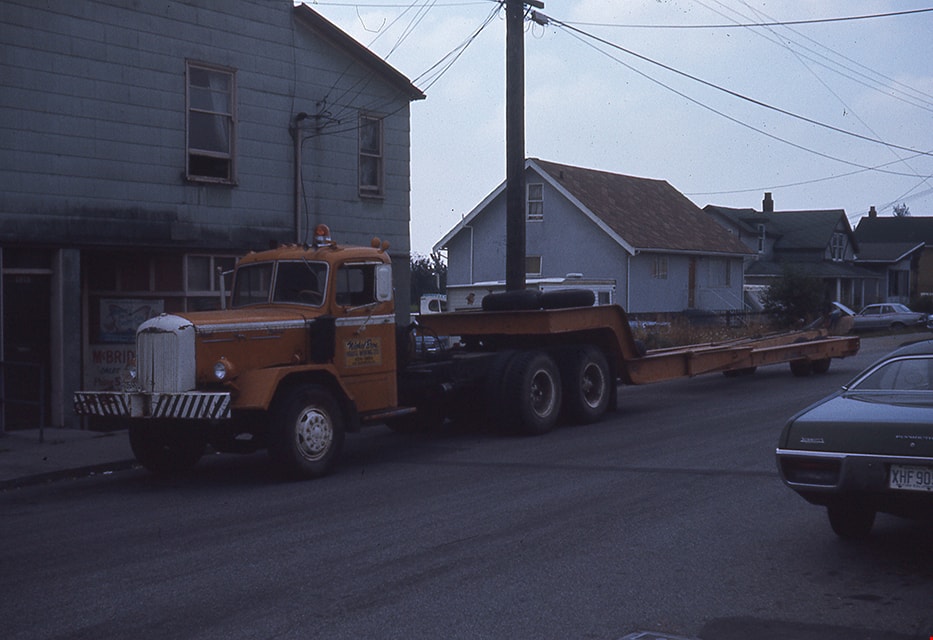
- Photograph of the Nickel Brothers house moving company truck parked on a street (could be near the corner of Sixth Street and Thirteenth Avenue). The Nickel Brothers moved the Whitechurch Hardware building from 7685 Sixth Street to Heritage Village (Burnaby Village Museum).
- Repository
- Burnaby Village Museum
- Collection/Fonds
- Burnaby Village Museum fonds
- Subseries
- Bell's building photographs subseries
- Description Level
- Item
- Physical Description
- 1 photograph : col. slide ; 35 mm
- Scope and Content
- Photograph of the Nickel Brothers house moving company truck parked on a street (could be near the corner of Sixth Street and Thirteenth Avenue). The Nickel Brothers moved the Whitechurch Hardware building from 7685 Sixth Street to Heritage Village (Burnaby Village Museum).
- Geographic Access
- 6th Street
- Street Address
- 7685 6th Street
- Accession Code
- BV020.5.1872
- Access Restriction
- No restrictions
- Reproduction Restriction
- No known restrictions
- Date
- Aug. 1974
- Media Type
- Photograph
- Historic Neighbourhood
- East Burnaby (Historic Neighbourhood)
- Planning Study Area
- Second Street Area
- Scan Resolution
- 2400
- Scale
- 100
- Notes
- Title based on contents of photograph
- Note in blue ink on slide frame reads: "Truck that hauled / Whitechurch"
Images

Nordic Centre
https://search.heritageburnaby.ca/link/archivedescription79734
- Repository
- City of Burnaby Archives
- Date
- November 1, 1976
- Collection/Fonds
- Burnaby Public Library Contemporary Visual Archive Project
- Description Level
- Item
- Physical Description
- 1 photograph : b&w ; 11 x 16 cm mounted on cardboard
- Scope and Content
- Photograph shows the Nordic Centre, located on 6th Street on the corner of 12th Avenue. A billboard advertising its services is attached to the side of the building. A few months after this photo was taken, the Nordic Centre was torn down.
- Repository
- City of Burnaby Archives
- Date
- November 1, 1976
- Collection/Fonds
- Burnaby Public Library Contemporary Visual Archive Project
- Physical Description
- 1 photograph : b&w ; 11 x 16 cm mounted on cardboard
- Description Level
- Item
- Record No.
- 556-407
- Access Restriction
- No restrictions
- Reproduction Restriction
- Reproduce for fair dealing purposes only
- Accession Number
- 2013-13
- Scope and Content
- Photograph shows the Nordic Centre, located on 6th Street on the corner of 12th Avenue. A billboard advertising its services is attached to the side of the building. A few months after this photo was taken, the Nordic Centre was torn down.
- Names
- Nordic Centre
- Media Type
- Photograph
- Notes
- Scope note taken directly from BPL photograph description.
- 1 b&w copy negative : 10 x 12.5 cm accompanying
- Photographers identified by surnames only: Carr and Vardeman
- Geographic Access
- 6th Street
- 12th Avenue
- Historic Neighbourhood
- East Burnaby (Historic Neighbourhood)
- Planning Study Area
- Second Street Area
Images

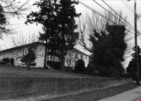
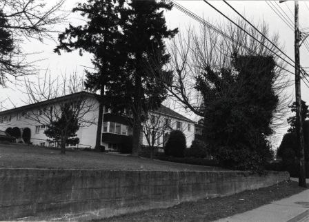
Normanna Rest Home
https://search.heritageburnaby.ca/link/archivedescription79510
- Repository
- City of Burnaby Archives
- Date
- February 7, 1977
- Collection/Fonds
- Burnaby Public Library Contemporary Visual Archive Project
- Description Level
- Item
- Physical Description
- 1 photograph : b&w ; 11 x 16 cm mounted on cardboard
- Scope and Content
- Photograph shows the Normanna Rest Home at 7979 12th Avenue (later 7725 4th Street).
- Repository
- City of Burnaby Archives
- Date
- February 7, 1977
- Collection/Fonds
- Burnaby Public Library Contemporary Visual Archive Project
- Physical Description
- 1 photograph : b&w ; 11 x 16 cm mounted on cardboard
- Description Level
- Item
- Record No.
- 556-337
- Access Restriction
- No restrictions
- Reproduction Restriction
- Reproduce for fair dealing purposes only
- Accession Number
- 2013-13
- Scope and Content
- Photograph shows the Normanna Rest Home at 7979 12th Avenue (later 7725 4th Street).
- Names
- Normanna Rest Home
- Media Type
- Photograph
- Notes
- Scope note taken directly from BPL photograph description.
- 1 b&w copy negative : 10 x 12.5 cm accompanying
- Photographers identified by surnames only: Carr and Vardeman
- Geographic Access
- 4th Street
- Street Address
- 7725 4th Street
- Historic Neighbourhood
- East Burnaby (Historic Neighbourhood)
- Planning Study Area
- Second Street Area
Images
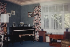
Parlour / Music room in Love farmhouse
https://search.heritageburnaby.ca/link/museumdescription1124
- Repository
- Burnaby Village Museum
- Date
- 1971 (date of original), copied 1990
- Collection/Fonds
- Love family fonds
- Description Level
- Item
- Physical Description
- 1 photograph : col. ; 10 x 15 cm print
- Scope and Content
- Photograph of the interior of the Love farmhouse parlour / music room while Elsie (nee Love) Hughes, her husband John and son Brent lived in the house. There is a piano and stereo against the outside interior walls and a large picture window. The house was located at 7651 Cumberland Street (Address…
- Repository
- Burnaby Village Museum
- Collection/Fonds
- Love family fonds
- Description Level
- Item
- Physical Description
- 1 photograph : col. ; 10 x 15 cm print
- Material Details
- Copy print was made from re-photographing an original colour slide
- Scope and Content
- Photograph of the interior of the Love farmhouse parlour / music room while Elsie (nee Love) Hughes, her husband John and son Brent lived in the house. There is a piano and stereo against the outside interior walls and a large picture window. The house was located at 7651 Cumberland Street (Address pre 1960: 1390 Cumberland Road) and was moved from its original site to the Burnaby Village Museum in 1988 and designated a Municipal Heritage Landmark in 1992.
- Geographic Access
- Cumberland Street
- Street Address
- 7651 Cumberland Street
- Accession Code
- BV992.15.5
- Access Restriction
- Restricted access
- Reproduction Restriction
- May be restricted by third party rights
- Date
- 1971 (date of original), copied 1990
- Media Type
- Photograph
- Historic Neighbourhood
- East Burnaby (Historic Neighbourhood)
- Planning Study Area
- Cariboo-Armstrong Area
- Scan Resolution
- 600
- Scan Date
- 01-Jun-09
- Scale
- 100
- Photographer
- Parker, Albert "Bert"
- Notes
- Title based on contents of photograph
Images
Pioneer Days interviews September 22, 1971 - Track 1
https://search.heritageburnaby.ca/link/oralhistory266
- Repository
- City of Burnaby Archives
- Date Range
- 1891-1955
- Length
- 0:05:35
- Summary
- This portion of the recording includes Lillian May (Davies) Jones's memories of her family life during the early days of Burnaby, mentioning her family home as well as the home of Reeve Shaw. Lillian is being interviewed in front of an audience at Heritage Village (now Burnaby Village Museum).
- Repository
- City of Burnaby Archives
- Summary
- This portion of the recording includes Lillian May (Davies) Jones's memories of her family life during the early days of Burnaby, mentioning her family home as well as the home of Reeve Shaw. Lillian is being interviewed in front of an audience at Heritage Village (now Burnaby Village Museum).
- Date Range
- 1891-1955
- Length
- 0:05:35
- Historic Neighbourhood
- East Burnaby (Historic Neighbourhood)
- Planning Study Area
- Second Street Area
- Interview Date
- September 22, 1971
- Scope and Content
- Recording is of interviews with Lillian May (Davies) Jones, Ada Evelyn (Lewis) Groves, Lillian Frederica (Lewis) Porter, and Elsie Wilson during the Pioneer Days celebration at Heritage Village (now Burnaby Village Museum) on September 22, 1971. Major themes discussed are: personal memories and occupations of interviewees family members.
- Biographical Notes
- Lillian May Davies was born June 28, 1891 to George and Rachel (Mills) Davies. She was one of four children. George Davies married Rachel Mills September 12, 1888 in Winnipeg and headed west to make their home. George’s brother Richard Davies had already bought property at the corner of 16th Street and 3rd Avenue (now 12th Avenue) when Rachel and George moved in and built a house next door. George Davies went to work for Gilley Bros. Logging Co. in Burnaby. Lillian May Davies married John Henry Jones on July 29, 1909 at the Methodist Church in Burnaby which had opened only a few weeks before (the Joneses were the first couple to be married there). Their reception was held in the Davies’ family garden. On June 3, 1910, Lillian and John’s first child, Arnold Jones was born. In 1919 they adopted their second child, John Sheldon Jones whose birth parents had died of influenza. John and Lillian built a home on the lot next to Lillian’s parents and lived there for forty-eight years. After her husband’s death in 1956, Lillian moved one lot over and remained living there for over twenty years. Lillian May (Davies) Jones died in Surrey on June 24, 1981 at the age of eighty-nine for over twenty years. Lillian May (Davies) Jones died in Surrey on June 24, 1981 at the age of eighty-nine. Ada Evelyn Lewis was born on September 11, 1899. She was one of nine Lewis children. Ada's father came to Victoria BC from San Francisco. He met his wife in Victoria and moved to New Westminster where he was a typesetter on the first edition of the Columbian newspaper. He continued to work for the Columbian until his retirement. Her family owned the East Burnaby Fruit Farm at 17th Avenue between 2nd and 4th Street where they harvested apples, plums and pears. Ada attended East Burnaby School in 1905 and remembers being a pupil of Miss Draper. Ada E. Lewis married and became Mrs. Ada Evelyn Groves. Lillian Frederica “Lillie” Lewis was born in 1896 to William Henry and Emma (Smith) Lewis at the family farm at 4th Street and 18th Avenue. The family grew to nine, eldest to youngest; Albert, Lizzie, Minnie, Walter, Ernest, Lillie and Evelyn. Lillie’s mother, Emma (Smith) had the distinction of being the first girl of European descent to be born at Fort Victoria. Lillie’s father, William Henry Lewis helped to print the very first edition of the Vancouver Province in 1898. Lillie attended Douglas Road School and remembers being a pupil of Ellen Lister. Lillian Frederica “Lillie” Lewis married Bertie Blaine Porter at Lulu Island on November 7, 1918. They lived in Vancouver for a short time before returning to Burnaby to raise their four children. For most of his working life Bert operated a steam roller for the municipality. Lillian Frederica (Lewis) Porter died May 18, 1988 at the age of ninety-two. Elsie Wilson was born August 16, 1898 to Annie and her second husband William Wilson. Annie’s first husband Samuel W Walmsley died December 20, 1895 at the age of thirty-five, leaving Annie a widow at twenty-seven with two young children Annie age four and Samuel age six. Annie Walmsley married her second husband William Wilson on April 17, 1897. Elsie attended West Burnaby public school (later Kingsway West elementary) and remembers picking raspberries at various Burnaby farms for seven seasons.
- Total Tracks
- 4
- Total Length
- 0:24:19
- Interviewee Name
- Jones, Lillian May Davies
- Wilson, Elsie
- Porter, Lillie Lewis
- Groves, Ada Evelyn Lewis
- Interview Location
- Burnaby Village Museum, Burnaby
- Collection/Fonds
- Burnaby Historical Society fonds
- Subseries
- Oral history subseries
- Transcript Available
- None
- Media Type
- Sound Recording
- Web Notes
- Interview was digitized in 2010 allowing it to be accessible on Heritage Burnaby. The digitization project was initiated by the Community Heritage Commission with support from City of Burnaby Council and the BC History Digitization Program of the Irving K. Barber Learning Centre, University of British Columbia. It was recognized by the Heritage Society of BC with an award in 2012.
Audio Tracks
Track one of recording of Pioneer Days interviews
Track one of recording of Pioneer Days interviews
https://search.heritageburnaby.ca/media/hpo/_Data/_Archives_Oral_Histories/_Unrestricted/MSS137-020/MSS137-020_Track_1.mp3Pioneer Days interviews September 22, 1971 - Track 2
https://search.heritageburnaby.ca/link/oralhistory267
- Repository
- City of Burnaby Archives
- Date Range
- 1899-1905
- Length
- 0:06:43
- Summary
- This portion of the recording includes Ada Evelyn (Lewis) Groves memories of her family life during the early days of Burnaby. She mentions the East Burnaby Fruit Farm (her family's farm) and the George Leaf General Store. She also talks about her brothers and her father, the first typesetter for t…
- Repository
- City of Burnaby Archives
- Summary
- This portion of the recording includes Ada Evelyn (Lewis) Groves memories of her family life during the early days of Burnaby. She mentions the East Burnaby Fruit Farm (her family's farm) and the George Leaf General Store. She also talks about her brothers and her father, the first typesetter for the Columbian newspaper. Ada is being interviewed in front of an audience at Heritage Village (now Burnaby Village Museum).
- Date Range
- 1899-1905
- Length
- 0:06:43
- Geographic Access
- 12th Avenue
- Historic Neighbourhood
- East Burnaby (Historic Neighbourhood)
- Planning Study Area
- Edmonds Area
- Interview Date
- September 22, 1971
- Scope and Content
- Recording is of interviews with Lillian May (Davies) Jones, Ada Evelyn (Lewis) Groves, Lillian Frederica (Lewis) Porter, and Elsie Wilson during the Pioneer Days celebration at Heritage Village (now Burnaby Village Museum) on September 22, 1971. Major themes discussed are: personal memories and occupations of interviewees family members.
- Biographical Notes
- Lillian May Davies was born June 28, 1891 to George and Rachel (Mills) Davies. She was one of four children. George Davies married Rachel Mills September 12, 1888 in Winnipeg and headed west to make their home. George’s brother Richard Davies had already bought property at the corner of 16th Street and 3rd Avenue (now 12th Avenue) when Rachel and George moved in and built a house next door. George Davies went to work for Gilley Bros. Logging Co. in Burnaby. Lillian May Davies married John Henry Jones on July 29, 1909 at the Methodist Church in Burnaby which had opened only a few weeks before (the Joneses were the first couple to be married there). Their reception was held in the Davies’ family garden. On June 3, 1910, Lillian and John’s first child, Arnold Jones was born. In 1919 they adopted their second child, John Sheldon Jones whose birth parents had died of influenza. John and Lillian built a home on the lot next to Lillian’s parents and lived there for forty-eight years. After her husband’s death in 1956, Lillian moved one lot over and remained living there for over twenty years. Lillian May (Davies) Jones died in Surrey on June 24, 1981 at the age of eighty-nine for over twenty years. Lillian May (Davies) Jones died in Surrey on June 24, 1981 at the age of eighty-nine. Ada Evelyn Lewis was born on September 11, 1899. She was one of nine Lewis children. Ada's father came to Victoria BC from San Francisco. He met his wife in Victoria and moved to New Westminster where he was a typesetter on the first edition of the Columbian newspaper. He continued to work for the Columbian until his retirement. Her family owned the East Burnaby Fruit Farm at 17th Avenue between 2nd and 4th Street where they harvested apples, plums and pears. Ada attended East Burnaby School in 1905 and remembers being a pupil of Miss Draper. Ada E. Lewis married and became Mrs. Ada Evelyn Groves. Lillian Frederica “Lillie” Lewis was born in 1896 to William Henry and Emma (Smith) Lewis at the family farm at 4th Street and 18th Avenue. The family grew to nine, eldest to youngest; Albert, Lizzie, Minnie, Walter, Ernest, Lillie and Evelyn. Lillie’s mother, Emma (Smith) had the distinction of being the first girl of European descent to be born at Fort Victoria. Lillie’s father, William Henry Lewis helped to print the very first edition of the Vancouver Province in 1898. Lillie attended Douglas Road School and remembers being a pupil of Ellen Lister. Lillian Frederica “Lillie” Lewis married Bertie Blaine Porter at Lulu Island on November 7, 1918. They lived in Vancouver for a short time before returning to Burnaby to raise their four children. For most of his working life Bert operated a steam roller for the municipality. Lillian Frederica (Lewis) Porter died May 18, 1988 at the age of ninety-two. Elsie Wilson was born August 16, 1898 to Annie and her second husband William Wilson. Annie’s first husband Samuel W Walmsley died December 20, 1895 at the age of thirty-five, leaving Annie a widow at twenty-seven with two young children Annie age four and Samuel age six. Annie Walmsley married her second husband William Wilson on April 17, 1897. Elsie attended West Burnaby public school (later Kingsway West elementary) and remembers picking raspberries at various Burnaby farms for seven seasons.
- Total Tracks
- 4
- Total Length
- 0:24:19
- Interviewee Name
- Jones, Lillian May Davies
- Wilson, Elsie
- Porter, Lillie Lewis
- Groves, Ada Evelyn Lewis
- Interview Location
- Burnaby Village Museum, Burnaby
- Collection/Fonds
- Burnaby Historical Society fonds
- Subseries
- Oral history subseries
- Transcript Available
- None
- Media Type
- Sound Recording
- Web Notes
- Interview was digitized in 2010 allowing it to be accessible on Heritage Burnaby. The digitization project was initiated by the Community Heritage Commission with support from City of Burnaby Council and the BC History Digitization Program of the Irving K. Barber Learning Centre, University of British Columbia. It was recognized by the Heritage Society of BC with an award in 2012.
Audio Tracks
Track two of recording of Pioneer Days interviews
Track two of recording of Pioneer Days interviews
https://search.heritageburnaby.ca/media/hpo/_Data/_Archives_Oral_Histories/_Unrestricted/MSS137-020/MSS137-020_Track_2.mp3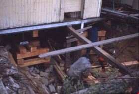
Placing timbers under Whitechurch Hardware
https://search.heritageburnaby.ca/link/museumdescription16887
- Repository
- Burnaby Village Museum
- Date
- Aug. 1974
- Collection/Fonds
- Burnaby Village Museum fonds
- Description Level
- Item
- Physical Description
- 1 photograph : col. slide ; 35 mm
- Scope and Content
- Photograph of two people placing timbers and supports under the Whitechurch Hardware building in preparation to be moved by the Nickel Brothers house moving company from 7685 Sixth Street to Heritage Village (Burnaby Village Museum).
- Repository
- Burnaby Village Museum
- Collection/Fonds
- Burnaby Village Museum fonds
- Subseries
- Bell's building photographs subseries
- Description Level
- Item
- Physical Description
- 1 photograph : col. slide ; 35 mm
- Scope and Content
- Photograph of two people placing timbers and supports under the Whitechurch Hardware building in preparation to be moved by the Nickel Brothers house moving company from 7685 Sixth Street to Heritage Village (Burnaby Village Museum).
- Geographic Access
- 6th Street
- Street Address
- 7695 6th Street
- 7685 6th Street
- Accession Code
- BV020.5.1857
- Access Restriction
- No restrictions
- Reproduction Restriction
- No known restrictions
- Date
- Aug. 1974
- Media Type
- Photograph
- Historic Neighbourhood
- East Burnaby (Historic Neighbourhood)
- Planning Study Area
- Second Street Area
- Scan Resolution
- 2400
- Scale
- 100
- Notes
- Title based on contents of photograph
- Note in blue ink on slide frame reads: "(FRONT) / VIEW FROM THIS SIDE / WRONG SIDE / Whitechurch Hardware / Puttin in timbers"
- 1 col. copy print accompanying
Images

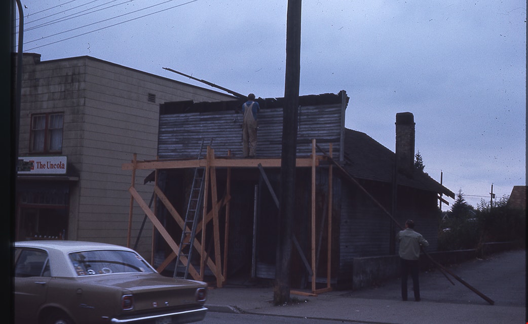
Removal of false front from Whitechurch Hardware
https://search.heritageburnaby.ca/link/museumdescription16898
- Repository
- Burnaby Village Museum
- Date
- Aug. 1974
- Collection/Fonds
- Burnaby Village Museum fonds
- Description Level
- Item
- Physical Description
- 1 photograph : col. slide ; 35 mm
- Scope and Content
- Photograph of Angelo Otten and an unidentified man removing the false front from the Whitechurch Hardware building located at 7685 Sixth Street. Angelo Otten is standing on wooden scaffolding in front of the store. A two storey building with convenience store at ground level is visible to the left …
- Repository
- Burnaby Village Museum
- Collection/Fonds
- Burnaby Village Museum fonds
- Subseries
- Bell's building photographs subseries
- Description Level
- Item
- Physical Description
- 1 photograph : col. slide ; 35 mm
- Scope and Content
- Photograph of Angelo Otten and an unidentified man removing the false front from the Whitechurch Hardware building located at 7685 Sixth Street. Angelo Otten is standing on wooden scaffolding in front of the store. A two storey building with convenience store at ground level is visible to the left (7695 Sixth Street).
- Geographic Access
- 6th Street
- Street Address
- 7695 6th Street
- 7685 6th Street
- Accession Code
- BV020.5.1868
- Access Restriction
- No restrictions
- Reproduction Restriction
- No known restrictions
- Date
- Aug. 1974
- Media Type
- Photograph
- Historic Neighbourhood
- East Burnaby (Historic Neighbourhood)
- Planning Study Area
- Second Street Area
- Scan Resolution
- 2400
- Scale
- 100
- Notes
- Title based on contents of photograph
- Note in blue ink on slide frame reads: "Angelo + co. taking / off false front / Whitechurch Aug / 74"
Images
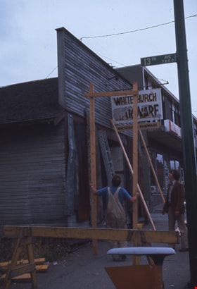
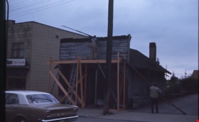
Removing false front from Whitechurch Hardware building
https://search.heritageburnaby.ca/link/museumdescription16892
- Repository
- Burnaby Village Museum
- Date
- Aug. 1974
- Collection/Fonds
- Burnaby Village Museum fonds
- Description Level
- Item
- Physical Description
- 1 photograph : col. slide ; 35 mm
- Scope and Content
- Photograph of Angelo Otten and Peter Otten removing the false front from the Whitechurch Hardware building during preparation for the building to be moved from it's location at 7685 Sixth Street to Heritage Village (Burnaby Village Museum). The Whitechurch Hardware sign is hanging from the from the…
- Repository
- Burnaby Village Museum
- Collection/Fonds
- Burnaby Village Museum fonds
- Subseries
- Bell's building photographs subseries
- Description Level
- Item
- Physical Description
- 1 photograph : col. slide ; 35 mm
- Scope and Content
- Photograph of Angelo Otten and Peter Otten removing the false front from the Whitechurch Hardware building during preparation for the building to be moved from it's location at 7685 Sixth Street to Heritage Village (Burnaby Village Museum). The Whitechurch Hardware sign is hanging from the from the false front. Street sign reading "13th Ave / 7800" is attached to a pole and visible in the foreground.
- Geographic Access
- 6th Street
- Street Address
- 7695 6th Street
- 7685 6th Street
- Accession Code
- BV020.5.1862
- Access Restriction
- No restrictions
- Reproduction Restriction
- No known restrictions
- Date
- Aug. 1974
- Media Type
- Photograph
- Historic Neighbourhood
- East Burnaby (Historic Neighbourhood)
- Planning Study Area
- Second Street Area
- Scan Resolution
- 2400
- Scale
- 100
- Notes
- Title based on contents of photograph
- Note in blue ink on slide frame reads: "FRONT / Removing false / front of White- / church / Aug 74 / Angelo & Peter / Otten"
Images

![Second Street School, [January 1978] thumbnail](/media/hpo/_Data/_Archives_Images/_Unrestricted/550/556-621.jpg?width=280)
Second Street School
https://search.heritageburnaby.ca/link/archivedescription93664
- Repository
- City of Burnaby Archives
- Date
- [January 1978]
- Collection/Fonds
- Burnaby Public Library Contemporary Visual Archive Project
- Description Level
- Item
- Physical Description
- 1 photograph : b&w ; 12.5 x 17.5 cm
- Scope and Content
- Photograph of the schoolyard and exterior of Second Street School. The photograph is taken from across the field, facing east. The photograph shows children playing in the field and the old school building, built in 1928, and the newer additions to the school. The mountains are visible in the backg…
- Repository
- City of Burnaby Archives
- Date
- [January 1978]
- Collection/Fonds
- Burnaby Public Library Contemporary Visual Archive Project
- Physical Description
- 1 photograph : b&w ; 12.5 x 17.5 cm
- Description Level
- Item
- Record No.
- 556-621
- Access Restriction
- No restrictions
- Reproduction Restriction
- Reproduce for fair dealing purposes only
- Accession Number
- 2017-57
- Scope and Content
- Photograph of the schoolyard and exterior of Second Street School. The photograph is taken from across the field, facing east. The photograph shows children playing in the field and the old school building, built in 1928, and the newer additions to the school. The mountains are visible in the background.
- Subjects
- Buildings - Schools
- Names
- Second Street School
- Media Type
- Photograph
- Photographer
- Surridge, Jack
- Notes
- Title taken from project information form
- Accompanied by a project information form and 1 photograph (b&w negative ; 9.5 x 12.5 cm)
- BPL no. 70
- Geographic Access
- 2nd Street
- Street Address
- 7502 2nd Street
- Historic Neighbourhood
- East Burnaby (Historic Neighbourhood)
- Planning Study Area
- Second Street Area
Images
![Second Street School, [January 1978] thumbnail](/media/hpo/_Data/_Archives_Images/_Unrestricted/550/556-621.jpg)
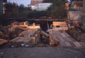
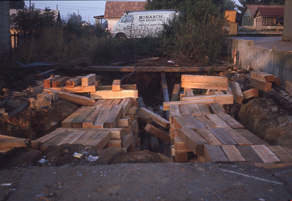
Site of former Whitechurch Hardware building
https://search.heritageburnaby.ca/link/museumdescription16903
- Repository
- Burnaby Village Museum
- Date
- Aug. 1974
- Collection/Fonds
- Burnaby Village Museum fonds
- Description Level
- Item
- Physical Description
- 1 photograph : col. slide ; 35 mm
- Scope and Content
- Photograph of timbers on the ground after the Whitechurch Hardware building was moved by Nickel Brothers house moving company from 7685 Sixth Street to Heritage Village (Burnaby Village Museum.
- Repository
- Burnaby Village Museum
- Collection/Fonds
- Burnaby Village Museum fonds
- Subseries
- Bell's building photographs subseries
- Description Level
- Item
- Physical Description
- 1 photograph : col. slide ; 35 mm
- Scope and Content
- Photograph of timbers on the ground after the Whitechurch Hardware building was moved by Nickel Brothers house moving company from 7685 Sixth Street to Heritage Village (Burnaby Village Museum.
- Geographic Access
- 6th Street
- Street Address
- 7685 6th Street
- Accession Code
- BV020.5.1873
- Access Restriction
- No restrictions
- Reproduction Restriction
- No known restrictions
- Date
- Aug. 1974
- Media Type
- Photograph
- Historic Neighbourhood
- East Burnaby (Historic Neighbourhood)
- Planning Study Area
- Second Street Area
- Scan Resolution
- 2400
- Scale
- 100
- Notes
- Title based on contents of photograph
- Note in blue ink on slide frame reads: "Timbers after / Whitechurch / removed from site"
Images
![Subdivision plans in New Westminster District Group 1 – Burnaby
, [1890-1910] thumbnail](/media/hpo/_Data/_BVM_Cartographic_Material/1977/1977_0093_0014a_001.jpg?width=280)
Subdivision plans in New Westminster District Group 1 – Burnaby
https://search.heritageburnaby.ca/link/museumdescription6983
- Repository
- Burnaby Village Museum
- Date
- [1890-1910]
- Collection/Fonds
- Burnaby Village Museum Map collection
- Description Level
- File
- Physical Description
- 4 plans : blueprint ink on paper mounted on 2 sides of cardboard 76 x 102 cm
- Scope and Content
- Item consists of a large board of two New Westminster District Gp 1 - subdivision plans mounted on one side and two New Westminster District Gp 1 - subdivision plans mounted on the other side. Side A: 1. Blueprint "Plan of / Subdivision of Lot No. 69 / Group One / New Westminster District / Pro…
- Repository
- Burnaby Village Museum
- Collection/Fonds
- Burnaby Village Museum Map collection
- Description Level
- File
- Physical Description
- 4 plans : blueprint ink on paper mounted on 2 sides of cardboard 76 x 102 cm
- Material Details
- Scales [between 1:1584 and 1:3168]
- Index number on edge of board reads: "14"
- Scope and Content
- Item consists of a large board of two New Westminster District Gp 1 - subdivision plans mounted on one side and two New Westminster District Gp 1 - subdivision plans mounted on the other side. Side A: 1. Blueprint "Plan of / Subdivision of Lot No. 69 / Group One / New Westminster District / Property of Ernest Buse, Esq. / Scale 3 chs = 1 in. / Map No 290". Plan is signed by "Garden, Hermon and Burwell, Dom. Land Surveyor" (Geographic location: Burnaby) 2. Blueprint "Plan / of Subdivision / of Lots 1-19, 36-53 and 69-75 inclusive / in the Subdivision / of / Lot 30 / Group One / New Westminster District / Scale 2 chs = 1 in. Map No 631". Plan is signed by "Jno [sic] Strathern [sic] P.L.S." Names and Lot numbers are handwritten in red pencil in sections along Douglas Road and read: "20 - F / 21 - Fitherstruhaul [sic] / 22 - J.S. Craig / 23 - McGill & Dill / 24 / 25 / 26 / 27 / 28 - School / 29 - School / 30 - D. McDownall / 31 - W.J. Troloow [sic] / 32 - N.C. Nelson / 33 - _[sic] McGill / 34 - T.S.[sic] Craig / 35" (Geographic location: Burnaby) Side B: 1.Blueprint "Plan / of Subdivision / of Centre Portion / of Lot 28 / Group One / New Westminster District / Scale 200' = 1" / Map No 627". Plan is signed by "Jno Strathern / P.L.S." (Geographic location: Burnaby) 2. Blueprint "Plan / of Subdivision / of N.1/2 Lot 100 and S.1/2 Lot 101, / Group One / New Westminster District, BC / Scale 4 chs = 1 in." (Geographic location: Burnaby)
- Names
- Strathern, John
- Accession Code
- HV977.93.14
- Access Restriction
- No restrictions
- Reproduction Restriction
- No known restrictions
- Date
- [1890-1910]
- Media Type
- Cartographic Material
- Historic Neighbourhood
- Broadview (Historic Neighbourhood)
- East Burnaby (Historic Neighbourhood)
- Planning Study Area
- Cascade-Schou Area
- West Central Valley Area
- Second Street Area
- Lake City Area
- Scan Resolution
- 300
- Scale
- 72
- Notes
- Title based on contents of file
- Scale is measured in chains and feet. (One chain equals 792 inches)
- The term "Lot" can also refer to a "District Lot”
Images
![Subdivision plans in New Westminster District Group 1 – Burnaby
, [1890-1910] thumbnail](/media/hpo/_Data/_BVM_Cartographic_Material/1977/1977_0093_0014a_001.jpg)
