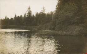
Deer Lake, Burnaby BC
https://search.heritageburnaby.ca/link/archivedescription38513
- Repository
- City of Burnaby Archives
- Date
- 1908
- Collection/Fonds
- Burnaby Historical Society fonds
- Description Level
- Item
- Physical Description
- 1 photograph : b&w postcard ; 9 x 14 cm
- Scope and Content
- Photographic postcard of Deer Lake. Stamped on the front of the card is the name of the photographer, W.T. Cooksley and the picture has been captioned "Deer Lake, Burnaby BC." The card bears a postmark dated 1908 at New Westminster.
- Repository
- City of Burnaby Archives
- Date
- 1908
- Collection/Fonds
- Burnaby Historical Society fonds
- Subseries
- Photographs subseries
- Physical Description
- 1 photograph : b&w postcard ; 9 x 14 cm
- Description Level
- Item
- Record No.
- 449-008
- Access Restriction
- No restrictions
- Reproduction Restriction
- No known restrictions
- Accession Number
- BHS2007-04
- Scope and Content
- Photographic postcard of Deer Lake. Stamped on the front of the card is the name of the photographer, W.T. Cooksley and the picture has been captioned "Deer Lake, Burnaby BC." The card bears a postmark dated 1908 at New Westminster.
- Media Type
- Photograph
- Photographer
- Cooksley, William Thomas
- Geographic Access
- Deer Lake
- Historic Neighbourhood
- Burnaby Lake (Historic Neighbourhood)
- Planning Study Area
- Morley-Buckingham Area
Images
Douglas Road, Burnaby
https://search.heritageburnaby.ca/link/archivedescription38514
- Repository
- City of Burnaby Archives
- Date
- [1908]
- Collection/Fonds
- Burnaby Historical Society fonds
- Description Level
- Item
- Physical Description
- 1 photograph : sepia postcard ; 8.8 x 14 cm
- Scope and Content
- Photographic postcard taken looking northwest along Douglas Road (now Canada Way) near Stanley Street. Two unidentified people are standing next to a wooden fence running alongside the road (above Lubbock's Creek) and a number of houses (including the Sprott house) are visible in the background. To…
- Repository
- City of Burnaby Archives
- Date
- [1908]
- Collection/Fonds
- Burnaby Historical Society fonds
- Subseries
- Photographs subseries
- Physical Description
- 1 photograph : sepia postcard ; 8.8 x 14 cm
- Description Level
- Item
- Record No.
- 449-009
- Access Restriction
- No restrictions
- Reproduction Restriction
- No known restrictions
- Accession Number
- BHS2007-04
- Scope and Content
- Photographic postcard taken looking northwest along Douglas Road (now Canada Way) near Stanley Street. Two unidentified people are standing next to a wooden fence running alongside the road (above Lubbock's Creek) and a number of houses (including the Sprott house) are visible in the background. To the right is Burnaby Lake. Stamped at the top of the postcard is "Douglas Road, Burnaby / New Westminster BC."
- Subjects
- Geographic Features - Lakes and Ponds
- Documentary Artifacts - Postcards
- Geographic Features - Roads
- Media Type
- Photograph
- Geographic Access
- Douglas Road
- Stanley Street
- Canada Way
- Deer Lake
- Historic Neighbourhood
- Burnaby Lake (Historic Neighbourhood)
- Planning Study Area
- Lakeview-Mayfield Area
Images
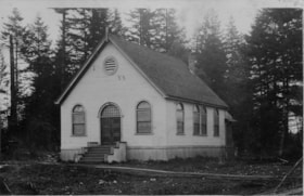
Jubilee Methodist Church
https://search.heritageburnaby.ca/link/archivedescription36018
- Repository
- City of Burnaby Archives
- Date
- 1909
- Collection/Fonds
- Burnaby Historical Society fonds
- Description Level
- Item
- Physical Description
- 1 photograph : sepia postcard ; 8 x 13 cm
- Scope and Content
- Photographic postcard of the Jubilee Methodist Church.
- Repository
- City of Burnaby Archives
- Date
- 1909
- Collection/Fonds
- Burnaby Historical Society fonds
- Subseries
- Ephemera subseries
- Physical Description
- 1 photograph : sepia postcard ; 8 x 13 cm
- Description Level
- Item
- Record No.
- 212-001
- Access Restriction
- No restrictions
- Reproduction Restriction
- No known restrictions
- Accession Number
- BHS1988-12
- Scope and Content
- Photographic postcard of the Jubilee Methodist Church.
- Media Type
- Photograph
- Notes
- Title based on contents of photograph
- Geographic Access
- Sussex Avenue
- Street Address
- 6050 Sussex Avenue
- Historic Neighbourhood
- Central Park (Historic Neighbourhood)
- Planning Study Area
- Marlborough Area

![Douglas Road, Burnaby, [1908] thumbnail](/media/hpo/_Data/_Archives_Images/_Unrestricted/371/449-009.jpg?width=280)
