Narrow Results By
![Sectional map and street directory of Vancouver : Dial map of greater Vancouver including adjacent municipalities, [ca. 1950] thumbnail](/media/hpo/_Data/_BVM_Cartographic_Material/2000/2000_0003_0011_001%20WEB.jpg?width=280)
Sectional map and street directory of Vancouver : Dial map of greater Vancouver including adjacent municipalities
https://search.heritageburnaby.ca/link/museumdescription8697
- Repository
- Burnaby Village Museum
- Date
- [ca. 1950]
- Collection/Fonds
- Burnaby Village Museum Map collection
- Description Level
- Item
- Physical Description
- 2 maps and 1 p. of textual records on 1 sheet : lithographic prints, col. ; 55.5 x 75 cm + 2 dials and 25 x 72 cm + directory on sheet 55.5 x 75 cm, folded to 28.5 x 12.5 cm
- Scope and Content
- Item is a sectional map and street directory titled "Dial Map of Greater Vancouver and adjacent Municipalities" with a map on one side titled "Dial Map of Greater Vancouver and Suburbs" including Vancouver, West Vancouver, North Vancouver and Burnaby and includes street car and bus lines, railways,…
- Repository
- Burnaby Village Museum
- Collection/Fonds
- Burnaby Village Museum Map collection
- Description Level
- Item
- Physical Description
- 2 maps and 1 p. of textual records on 1 sheet : lithographic prints, col. ; 55.5 x 75 cm + 2 dials and 25 x 72 cm + directory on sheet 55.5 x 75 cm, folded to 28.5 x 12.5 cm
- Material Details
- Scales 1:42240, 1:144823
- 2 alphabetic dials on narrow strips of paper attached to map by grommets
- Scope and Content
- Item is a sectional map and street directory titled "Dial Map of Greater Vancouver and adjacent Municipalities" with a map on one side titled "Dial Map of Greater Vancouver and Suburbs" including Vancouver, West Vancouver, North Vancouver and Burnaby and includes street car and bus lines, railways, hospitals, parks, block nos. and street indexes with two alphabetic dials, one for Vancouver, the other for New Westminster. The other side of the map includes a map of "Fraser Valley" along with a directory of Vancouver street car and bus routes, business blocks, public buildings, hospitals, bathing beaches, locations of Vancouver fire halls and Vancouver city schools.
- Creator
- Dominion Map and Blueprint Co.
- Publisher
- Sectional Map and Street Directory Company
- Geographic Access
- Vancouver
- Accession Code
- BV000.3.11
- Access Restriction
- No restrictions
- Reproduction Restriction
- No known restrictions
- Date
- [ca. 1950]
- Media Type
- Cartographic Material
- Scan Resolution
- 380
- Scan Date
- 22-Dec-2020
- Scale
- 100
- Notes
- Title based on contents of map
Images
![Sectional map and street directory of Vancouver : Dial map of greater Vancouver including adjacent municipalities, [ca. 1950] thumbnail](/media/hpo/_Data/_BVM_Cartographic_Material/2000/2000_0003_0011_001%20WEB.jpg)


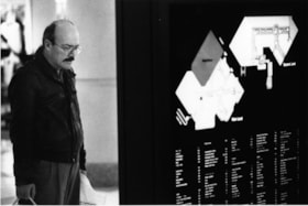
Metrotown mall directory
https://search.heritageburnaby.ca/link/archivedescription78792
- Repository
- City of Burnaby Archives
- Date
- December 24, 1995
- Collection/Fonds
- Burnaby NewsLeader photograph collection
- Description Level
- Item
- Physical Description
- 1 photograph : b&w ; 14 x 21 cm
- Scope and Content
- Photograph of an unidentified man standing in front of the Metrotown mall directory sign.
- Repository
- City of Burnaby Archives
- Date
- December 24, 1995
- Collection/Fonds
- Burnaby NewsLeader photograph collection
- Physical Description
- 1 photograph : b&w ; 14 x 21 cm
- Description Level
- Item
- Record No.
- 535-0109
- Access Restriction
- No restrictions
- Reproduction Restriction
- No reproduction permitted
- Accession Number
- 2012-11
- Scope and Content
- Photograph of an unidentified man standing in front of the Metrotown mall directory sign.
- Names
- Metrotown
- Media Type
- Photograph
- Photographer
- Bartel, Mario
- Notes
- Title based on contents of photograph
- Note in black ink on recto of photograph reads: "Bby NW pg 11 73% / Bartel Bby 3557 B"
- Trim marks and/or reproduction instructions on recto (scan is cropped)
Images
![Dover Bakery truck, [193- ?] thumbnail](/media/hpo/_Data/_BVM_Images/1985/1985_5759_0001_001.jpg?width=280)
Dover Bakery truck
https://search.heritageburnaby.ca/link/museumdescription1387
- Repository
- Burnaby Village Museum
- Date
- [193- ?]
- Collection/Fonds
- Burnaby Village Museum Photograph collection
- Description Level
- Item
- Physical Description
- 1 photograph : b&w
- Scope and Content
- Photograph of a truck with a sign on its window that reads, "Dover Bakery." The driver has his hand out the window to pat a dog sitting on the side skirt of the car. The 1937 British Columbia Directory lists a Dover Bakery at 3419 Dover Street in Burnaby. The driver of the truck has been identif…
- Repository
- Burnaby Village Museum
- Collection/Fonds
- Burnaby Village Museum Photograph collection
- Description Level
- Item
- Physical Description
- 1 photograph : b&w
- Scope and Content
- Photograph of a truck with a sign on its window that reads, "Dover Bakery." The driver has his hand out the window to pat a dog sitting on the side skirt of the car. The 1937 British Columbia Directory lists a Dover Bakery at 3419 Dover Street in Burnaby. The driver of the truck has been identified as Fordyce Smart, son of the baker (also named Fordyce).
- Names
- Dover Bakery
- Smart, Fordyce
- Accession Code
- BV985.5759.1
- Access Restriction
- No restrictions
- Reproduction Restriction
- No known restrictions
- Date
- [193- ?]
- Media Type
- Photograph
- Related Material
- This photograph is the original for copy print made for HV976.153.4
- Scan Resolution
- 600
- Scan Date
- 2024-01-23
- Notes
- Title based on contents of photograph
- Note in blue ink on verso of photograph reads: "F. Smart + 1930 truck"
Images
![Dover Bakery truck, [193- ?] thumbnail](/media/hpo/_Data/_BVM_Images/1985/1985_5759_0001_001.jpg)
![Dow General Store, [193-] thumbnail](/media/hpo/_Data/_BVM_Images/1976/1976_0062_0001_001.jpg?width=280)
Dow General Store
https://search.heritageburnaby.ca/link/museumdescription741
- Repository
- Burnaby Village Museum
- Date
- [193-]
- Collection/Fonds
- Burnaby Village Museum Photograph collection
- Description Level
- Item
- Physical Description
- 1 photograph : b&w ; 8.89 x 14.61 cm
- Scope and Content
- Photograph of a store with a large Coca Cola sign hanging by the second floor windows. The awning has lettering: "Ice Cream - Soft Drinks." By the door, there is a sign that reads "Post Office / Public Telephone / Box Cigars." On the display window, an advertisement sign for "Salada Tea" can be s…
- Repository
- Burnaby Village Museum
- Collection/Fonds
- Burnaby Village Museum Photograph collection
- Description Level
- Item
- Physical Description
- 1 photograph : b&w ; 8.89 x 14.61 cm
- Material Details
- An annotation in pencil is written on the back of the photograph
- Scope and Content
- Photograph of a store with a large Coca Cola sign hanging by the second floor windows. The awning has lettering: "Ice Cream - Soft Drinks." By the door, there is a sign that reads "Post Office / Public Telephone / Box Cigars." On the display window, an advertisement sign for "Salada Tea" can be seen. By the steps leading into the store, there is a large advertisement sign that reads "Wilson's Bachelor Cigar 10c." In front of the store is a paved road.
- Geographic Access
- Hastings Street
- Street Address
- 6669 Hastings Street
- Accession Code
- HV976.62.1
- Access Restriction
- No restrictions
- Reproduction Restriction
- No known restrictions
- Date
- [193-]
- Media Type
- Photograph
- Historic Neighbourhood
- Lochdale (Historic Neighbourhood)
- Scan Resolution
- 600
- Scan Date
- 2023-06-20
- Notes
- Title based on contents of photograph
- An annotation on the back of the photograph reads, "Dow General Store / Sperling & Hastings Approx / 1930's." The 1937 directory lists the name as "Dow's General Store" and the address as 6669 Hastings Street.
Images
![Dow General Store, [193-] thumbnail](/media/hpo/_Data/_BVM_Images/1976/1976_0062_0001_001.jpg)
![Dugald Campbell Patterson, Sr, [between 1910 and 1914] (date of original), copied 1977 thumbnail](/media/hpo/_Data/_BVM_Images/1977/1977_0099_0006_001.jpg?width=280)
Dugald Campbell Patterson, Sr
https://search.heritageburnaby.ca/link/museumdescription564
- Repository
- Burnaby Village Museum
- Date
- [between 1910 and 1914] (date of original), copied 1977
- Collection/Fonds
- Burnaby Village Museum Photograph collection
- Description Level
- Item
- Physical Description
- 1 photograph : b&w ; 20.32 x 25.4 cm print
- Scope and Content
- Photograph portrait of Dugald Campbell Patterson, Sr.
- Repository
- Burnaby Village Museum
- Collection/Fonds
- Burnaby Village Museum Photograph collection
- Description Level
- Item
- Physical Description
- 1 photograph : b&w ; 20.32 x 25.4 cm print
- Scope and Content
- Photograph portrait of Dugald Campbell Patterson, Sr.
- History
- Dugald Campbell Patterson Sr. arrived in Burnaby in 1894. He worked for Armstrong Morrison & Balfour and later became foreman boilermaker for the Vancouver Engineering Works. He was the first postmaster of Edmonds in 1909, and was elected a school trustee in 1912. He was a Director of the British Columbia Electric and Water Heat Company and was a member of the New Westminster Board of Trade. He founded an insurance and real estate company in Burnaby and New Westminster. Dugald Campbell Patterson Sr. was born in Partick, Scotland on January 2, 1860. He attended the Glasgow common school, and worked as a ship joiner at Barclay Curle & Company (founded in 1818) in Whiteinch, Scotland. After some years of study, he was employed in the Anchor Line Shipyards (founded in 1856) in Partick. Dugald arrived in Canada on July 1, 1884, and would soon add a second "T" to the spelling of his last name (changing it from "Paterson" to "Patterson"). He married Frances Mabel Webb on February 7, 1891. Together they helped form the Central Park Horticultural Society.Known for his expertise in the field of engineering, Dugald accepted a unique commission at the beginning of World War One. He travelled overseas to supervise a group of Canadians in the construction of submarines on the Clyde River in Glasgow. It was here that he sustained an injury which left him in a wheel chair. Upon his return home, he remained active in both municipal affairs and the arts. He developed a plan that would preserve ravines as parks in Burnaby, and he published a book of poetry. Dugald also served his communty through his membership in the Knights of Pythias,the Canadian Order of Forresters and the Home Reunion Association. Dugald died in Vancouver, BC on June 25, 1931. [Biography provided by Raymond Reitsma].
- Accession Code
- HV977.99.6
- Access Restriction
- No restrictions
- Reproduction Restriction
- May be restricted by third party rights
- Date
- [between 1910 and 1914] (date of original), copied 1977
- Media Type
- Photograph
- Scan Resolution
- 600
- Scan Date
- 2023-07-11
- Photographer
- Ritchie, Samuel J.
- Notes
- Title based on contents of photograph
- An annotation on the back of the photograph reads: "B. Paterson's [sic] father (Dougal [sic] Campbell Patterson). Owner Vulcan Iron Works, New Westminster, B.C. (He also started real estate business at Edmonds and K'way [Kingsway]."
- For more information on D.C. Patterson's family, see Michael Sone's book, "Pioneer Tales of Burnaby," pg. 60.
- The photographer Samuel J. Ritchie was active in New Westminster from 1910 to 1914. For reference, see David Mattison's Camera Workers: The British Columbia Photographic Directory, 1858-1950 - R - Volume 2 (1901-1950)
Images
![Dugald Campbell Patterson, Sr, [between 1910 and 1914] (date of original), copied 1977 thumbnail](/media/hpo/_Data/_BVM_Images/1977/1977_0099_0006_001.jpg)
![Fred Holdsworth and his wife in front of their house, [1912] thumbnail](/media/hpo/_Data/_BVM_Images/1977/198000120001.jpg?width=280)
Fred Holdsworth and his wife in front of their house
https://search.heritageburnaby.ca/link/museumdescription3029
- Repository
- Burnaby Village Museum
- Date
- [1912]
- Collection/Fonds
- Burnaby Village Museum Photograph collection
- Description Level
- Item
- Physical Description
- 1 photograph : b&w postcard ; 13.9 x 8.5 cm
- Scope and Content
- Photographic postcard of Fred Holdsworth and his wife standing outside their Neville Street Home. The house is two storeys with an attic with windows. The porch is elevated with steep stairs leading to the front door, which is on the second floor. They are both standing with their hands on their hi…
- Repository
- Burnaby Village Museum
- Collection/Fonds
- Burnaby Village Museum Photograph collection
- Description Level
- Item
- Physical Description
- 1 photograph : b&w postcard ; 13.9 x 8.5 cm
- Scope and Content
- Photographic postcard of Fred Holdsworth and his wife standing outside their Neville Street Home. The house is two storeys with an attic with windows. The porch is elevated with steep stairs leading to the front door, which is on the second floor. They are both standing with their hands on their hips. There are variant spellings of "Holdsworth" used in the notes in the accession file. They are "Houldsworth" and "Hallsworth." The 1937 British Columbia directory lists a Fred Houldsworth at 3345 Neville Street, Burnaby. The address was later renumbered 5249 Neville Street.
- Geographic Access
- Neville Street
- Street Address
- 5249 Neville Street
- Accession Code
- HV980.12.1
- Access Restriction
- No restrictions
- Reproduction Restriction
- May be restricted by third party rights
- Date
- [1912]
- Media Type
- Photograph
- Historic Neighbourhood
- Alta-Vista (Historic Neighbourhood)
- Planning Study Area
- Clinton-Glenwood Area
- Scan Resolution
- 600
- Scan Date
- 2023-09-12
- Notes
- Title based on contents of photograph
Images
![Fred Holdsworth and his wife in front of their house, [1912] thumbnail](/media/hpo/_Data/_BVM_Images/1977/198000120001.jpg)
![Holdsworth House on Neville Street, [1912] thumbnail](/media/hpo/_Data/_BVM_Images/1977/198000120002.jpg?width=280)
Holdsworth House on Neville Street
https://search.heritageburnaby.ca/link/museumdescription3030
- Repository
- Burnaby Village Museum
- Date
- [1912]
- Collection/Fonds
- Burnaby Village Museum Photograph collection
- Description Level
- Item
- Physical Description
- 1 photograph : sepia postcard ; 8.8 x 13.8 cm
- Scope and Content
- Photographic postcard of the Holdsworth house on Neville Street. The house is two storeys with an attic with windows. The porch is elevated with steep stairs leading to the front door, which is on the second floor. There is a woman standing in the porch, looking towards the photographer. Another ho…
- Repository
- Burnaby Village Museum
- Collection/Fonds
- Burnaby Village Museum Photograph collection
- Description Level
- Item
- Physical Description
- 1 photograph : sepia postcard ; 8.8 x 13.8 cm
- Scope and Content
- Photographic postcard of the Holdsworth house on Neville Street. The house is two storeys with an attic with windows. The porch is elevated with steep stairs leading to the front door, which is on the second floor. There is a woman standing in the porch, looking towards the photographer. Another house is visible right beside the Holdsworth house. There are variant spellings of "Holdsworth" used in the notes in the accession file. They are "Houldsworth" and "Hallsworth." The 1937 British Columbia directory lists a Fred Houldsworth at 3345 Neville Street, Burnaby. The address was later renumbered 5249 Neville Street.
- Geographic Access
- Neville Street
- Street Address
- 5249 Neville Street
- Accession Code
- HV980.12.2
- Access Restriction
- No restrictions
- Reproduction Restriction
- May be restricted by third party rights
- Date
- [1912]
- Media Type
- Photograph
- Historic Neighbourhood
- Alta-Vista (Historic Neighbourhood)
- Planning Study Area
- Clinton-Glenwood Area
- Scan Resolution
- 600
- Scan Date
- 2023-09-12
- Notes
- Title based on contents of photograph
Images
![Holdsworth House on Neville Street, [1912] thumbnail](/media/hpo/_Data/_BVM_Images/1977/198000120002.jpg)

Neville Street by Royal Oak
https://search.heritageburnaby.ca/link/museumdescription3031
- Repository
- Burnaby Village Museum
- Date
- 1912
- Collection/Fonds
- Burnaby Village Museum Photograph collection
- Description Level
- Item
- Physical Description
- 1 photograph : sepia postcard ; 8.8 x 13.9 cm
- Scope and Content
- Photographic postcard of Neville Street just off Royal Oak Avenue. The street is a dirt road lined with residential buildings on one side and eletric power poles on the other side. The Holdsworth house is seen being constructed on the left. There is scaffolding on the side of the building and a cle…
- Repository
- Burnaby Village Museum
- Collection/Fonds
- Burnaby Village Museum Photograph collection
- Description Level
- Item
- Physical Description
- 1 photograph : sepia postcard ; 8.8 x 13.9 cm
- Scope and Content
- Photographic postcard of Neville Street just off Royal Oak Avenue. The street is a dirt road lined with residential buildings on one side and eletric power poles on the other side. The Holdsworth house is seen being constructed on the left. There is scaffolding on the side of the building and a cleared lot beside the house. here are variant spellings of "Holdsworth" used in the notes in the accession file. They are "Houldsworth" and "Hallsworth." The 1937 British Columbia directory lists a Fred Houldsworth at 3345 Neville Street, Burnaby. The address was later renumbered 5249 Neville Street. An annotation on the back of the postcard reads: "Nevil [sic] Street - 1912 - Just off Royal Oak."
- Subjects
- Buildings - Residential - Houses
- Documentary Artifacts - Postcards
- Geographic Features - Roads
- Geographic Access
- Neville Street
- Royal Oak Avenue
- Accession Code
- HV980.12.3
- Access Restriction
- No restrictions
- Reproduction Restriction
- May be restricted by third party rights
- Date
- 1912
- Media Type
- Photograph
- Historic Neighbourhood
- Alta-Vista (Historic Neighbourhood)
- Planning Study Area
- Clinton-Glenwood Area
- Scan Resolution
- 600
- Scan Date
- 2023-09-12
- Notes
- Title based on contents of photograph
Images
