Narrow Results By
Digney Film 3 - Construction and opening of Digney bowling Alley, visit to Stanley Park and summer vacations
https://search.heritageburnaby.ca/link/museumdescription10678
- Repository
- Burnaby Village Museum
- Date
- [between 1955 and 1979] (date of original), copied 2019
- Collection/Fonds
- Digney Family fonds
- Description Level
- File
- Physical Description
- 1 video recording (mp4) (20 min., 30 sec.) : digital, 16 fps, col., si.
- Scope and Content
- File consists of a film compliation of short clips created by Andy Digney and his son Ernest "Dig" Digney. Film compilation documents the construction, opening and a tournament of the Digney Bowling Alley located at 6521 Bonsor Avenue in Burnaby along with Digney family outings at Stanley Park in V…
- Repository
- Burnaby Village Museum
- Collection/Fonds
- Digney Family fonds
- Description Level
- File
- Physical Description
- 1 video recording (mp4) (20 min., 30 sec.) : digital, 16 fps, col., si.
- Scope and Content
- File consists of a film compliation of short clips created by Andy Digney and his son Ernest "Dig" Digney. Film compilation documents the construction, opening and a tournament of the Digney Bowling Alley located at 6521 Bonsor Avenue in Burnaby along with Digney family outings at Stanley Park in Vancouver and vacations at Birch Bay, Washington State and Okanagan Lake.
- Creator
- Digney, Andy
- Names
- Digney, Andy
- Swan, Sydney
- Digney Bowling Alley
- Digney, Drew
- Digney, Joyce
- Digney, Bruce
- Digney, Paul
- Geographic Access
- Bonsor Avenue
- Street Address
- 6521 Bonsor Avenue
- Accession Code
- BV019.18.5
- Access Restriction
- No restrictions
- Reproduction Restriction
- No known restrictions
- Date
- [between 1955 and 1979] (date of original), copied 2019
- Media Type
- Moving Images
- Historic Neighbourhood
- Central Park (Historic Neighbourhood)
- Planning Study Area
- Maywood Area
- Notes
- Title based on contents of film compilation
- 4 film segments from this compilation are described at item level and available for viewing on Heritage Burnaby.
- Contact Burnaby Village Museum to view entire content
Water Courses Act - Hill, Plester and Mervyn
https://search.heritageburnaby.ca/link/archivedescription682
- Repository
- City of Burnaby Archives
- Date
- 1905
- Collection/Fonds
- City Council and Office of the City Clerk fonds
- Description Level
- File
- Physical Description
- Textual record
- Scope and Content
- File contains agreements made between he Corporation of the District of Burnaby and Annie Sarah Hill, Henry Pletser, and John and James Mervyn about the construction of a culvert. It also includes an agreement with L. Claude Hill for the construction of a ditch in the Burnaby Lake area.
- Repository
- City of Burnaby Archives
- Date
- 1905
- Collection/Fonds
- City Council and Office of the City Clerk fonds
- Physical Description
- Textual record
- Description Level
- File
- Record No.
- 2407
- Accession Number
- 2001-02
- Scope and Content
- File contains agreements made between he Corporation of the District of Burnaby and Annie Sarah Hill, Henry Pletser, and John and James Mervyn about the construction of a culvert. It also includes an agreement with L. Claude Hill for the construction of a ditch in the Burnaby Lake area.
- Media Type
- Textual Record
Burnaby Centennial Committee "Heritage Park" Proposal
https://search.heritageburnaby.ca/link/museumdescription3867
- Repository
- Burnaby Village Museum
- Date
- [1971]
- Collection/Fonds
- Donald Copan collection
- Description Level
- File
- Physical Description
- 6 p. of textual records
- Scope and Content
- Proposal submitted by Hopping / Kovach / Grinnel Design Consultants Ltd. for the construction of Heritage Park.
- Repository
- Burnaby Village Museum
- Collection/Fonds
- Donald Copan collection
- Description Level
- File
- Physical Description
- 6 p. of textual records
- Scope and Content
- Proposal submitted by Hopping / Kovach / Grinnel Design Consultants Ltd. for the construction of Heritage Park.
- Names
- Burnaby Village Museum
- Accession Code
- BV005.54.784
- Access Restriction
- Restricted access
- Reproduction Restriction
- May be restricted by third party rights
- Date
- [1971]
- Media Type
- Textual Record
- Historic Neighbourhood
- Burnaby Lake (Historic Neighbourhood)
- Planning Study Area
- Morley-Buckingham Area
- Notes
- Title based on content of file
Burnaby - Images of Change - slide presentation
https://search.heritageburnaby.ca/link/museumdescription13116
- Repository
- Burnaby Village Museum
- Date
- February 1978 (date of slide show)
- Collection/Fonds
- Century Park Museum Association fonds
- Description Level
- File
- Physical Description
- 52 photographs : col. slides ; 35 mm
- Scope and Content
- File consists of fifty two slides used for a Hertiage Village Museum presentation titled "Burnaby - Images of Change". The slides were part of a resource kit prepared by "Heritage Village Education" and consist of copies of historical photographs taken between 1891 and 1931. Numbered slides includ…
- Repository
- Burnaby Village Museum
- Collection/Fonds
- Century Park Museum Association fonds
- Description Level
- File
- Physical Description
- 52 photographs : col. slides ; 35 mm
- Scope and Content
- File consists of fifty two slides used for a Hertiage Village Museum presentation titled "Burnaby - Images of Change". The slides were part of a resource kit prepared by "Heritage Village Education" and consist of copies of historical photographs taken between 1891 and 1931. Numbered slides include; "1) Title slide; 2) Mr. and Mrs. S. Shepard Samuel, 1904; 3) The McMurray Family 1907; 4) The Bateman Family; 5) Mr. Alexis Shaw; 6) Dr. R. Ellen Walker; 7) Home of Col. J. Ward on the north side of Burnaby Lake; 8) Cameron home located on New Westminster Road - now Kingsway; 9) Home of L.C. Hill, "Brookfield" 1894; 10) Bernard Hill's home on Burnaby Lake, 1910; 11) Bateman Family residence under construction, 1920; 12) Bateman residence known as "Elworth House" completed in 1922; 13) Early logging operaton in 1890 using oxen and a skid road; 14) Steam donkey and loggers; 15) Cord wood delivery in 1925; 16) L.C. Hill's strawberry farm in 1895; 17) Strawberries being delivered to New Westminster in 1896; 18) Haying operation on Douglas Road in 1906; 19) 1906 haying scene in the Burnaby Lake area; 20) Kingsway store of Mr. C.B. Button, 1904; 21) Model Grocery stroe at Hastings and Sperling in 1920; 22) Dow Grocery store at Hastings and Sperling in 1920; 23) Zebulon Frank's hardware store in 1887 - Vancouver; 24) Inside of a phography shop, 1910- Vancouver; Burnaby's first Municipal Council, 1892; 25) Burnaby's first Municipal Hall opened in 1899; 27) Presbyterian Church in Westminster Road at Central Park, 1896; 28) St. John the Devine Church in 1896; 29) First school in Burnaby near Edmonds and Douglas Road; 30) School Children, 1904; 31) Miss Harriett Woodward's private school near Deer Lake, 1907; 32) Gilmore Avenue School, March 17, 1920; 33) Pupils of Edmonds Street School, 1922; 34) L.C. Hill Family picnic in July 1892; 35) Lewis Family picnic in 1910; 36) Catch of fish from Deer Lake, 1910; 37) Hunting scene in Burnaby area, 1910; 38) Burnaby's first lawn bowling green, 1907; 39) Skating on Deer Lake, 1912; 40) Skating party on Deer Lake in the winter of 1921; 41) Boating on Deer Lake, 1922; 42) Burnaby's first May Day celebration in 1925; 43) May Day, 1926; 44) Westminster to Vancouver Tram, 1892; 45) Interurban powerhouse at Edmonds and Highland Park, 1891; 46) Douglas Road, 1895; 47) Horse team hauling crushed rock for Douglas Road, 1911; 48) Horse and cart passing cleared land; 49) Cyclist, 1912; 50) The Opening of the paved road (Kingsway), 1913; 51) Painting the white line on Kingsway, 1928; 52) First auto in Burnaby circa 1905; 53) Alfred Bingham and his model T. Ford, 1931".
- Creator
- Burnaby Village Museum
- Subjects
- Buildings - Civic - Museums
- Names
- Burnaby Village Museum
- Accession Code
- BV020.5.734
- Access Restriction
- No restrictions
- Reproduction Restriction
- No known restrictions
- Date
- February 1978 (date of slide show)
- Media Type
- Photograph
- Notes
- Title based on contents of file
- Original photograph content ranges between 1891 and 1931.
- Description of slides taken from "Slide indentification" list BV020.5.735
- See also audio recording commentary BV020.5.733
Burnaby Mountain Golf Course photographs
https://search.heritageburnaby.ca/link/archivedescription66715
- Repository
- City of Burnaby Archives
- Date
- 1965-1970
- Collection/Fonds
- Robert Bailey fonds
- Description Level
- File
- Physical Description
- 39 photographs : col. slides ; 35 mm
- Scope and Content
- Photographs of the construction and opening of the Burnaby Mountain Golf Course, taken by Robert Bailey.
- Repository
- City of Burnaby Archives
- Date
- 1965-1970
- Collection/Fonds
- Robert Bailey fonds
- Physical Description
- 39 photographs : col. slides ; 35 mm
- Description Level
- File
- Record No.
- 526-001
- Access Restriction
- No restrictions
- Reproduction Restriction
- No restrictions
- Accession Number
- 2011-14
- Scope and Content
- Photographs of the construction and opening of the Burnaby Mountain Golf Course, taken by Robert Bailey.
- Subjects
- Recreational Activities - Golf
- Names
- Bailey, Robert
- Media Type
- Photograph
- Photographer
- Bailey, Robert
- Notes
- Title based on contents of file
- Note on verso of 526-001-4 reads: "Burnaby clearing"
- Note on verso of 526-001-14 reads: "Ravine Burnaby"
- Note on verso of 526-001-17 reads: "Burnaby GClub / Apr 26 68"
- Note on verso of 526-001-29 reads: "#8 Tee Burnaby / Apr 26 68"
- Date on stamp on verso of 526-001-30 reads: "Mar 69V3"
- Note on recto of 526-001-30 reads: "Burnaby in Fall #7"
- Note on verso of 526-001-31 reads: "Burnaby Lake & Clubhouse / April [?] / 68"
- Note on verso of 526-001-32 reads: "Burnaby Const[?] / Bob Bailey - Emilio"
- Date stamp on verso of 526-001-33:526-001-39 reads: "May 69V2"
- Geographic Access
- Burnaby Mountain Conservation Area
Images

Century Park Museum Association papers
https://search.heritageburnaby.ca/link/archivedescription58449
- Repository
- City of Burnaby Archives
- Date
- 1971
- Collection/Fonds
- Burnaby Historical Society fonds
- Description Level
- File
- Physical Description
- 1 file of textual records
- Scope and Content
- File consists of a report entitled "Construction and Display Programme (Master Plan) / Heritage Park Burnaby, B.C." produced by "Hopping / Kovach / Grinnell design consultants ltd." (a letter of introduction is enclosed) as well as a map of the proposed site.
- Repository
- City of Burnaby Archives
- Date
- 1971
- Collection/Fonds
- Burnaby Historical Society fonds
- Physical Description
- 1 file of textual records
- Description Level
- File
- Record No.
- MSS085-006
- Accession Number
- BHS1998-11
- Scope and Content
- File consists of a report entitled "Construction and Display Programme (Master Plan) / Heritage Park Burnaby, B.C." produced by "Hopping / Kovach / Grinnell design consultants ltd." (a letter of introduction is enclosed) as well as a map of the proposed site.
- Media Type
- Textual Record
- Notes
- Title based on contents of file
Ditches and water courses
https://search.heritageburnaby.ca/link/archivedescription662
- Repository
- City of Burnaby Archives
- Date
- 1908
- Collection/Fonds
- City Council and Office of the City Clerk fonds
- Description Level
- File
- Physical Description
- Textual record and cartographic material
- Scope and Content
- File contains reports, correspondence, declarations and appeals related to the construction of ditches and water courses as well as the application to construct ditches made by Ida I. Dow, William Buckoll, and O. Goodacre. File also includes white linen plan of "Proposed Ditch in lot 153, G1, NWD…
- Repository
- City of Burnaby Archives
- Date
- 1908
- Collection/Fonds
- City Council and Office of the City Clerk fonds
- Physical Description
- Textual record and cartographic material
- Description Level
- File
- Record No.
- 2387
- Accession Number
- 2001-02
- Scope and Content
- File contains reports, correspondence, declarations and appeals related to the construction of ditches and water courses as well as the application to construct ditches made by Ida I. Dow, William Buckoll, and O. Goodacre. File also includes white linen plan of "Proposed Ditch in lot 153, G1, NWD" located at M9-B-3-20.
- Media Type
- Textual Record
- Cartographic Material
- Notes
- A map of Proposed Ditch in Lot 153 : M9-B-3-20
Ditches and water courses - Ceperley and Byrne
https://search.heritageburnaby.ca/link/archivedescription683
- Repository
- City of Burnaby Archives
- Date
- 1908
- Collection/Fonds
- City Council and Office of the City Clerk fonds
- Description Level
- File
- Physical Description
- Textual record
- Scope and Content
- File contains correspondence and applications for the construction of ditches in DL 79, made by Henry T. Ceperley and Peter Byrne.
- Repository
- City of Burnaby Archives
- Date
- 1908
- Collection/Fonds
- City Council and Office of the City Clerk fonds
- Physical Description
- Textual record
- Description Level
- File
- Record No.
- 2408
- Accession Number
- 2001-02
- Scope and Content
- File contains correspondence and applications for the construction of ditches in DL 79, made by Henry T. Ceperley and Peter Byrne.
- Media Type
- Textual Record
Ditches and water courses - Fraser Valley nurseries
https://search.heritageburnaby.ca/link/archivedescription681
- Repository
- City of Burnaby Archives
- Date
- 1909
- Collection/Fonds
- City Council and Office of the City Clerk fonds
- Description Level
- File
- Physical Description
- Textual record
- Scope and Content
- File contains agreement made between the Corporation of the District of Burnaby and the Fraser Valley Nurseries Co., Ltd., pertaining to the construction of a ditch on Nursery Road.
- Repository
- City of Burnaby Archives
- Date
- 1909
- Collection/Fonds
- City Council and Office of the City Clerk fonds
- Physical Description
- Textual record
- Description Level
- File
- Record No.
- 2406
- Accession Number
- 2001-02
- Scope and Content
- File contains agreement made between the Corporation of the District of Burnaby and the Fraser Valley Nurseries Co., Ltd., pertaining to the construction of a ditch on Nursery Road.
- Media Type
- Textual Record
Ditches and water courses - Mercer's application
https://search.heritageburnaby.ca/link/archivedescription680
- Repository
- City of Burnaby Archives
- Date
- 1908-1911
- Collection/Fonds
- City Council and Office of the City Clerk fonds
- Description Level
- File
- Physical Description
- Textual record
- Scope and Content
- File contains application made by Benn Mercer for the construction of a ditch on his property (DL 161, group 1).
- Repository
- City of Burnaby Archives
- Date
- 1908-1911
- Collection/Fonds
- City Council and Office of the City Clerk fonds
- Physical Description
- Textual record
- Description Level
- File
- Record No.
- 2405
- Accession Number
- 2001-02
- Scope and Content
- File contains application made by Benn Mercer for the construction of a ditch on his property (DL 161, group 1).
- Media Type
- Textual Record
Edmonds waterworks
https://search.heritageburnaby.ca/link/archivedescription367
- Repository
- City of Burnaby Archives
- Date
- 1909-1911
- Collection/Fonds
- City Council and Office of the City Clerk fonds
- Description Level
- File
- Physical Description
- Textual record
- Scope and Content
- File contains agreements, leases, reports and correspondence regarding the construction of a water works station in the Edmonds district.
- Repository
- City of Burnaby Archives
- Date
- 1909-1911
- Collection/Fonds
- City Council and Office of the City Clerk fonds
- Physical Description
- Textual record
- Description Level
- File
- Record No.
- 2060
- Accession Number
- 2001-02
- Scope and Content
- File contains agreements, leases, reports and correspondence regarding the construction of a water works station in the Edmonds district.
- Media Type
- Textual Record
- Notes
- For related records see also files 6-3-2-6 and 6-3-2-7.
Roads - Capitol Hill Land Co.
https://search.heritageburnaby.ca/link/archivedescription883
- Repository
- City of Burnaby Archives
- Date
- 1909
- Collection/Fonds
- City Council and Office of the City Clerk fonds
- Description Level
- File
- Physical Description
- Textual record
- Scope and Content
- File contains correspondence regarding the road construction and maintenance on Capitol Hill.
- Repository
- City of Burnaby Archives
- Date
- 1909
- Collection/Fonds
- City Council and Office of the City Clerk fonds
- Physical Description
- Textual record
- Description Level
- File
- Record No.
- 2647
- Accession Number
- 2001-02
- Scope and Content
- File contains correspondence regarding the road construction and maintenance on Capitol Hill.
- Media Type
- Textual Record
Royal Bank building research and correspondence
https://search.heritageburnaby.ca/link/museumdescription18549
- Repository
- Burnaby Village Museum
- Date
- 1974-1993
- Collection/Fonds
- Burnaby Village Museum fonds
- Description Level
- File
- Physical Description
- 2 cm of textual records
- Scope and Content
- File consists of research and correspondence pertaining to the history of the Royal Bank along with information and correspondence regarding the Royal Bank management plan; restoration; construction of a basement; press releases and invitation lists for the opening in May 1977.
- Repository
- Burnaby Village Museum
- Collection/Fonds
- Burnaby Village Museum fonds
- Series
- Royal Bank exhibit series
- Description Level
- File
- Physical Description
- 2 cm of textual records
- Scope and Content
- File consists of research and correspondence pertaining to the history of the Royal Bank along with information and correspondence regarding the Royal Bank management plan; restoration; construction of a basement; press releases and invitation lists for the opening in May 1977.
- Names
- Royal Bank of Canada
- Accession Code
- BV022.1.3
- Access Restriction
- Subject to FIPPA
- Reproduction Restriction
- Reproductions subject to FIPPA
- Date
- 1974-1993
- Media Type
- Textual Record
- Notes
- Title based on contents of file
Tenders for road debentures purchase
https://search.heritageburnaby.ca/link/archivedescription362
- Repository
- City of Burnaby Archives
- Date
- 1908-1909
- Collection/Fonds
- City Council and Office of the City Clerk fonds
- Description Level
- File
- Physical Description
- Textual record
- Scope and Content
- File contains correspondence and offers for purchase of road debentures which were sold by the Corporation of the District of Burnaby in order to raise funds for road construction.
- Repository
- City of Burnaby Archives
- Date
- 1908-1909
- Collection/Fonds
- City Council and Office of the City Clerk fonds
- Physical Description
- Textual record
- Description Level
- File
- Record No.
- 2055
- Accession Number
- 2001-02
- Scope and Content
- File contains correspondence and offers for purchase of road debentures which were sold by the Corporation of the District of Burnaby in order to raise funds for road construction.
- Media Type
- Textual Record
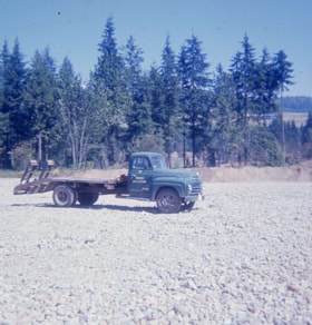
![Village church, [1973] thumbnail](/media/Hpo/_Data/_Archives_Images/_Unrestricted/371/462-001-7.jpg?width=280)
Village church
https://search.heritageburnaby.ca/link/archivedescription38562
- Repository
- City of Burnaby Archives
- Date
- [1973]
- Collection/Fonds
- Burnaby Historical Society fonds
- Description Level
- File
- Physical Description
- 18 photographs : col. slides (Kodachrome)
- Scope and Content
- Photographs of the construction of the church at Burnaby Village Museum.
- Repository
- City of Burnaby Archives
- Date
- [1973]
- Collection/Fonds
- Burnaby Historical Society fonds
- Subseries
- South Burnaby Men's Club subseries
- Physical Description
- 18 photographs : col. slides (Kodachrome)
- Description Level
- File
- Record No.
- 462-001
- Access Restriction
- No restrictions
- Reproduction Restriction
- Reproduce for fair dealing purposes only
- Accession Number
- BHS2004-03
- Scope and Content
- Photographs of the construction of the church at Burnaby Village Museum.
- Subjects
- Buildings - Religious - Churches
- Names
- Burnaby Village Museum
- Media Type
- Photograph
- Geographic Access
- Deer Lake Avenue
- Street Address
- 6501 Deer Lake Avenue
- Historic Neighbourhood
- Burnaby Lake (Historic Neighbourhood)
- Planning Study Area
- Morley-Buckingham Area
Images
![Village church, [1973] thumbnail](/media/Hpo/_Data/_Archives_Images/_Unrestricted/371/462-001-7.jpg)
![Survey and Subdivision plans in New Westminster District Group 1 – Burnaby
, [1861]-[1910] thumbnail](/media/hpo/_Data/_BVM_Cartographic_Material/1977/1977_0093_0019a_001.jpg?width=280)
Survey and Subdivision plans in New Westminster District Group 1 – Burnaby
https://search.heritageburnaby.ca/link/museumdescription6988
- Repository
- Burnaby Village Museum
- Date
- [1861]-[1910]
- Collection/Fonds
- Burnaby Village Museum Map collection
- Description Level
- File
- Physical Description
- 14 plans : 3 plans : black ink on paper hand col. + 7 plans : black ink on paper + 4 plans : graphite on paper mounted on 2 sides of cardboard 76 x 102 cm
- Scope and Content
- Item consists of a large board of four New Westminster District Gp 1 - subdivision plans mounted on one side and ten New Westminster District Gp 1 - subdivision plans mounted on the other side. Side A: 1. "Plan /of / Lots 166A, 166 and 167 /, Gr.1, N.W.D. / Showing Misconstructed Roads in Gree…
- Repository
- Burnaby Village Museum
- Collection/Fonds
- Burnaby Village Museum Map collection
- Description Level
- File
- Physical Description
- 14 plans : 3 plans : black ink on paper hand col. + 7 plans : black ink on paper + 4 plans : graphite on paper mounted on 2 sides of cardboard 76 x 102 cm
- Material Details
- Scales [between 1:2376 and 1:7920]
- Index number on edge of board reads: "19"
- Scope and Content
- Item consists of a large board of four New Westminster District Gp 1 - subdivision plans mounted on one side and ten New Westminster District Gp 1 - subdivision plans mounted on the other side. Side A: 1. "Plan /of / Lots 166A, 166 and 167 /, Gr.1, N.W.D. / Showing Misconstructed Roads in Green / 5 chs = 1 in.". (plan is drawn in black ink and hand coloured in red, green and orange ink). A section in the centre of the plan is coloured in red ink and identified as "C.S. Richmond" running from the North Arm of Fraser River to Wiggins Road and divided by "New Wiggins Rd. (as gazetted)" (coloured in orange ink) and two"Constructed Road(s)" (coloured in green ink). Plan is initialed by: "RB" [sic] (in blue pencil crayon) 2. Plan of / Subdivision of / Lot 166 / Group One / New Westminster District / Scale 4 chs = 1 in. / Map No 524". Plan is drawn in graphite and signed by "Surrig [sic] Welhams [sic] / P.L.S." Plan is initialed by: "RB" [sic] (in blue pencil crayon) 3. Plan of "Survey / of Highway / For / Burnaby Council / in / Lots 13 _14 / Group One / Scale 4 chs = 1 in." Signed by "Albert J. Hill, P.L.S." Caribou Street and Caribou Road run through the centre of the plan. Plan is stamped: "Albert J. Hill, Civil Engineer / and / Provincial Land Surveyor, / New Westminster, / B.C.". Plan is initialed by: "RB" [sic] (in blue pencil crayon) 4. A Plan of Lots 166A, 166 and 167, Group One, New Westminster District (drawn in graphite). A section in the centre of the plan is identified as "C.S. Richmond" running from the North Arm of Fraser River and divided by "New Wiggins Rd. (as gazetted)" and two "Constructed Road(s)". Plan is initialed by: "RB" [sic] (in blue pencil crayon) Side B: 1. Small plan drawn in black ink (no title) identifying lots north of the "North Arm" of the Fraser River. Lots identified include: Lot 99, Lot 98, Lot 157, Lot 158, Lot 163, Lot 162, Lot 159, Lot 163, Lot 162, Lot 165, Lot 166A, Lot 155B, Lot 155A and Lot 159. "Scale 40 chains to one inch" . Plan is initialed by: "RB" [sic] (in blue pencil crayon) (Geographic location: Burnaby) 2. Small plan drawn in black ink (no title) identifying lots north of the North Arm of the Fraser River as "Lots 155, 155A, 155B, 155C, 162, 163, 164, 165, 166A and 167". Plan is initialed by: "RB" [sic] (in blue pencil crayon) (Geographic location: Burnaby) 3. Small plan drawn in black ink (no title) which identifies "Lot 151 / Reserve/ for / Race Course"; "Reserve / 64 A / L. 152 G.1"; and other Lots: 32, 33, 34, 35, 36, 38, 39. The plan is signed "Surveyor G.Turn [sic] July / 61 / from Vol 40 R.L. notes [sic]" Plan is stamped: "Albert J. Hill, Civil Engineer / and / Provincial Land Surveyor, / New Westminster, / B.C." Plan is initialed by: "RB" [sic] (in blue pencil crayon) (Geographic location: Burnaby) 4. Small plan drawn in black in with faded red colouring on centre lot identified as "Lot 34" running north from "Vancouver Road" . Plan is stamped: "Albert J. Hill, Civil Engineer / and / Provincial Land Surveyor, / New Westminster, / B.C." Plan is initialed by: "RB" [sic] (in blue pencil crayon) (Geographic location: Burnaby) 5. Plan drawn in graphite and identified as "Lot 98, Gr.1," along with the intials "RB" [sic] (both are handwritten in blue crayon pencil on top of plan) The B.C.E.Railway is identified running through the plan along with Jubilee Road and Royal Oak Road. The plan is signed with the name "Wm. Murray" and the Plan is stamped: "Albert J. Hill, Civil Engineer / and / Provincial Land Surveyor, / New Westminster, / B.C.". (Geographic location: Burnaby) 6. Plan drawn in graphite identified as "Port Lot 13, Gr.1" along with the intials "RB" [sic] (both are handwritten in blue crayon pencil on top of plan) Plan is stamped: "Albert J. Hill, Civil Engineer / and / Provincial Land Surveyor, / New Westminster, / B.C.". (Geographic location: Burnaby) 7.Plan drawn in black ink and identified as "Lot 98 G.1" along with the intials "RB" [sic] (both are handwritten in blue crayon pencil on top of plan). A "Road Reservation" is identified running north between "Electric Tramway" and connecting with "Royal Oak Road". Plan is stamped: "Albert J. Hill, Civil Engineer / and / Provincial Land Surveyor, / New Westminster, / B.C." (Geographic location: Burnaby) 8. Plan drawn in black ink and divided into two sections, the upper plan is identified as "Portion / Lots 100 / area / 101, Gr.1" and the lower plan is identified as "Portion L. 3 G. 1" along with the intials "RB" [sic] (these identifiers are handwritten in blue crayon pencil on top of the plan). Portions of Lot 100 and Lot 101 are each divided into 6 sections and the Portion of Lot 3 plan is divided into 24 sections. The plan includes a note in black ink that reads: " Received from Wm Fromme [sic] / from Wm. Trapp / Nov. 28, 1895 / A. J. T...[sic]". (Geographic location: Burnaby) 9. Plan drawn in black ink (no title) identifying soil, buildings and geographic features in southern Burnaby. The plan is bordered by "New Westminster City" (Tenth Avenue and DL 172) to the south east and DL 173 to the south, DL 158 to the west and the B.C.E. Tramway to the north. Plan includes District Lots: 155A, 158, 159, 171, 160, 53 and 95 and identifies soil, marshland and ravines throughout. Plan identifies the following features: a "Team Road" running through Lots 158 and 159 along with "Fair Orchard Soil / Even Surface Throughout / No Ravines", "Gravel and Shingle" (bottom of Lot 158), "North Arm Road" crossing "Byrne Road" and connecting with "Power House Road" which runs north to connect with "Highland Park Station" and the B.C.E. Tramway, "Power Ho" in the northeast corner of DL 160, a "Brook" connected with a "Deep Ravine" running between DL 53, DL 95 and DL 160 along with "Good Soil" and "Fair Orchard Soil" identified nearby in DL 95. Scale is identified as "10 chs = 1 in." Plan is stamped: "Albert J. Hill, Civil Engineer / and / Provincial Land Surveyor, / New Westminster, / B.C." Plan is initialed by: "RB" [sic] (in blue pencil crayon) (Geographic location: Burnaby) 10. Plan drawn in black ink (no title) with Burnaby Lake and Deer Lake at the centre. The plan is bordered by the following District Lots identified as: 117, 118 and 68 to the west, Lots 80, 79 and 85 to the southwest, Lots 11, 13, and 1 (City of New Westminster) to the south east, the North Road boundary to the east and Lots 8, 56, 57, 59, and 136 to the North. The lower right hand corner of the plan has a small inset which reads: "Burnaby Lake" and "Page 19 R.B. Notes". Plan is initialed by: "RB" [sic] (in blue pencil crayon) (Geographic location: Burnaby)
- Creator
- Hill, Albert James
- Accession Code
- HV977.93.19
- Access Restriction
- No restrictions
- Reproduction Restriction
- No known restrictions
- Date
- [1861]-[1910]
- Media Type
- Cartographic Material
- Scan Resolution
- 300
- Scale
- 72
- Notes
- Title based on contents of file
- Scale is measured in chains. (One chain equals 792 inches)
- The term "Lot" can also refer to a "District Lot”
- Some plans are stamped: "Albert J. Hill, Civil Engineer / and / Provincial Land Surveyor, / New Westminster, / B.C." and intialed: "RB" [sic]
Images
![Survey and Subdivision plans in New Westminster District Group 1 – Burnaby
, [1861]-[1910] thumbnail](/media/hpo/_Data/_BVM_Cartographic_Material/1977/1977_0093_0019a_001.jpg)

Ditches and water courses (Sprott)
https://search.heritageburnaby.ca/link/archivedescription668
- Repository
- City of Burnaby Archives
- Date
- 1908
- Collection/Fonds
- City Council and Office of the City Clerk fonds
- Description Level
- File
- Physical Description
- Textual records, cartographic material and architectural material
- Scope and Content
- File contains correspondence, certificates signed by the District Engineer attesting to the fact that ditches were constructed according to the Ditches and Waterworks Act, as well as notices to residents that ditches were to be built along their property. File also includes 2 blueprint plans and 1…
- Repository
- City of Burnaby Archives
- Date
- 1908
- Collection/Fonds
- City Council and Office of the City Clerk fonds
- Physical Description
- Textual records, cartographic material and architectural material
- Description Level
- File
- Record No.
- 2393
- Accession Number
- 2001-02
- Scope and Content
- File contains correspondence, certificates signed by the District Engineer attesting to the fact that ditches were constructed according to the Ditches and Waterworks Act, as well as notices to residents that ditches were to be built along their property. File also includes 2 blueprint plans and 1 linen map of DL 79.
- Notes
- Plans/maps are located in file and have not been moved to map case.