
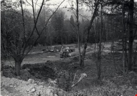
Construction Site near Salish Court
https://search.heritageburnaby.ca/link/archivedescription79039
- Repository
- City of Burnaby Archives
- Date
- September 27, 1976
- Collection/Fonds
- Burnaby Public Library Contemporary Visual Archive Project
- Description Level
- Item
- Physical Description
- 1 photograph : b&w ; 11 x 16 cm mounted on cardboard
- Scope and Content
- Photograph shows a view of a construction site taken from 9304 Salish Court Tower West.
- Repository
- City of Burnaby Archives
- Date
- September 27, 1976
- Collection/Fonds
- Burnaby Public Library Contemporary Visual Archive Project
- Physical Description
- 1 photograph : b&w ; 11 x 16 cm mounted on cardboard
- Description Level
- Item
- Record No.
- 556-107
- Access Restriction
- No restrictions
- Reproduction Restriction
- Reproduce for fair dealing purposes only
- Accession Number
- 2013-13
- Scope and Content
- Photograph shows a view of a construction site taken from 9304 Salish Court Tower West.
- Subjects
- Construction
- Media Type
- Photograph
- Photographer
- Campbell, Peg
- Notes
- Scope note taken directly from BPL photograph description.
- 1 b&w copy negative : 10 x 12.5 cm accompanying
- Geographic Access
- Salish Court
- Street Address
- 9304 Salish Court
- Historic Neighbourhood
- Burquitlam (Historic Neighbourhood)
- Planning Study Area
- Cameron Area
Images

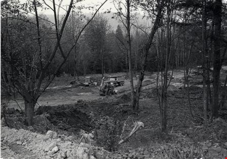
Construction site on Still Creek Street
https://search.heritageburnaby.ca/link/archivedescription79007
- Repository
- City of Burnaby Archives
- Date
- October 23, 1976
- Collection/Fonds
- Burnaby Public Library Contemporary Visual Archive Project
- Description Level
- Item
- Physical Description
- 1 photograph : b&w ; 11 x 16 cm mounted on cardboard
- Scope and Content
- Photograph shows trucks and earthmoving machinery at a construction site in the 9700 Block Still Creek Street.
- Repository
- City of Burnaby Archives
- Date
- October 23, 1976
- Collection/Fonds
- Burnaby Public Library Contemporary Visual Archive Project
- Physical Description
- 1 photograph : b&w ; 11 x 16 cm mounted on cardboard
- Description Level
- Item
- Record No.
- 556-087
- Access Restriction
- No restrictions
- Reproduction Restriction
- Reproduce for fair dealing purposes only
- Accession Number
- 2013-13
- Scope and Content
- Photograph shows trucks and earthmoving machinery at a construction site in the 9700 Block Still Creek Street.
- Subjects
- Construction
- Media Type
- Photograph
- Photographer
- Campbell, Peg
- Notes
- Scope note taken directly from BPL photograph description.
- 1 b&w copy negative : 10 x 12.5 cm accompanying
- Geographic Access
- Still Creek Avenue
Images

Quesnel Greene Construction
https://search.heritageburnaby.ca/link/archivedescription79014
- Repository
- City of Burnaby Archives
- Date
- October 23, 1976
- Collection/Fonds
- Burnaby Public Library Contemporary Visual Archive Project
- Description Level
- Item
- Physical Description
- 1 photograph : b&w ; 11 x 16 cm mounted on cardboard
- Scope and Content
- Photograph shows Quesnel Greene construction sign located at the corner of Aquarius Drive and Centaurus Circle. The Quesnel Green Co-operative Housing project was designed by Neinhaker/Irwin Associates and was built by Dunhill Development Corporation Ltd. It was owned by the Government of British…
- Repository
- City of Burnaby Archives
- Date
- October 23, 1976
- Collection/Fonds
- Burnaby Public Library Contemporary Visual Archive Project
- Physical Description
- 1 photograph : b&w ; 11 x 16 cm mounted on cardboard
- Description Level
- Item
- Record No.
- 556-091
- Access Restriction
- No restrictions
- Reproduction Restriction
- Reproduce for fair dealing purposes only
- Accession Number
- 2013-13
- Scope and Content
- Photograph shows Quesnel Greene construction sign located at the corner of Aquarius Drive and Centaurus Circle. The Quesnel Green Co-operative Housing project was designed by Neinhaker/Irwin Associates and was built by Dunhill Development Corporation Ltd. It was owned by the Government of British Columbia.
- Media Type
- Photograph
- Photographer
- Campbell, Peg
- Notes
- Scope note taken directly from BPL photograph description.
- 1 b&w copy negative : 10 x 12.5 cm accompanying
- Geographic Access
- Centaurus Circle
- Aquarius Drive
- Historic Neighbourhood
- Burquitlam (Historic Neighbourhood)
- Planning Study Area
- Lyndhurst Area
Images


Road Construction
https://search.heritageburnaby.ca/link/archivedescription79978
- Repository
- City of Burnaby Archives
- Date
- September 20, 1976
- Collection/Fonds
- Burnaby Public Library Contemporary Visual Archive Project
- Description Level
- Item
- Physical Description
- 1 photograph : b&w ; 11 x 16 cm mounted on cardboard
- Scope and Content
- Photograph shows view of road construction on Broadway behind the Lake City Industrial Park.
- Repository
- City of Burnaby Archives
- Date
- September 20, 1976
- Collection/Fonds
- Burnaby Public Library Contemporary Visual Archive Project
- Physical Description
- 1 photograph : b&w ; 11 x 16 cm mounted on cardboard
- Description Level
- Item
- Record No.
- 556-534
- Access Restriction
- No restrictions
- Reproduction Restriction
- Reproduce for fair dealing purposes only
- Accession Number
- 2013-13
- Scope and Content
- Photograph shows view of road construction on Broadway behind the Lake City Industrial Park.
- Media Type
- Photograph
- Photographer
- Campbell, Peg
- Notes
- Scope note taken directly from BPL photograph description.
- 1 b&w copy negative : 10 x 12.5 cm accompanying
- Geographic Access
- Broadway
- Planning Study Area
- Lake City Area
Images

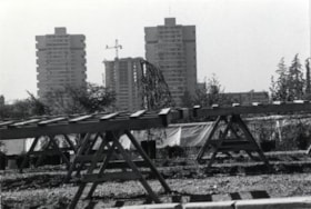
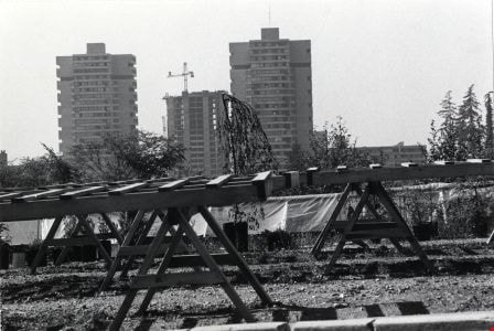
High-rise on Salish Court
https://search.heritageburnaby.ca/link/archivedescription79037
- Repository
- City of Burnaby Archives
- Date
- September 20, 1976
- Collection/Fonds
- Burnaby Public Library Contemporary Visual Archive Project
- Description Level
- Item
- Physical Description
- 1 photograph : b&w ; 11 x 16 cm mounted on cardboard
- Scope and Content
- Photograph shows a view of high-rise apartment buildings on Salish Court, looking west from the Blue Mountain Florist Shop on North Road.
- Repository
- City of Burnaby Archives
- Date
- September 20, 1976
- Collection/Fonds
- Burnaby Public Library Contemporary Visual Archive Project
- Physical Description
- 1 photograph : b&w ; 11 x 16 cm mounted on cardboard
- Description Level
- Item
- Record No.
- 556-106
- Access Restriction
- No restrictions
- Reproduction Restriction
- Reproduce for fair dealing purposes only
- Accession Number
- 2013-13
- Scope and Content
- Photograph shows a view of high-rise apartment buildings on Salish Court, looking west from the Blue Mountain Florist Shop on North Road.
- Media Type
- Photograph
- Photographer
- Campbell, Peg
- Notes
- Scope note taken directly from BPL photograph description.
- 1 b&w copy negative : 10 x 12.5 cm accompanying
- Geographic Access
- Salish Court
- Historic Neighbourhood
- Burquitlam (Historic Neighbourhood)
- Planning Study Area
- Cameron Area
Images
Century Park Museum Association fonds
https://search.heritageburnaby.ca/link/museumdescription3781
- Repository
- Burnaby Village Museum
- Date
- 1971-1989
- Collection/Fonds
- Century Park Museum Association fonds
- Description Level
- Fonds
- Physical Description
- 1814 photographs + 219 architectural drawings + 17 technical drawings + 4 videocassettes + 3 audio reels + 17 audio cassettes + 1.6 m of textual records + 2 maps
- Scope and Content
- Fonds consists of records created and collected by the Century Park Museum Association (renamed Burnaby Village Museum Association after 1984), which managed Heritage Village (later named Burnaby Village Museum) from its opening in 1971 until it's dissolution in December 1989. Records include archi…
- Repository
- Burnaby Village Museum
- Collection/Fonds
- Century Park Museum Association fonds
- Description Level
- Fonds
- Physical Description
- 1814 photographs + 219 architectural drawings + 17 technical drawings + 4 videocassettes + 3 audio reels + 17 audio cassettes + 1.6 m of textual records + 2 maps
- Scope and Content
- Fonds consists of records created and collected by the Century Park Museum Association (renamed Burnaby Village Museum Association after 1984), which managed Heritage Village (later named Burnaby Village Museum) from its opening in 1971 until it's dissolution in December 1989. Records include architectural drawings and proposals; photographs and films of the site; documentation of exhibits and artifacts, special events and programs; oral history interviews and other sound recordings; association meeting minutes; constitutions and bylaws; financial records; reports; correspondence; publications and research materials. Fonds has been arranged into the following series: 1) Century Park Museum Association photograph collection series 2) Century Park Museum Association film collection series 3) Century Park Museum Association architectural records and reports series 4) Heritage Village Museum oral history Interviews series 5) Heritage Village Museum presentations and Programming series 6) Century Park Museum Association reports series 7) Century Park Museum Association constitution, bylaws and agreements series 8) Century Park Museum Association minutes of meetings series 9) Century Park Museum association Board of Directors' administrative files series 10) Century Park Museum membership series 11) Heritage Village Museum exhibits and artifacts series 12) Century Park Museum Association committees' minutes and reports series 13) Museum staff adminstrative files series 14) Century Park Museum Association financial records series
- History
- The Heritage Village Museum was originally created as a British Columbia Centennial Project in 1971 through funding from the Federal, Provincial and Municipal governments. A sub-committee of the Burnaby Centennial '71 Committee was responsible for the creation of a permanent commemorative project. The concept for an open-air museum was developed with the location to be in Burnaby on lots 8,9, 10 and 11 of District Lot 79 and Lots 2 and 5, Block "R" of Districts Lots 79 and 85. The official sod turning for Heritage Village took place on April 11, 1971. In the spring of 1971, a museum director and curator were hired to oversee the development of the project and the acquisition of artifacts with funding from the Parks and Recreation Commission. The Century Park Museum Association (CPMA) was founded under the auspices of the Burnaby Centennial '71 Committee to govern Burnaby's Centennial '71 Commemorative Project, Heritage Village. The CPMA Board of directors were elected on October 26, 1971 with Donald (Don) Copan as the founding president (Don continued to serve on the Board until 1989). The Board of Directors reported directly to the Municipal Council. The association had an overall objective of providing a museum that was a historical resource for Burnaby and the region. The museum mandate was to collect, preserve, research, document and interpret artifacts and historical buildings that illustrated the history and lifestyle of the Lower Mainland in B.C. and Burnaby. The Museum focused on the period between 1890 and 1925 depicting a village lifestyle of a small community. This was achieved through the use of exhibits and displays within historic buildings and built reconstructions along with costumed museum interpreters. Many people contributed to the construction and design of the village. Architect, Rudy Kovach created the initial concept drawings and architecture designs were created by architectural design consultants Hopping, Kovach and Grinnell. Many carpenters and tradespeople worked on the construction of the buildings including Mr. Angelo Giacometti who was respsonible for much of the final decorative elements. The official opening of Heritage Village took place on November 19, 1971 with Burnaby Mayor Bob Prittie and Canada’s Governor General Roland Michener. Heritage Village was opened up to the public for a few days between November 19 and 21 with approximately 15,000 visitors. On July 1st, 1972 Heritage Village re-opened for the summer season with CPMA president, Don Copan and Mayor Bob Prittie officiating. This opening showcased further development of the site with more buildings and exhibits added. In 1984, Heritage Village Museum changed its name to “Burnaby Village Museum” and in turn, the Century Park Museum Association changed its name to the “Burnaby Village Museum Association”. Burnaby Village Museum continued to be governed by the Burnaby Village Museum Association until the end of 1989. In 1990, the Corporation of the District of Burnaby assumed the operation and management of Burnaby Village Museum under the Parks, Recreation and Cultural Services Department and the Burnaby Village Museum Association was dissolved.
- Responsibility
- Century Park Museum Association
- Accession Code
- BV985.6028
- BV005.14
- BV000.18
- BV011.44
- BV011.50
- BV014.30
- BV016.56
- BV017.46
- BV018.21
- BV019.52
- BV020.4
- BV020.5
- BV021.5
- BV022.9
- Date
- 1971-1989
- Media Type
- Photograph
- Sound Recording
- Textual Record
- Architectural Drawing
- Moving Images
- Cartographic Material
- Technical Drawing
- Related Material
- Donald Copan fonds
- Burnaby Centennial '71 Committee collection
- Royal Bank exhibit collection
- Bell's Dry Goods exhibit collection
- Jesse Love farmhouse fonds
- Burnaby Village Museum fonds
- Arrangement
- Records are arranged by types and functions of the Century Park Museum Association. The series reflects how they were maintained by the associaton, it's members and staff of Heritage Village (Burnaby Village Museum) while under the governance of the association.
- Notes
- Title based on contents of fonds
- Further accruals are expected
- Some records within this fonds are Closed - contact Burnaby Village Museum for access

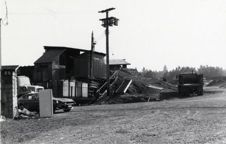
Meadowland Peat Limited
https://search.heritageburnaby.ca/link/archivedescription79358
- Repository
- City of Burnaby Archives
- Date
- September 23, 1976
- Collection/Fonds
- Burnaby Public Library Contemporary Visual Archive Project
- Description Level
- Item
- Physical Description
- 1 photograph : b&w ; 11 x 16 cm mounted on cardboard
- Scope and Content
- Photograph shows a construction site and building behind the sales office of Meadowland Peat Limited at 7625 Meadow Avenue. Meadowland Farms owned the site prior to 1974.
- Repository
- City of Burnaby Archives
- Date
- September 23, 1976
- Collection/Fonds
- Burnaby Public Library Contemporary Visual Archive Project
- Physical Description
- 1 photograph : b&w ; 11 x 16 cm mounted on cardboard
- Description Level
- Item
- Record No.
- 556-265
- Access Restriction
- No restrictions
- Reproduction Restriction
- Reproduce for fair dealing purposes only
- Accession Number
- 2013-13
- Scope and Content
- Photograph shows a construction site and building behind the sales office of Meadowland Peat Limited at 7625 Meadow Avenue. Meadowland Farms owned the site prior to 1974.
- Names
- Meadowland Peat Limited
- Media Type
- Photograph
- Photographer
- Campbell, Peg
- Notes
- Scope note taken directly from BPL photograph description.
- 1 b&w copy negative : 10 x 12.5 cm accompanying
- Geographic Access
- Meadow Avenue
- Street Address
- 7625 Meadow Avenue
- Historic Neighbourhood
- Fraser Arm (Historic Neighbourhood)
- Planning Study Area
- Big Bend Area
Images

Marine Food Basket
https://search.heritageburnaby.ca/link/archivedescription79097
- Repository
- City of Burnaby Archives
- Date
- November 14, 1976
- Collection/Fonds
- Burnaby Public Library Contemporary Visual Archive Project
- Description Level
- Item
- Physical Description
- 1 photograph : b&w ; 11 x 16 cm mounted on cardboard
- Scope and Content
- Photograph shows a large truck going past the Marine Food Basket at 5886 Marine Drive and the Hawaii Cafe next door. The buildings were constructed around 1930.
- Repository
- City of Burnaby Archives
- Date
- November 14, 1976
- Collection/Fonds
- Burnaby Public Library Contemporary Visual Archive Project
- Physical Description
- 1 photograph : b&w ; 11 x 16 cm mounted on cardboard
- Description Level
- Item
- Record No.
- 556-150
- Access Restriction
- No restrictions
- Reproduction Restriction
- Reproduce for fair dealing purposes only
- Accession Number
- 2013-13
- Scope and Content
- Photograph shows a large truck going past the Marine Food Basket at 5886 Marine Drive and the Hawaii Cafe next door. The buildings were constructed around 1930.
- Media Type
- Photograph
- Photographer
- Campbell, Peg
- Notes
- Scope note taken directly from BPL photograph description.
- 1 b&w copy negative : 10 x 12.5 cm accompanying
- Geographic Access
- Marine Drive
- Street Address
- 5886 Marine Drive
- Historic Neighbourhood
- Fraser Arm (Historic Neighbourhood)
- Planning Study Area
- Big Bend Area
Images
