
Construction Site near Salish Court
https://search.heritageburnaby.ca/link/archivedescription79039
- Repository
- City of Burnaby Archives
- Date
- September 27, 1976
- Collection/Fonds
- Burnaby Public Library Contemporary Visual Archive Project
- Description Level
- Item
- Physical Description
- 1 photograph : b&w ; 11 x 16 cm mounted on cardboard
- Scope and Content
- Photograph shows a view of a construction site taken from 9304 Salish Court Tower West.
- Repository
- City of Burnaby Archives
- Date
- September 27, 1976
- Collection/Fonds
- Burnaby Public Library Contemporary Visual Archive Project
- Physical Description
- 1 photograph : b&w ; 11 x 16 cm mounted on cardboard
- Description Level
- Item
- Record No.
- 556-107
- Access Restriction
- No restrictions
- Reproduction Restriction
- Reproduce for fair dealing purposes only
- Accession Number
- 2013-13
- Scope and Content
- Photograph shows a view of a construction site taken from 9304 Salish Court Tower West.
- Subjects
- Construction
- Media Type
- Photograph
- Photographer
- Campbell, Peg
- Notes
- Scope note taken directly from BPL photograph description.
- 1 b&w copy negative : 10 x 12.5 cm accompanying
- Geographic Access
- Salish Court
- Street Address
- 9304 Salish Court
- Historic Neighbourhood
- Burquitlam (Historic Neighbourhood)
- Planning Study Area
- Cameron Area
Images

Construction site on Still Creek Street
https://search.heritageburnaby.ca/link/archivedescription79007
- Repository
- City of Burnaby Archives
- Date
- October 23, 1976
- Collection/Fonds
- Burnaby Public Library Contemporary Visual Archive Project
- Description Level
- Item
- Physical Description
- 1 photograph : b&w ; 11 x 16 cm mounted on cardboard
- Scope and Content
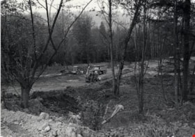
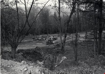
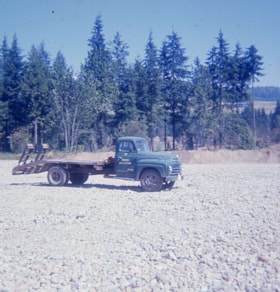
- Photograph shows trucks and earthmoving machinery at a construction site in the 9700 Block Still Creek Street.
- Repository
- City of Burnaby Archives
- Date
- October 23, 1976
- Collection/Fonds
- Burnaby Public Library Contemporary Visual Archive Project
- Physical Description
- 1 photograph : b&w ; 11 x 16 cm mounted on cardboard
- Description Level
- Item
- Record No.
- 556-087
- Access Restriction
- No restrictions
- Reproduction Restriction
- Reproduce for fair dealing purposes only
- Accession Number
- 2013-13
- Scope and Content
- Photograph shows trucks and earthmoving machinery at a construction site in the 9700 Block Still Creek Street.
- Subjects
- Construction
- Media Type
- Photograph
- Photographer
- Campbell, Peg
- Notes
- Scope note taken directly from BPL photograph description.
- 1 b&w copy negative : 10 x 12.5 cm accompanying
- Geographic Access
- Still Creek Avenue
Images

Quesnel Greene Construction
https://search.heritageburnaby.ca/link/archivedescription79014
- Repository
- City of Burnaby Archives
- Date
- October 23, 1976
- Collection/Fonds
- Burnaby Public Library Contemporary Visual Archive Project
- Description Level
- Item
- Physical Description
- 1 photograph : b&w ; 11 x 16 cm mounted on cardboard
- Scope and Content
- Photograph shows Quesnel Greene construction sign located at the corner of Aquarius Drive and Centaurus Circle. The Quesnel Green Co-operative Housing project was designed by Neinhaker/Irwin Associates and was built by Dunhill Development Corporation Ltd. It was owned by the Government of British…
- Repository
- City of Burnaby Archives
- Date
- October 23, 1976
- Collection/Fonds
- Burnaby Public Library Contemporary Visual Archive Project
- Physical Description
- 1 photograph : b&w ; 11 x 16 cm mounted on cardboard
- Description Level
- Item
- Record No.
- 556-091
- Access Restriction
- No restrictions
- Reproduction Restriction
- Reproduce for fair dealing purposes only
- Accession Number
- 2013-13
- Scope and Content
- Photograph shows Quesnel Greene construction sign located at the corner of Aquarius Drive and Centaurus Circle. The Quesnel Green Co-operative Housing project was designed by Neinhaker/Irwin Associates and was built by Dunhill Development Corporation Ltd. It was owned by the Government of British Columbia.
- Media Type
- Photograph
- Photographer
- Campbell, Peg
- Notes
- Scope note taken directly from BPL photograph description.
- 1 b&w copy negative : 10 x 12.5 cm accompanying
- Geographic Access
- Centaurus Circle
- Aquarius Drive
- Historic Neighbourhood
- Burquitlam (Historic Neighbourhood)
- Planning Study Area
- Lyndhurst Area
Images


Road Construction
https://search.heritageburnaby.ca/link/archivedescription79978
- Repository
- City of Burnaby Archives
- Date
- September 20, 1976
- Collection/Fonds
- Burnaby Public Library Contemporary Visual Archive Project
- Description Level
- Item
- Physical Description
- 1 photograph : b&w ; 11 x 16 cm mounted on cardboard
- Scope and Content
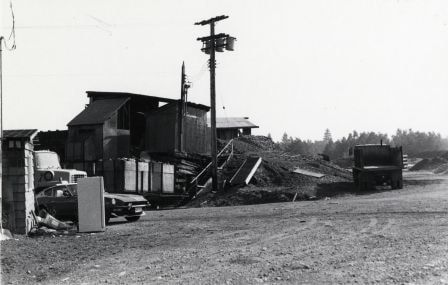
- Photograph shows view of road construction on Broadway behind the Lake City Industrial Park.
- Repository
- City of Burnaby Archives
- Date
- September 20, 1976
- Collection/Fonds
- Burnaby Public Library Contemporary Visual Archive Project
- Physical Description
- 1 photograph : b&w ; 11 x 16 cm mounted on cardboard
- Description Level
- Item
- Record No.
- 556-534
- Access Restriction
- No restrictions
- Reproduction Restriction
- Reproduce for fair dealing purposes only
- Accession Number
- 2013-13
- Scope and Content
- Photograph shows view of road construction on Broadway behind the Lake City Industrial Park.
- Media Type
- Photograph
- Photographer
- Campbell, Peg
- Notes
- Scope note taken directly from BPL photograph description.
- 1 b&w copy negative : 10 x 12.5 cm accompanying
- Geographic Access
- Broadway
- Planning Study Area
- Lake City Area
Images

High-rise on Salish Court
https://search.heritageburnaby.ca/link/archivedescription79037
- Repository
- City of Burnaby Archives
- Date
- September 20, 1976
- Collection/Fonds
- Burnaby Public Library Contemporary Visual Archive Project
- Description Level
- Item
- Physical Description
- 1 photograph : b&w ; 11 x 16 cm mounted on cardboard
- Scope and Content
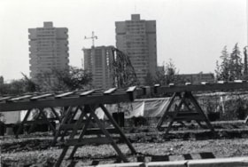
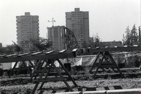
- Photograph shows a view of high-rise apartment buildings on Salish Court, looking west from the Blue Mountain Florist Shop on North Road.
- Repository
- City of Burnaby Archives
- Date
- September 20, 1976
- Collection/Fonds
- Burnaby Public Library Contemporary Visual Archive Project
- Physical Description
- 1 photograph : b&w ; 11 x 16 cm mounted on cardboard
- Description Level
- Item
- Record No.
- 556-106
- Access Restriction
- No restrictions
- Reproduction Restriction
- Reproduce for fair dealing purposes only
- Accession Number
- 2013-13
- Scope and Content
- Photograph shows a view of high-rise apartment buildings on Salish Court, looking west from the Blue Mountain Florist Shop on North Road.
- Media Type
- Photograph
- Photographer
- Campbell, Peg
- Notes
- Scope note taken directly from BPL photograph description.
- 1 b&w copy negative : 10 x 12.5 cm accompanying
- Geographic Access
- Salish Court
- Historic Neighbourhood
- Burquitlam (Historic Neighbourhood)
- Planning Study Area
- Cameron Area
Images
Burnaby Mountain Golf Course photographs
https://search.heritageburnaby.ca/link/archivedescription66715
- Repository
- City of Burnaby Archives
- Date
- 1965-1970
- Collection/Fonds
- Robert Bailey fonds
- Description Level
- File
- Physical Description
- 39 photographs : col. slides ; 35 mm
- Scope and Content
- Photographs of the construction and opening of the Burnaby Mountain Golf Course, taken by Robert Bailey.
- Repository
- City of Burnaby Archives
- Date
- 1965-1970
- Collection/Fonds
- Robert Bailey fonds
- Physical Description
- 39 photographs : col. slides ; 35 mm
- Description Level
- File
- Record No.
- 526-001
- Access Restriction
- No restrictions
- Reproduction Restriction
- No restrictions
- Accession Number
- 2011-14
- Scope and Content
- Photographs of the construction and opening of the Burnaby Mountain Golf Course, taken by Robert Bailey.
- Subjects
- Recreational Activities - Golf
- Names
- Bailey, Robert
- Media Type
- Photograph
- Photographer
- Bailey, Robert
- Notes
- Title based on contents of file
- Note on verso of 526-001-4 reads: "Burnaby clearing"
- Note on verso of 526-001-14 reads: "Ravine Burnaby"
- Note on verso of 526-001-17 reads: "Burnaby GClub / Apr 26 68"
- Note on verso of 526-001-29 reads: "#8 Tee Burnaby / Apr 26 68"
- Date on stamp on verso of 526-001-30 reads: "Mar 69V3"
- Note on recto of 526-001-30 reads: "Burnaby in Fall #7"
- Note on verso of 526-001-31 reads: "Burnaby Lake & Clubhouse / April [?] / 68"
- Note on verso of 526-001-32 reads: "Burnaby Const[?] / Bob Bailey - Emilio"
- Date stamp on verso of 526-001-33:526-001-39 reads: "May 69V2"
- Geographic Access
- Burnaby Mountain Conservation Area
Images


Meadowland Peat Limited
https://search.heritageburnaby.ca/link/archivedescription79358
- Repository
- City of Burnaby Archives
- Date
- September 23, 1976
- Collection/Fonds
- Burnaby Public Library Contemporary Visual Archive Project
- Description Level
- Item
- Physical Description
- 1 photograph : b&w ; 11 x 16 cm mounted on cardboard
- Scope and Content
- Photograph shows a construction site and building behind the sales office of Meadowland Peat Limited at 7625 Meadow Avenue. Meadowland Farms owned the site prior to 1974.
- Repository
- City of Burnaby Archives
- Date
- September 23, 1976
- Collection/Fonds
- Burnaby Public Library Contemporary Visual Archive Project
- Physical Description
- 1 photograph : b&w ; 11 x 16 cm mounted on cardboard
- Description Level
- Item
- Record No.
- 556-265
- Access Restriction
- No restrictions
- Reproduction Restriction
- Reproduce for fair dealing purposes only
- Accession Number
- 2013-13
- Scope and Content
- Photograph shows a construction site and building behind the sales office of Meadowland Peat Limited at 7625 Meadow Avenue. Meadowland Farms owned the site prior to 1974.
- Names
- Meadowland Peat Limited
- Media Type
- Photograph
- Photographer
- Campbell, Peg
- Notes
- Scope note taken directly from BPL photograph description.
- 1 b&w copy negative : 10 x 12.5 cm accompanying
- Geographic Access
- Meadow Avenue
- Street Address
- 7625 Meadow Avenue
- Historic Neighbourhood
- Fraser Arm (Historic Neighbourhood)
- Planning Study Area
- Big Bend Area
Images
Robert Bailey fonds
https://search.heritageburnaby.ca/link/archivedescription66714
- Repository
- City of Burnaby Archives
- Date
- 1965-1970
- Collection/Fonds
- Robert Bailey fonds
- Description Level
- Fonds
- Physical Description
- 39 photographs : col. slides ; 35 mm
- Scope and Content
- Fonds consists of photographs of the construction and opening of the Burnaby Mountain Golf Course, taken by Robert Bailey.
- Repository
- City of Burnaby Archives
- Date
- 1965-1970
- Collection/Fonds
- Robert Bailey fonds
- Physical Description
- 39 photographs : col. slides ; 35 mm
- Description Level
- Fonds
- Access Restriction
- No restrictions
- Accession Number
- 2011-14
- Scope and Content
- Fonds consists of photographs of the construction and opening of the Burnaby Mountain Golf Course, taken by Robert Bailey.
- History
- Robert Bailey worked as the Parks Superintendent in Burnaby until 1975. He died in 2002.
- Media Type
- Photograph
- Creator
- Bailey, Robert
- Notes
- Title based on contents of fonds
- Photo catalogue 526

Marine Food Basket
https://search.heritageburnaby.ca/link/archivedescription79097
- Repository
- City of Burnaby Archives
- Date
- November 14, 1976
- Collection/Fonds
- Burnaby Public Library Contemporary Visual Archive Project
- Description Level
- Item
- Physical Description
- 1 photograph : b&w ; 11 x 16 cm mounted on cardboard
- Scope and Content
- Photograph shows a large truck going past the Marine Food Basket at 5886 Marine Drive and the Hawaii Cafe next door. The buildings were constructed around 1930.
- Repository
- City of Burnaby Archives
- Date
- November 14, 1976
- Collection/Fonds
- Burnaby Public Library Contemporary Visual Archive Project
- Physical Description
- 1 photograph : b&w ; 11 x 16 cm mounted on cardboard
- Description Level
- Item
- Record No.
- 556-150
- Access Restriction
- No restrictions
- Reproduction Restriction
- Reproduce for fair dealing purposes only
- Accession Number
- 2013-13
- Scope and Content
- Photograph shows a large truck going past the Marine Food Basket at 5886 Marine Drive and the Hawaii Cafe next door. The buildings were constructed around 1930.
- Media Type
- Photograph
- Photographer
- Campbell, Peg
- Notes
- Scope note taken directly from BPL photograph description.
- 1 b&w copy negative : 10 x 12.5 cm accompanying
- Geographic Access
- Marine Drive
- Street Address
- 5886 Marine Drive
- Historic Neighbourhood
- Fraser Arm (Historic Neighbourhood)
- Planning Study Area
- Big Bend Area
Images
