Narrow Results By
Subject
- Aerial Photographs 3
- Buildings - Civic - City Halls 10
- Buildings - Commercial - Stores 2
- Buildings - Religious - Churches 1
- Buildings - Residential 2
- Buildings - Residential - Cabins 1
- Buildings - Residential - Houses 27
- Buildings - Schools 6
- Ceremonies - Graduations 1
- Construction 42
- Construction - Road Construction 5
- Construction Tools and Equipment 5
Paneloc Marketing Ltd. business records series
https://search.heritageburnaby.ca/link/museumdescription15112
- Repository
- Burnaby Village Museum
- Date
- 1957-1973
- Collection/Fonds
- Elmer Wilson Martin fonds
- Description Level
- Series
- Physical Description
- 10 photographs + 9 architectural drawings + approx. 2 cm of textual records
- Scope and Content
- Series consists of business records relating to Elmer Wilson Martin's involvement with Paneloc Marketing Ltd. including business cards; architectural drawings of various building models; correspondence; reports; price lists; quotes and photographs of completed paneloc buildings and buildings under …
- Repository
- Burnaby Village Museum
- Collection/Fonds
- Elmer Wilson Martin fonds
- Description Level
- Series
- Physical Description
- 10 photographs + 9 architectural drawings + approx. 2 cm of textual records
- Scope and Content
- Series consists of business records relating to Elmer Wilson Martin's involvement with Paneloc Marketing Ltd. including business cards; architectural drawings of various building models; correspondence; reports; price lists; quotes and photographs of completed paneloc buildings and buildings under construction. Series also includes an Elections poster when E.W. Martin ran for Reeve of Burnaby in 1959.
- Accession Code
- BV019.37; BV019.40
- Date
- 1957-1973
- Media Type
- Photograph
- Textual Record
- Architectural Drawing
- Notes
- Title based on contents of series
Patterson family subseries
https://search.heritageburnaby.ca/link/archivedescription32
- Repository
- City of Burnaby Archives
- Date
- 1898-1952
- Collection/Fonds
- Burnaby Historical Society fonds
- Description Level
- Subseries
- Physical Description
- Textual records and photographs
- Scope and Content
- Subseries consists of documents and photographs pertaining to the Patterson family.
- Repository
- City of Burnaby Archives
- Date
- 1898-1952
- Collection/Fonds
- Burnaby Historical Society fonds
- Subseries
- Patterson family subseries
- Physical Description
- Textual records and photographs
- Description Level
- Subseries
- Accession Number
- BHS1986-19
- BHS1986-20
- BHS1988-13
- BHS1995-16
- BHS1996-05
- BHS1996-11
- Scope and Content
- Subseries consists of documents and photographs pertaining to the Patterson family.
- History
- Frances Mabel "May" Webb was born in Cradley, England on December 5, 1872. She sailed from England to Victoria, BC with her parents, Joseph William Webb and Frances Jane Webb (nee Yapp) on the SS Lake Winnipeg in 1889. One of the few possessions that she brought with her was an old wood-rimmed bicycle which she found quite useful after her move to Burnaby. She would ride it all the way from Patterson’s Trail and Westminster Road (today’s Patterson Avenue and Kingsway) to the Woodward’s store in Vancouver where she would place her grocery order. She packed a pearl handled revolver with her in order to scare any bears she might see along her ride. In 1890, Frances married Dugald Campbell Patterson (b. 1860, d. 1931) in Victoria, BC. In 1894, the couple built a pioneer homestead and farm on five acres at what would become the north east section of Central Park. Dugald founded Vulcan Iron Works (later Dominion Bridge Company) in New Westminister in 1903, and the couple settled in the Central Park district. By 1904, the family moved to the Edmonds district where in 1909 she operated the post office that her husband founded. In 1910, they began construction of a new house, complete with tennis courts and a gazebo, on 14 acres purchased for $720. The house is now located at 7106 18th Avenue and is a dedicated heritage building. The couple had seven children: William H. "Bill", Jean, Frances Mabel Lili., Dugald C. Jr, Mary, Charles Bruce, and Alice. The Pattersons were community-minded citizens that served Burnaby through their involvement with local municipal affairs and politics. In 1909, Dugald became the first postmaster of Edmonds. He also served as a School Trustee from 1912-13 and was one of the first residents to lobby Burnaby City Council to preserve the local ravines as parks. They also helped build the Central Park Presbyterian Church, along with other pioneer families. The family name is remembered and honoured by the naming of Patterson Avenue and the Patterson SkyTrain Station located in the Metrotown area. Frances Mabel assisted her husband with an insurance and real estate company that he founded in Burnaby and New Westminster. This experience would prove invaluable, as she would later become an insurance agent for the Wawanesa Insurance Company (founded in 1896). Frances never owned an automobile, so she met her insurance clients all over Burnaby, New Westminster and Vancouver by using the Lower Mainland’s street car system. The insurance profession continued to provide her with a steady income long after her husband’s death. Frances Mabel died in New Westminster, BC on August 30, 1960. Frances Mabel Lili Patterson was born on June 9, 1905 and was the fifth child born to Dugald Campbell and Frances Mabel Patterson. She became the first PBX switchboard operator for the Municipality of Burnaby in the early 1920’s. PBX, or Private Branch Exchange, was the term used for an internal telephone system. Frances later became president of the Professional Women’s Association of New Westminster, and volunteered her time with the May Day celebrations in New Westminster. She was also a dedicated member of the Rebekah Lodge (the women’s division of the Independent Order of Odd Fellows). While in the lodge, she met her future husband, Walter Duke and they married on July 12, 1939. They couple moved to Wenatchee, Washington after getting married, and Frances relocated to Victoria after her husband died. Frances died on January 13, 1974. Doreen Nettie Patterson was born December 12, 1927, the youngest daughter of Charles Bruce Patterson and Elva Eleanore Patterson (nee Elliott). At age 23, Doreen became the first woman from BC to enlist in the new Women’s Royal Canadian Naval Service and by the fall of 1951, she had become a Wren in the Royal Canadian Navy. She received her basic training at HMCS Cornwallis and became a radio intelligence operator for the wireless communications base at Naval Radio Station Coverdale near Moncton, New Brunswick. In 1953, she was chosen to serve a term at the naval base in Churchill, Manitoba. She was one of only eleven women to ever serve there. After her career in the navy, Doreen worked in the accounting division for Simpsons-Sears in Burnaby near her grandparent’s original family home at Patterson Avenue and Kingsway. Doreen married Gerard Reitsma on August 18, 1960. Doreen died on April 30, 2000.
- Media Type
- Textual Record
- Photograph
- Notes
- Title based on contents of subseries
- PC171, PC213, PC322, PC326, MSS024, MSS039
Plan filing room. Fire hazard???
https://search.heritageburnaby.ca/link/archivedescription36570
- Repository
- City of Burnaby Archives
- Date
- 1952
- Collection/Fonds
- Burnaby Historical Society fonds
- Description Level
- Item
- Physical Description
- 1 photograph : b&w ; 17.5 x 12.5 cm print
- Scope and Content
- Photograph of the "PLAN FILING ROOM [believed to be a] FIRE HAZZARD [sic]???" inside the second Burnaby Municipal Hall.
- Repository
- City of Burnaby Archives
- Date
- 1952
- Collection/Fonds
- Burnaby Historical Society fonds
- Subseries
- Archie Miller subseries
- Physical Description
- 1 photograph : b&w ; 17.5 x 12.5 cm print
- Description Level
- Item
- Record No.
- 296-013
- Access Restriction
- No restrictions
- Reproduction Restriction
- Reproduce for fair dealing purposes only
- Accession Number
- BHS1992-36
- Scope and Content
- Photograph of the "PLAN FILING ROOM [believed to be a] FIRE HAZZARD [sic]???" inside the second Burnaby Municipal Hall.
- Names
- Burnaby City Hall
- Media Type
- Photograph
- Photographer
- Dibble, Bob
- Notes
- Title taken from caption given to photograph in original pamphlet
- Photographs copies of originals used in "UNITE BURNABY" pamphlet which asked citizens to "VOTE YES" to the construction of a new Municipal Hall in Burnaby
- Geographic Access
- Kingsway
- Street Address
- 7282 Kingsway
- Historic Neighbourhood
- Edmonds (Historic Neighbourhood)
- Planning Study Area
- Stride Avenue Area
Images

Planning Department fonds
https://search.heritageburnaby.ca/link/archivedescription102
- Repository
- City of Burnaby Archives
- Date
- 1940-2016
- Collection/Fonds
- Planning Department fonds
- Description Level
- Fonds
- Physical Description
- 80 m of textual records and other material
- Scope and Content
- Fonds consists of those records created during the regular conduct of business by the Planning Department and its predecessor agencies according to their mandate of providing professional and technical advice to Council on the current and future uses of City land and resources.
- Repository
- City of Burnaby Archives
- Date
- 1940-2016
- Collection/Fonds
- Planning Department fonds
- Physical Description
- 80 m of textual records and other material
- Description Level
- Fonds
- File Class
- 71000 10 (add. 2020)
- 71000 20 (add. 2020)
- 71000 30 (add. 2020)
- 71000 40 (add. 2020)
- Access Restriction
- Subject to FOIPPA
- Reproduction Restriction
- Reproductions subject to FOIPPA.
- Scope and Content
- Fonds consists of those records created during the regular conduct of business by the Planning Department and its predecessor agencies according to their mandate of providing professional and technical advice to Council on the current and future uses of City land and resources.
- History
- The City of Burnaby Planning Department was established on October 9, 1956, when the City Council unanimously carried the motion to create a distinct department to deal with planning issues within the City and appointed Mr. William John Blakely as its head. This decision followed a report and recommendation made by the City’s Chief Administrative Officer which indicated that the role of the Planning Engineer and his staff had quickly expanded to become a separate division within the Engineering Department and that they were functioning as an independent unit in all but name. The proposed separation of the Engineering and Planning departments had been in the works since the early part of 1956 when staff changes and restructuring within the Engineering Department’s Planning Division illustrated the undermanned condition of the Planning Engineer’s office. As a result, Council asked the Chief Administrative Officer to undertake a study examining the feasibility of creating a distinct Planning Department. This report was delivered to Council on July 3, 1956, but was laid over until a Committee of the Council had the opportunity to study the functions of the Planning department to determine the necessity of the proposal. The Committee’s findings were in line with the initial report and the Planning Department was established with a staff of nine (the head Planning Engineer, an Administrative Planner, three Research Planning Assistants, a Draughtsman, a Subdivision Control Clerk, a department Clerk and a Clerk Stenographer). This new department was to offer advice and carry out the work intensive in matters such as zoning and rezoning applications, subdivision control, traffic and transportation planning, and general City planning schemes. Prior to the creation of the Planning Department, a number of bodies within the City had been responsible for fulfilling the functions carried out by this new unit. In the earliest years of the City, the members of Council were responsible for matters of planning and were assisted in their job by the City’s Engineer or any number of hired consultants (e.g. surveyors, cartographers). By 1906, however, the provincial laws surrounding the subdivision process had changed, and local governments were charged with the task of approving all private subdivision plans in their respective Municipalities. In Burnaby, the City Council passed a bylaw decreeing that all subdivision plans were to be submitted to Council for review and the City Engineer was responsible for ensuring compliance with the law. After the first Town Planning Bylaw in 1924 which restricted the type and size of construction that could occur in certain City areas, the Engineering and Building departments were to work together to oversee the enforcement of the Bylaw and the development of City plans. The scope and competence required to carry out this work grew as Burnaby’s population expanded, and in 1930 Council passed the Town Planning Commission Bylaw (No. 1028) that saw the creation of a permanent body – the Town Planning Commission – which was to serve as an advisory body to help direct the planning activities in the City while the actual work continued to be carried out by the Engineering Department. This body was comprised of the Reeve, the Chairman of the School Board, the Chairman of the Park Committee (later, the Board of Parks Commissioners), and six appointed citizens who served three-year terms. Council referred all matters of subdivisions, transportation planning, and rezoning to this Commission, which was later supported in its work by several other special or standing committees such as the Subdivision Committee, the Apartment Committee, the Transportation Committee or the Town Planning Board of Appeal. By 1953, it had become apparent that the advisory committees that were dedicated to these planning issues needed a permanent staff to carry out the work intensive, so a restructuring of the Engineering department resulted in a permanent Planning Engineer’s office being created. The Town Planning Commission continued in its advisory capacity even after the determination came in 1956 to create a separate Planning Department. When Bylaw No. 4473 was passed in 1963, the Town Planning Commission was disbanded in favour of a new Advisory Planning Commission that would turn over all routine matters such as subdivision and rezoning applications to the Planning Department but would offer advice and community input into the more complex planning schemes within the City and act as an intermediary in cases where Council and Planning staff were in disagreement. A new Advisory Planning Commission Bylaw (No. 7600) was adopted in 1980 which allowed for even greater community participation in the planning process. The Planning Department was initially responsible to report directly to Council, but in 1957, the administrative structure of Municipal staff changed with the introduction of the Burnaby Municipal Manager Bylaw (No. 3859) and from that point on, the head of the Planning Department held a direct reporting relationship to the Municipal Manager, who in turn was responsible for reporting the activities of the Department to the City Council. Over the years, the internal structure and the scope of responsibilities of the Department have changed during periods of staff reorganizations. Under the larger umbrella of the Planning and Building Department, Planning has come to be comprised of two divisions: the Current Planning Division and the Long Range Planning Division. The functions of the Current Planning Division include rezoning, subdivision, development plan areas, preliminary plan approvals, urban design, heritage planning, and urban trails and bicycle routes. The Long Range Planning Division is responsible for environmental planning concerns, transportation planning, housing, neighbourhood area planning, social planning and planning information services. In 2022, the Planning and Building Department was reorganized to better align functions with delivery of services. The Climate Action and Engery Division moved from Corporate Services to the Planning and Building Department, while Indigenous Relations and Facilities Management moved to Corporate Services and Lands and Facilities, respectively. The position of Director of Planning and Building was changed to General Manager, Planning and Development. The following individuals have served as Planning Engineer and/or Director of the Planning Department and/or General Manager, Planning and Development for the City of Burnaby: William John Blakely 1954-1956 (as Planning Engineer) 1956-1963 (as Head of the Department) Anthony P. Parr 1964-1993 Don G. Stenson 1993-2001 Jack S. Belhouse 2001-2006 Basil Luksun 2006-2012 Lou Pelletier 2012-2019 Edward Kozak 2019-present
- Formats
- Microforms exist for some records. See series descriptions.
- Media Type
- Textual Record
- Photograph
- Moving Images
- Creator
- City of Burnaby
- Notes
- Title based on contents of fonds
Riverway West School PTA scrapbook
https://search.heritageburnaby.ca/link/archivedescription58351
- Repository
- City of Burnaby Archives
- Date
- 1923-1967
- Collection/Fonds
- Burnaby Historical Society fonds
- Description Level
- Item
- Physical Description
- 1 scrapbook
- Scope and Content
- Item is a scrapbook created by the Riverway West School Parent-Teachers' Association. Included in the scrapbook are photographs, correspondence, reports and newspaper clippings. Documents and photos within are related to Burnaby's first May Days including the first programme and May Queen photograp…
- Repository
- City of Burnaby Archives
- Date
- 1923-1967
- Collection/Fonds
- Burnaby Historical Society fonds
- Physical Description
- 1 scrapbook
- Material Details
- Scrapbook is a binder made of wood with construction paper pages housed inside plastic sheets
- Description Level
- Item
- Record No.
- MSS068-001
- Access Restriction
- No restrictions
- Reproduction Restriction
- No known restrictions
- Accession Number
- BHS1992-03
- Scope and Content
- Item is a scrapbook created by the Riverway West School Parent-Teachers' Association. Included in the scrapbook are photographs, correspondence, reports and newspaper clippings. Documents and photos within are related to Burnaby's first May Days including the first programme and May Queen photograph, the formation of the Riverway Park, PTA functions, members, Riverway West student photographs. The scrapbook was created by the 1960-1961 PTA members, notably: Mrs. Emily Eichler, Historian; Mrs. C.L. James, Assistant Historian; Mrs. Gordon Dowding, Photographer; and Mr. Rod Beaton, who designed the cover. The design on the wooden cover of the scrapbook was burned into the wood by Mrs. Eichler's son using a magnifying glass. The last page was added in 1967 or later.
- Media Type
- Textual Record
- Photograph
Simpsons-Sears Limited Burnaby fonds
https://search.heritageburnaby.ca/link/museumdescription17413
- Repository
- Burnaby Village Museum
- Date
- 1954-1959, predominant 1954-1955
- Collection/Fonds
- Simpsons-Sears Limited Burnaby fonds
- Description Level
- Fonds
- Physical Description
- 114 photographs + 15 cm of textual records
- Scope and Content
- Fonds consists of photographs and textual records from a scrapbook documenting the early years of the Simpsons-Sears store located at 3660 Kingsway (after 1959 - 4750 Kingsway) in Burnaby including the opening day and staff events. Many of the photographs depict, Manager of Simpsons-Sears, Burnaby,…
- Repository
- Burnaby Village Museum
- Collection/Fonds
- Simpsons-Sears Limited Burnaby fonds
- Description Level
- Fonds
- Physical Description
- 114 photographs + 15 cm of textual records
- Scope and Content
- Fonds consists of photographs and textual records from a scrapbook documenting the early years of the Simpsons-Sears store located at 3660 Kingsway (after 1959 - 4750 Kingsway) in Burnaby including the opening day and staff events. Many of the photographs depict, Manager of Simpsons-Sears, Burnaby, T. Boyd Haskell and include photographs regarding activities of the Greater Vancouver Tourist Association in which T. Boyd Haskell was president 1958-1959. Textual records within fonds include a financial ledger (1954-1956) as well as congratulatory telegrams and cards addressed to Simpsons-Sears staff and managers regarding the Simpsons-Sears store opening in May 1954 along with lists of names of Simpsons-Sears and Sears-Roebuck executive members who visited the store. Records are arranged into the following series: 1) Simpsons-Sears scrapbook series 2) Burnaby Simpsons-Sears adminstrative records series
- History
- In 1952, U.S. Chairman of Sears-Roebuck and Company, General Robert E.Wood, contacted President of Robert Simpson Company, Edgar G. Burton proposing a partnership between the two companies to serve the Canadian retail market. In September 1952, a merger was signed between the two to create Simpsons-Sears Limited. The terms of the agreement were 50-50. The two main objectives were to expand the Simpsons’ mail order business which was sold to the new company and to build new retail stores across Canada that were modelled on the Sears, Roebuck’s design. In early 1953, operations began with the first Simpsons-Sears Spring/Summer catalogue that was delivered to 300,00 homes across Canada. In September 1953, the first Simpsons-Sears retail store opened in Stratford Ontario and in December 1953 the second store opened in Kamloops, B.C. In 1953, with a 7.6 million dollar investment, construction began on the Simpsons-Sears store located at 3660 Kingsway in Burnaby. This was the second Simpsons-Sears store to be built in British Columbia. The store was designed by two Vancouver architectural firms Sharp, Thompson, Berwick and Pratt and Gardiner and Thornton. The new Burnaby Simpsons-Sears was touted as the most modern mall in Canada with the facing of the store consisting of Travertine marble imported from Italy and the main floor included fourty eight miles of brass strips incorporated in the terrazzo floor which was made from marble chips mixed with white Portland concrete. An exterior promenade, built from British Columbia fir and bolted with copper and brass was built around the exterior of the store. The promenade provided an outdoor display area for garden furniture and other large items. The retail store officially opened on May 5, 1954 with Simpsons-Sears executive members, managers and the Reeve of Burnaby in attendance. T. Boyd Haskell, from Spokane, Washington was hired as the Burnaby retail store manager and C.W. Jaggs, former Simpsons' general manager for British Columbia became manager of the Simpsons-Sears mail order business in British Columbia. A ribbon cutting ceremony took place during the opening event with Burnaby Reeve Charles W. MacSorley in attendance along with other dignitaries from Simpsons-Sears including President of Simpsons-Sears, E.G. Burton; Chairman of the board of Simpsons-Sears, Charles W. Burton; Vice President of Simpsons-Sears, G.F. Trotter; Mail Order Manager for Simpsons-Sears, B.C., C.W. Jaggs and Manager of Simpsons-Sears, Burnaby, T. Boyd Haskell. Over 10,000 people attended the opening of the store at 11:00 a.m. and it is believed that throughout the day, over 75,000 people went through the new store. T. Boyd Haskell was manager of the Burnaby Simpsons-Sears store between 1953 and 1962. After graduating from college, Haskell joined the Sears-Roebuck department store chain. In 1953 he moved to Vancouver from Washington State to set up the new store in Burnaby. In 1962, Haskell left Simpsons-Sears in Burnaby and transferred to the Sears store in Los Angeles. During his time in British Columbia, Haskell served as the President of the Greater Vancouver Tourist Association (1958-1959), President of the Community Chest and Councils of Greater Vancouver (1960) and was also a member of the board of directors of the B.C. Lions football team. Haskell died in Arizona in 1969 at the age of 54 years. In 1978, the Hudson’s Bay Company purchased “Simpsons” and converted many of the department stores into The Bay, including the store in downtown Toronto. Sears stores continued to carry the name “Simpsons-Sears” until 1984 when the named changed to “Sears Canada”. The Simpsons-Sears store (later named "Sears") located at 4750 Kingsway (Metropolis at Metrotown) closed it's doors in 2018.
- Creator
- Simpsons-Sears Limited
- Accession Code
- BV021.26
- BV022.17
- Date
- 1954-1959, predominant 1954-1955
- Media Type
- Photograph
- Textual Record
- Related Material
- See also: memorial program for T.B. Haskell in Burnaby Village Museum artifact collection BV021.26.166
- Arrangement
- Arrangement of records is based on original order of scrapbook and financial ledger by creator(s). Photographs and textual records were described in the order that they were arranged within original scrapbook prior to being removed.
- Notes
- Title based on contents of fonds
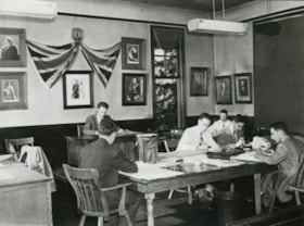
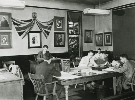
Staff using Council Chamber
https://search.heritageburnaby.ca/link/archivedescription36564
- Repository
- City of Burnaby Archives
- Date
- 1952
- Collection/Fonds
- Burnaby Historical Society fonds
- Description Level
- Item
- Physical Description
- 1 photograph : b&w ; 12.5 x 17.5 cm print
- Scope and Content
- Photograph of "STAFF USING COUNCIL CHAMBER" at the second Burnaby Municipal Hall.
- Repository
- City of Burnaby Archives
- Date
- 1952
- Collection/Fonds
- Burnaby Historical Society fonds
- Subseries
- Archie Miller subseries
- Physical Description
- 1 photograph : b&w ; 12.5 x 17.5 cm print
- Description Level
- Item
- Record No.
- 296-007
- Access Restriction
- No restrictions
- Reproduction Restriction
- Reproduce for fair dealing purposes only
- Accession Number
- BHS1992-36
- Scope and Content
- Photograph of "STAFF USING COUNCIL CHAMBER" at the second Burnaby Municipal Hall.
- Names
- Burnaby City Hall
- Media Type
- Photograph
- Photographer
- Dibble, Bob
- Notes
- Title taken from caption given to photograph in original pamphlet
- Photographs copies of originals used in "UNITE BURNABY" pamphlet which asked citizens to "VOTE YES" to the construction of a new Municipal Hall in Burnaby
- Geographic Access
- Kingsway
- Street Address
- 7282 Kingsway
- Historic Neighbourhood
- Edmonds (Historic Neighbourhood)
- Planning Study Area
- Stride Avenue Area
Images
![Unidentifed man holding a golf club, [between 1940 and 1960] thumbnail](/media/hpo/_Data/_Archives_Images/_Unrestricted/550/550-256.jpg?width=280)
Unidentifed man holding a golf club
https://search.heritageburnaby.ca/link/archivedescription82729
- Repository
- City of Burnaby Archives
- Date
- [between 1940 and 1960]
- Collection/Fonds
- Hill family and Vidal family fonds
- Description Level
- Item
- Physical Description
- 1 photograph : sepia, mounted on construction paper ; 14 x 8.5 cm
- Scope and Content
- Photograph is a portrait of an unidentified man leaning on a golf club.
- Repository
- City of Burnaby Archives
- Date
- [between 1940 and 1960]
- Collection/Fonds
- Hill family and Vidal family fonds
- Physical Description
- 1 photograph : sepia, mounted on construction paper ; 14 x 8.5 cm
- Description Level
- Item
- Record No.
- 550-256
- Access Restriction
- No restrictions
- Reproduction Restriction
- No restrictions
- Accession Number
- 2013-03
- Scope and Content
- Photograph is a portrait of an unidentified man leaning on a golf club.
- Subjects
- Recreational Activities - Golf
- Media Type
- Photograph
- Notes
- Title based on contents of photograph
Images
![Unidentifed man holding a golf club, [between 1940 and 1960] thumbnail](/media/hpo/_Data/_Archives_Images/_Unrestricted/550/550-256.jpg)
Walker family fonds
https://search.heritageburnaby.ca/link/archivedescription78708
- Repository
- City of Burnaby Archives
- Date
- 1948-1957 (date of originals); 2013
- Collection/Fonds
- Walker family fonds
- Description Level
- Fonds
- Physical Description
- 38 photographs (7 jpeg : col., 300 dpi ; 7 jpeg : col., 96 dpi ; 10 jpeg : b&w, 300 dpi ; 12 jpeg : b&w, 96 dpi). 1 drawing (jpeg) : col., 300 dpi ; 2 maps (jpeg) : col. ; 96 dpi ; 397.67 KB of textual records.
- Scope and Content
- Fonds consists of 41 jpegs of original photographs (some include annotation), maps, and newspaper clippings pertaining to Scotty Walker, his family and the Inter-City Driving Range that he created.
- Repository
- City of Burnaby Archives
- Date
- 1948-1957 (date of originals); 2013
- Collection/Fonds
- Walker family fonds
- Physical Description
- 38 photographs (7 jpeg : col., 300 dpi ; 7 jpeg : col., 96 dpi ; 10 jpeg : b&w, 300 dpi ; 12 jpeg : b&w, 96 dpi). 1 drawing (jpeg) : col., 300 dpi ; 2 maps (jpeg) : col. ; 96 dpi ; 397.67 KB of textual records.
- Description Level
- Fonds
- Access Restriction
- No restrictions
- Reproduction Restriction
- May be restricted by third party rights
- Accession Number
- 2013-15
- Scope and Content
- Fonds consists of 41 jpegs of original photographs (some include annotation), maps, and newspaper clippings pertaining to Scotty Walker, his family and the Inter-City Driving Range that he created.
- History
- Scotty Walker purchased the property at 974 12th Avenue in 1948 under the Veteran’s Land Act (VLA) grant from the government. He was in the Air Force during the Second World War. Previous to the purchase he ran a trucking business in New Westminster and lived at 1421 Nanaimo Street. The family consisted of Scotty, his wife Elizabeth, and three children, Alex, Barbara, and James. The land was overgrown with trees, scrub bushes, and a general swampy area. Scotty had the plan to build a Golf Driving Range, but it would take a lot of work. He owned three acres and leased three acres from the Lady of Mercy Church. Then they started working the land. The trees and scrub bush had to be removed and it was all done by hand. As the weather warmed and the swamp dried somewhat, Scotty got the idea to do selective burning. After many times doing this in small sections, the wind changed and the fire was headed for some houses on Tenth Avenue. The fire departments from New Westminster and Burnaby showed up and he was severely punished. It created other problems too. The land was swampy and when it dried, it was a peat bog, so the fire would burn down and turn up all over the place. That winter when the rains came, the land flooded and froze. The kids in the neighbourhood took advantage of the open spaces and brought out their skates. They had a great time. Some pigs were purchased with the idea that they could help dig up the roots and could be butchered later. Well they cleared the roots, but the kids all said they would not eat the pigs. The pigs were sold as they had become like pets. The land was then bulldozed into a berm on the 12th Street side of the land and a fence was built on top of the hill. The Walkers still had to clear the roots and branches that accumulated on the berm. The big problem was snakes. There were pits of water snakes that had been moved with the bulldozing. The family is not sure what happened with the snakes but eventually they moved. The area that would have been to the left of the property was still a swamp, so maybe they went there. The Walkers built drainage ditches through the land and let it drain to the natural slope toward Eighth Street. Construction on the Golf Range started and the grass was seeded. The “Inter-City Golf Range” opened on June 16, 1951. It had been a long hard road for the whole family but it worked out quite well. There was no automatic machine picking up balls, it was all done by hand and washed in a washing machine. Eventually they got Shag Bags that helped some but it was a huge job. The Golf Range ran for a few years and then Burnaby had a very sunny summer and the sun was in the patrons' eyes. So Scotty decided to move the buildings to the 12th Avenue part of the land. The club house and coffee shop was moved. The family took the building apart board by board and reconstructed it at the other end of the land. This worked well. All this had been accomplished on a shoestring budget as there was no big money behind anything. The Walkers cut the grass with gas hand mowers, washed the balls with the washing machine, and worked very long hours. Then the Catholic Church decided not to renew the lease. The family had worked so hard and now Scotty’s dream was dashed. It was a devastating time. Eventually the property was sold to the Christian Brothers and the buildings to Gus Brown in Richmond. The church bought the land for $25,000, in 1957. The end of the dream was very hard on everyone. Eventually life went on. It is sad that Scotty was just so far ahead of his time. He was a small man about 5’6" and about 140 pounds but had dreams as big as anyone and worked like three men to accomplish his dream. The cleared land was eventually developed into Saint Thomas Moore School. Biography provided by B. Kromm
- Media Type
- Photograph
- Creator
- Walker family
- Notes
- Title based on contents of fonds
- Photo catalogue 557
South Burnaby Garden Club subseries
https://search.heritageburnaby.ca/link/archivedescription121
- Repository
- City of Burnaby Archives
- Date
- 1915-2009
- Collection/Fonds
- Burnaby Historical Society fonds
- Description Level
- Subseries
- Physical Description
- Textual records and 1 photograph
- Scope and Content
- Subseries consists of the administrative records of the South Burnaby Garden Club from their early beginnings as the Central Park Agricultural Association and Farmer's Institute (1901-1926), the South Burnaby Horticultural Association and Farmers Institute (1927-1957) to the early 2000s.
- Repository
- City of Burnaby Archives
- Date
- 1915-2009
- Collection/Fonds
- Burnaby Historical Society fonds
- Subseries
- South Burnaby Garden Club subseries
- Physical Description
- Textual records and 1 photograph
- Description Level
- Subseries
- Accession Number
- BHS1986-36
- BHS2008-17
- Scope and Content
- Subseries consists of the administrative records of the South Burnaby Garden Club from their early beginnings as the Central Park Agricultural Association and Farmer's Institute (1901-1926), the South Burnaby Horticultural Association and Farmers Institute (1927-1957) to the early 2000s.
- History
- The South Burnaby Garden Club as formed in 1901 after a group of Central Park residents met to form a Farmers’ Institute. They leased 17 acres of Central Park from the Provincial Government and with the support of government grants constructed a two-story building on the property. The building was constructed in time for the first annual Fall Fair in September 1901. In 1903 the Institute amalgamated with the South Vancouver and Burnaby Agricultural Society to become the Central Park Agricultural Association & Farmers Institute. In 1907 the membership doubled to 520 members. Increasing urbanization and the First World War saw the last exhibition in 1919. The lease on the building expired in 1921. The Society continued to meet and hold small exhibitions in rented halls under the South Burnaby Horticultural Association name. After several name changes, the association became the South Burnaby Garden Club in 1958 and continues to this day.
- Media Type
- Photograph
- Textual Record
- Creator
- South Burnaby Garden Club
- Notes
- PC223, PC488, MSS028
- Title based on creator and contents of subseries
![5486 Dominion Street, [between 1955 and 1959] (date of original), copied 2008 thumbnail](/media/hpo/_Data/_Archives_Images/_Unrestricted/600/620-048.jpg?width=280)
5486 Dominion Street
https://search.heritageburnaby.ca/link/archivedescription91867
- Repository
- City of Burnaby Archives
- Date
- [between 1955 and 1959] (date of original), copied 2008
- Collection/Fonds
- Small family fonds
- Description Level
- Item
- Physical Description
- 1 photograph : b&w copy print; 10 cm x 15 cm
- Scope and Content
- Photograph of a single-storey house with unpaved driveway located at 5486 Dominion Street. In 1954, John Roberts sold this lot to a builder who constructed the house and sold it.
- Repository
- City of Burnaby Archives
- Date
- [between 1955 and 1959] (date of original), copied 2008
- Collection/Fonds
- Small family fonds
- Physical Description
- 1 photograph : b&w copy print; 10 cm x 15 cm
- Description Level
- Item
- Record No.
- 620-048
- Access Restriction
- No restrictions
- Reproduction Restriction
- No reproduction permitted
- Accession Number
- 2017-01
- Scope and Content
- Photograph of a single-storey house with unpaved driveway located at 5486 Dominion Street. In 1954, John Roberts sold this lot to a builder who constructed the house and sold it.
- Subjects
- Buildings - Residential - Houses
- Media Type
- Photograph
- Notes
- Transcribed title
- Title transcribed from donor's notes
- Note in blue ink on verso of photograph reads: "P11"
- Note in blue ink on verso of photograph reads: "5486 Dominion St. / Probably late 1950s / Roberts' garage on left"
- 5486 Dominion Street later subdivided into two lots: 5480 and 5488 Dominion Street
- Street Address
- 5486 Dominion Street
- Historic Neighbourhood
- Burnaby Lake (Historic Neighbourhood)
- Planning Study Area
- Ardingley-Sprott Area
Images
![5486 Dominion Street, [between 1955 and 1959] (date of original), copied 2008 thumbnail](/media/hpo/_Data/_Archives_Images/_Unrestricted/600/620-048.jpg)
Edmonds School subseries
https://search.heritageburnaby.ca/link/archivedescription41
- Repository
- City of Burnaby Archives
- Date
- [1916] (date of origial)-1979
- Collection/Fonds
- Burnaby Historical Society fonds
- Description Level
- Subseries
- Physical Description
- Textual records and other materials
- Scope and Content
- Subseries consists of photographs depicting Edmonds School, including its students, staff, and surrounding area, as well as a collection of records related to a research project in which students interviewed former Edmonds School students.
- Repository
- City of Burnaby Archives
- Date
- [1916] (date of origial)-1979
- Collection/Fonds
- Burnaby Historical Society fonds
- Subseries
- Edmonds School subseries
- Physical Description
- Textual records and other materials
- Description Level
- Subseries
- Accession Number
- BHS1988-07
- Scope and Content
- Subseries consists of photographs depicting Edmonds School, including its students, staff, and surrounding area, as well as a collection of records related to a research project in which students interviewed former Edmonds School students.
- History
- Edmonds School traces its history back to the opening of the first school in Burnaby in 1894. The "Burnaby school" was a typical one-room school house constructed on a small site on the opposite side of Canada Way (then named Douglas Road) and 18th Avenue. In 1896, when West Burnaby School, was built the school was renamed the "East Burnaby School." By 1908, the original small school house and its little playground became too small to contain the growing number of school-aged children living in the area. That year the Municipality of Burnaby and the Burnaby School Board funded a new four room school to house 75 students on the present site facing Edmonds Street. This building was known for many years as the old "gray school" because of its drab paint colour. In 1913, a four-room addition completed this school which was then renamed the "Edmonds Street School." In 1922, the school was was expanded with a new four-room "bungalow" building on the Douglas Road side of the property. By 1925, four more rooms were added to house the student population of this rapidly growing district, which peaked at 580 by 1930. After World War II, the old school was designated as a junior high school and in 1949, the present building was opened on an expanded site. By 1953 and 1955 the school received more additions to accommodate a student enrolment that had expanded to thirteen hundred students. The original gray building was demolished in 1956 and the bungalow building, which had served for many years as the elementary school, was destroyed by fire in 1989. The school was later rebuilt as Edmonds Community School.
- Media Type
- Textual Record
- Photograph
- Sound Recording
- Creator
- Edmonds Community School
- Notes
- Title based on contents of subseries
- PC207, MSS036
Esther Love Stanley fonds
https://search.heritageburnaby.ca/link/museumdescription18841
- Repository
- Burnaby Village Museum
- Date
- 1896-[2015] (dates of originals)
- Collection/Fonds
- Esther Love Stanley fonds
- Description Level
- Fonds
- Physical Description
- 2 photograph albums + 3 photographs + 128 photographs (tiffs & jpgs) + 1 cm textual records
- Scope and Content
- Fonds consists of original photograph albums created by Esther (Love) Stanley as well as a collection of digital reproductions of photographs, documents and newspaper clippings pertaining to the Love, Stanley and Shankie families.
- Repository
- Burnaby Village Museum
- Collection/Fonds
- Esther Love Stanley fonds
- Description Level
- Fonds
- Physical Description
- 2 photograph albums + 3 photographs + 128 photographs (tiffs & jpgs) + 1 cm textual records
- Scope and Content
- Fonds consists of original photograph albums created by Esther (Love) Stanley as well as a collection of digital reproductions of photographs, documents and newspaper clippings pertaining to the Love, Stanley and Shankie families.
- History
- Esther Love Stanley was born in Burnaby in 1896 to parents Jesse Love (1847-1928) and Martha Leonard (1858-1920). Esther's father, Jesse Love was born in Swindon, England and left England to work on a dairy farm in the Toronto area. While working on the farm in Toronto, Jesse met Martha Leonard and they married in 1879. While living in Toronto, Jesse and Martha had two children, George (1880-1974) and Annie Elizabeth (1881-1957). About one year after Annie was born, the Love family moved to North Dakota to grow wheat. While living there, they had two more children, Henry (1883-1956) and Edith Minnie (1885-1976). The family decided to move further west after hearing about the fairer weather conditions from Martha’s father, George Leonard, who had settled in Vancouver in 1885. On May 23, 1887, Jesse, Martha and their four children arrived in Vancouver after travelling across Canada from Winnipeg on the first transcontinental train. Soon after their fifth child, Thomas Robert (1887-1918) was born, the family moved to Lulu Island in Richmond where they lived growing vegetables and selling them to Vancouver hotels. While living and farming on Lulu island, the couple had two more children Martha (Dot or Dorothy) (1889-1972) and Sarah Marie (1892-1978). In October 1893, Jesse Love purchased land in District Lot 25, Burnaby and built a house between 1893 and 1894. A road was constructed and named Cumberland in 1905 and the address for the Love home was 1390 Cumberland Road (after 1960- 7651 Cumberland). While living in the house, Jesse and Martha had four more children, Phoebe Leonard (1894-1991), Esther (1896-1991), John Leonard (1899-1978) and Hannah Victoria (also known as Girlie) (1902-1976). Frank Charles “Stan” Stanley was born in London, England in 1891. Frank “Stan” Stanley is the youngest son of John Stanley and Mary (Conquest) Stanley. John and Mary had eleven children: Conquest John “Con”, George, Alice, Mary, Nelly, Mabel Annie, Percy William, Henry James, Ada Elizabeth, Arthur Ewart and Frank Charles. In 1912, Frank Charles Stanley immigrated to Canada. Frank Stanley served in the 29th Battalion (nicknamed Tobin's Tigers) during the First World War. He received a Military Medal for bravery while serving as lieutenant. Esther Love and Frank “Stan” Stanley maintained a relationship through letter writing during the First World War and in 1921 after he returned, they were married at St. Alban’s Church in Burnaby. Frank and Esther Stanley (nee Love) had four children, Mary Frances (Pearson) (d. 1986), Ina Esther (Shankie) (1924-2017), Frank Conquest and Joyce (Warner). Frank Charles “Stan” Stanley ran a service station on St. John's Street in Port Moody for many years and also served as mayor of Port Moody in the 1940s. Frank Charles Stanley died in 1975 and Esther Love Stanley died in 1991. In 1947, Ina Esther Stanley married Thomas Ramsay “Ram” Shankie (1920-1996). Ina and Thomas Ramsay Shankie had four children; David Andre Shankie (b. 1951), Linda Lorraine Shankie (Hanlon), Susan Lesley Shankie (Weston) and Kathryn Louise Shankie. The family lived at 5351 Kalyk Avenue in Burnaby (later 3676 Kalyk Avenue). Thomas Ramsay Shankie is the son of Thomas Shankie (1872-1959) and Bertha Janet Shankie (nee Gray) (1891-1965). Thomas Shankie (Sr.) immigrated to Canada from Scotland in 1905. In 1919 Thomas Shankie married Bertha Janet Gray at Henderson Presbyterian Church in West Burnaby. Thomas was the church organist and choir master of the church. Once married, the couple moved to a house located at 3718 Barker Avenue (later became 5515 Barker Avenue). Thomas and Bertha Shankie had two children, Thomas Ramsay Shankie (1920-1996) and Janet Isabella Shankie (Bower) (1923-2014). Around the age of 46 years, Thomas Shankie joined a gym and bought a bicycle to improve his health. By 1955 at the age of 83 years, Thomas Shankie had logged over two hundred thousand miles since buying his first bicycle. His motto was "ride a bicycle if you want to stay young and live long". Thomas also competed in many cycling races. Janet Isabella Shankie Bower (1923-2014) married Charles Franklin "Frank" Bower (1914-2004) in 1947. Janet and Frank Bower had two children; Gordon Franklin Bower (1951-2003) and Janet (Flintroy).
- Creator
- Stanley, Esther Love
- Accession Code
- BV015.40
- BV016.43
- BV022.32
- Access Restriction
- No restrictions
- Reproduction Restriction
- No known restrictions
- Date
- 1896-[2015] (dates of originals)
- Media Type
- Photograph
- Arrangement
- Creator as well as descendants maintained original photograph albums along with digital copies of original family records. A selection of digital copies and originals were preserved in the order in which they were maintained and are reflected in the archival descriptions. When original photograph albums were acquired in 2022, some digital surrogates were deaccesioned.
- Notes
- Title based on contents of fonds
- See also Love family fonds
- Items of ephemera are described as artifacts in the Burnaby Village Museum artifact collection.
![Japanese Bath House, [1956] (date of original), copied 1978 thumbnail](/media/hpo/_Data/_BVM_Images/1977/197800110001.jpg?width=280)
Japanese Bath House
https://search.heritageburnaby.ca/link/museumdescription463
- Repository
- Burnaby Village Museum
- Date
- [1956] (date of original), copied 1978
- Collection/Fonds
- Burnaby Village Museum Photograph collection
- Description Level
- Item
- Physical Description
- 1 photograph : b&w ; 17.3 x 24.1 cm print
- Scope and Content
- Photograph of a Japanese bath house built outdoors. There are stacks of wood beside the bath house, which is a small wooden structure with a few small windows. There is a plank board walk on the side of the bath house leading to a well. According to a letter sent by the donor, the bath house was …
- Repository
- Burnaby Village Museum
- Collection/Fonds
- Burnaby Village Museum Photograph collection
- Description Level
- Item
- Physical Description
- 1 photograph : b&w ; 17.3 x 24.1 cm print
- Scope and Content
- Photograph of a Japanese bath house built outdoors. There are stacks of wood beside the bath house, which is a small wooden structure with a few small windows. There is a plank board walk on the side of the bath house leading to a well. According to a letter sent by the donor, the bath house was built around 1945 - 1946 at Mission Flats, Kamloops, BC by the donor's father, Junzo Yamake (1895-1973). At the time of the letter, the site was part of the Weyerhaeuser Company's pulp mill complex. The bath house was constructed to complement the house the donor's family was living as there was no indoor bathroom. She writes that it was strange to live in a huge, comfortable English style house, and still have an outhouse, and the outdoor Japanese bath house that were situated around the house.
- Subjects
- Buildings - Residential
- Accession Code
- HV978.11.1
- Access Restriction
- No restrictions
- Reproduction Restriction
- May be restricted by third party rights
- Date
- [1956] (date of original), copied 1978
- Media Type
- Photograph
- Related Material
- For another photograph of the same bath house, see HV978.11.2
- Scan Resolution
- 600
- Scan Date
- 2023-08-01
- Photographer
- Kakutani, James Kiyoshi "Jimmie"
- Notes
- Title based on contents of photograph
Images
![Japanese Bath House, [1956] (date of original), copied 1978 thumbnail](/media/hpo/_Data/_BVM_Images/1977/197800110001.jpg)
![Japanese Bath House, [1956] (date of original), copied 1978 thumbnail](/media/hpo/_Data/_BVM_Images/1977/197800110002.jpg?width=280)
Japanese Bath House
https://search.heritageburnaby.ca/link/museumdescription464
- Repository
- Burnaby Village Museum
- Date
- [1956] (date of original), copied 1978
- Collection/Fonds
- Burnaby Village Museum Photograph collection
- Description Level
- Item
- Physical Description
- 1 photograph : b&w ; 20.2 x 25.3 cm print
- Scope and Content
- Photograph of a Japanese bath house built outdoors. There are stacks of wood beside the bath house, which is a small wooden structure with a few small windows.There is a plank board walk on the side of the bath house leading to a well. In the centre of the photograph is a man leaning over a stove.…
- Repository
- Burnaby Village Museum
- Collection/Fonds
- Burnaby Village Museum Photograph collection
- Description Level
- Item
- Physical Description
- 1 photograph : b&w ; 20.2 x 25.3 cm print
- Scope and Content
- Photograph of a Japanese bath house built outdoors. There are stacks of wood beside the bath house, which is a small wooden structure with a few small windows.There is a plank board walk on the side of the bath house leading to a well. In the centre of the photograph is a man leaning over a stove. According to a letter sent by the donor, the bath house was built around 1945 - 1946 at Mission Flats, Kamloops, BC by the donor's father, Junzo Yamake (1895-1973). At the time of the letter, the site was part of the Weyerhauser Company's pulp mill complex. The bath house was constructed to complement the house the donor's family was living as there was no indoor bathroom. She writes that it was strange to live in a huge, comfortable English style house, and still have an outhouse, and the outdoor Japanese bath house that were situated around the house. Also, she indicates the man in the centre is her father, Junzo Yamake, boiling water to do spring cleaning.
- Names
- Yamake, Junzo
- Accession Code
- HV978.11.2
- Access Restriction
- No restrictions
- Reproduction Restriction
- May be restricted by third party rights
- Date
- [1956] (date of original), copied 1978
- Media Type
- Photograph
- Related Material
- For another photograph of the same bath house, see HV978.11.1
- Scan Resolution
- 600
- Scan Date
- 2023-08-01
- Photographer
- Kakutani, James Kiyoshi "Jimmie"
- Notes
- Title based on contents of photograph
Images
![Japanese Bath House, [1956] (date of original), copied 1978 thumbnail](/media/hpo/_Data/_BVM_Images/1977/197800110002.jpg)
Knight family subseries
https://search.heritageburnaby.ca/link/archivedescription64497
- Repository
- City of Burnaby Archives
- Date
- 1938-1982
- Collection/Fonds
- Burnaby Historical Society fonds
- Description Level
- Subseries
- Physical Description
- Textual records and photgraphs
- Scope and Content
- Subseries consists of newspaper clippings, manuals on health and training of talking birds, correspondence and photographs pertaining to "Bird Doctor" Virginia Knight and her husband Milton, the owners of Lakeview Aviaries in Burnaby.
- Repository
- City of Burnaby Archives
- Date
- 1938-1982
- Collection/Fonds
- Burnaby Historical Society fonds
- Subseries
- Knight family subseries
- Physical Description
- Textual records and photgraphs
- Description Level
- Subseries
- Accession Number
- BHS1992-53
- Scope and Content
- Subseries consists of newspaper clippings, manuals on health and training of talking birds, correspondence and photographs pertaining to "Bird Doctor" Virginia Knight and her husband Milton, the owners of Lakeview Aviaries in Burnaby.
- History
- Milton "Milt" Waller Knight was born in Canada circa 1904. His wife Virginia Harrington was born in Duluth, Minnesota circa 1905 and lived most of her life in Canada. Virginia was the first person in British Columbia to breed budgies when she began in 1932 and by 1939 she and her husband created the first crested budgie in the world. By 1942, Virginia was also housing two-hundred and fifty birds at the home of her mother, Mrs. N.M. Herington, which was located at 1775 West 13th Avenue in Burnaby. Milton and Virginia Knight moved into their own home during the war years but, as they could not get their large aviary moved, they were forced to sell their crested birds. When they started up in their birds again, they obtained some of their crested back. By 1948 they had created two types of crested: those with a miniature cockatiel crest and those with a crest like a crested canary. By 1950 they had created the crested in over twelve colours of budgie, including cobalt and yellow-wing greens. The Knights lived together at 3718 Sperling Avenue (later renumbered 5255 Sperling Avenue) and opened Lakeview Aviaries on their one acre property at Deer Lake where Virginia specialized in budgies (Budgerigars) and bred the first albino in Canada and the first crested variety in the world. She kept Java rice birds, button quail, red factor canaries, cockatiels, finches, love birds and twelve varieties of budgerigar. She was a member of the British Columbia Budgerigar and Foreign Bird Society. The facilities at Lakeview Aviaries included two heated aviary cages and three outdoor flight cages constructed by Milton. Lakeview housed the only "hospital" facilities in the city for cage birds, which featured an electrically heated, thermostatically controlled hospital cage. Virginia, known in the community as “the Bird Doctor” nursed many sick birds back to health free of charge for the Society for the Prevention of Cruelty to Animals or SPCA. The Knights often donated their trained birds to sick and injured children, for Virginia believed, “Budgies do wonders for the kiddies. They make them forget their troubles and of course a happy mental outlook is a definite aid to better physical health.” The couple’s personal pets included eight different types of parrot, three talking budgies, a dancing bare-eyes cockatoo, three talking cockatiel, and “Hoppy” her pet owl. By 1952, they had a toucan and a macaw as pets. In later years, they added two small dogs. By 1965, Milton had over 25 years of service as a truck driver at the Vancouver Service Department. He was also an avid collector of antique watches and clocks. He reconditioned the timepieces, systematically restoring them to their original condition. He was a member of the National Association of Clock and Watch Collectors. Milt also treasured old music boxes and restored their large metal discs and rolls to “as new” condition. Milton Knight died March 7, 1966 at 62 years of age. Virginia Knight lived alone at 5755 Sperling Avenue after her husband’s death and continued her work at the Lakeview Aviary where she “doctored 700-800 [birds] a year free of charge (except medicine) and gave SPCA donations up to $1000 a year.” Virginia Knight passed away November 10, 1987 at 82 years of age.
- Media Type
- Textual Record
- Photograph
- Creator
- Knight, Milton
- Knight, Virginia
- Notes
- MSS117, PC510
- Title based on contents and creator of subseries
Love family fonds
https://search.heritageburnaby.ca/link/museumdescription10098
- Repository
- Burnaby Village Museum
- Date
- 1881-1971
- Collection/Fonds
- Love family fonds
- Description Level
- Fonds
- Physical Description
- 11 cm of textual records + 44 photographs + 5 plans
- Scope and Content
- Fonds consists of family records including photographs, land sale records, agreements and plans as well as estate records, vital event documentation and correspondence. Records pertain to members of the Love family including the Parkers, Hughes and Leonards. Fonds has been arranged in the followin…
- Repository
- Burnaby Village Museum
- Collection/Fonds
- Love family fonds
- Description Level
- Fonds
- Physical Description
- 11 cm of textual records + 44 photographs + 5 plans
- Scope and Content
- Fonds consists of family records including photographs, land sale records, agreements and plans as well as estate records, vital event documentation and correspondence. Records pertain to members of the Love family including the Parkers, Hughes and Leonards. Fonds has been arranged in the following series: 1) Love and Leonard land records 2) Love family vital events and correspondence 3) Love family photographs
- History
- Jesse Love was born in Swindon, England in 1847 and left England to work on a dairy farm in the Toronto area. While working on the farm in Toronto, he met Martha Leonard who he married in 1879. Martha was born on February 3, 1858 in Bedfordshire, England and had come to Canada with her parents George and Ann Leonard. While living in Toronto, Jesse and Martha had two children, George born March 22, 1880 and Annie Elizabeth on August 24, 1881. About one year after Annie was born, the Love family moved to North Dakota to grow wheat. While living there, they had two more children, Henry who was born August 24, 1883 and Edith Minnie born October 9, 1885. The family decided to move further west after hearing about the fairer weather conditions from Martha’s father, George Leonard, who had settled in Vancouver in 1885. On May 23, 1887, Jesse, Martha and their four children arrived in Vancouver after travelling across Canada from Winnipeg on the first transcontinental train. The Loves made their home in Vancouver while Jesse helped clear land on Granville Street. Their fifth child, Thomas Robert was born on September 17, 1887 and soon after, the family moved to Lulu Island in Richmond where they lived growing vegetables and selling them to Vancouver hotels. While living and farming on Lulu island, the couple had two more girls, Martha (Dot or Dorothy) born on December 17, 1889 and Sarah Marie, born February 8, 1892. On October 6, 1893 an agreement was signed by Jesse Love to purchase 14.52 acres of land from Joseph C. Armstrong. The acreage covered the north east section of District Lot 25 within the newly incorporated District of the Municipality of Burnaby. It was here where the original Love house was built (between October 1893 and April 15, 1894) by Jesse Love with the help of local builder George Salt and father in law, George Leonard. The house consisted of an entrance hall, dining room, lean to kitchen, master bedroom and three bedrooms upstairs. A road was constructed and named Cumberland in 1905 and ran from District Lot 25 through to District Lot 11. The address for the Love home was 1390 Cumberland Road and in the early 1960’s the address was renumbered 7651 Cumberland Street. On the land surrounding the house, Jesse Love planted an orchard along with strawberries and raspberries which he sold at the Fraser Valley Market, T.S. Anandale’s Grocery Store in New Westminster and to hotels around Vancouver. Jesse Love served on the Burnaby School Board and also as a District Councillor in 1901 and from 1904-1907. While living in the house, Jesse and Martha had four more children, Phoebe Leonard, born April 15, 1894, Esther, born August 28, 1896, John Leonard, born June 7, 1899 and Hannah Victoria (also known as Girlie) who was born May 12, 1902. In 1918, at the age of 31 years, Thomas Robert Love fell ill due to an influenza epidemic and died on November 23, 1918. Following their son’s death, Martha Love became weak and on August 24, 1920, she passed away. By this time, Jesse had sold off a large percentage of his land and his youngest daughter, Girlie decided to stay on to live and care for him. Since the house was too large for just the two of them, Jesse invited any other children to return and share the residence. For a while his son, George and his wife joined them. In 1925 Jesse’s daughter Sarah Parker (nee Love), her husband William Michael Norton Parker and their three children, Albert “Bert” (1915-2011), William Charles “Bill” and Elsie Roberta moved from their home at 1319 Newcombe Street to join Jesse and Girlie in the Love family home on Cumberland. Jesse Love died in 1928 after which Sarah and William Parker purchased the Love family farmhouse and property. William Michael Parker, died in 1961 and Sarah Parker continued to live in the Love family farmhouse until 1966 when she sold it to her daughter Elsie and husband John Hughes. Elsie and John Hughes had four children, John Jr., Ann, Brent and Merle. The Hughes lived in the Love family house until August 1971. In 1988 the Love family farmhouse house was donated to the Burnaby Village Museum and moved to the site of Burnaby Village Museum. The interior of the main floor and exterior of the house went through an extensive restoration process. In 1997, restoration of the kitchen was completed and opened to the public. After the completion of the hallway, dining room, main floor bedroom and parlour, the Love farmhouse exhibit opened on November 29, 1998 with an open invitation to the public and extended members of the Love family.
- Responsibility
- Love Family
- Accession Code
- HV979.40
- BV985.3136
- BV988.45
- BV989.3
- BV992.15
- BV992.26
- BV992.34
- BV000.45
- BV008.20
- BV012.31
- BV019.3
- BV019.8
- Date
- 1881-1971
- Media Type
- Textual Record
- Photograph
- Cartographic Material
- Arrangement
- Fonds has been arranged by record type and original order provided by members of the Love family.
- Notes
- Title based on contents of fonds
- See also Burnaby Village Museum fonds - Jesse Love farmhouse series
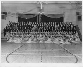
North Burnaby High School graduating class
https://search.heritageburnaby.ca/link/museumdescription13404
- Repository
- Burnaby Village Museum
- Date
- 1959
- Collection/Fonds
- Burnaby Village Museum Photograph collection
- Description Level
- Item
- Physical Description
- 1 photograph : b&w ; 20 x 25.5 cm
- Scope and Content
- Photograph of graduates of Burnaby North High School. A large group of over one hundred and fifty students are dressed in formal attire and posed inside a gymnasium during the graduation ceremony and dinner. The women appear to be wearing prom dresses while the men are dressed in suits. David Morga…
- Repository
- Burnaby Village Museum
- Collection/Fonds
- Burnaby Village Museum Photograph collection
- Description Level
- Item
- Physical Description
- 1 photograph : b&w ; 20 x 25.5 cm
- Scope and Content
- Photograph of graduates of Burnaby North High School. A large group of over one hundred and fifty students are dressed in formal attire and posed inside a gymnasium during the graduation ceremony and dinner. The women appear to be wearing prom dresses while the men are dressed in suits. David Morgan is identified standing in the fifth row from the bottom, fifth from the left.
- History
- In 1922 the Burnaby North High School opened at its first permanent location (4375 Pandora Street - which is now Rosser Elementary). In 1945, the Willingdon Avenue site was built and was used until a new building was constructed in 1961 on Hammarskjold Drive. From 1962, the school was used as Burnaby Heights Junior High school, but it closed in 1982 and the junior high students went to the new Burnaby North on Hammarskjold.
- Accession Code
- BV020.8.1
- Access Restriction
- No restrictions
- Reproduction Restriction
- May be restricted by third party rights
- Date
- 1959
- Media Type
- Photograph
- Scan Resolution
- 600
- Scan Date
- August 11, 2020
- Scale
- 100
- Notes
- Title based on contents of item
Images

Ramsey family subseries
https://search.heritageburnaby.ca/link/archivedescription106
- Repository
- City of Burnaby Archives
- Date
- 1916 (date of original) -1999
- Collection/Fonds
- Burnaby Historical Society fonds
- Description Level
- Subseries
- Physical Description
- Textual record and graphic material
- Scope and Content
- Subseries consists of a photocopied certificate of birth for Eva Lilian Ramsey [Ramsay] as well as handwritten accounts of Ramsey family history and two family photographs.
- Repository
- City of Burnaby Archives
- Date
- 1916 (date of original) -1999
- Collection/Fonds
- Burnaby Historical Society fonds
- Subseries
- Ramsey family subseries
- Physical Description
- Textual record and graphic material
- Description Level
- Subseries
- Accession Number
- BHS1999-19
- Scope and Content
- Subseries consists of a photocopied certificate of birth for Eva Lilian Ramsey [Ramsay] as well as handwritten accounts of Ramsey family history and two family photographs.
- History
- Edwin Ramsey came to Canada from Scotland when he was about 11 years old. He was given farmland and quickly became an avid farmer. Edwin Ramsey married Annie Plummer circa 1893. This was Annie Plummer’s second marriage. In the early years of their marriage, Edwin and Annie lived in Orange Ridge, Manitoba and operated a store and post office. Their first child, Queenie, was born November 11, 1895. Albert Edwin "Bert" Ramsey was born January 27, 1898. Eva Lilian Ramsey was born January 24, 1900. Jessica “Jessie” Ramsey was born two years later. The Ramseys then headed to New Westminster. By 1905 they had bought "the Park” (what is now Robert Burnaby Park) from Mr. Wintermute for $4,000 cash. They moved into a large house already constructed on the property. The park was full of apple trees, a garden, pigs, two cows, horses and a buggy and wagon with a barn near the second street entrance. By now, the eldest, Queenie was enrolled at Burnaby’s first school. Twins Ernest “Ernie” and Dorothy “Doll” were born in 1906. Eva started at Edmonds School in 1908 when it was just built. Her siblings Queenie, Bert, Jeanie, Ernie and Doll all attended the school as well. In 1909 the Ramseys sold the park to Mr. Vidal of New Westminster and his syndicate along with a portable mill to Pemberton & Sons and received enough money to buy six lots on 12th Avenue where they built a large house. Gordon “Gord” Ramsey was born in that house in 1909. Soon after, they sold the house and moved to Blaine for six months, then on to Bellingham where they remained until Edwin and Annie divorced in 1914. Edwin moved alone to Alberta and Annie moved back to Burnaby with their children. Bert began attending the University of British Columbia where he studied to become a doctor. He joined the army in May of 1916, went to war and was killed at Vimy Ridge on April 12, 1917 at the age of 19. As Mr. Vital and his syndicate were to go to war as captains, Mr. Vital gave up the park property and Annie was able to take it back. Unfortunately, the new initiative of taxing wild lands caused Annie to lose the park property through tax sale proceedings. She then entered into a lease agreement with Burnaby which allowed her to stay on at "the Park." With twelve years of piano training, Annie was considered a talented musician and played the piano at St. Alban’s church for many years. Annie Ramsey died on October 3, 1926. Jessica, Dorothy and Queenie all moved to the United States. Gordon married a woman named Irene. Eva married William “Bill” Anderson at the St. Stephen’s Church in New Westminster on July 7, 1919. She and Bill were the first couple to marry there. They held their wedding reception at “the Park.” In 1921, Bill and Eva bought a home at 723 Second Street for $2450. They had one daughter, Dorothy "Dot" Anderson. Dot later married Robert V. “Bob” Douglas. Eva died in 1995.
- Media Type
- Textual Record
- Photograph
- Creator
- Ramsay, Eva Lillian
- Notes
- PC399 and MSS154
- Title based on contents of subseries
- Certificate reads "Ramsay" although the family continuously spelt their name "Ramsey"

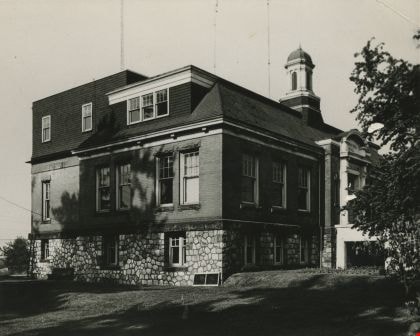
Second Municipal Hall at Kingsway and Edmonds
https://search.heritageburnaby.ca/link/archivedescription37286
- Repository
- City of Burnaby Archives
- Date
- 1958
- Collection/Fonds
- Burnaby Historical Society fonds
- Description Level
- Item
- Physical Description
- 1 photograph : b&w ; 10.1 x 12.7 cm
- Scope and Content
- Photograph of the old Municipal Hall building at Kingsway and Edmonds. This building was constructed in 1911 and used as the Municipal Hall until 1956, at which time the new Hall was built at the current location (4949 Canada Way).
- Repository
- City of Burnaby Archives
- Date
- 1958
- Collection/Fonds
- Burnaby Historical Society fonds
- Subseries
- Norah Code subseries
- Physical Description
- 1 photograph : b&w ; 10.1 x 12.7 cm
- Description Level
- Item
- Record No.
- 345-007
- Access Restriction
- No restrictions
- Reproduction Restriction
- Reproduce for fair dealing purposes only
- Accession Number
- BHS1997-05
- Scope and Content
- Photograph of the old Municipal Hall building at Kingsway and Edmonds. This building was constructed in 1911 and used as the Municipal Hall until 1956, at which time the new Hall was built at the current location (4949 Canada Way).
- Subjects
- Buildings - Civic - City Halls
- Names
- Burnaby City Hall
- Media Type
- Photograph
- Photographer
- Code, Norah
- Notes
- Title based on contents of photograph.
- Photographs in this collection were taken and compiled by Norah Code, former editor of the "Burnaby Courier" newspaper during the course of her work for the newspaper.
- Geographic Access
- Kingsway
- Street Address
- 7282 Kingsway
- Historic Neighbourhood
- Edmonds (Historic Neighbourhood)
- Planning Study Area
- Stride Avenue Area
Images