Narrow Results By
Subject
- Buildings - Commercial 1
- Buildings - Industrial - Mills 1
- Buildings - Industrial - Powerhouses 4
- Buildings - Residential - Houses 7
- Construction 7
- Construction - Railroad Construction 3
- Construction - Road Construction 2
- Construction Tools and Equipment 2
- Geographic Features - Cities 1
- Geographic Features - Creeks 1
- Occupations - Labourers 2
- Occupations - Railroad Labourers 2
![Barnet Mill being rebuilt, [1909] (date of original), copied [1998] thumbnail](/media/hpo/_Data/_Archives_Images/_Unrestricted/316/363-002.jpg?width=280)
Barnet Mill being rebuilt
https://search.heritageburnaby.ca/link/archivedescription37363
- Repository
- City of Burnaby Archives
- Date
- [1909] (date of original), copied [1998]
- Collection/Fonds
- Burnaby Historical Society fonds
- Description Level
- Item
- Physical Description
- 1 photograph : b&w ; 10 x 15 cm print
- Scope and Content
- Photograph of lumber piled up and the skeleton of a building being framed during the rebuilding of the Barnet Mill after the fire of 1909. The Barnet Mill was called the North Pacific Lumber Company from 1889 to 1914.
- Repository
- City of Burnaby Archives
- Date
- [1909] (date of original), copied [1998]
- Collection/Fonds
- Burnaby Historical Society fonds
- Subseries
- Jim Wolf subseries
- Physical Description
- 1 photograph : b&w ; 10 x 15 cm print
- Description Level
- Item
- Record No.
- 363-002
- Access Restriction
- No restrictions
- Reproduction Restriction
- No known restrictions
- Accession Number
- BHS1998-13
- Scope and Content
- Photograph of lumber piled up and the skeleton of a building being framed during the rebuilding of the Barnet Mill after the fire of 1909. The Barnet Mill was called the North Pacific Lumber Company from 1889 to 1914.
- Names
- Barnet Mill
- Media Type
- Photograph
- Notes
- Title based on contents of photograph
- Geographic Access
- Barnet Village
- Texaco Drive
- Street Address
- 8059 Texaco Drive
- Historic Neighbourhood
- Barnet (Historic Neighbourhood)
- Planning Study Area
- Burnaby Mountain Area
Images
![Barnet Mill being rebuilt, [1909] (date of original), copied [1998] thumbnail](/media/hpo/_Data/_Archives_Images/_Unrestricted/316/363-002.jpg)
![Brick Houses under Construction, [between 1899 and 1910] thumbnail](/media/hpo/_Data/_Archives_Images/_Unrestricted/513/514-002.jpg?width=280)
Brick Houses under Construction
https://search.heritageburnaby.ca/link/archivedescription64653
- Repository
- City of Burnaby Archives
- Date
- [between 1899 and 1910]
- Collection/Fonds
- Ernest Winch fonds
- Description Level
- Item
- Physical Description
- 1 photograph : b&w cabinet card ; 10 x 14.5 cm, mounted on card 10.5 x 16.5 cm
- Scope and Content
- Photograph of two brick houses under construction on High Street at Epping, Essex, England. These buildings were constructed by Ernest E. Winch.
- Repository
- City of Burnaby Archives
- Date
- [between 1899 and 1910]
- Collection/Fonds
- Ernest Winch fonds
- Physical Description
- 1 photograph : b&w cabinet card ; 10 x 14.5 cm, mounted on card 10.5 x 16.5 cm
- Description Level
- Item
- Record No.
- 514-002
- Access Restriction
- No restrictions
- Reproduction Restriction
- No known restrictions
- Accession Number
- 2010-06
- Scope and Content
- Photograph of two brick houses under construction on High Street at Epping, Essex, England. These buildings were constructed by Ernest E. Winch.
- Media Type
- Photograph
- Photographer
- Challoner-Courtenay, E.J.
- Notes
- Title based on contents of photograph
Images
![Brick Houses under Construction, [between 1899 and 1910] thumbnail](/media/hpo/_Data/_Archives_Images/_Unrestricted/513/514-002.jpg)
![Brick Houses under Construction, [between 1899 and 1910] thumbnail](/media/hpo/_Data/_Archives_Images/_Unrestricted/513/514-003.jpg?width=280)
Brick Houses under Construction
https://search.heritageburnaby.ca/link/archivedescription64654
- Repository
- City of Burnaby Archives
- Date
- [between 1899 and 1910]
- Collection/Fonds
- Ernest Winch fonds
- Description Level
- Item
- Physical Description
- 1 photograph : b&w cabinet card ; 10 x 14.5 cm, mounted on card 10.5 x 16.5 cm
- Scope and Content
- Photograph of two brick houses under construction on High Street at Epping, Essex, England. These buildings were constructed by Ernest E. Winch.
- Repository
- City of Burnaby Archives
- Date
- [between 1899 and 1910]
- Collection/Fonds
- Ernest Winch fonds
- Physical Description
- 1 photograph : b&w cabinet card ; 10 x 14.5 cm, mounted on card 10.5 x 16.5 cm
- Description Level
- Item
- Record No.
- 514-003
- Access Restriction
- No restrictions
- Reproduction Restriction
- No known restrictions
- Accession Number
- 2010-06
- Scope and Content
- Photograph of two brick houses under construction on High Street at Epping, Essex, England. These buildings were constructed by Ernest E. Winch.
- Subjects
- Construction
- Buildings - Residential - Houses
- Construction Tools and Equipment
- Occupations - Labourers
- Media Type
- Photograph
- Photographer
- Challoner-Courtenay, E.J.
- Notes
- Title based on contents of photograph
Images
![Brick Houses under Construction, [between 1899 and 1910] thumbnail](/media/hpo/_Data/_Archives_Images/_Unrestricted/513/514-003.jpg)
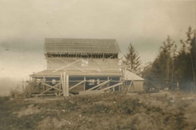
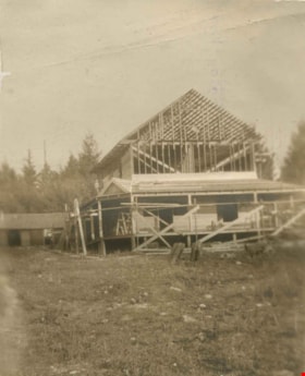
Broadview under construction
https://search.heritageburnaby.ca/link/archivedescription39555
- Repository
- City of Burnaby Archives
- Date
- 1907
- Collection/Fonds
- Peers Family and Hill Family fonds
- Description Level
- Item
- Physical Description
- 1 photograph : b&w ; 5.3 x 7.8 cm on page 21.5 x 28 cm (pasted in album)
- Scope and Content
- Photograph of the building of Broadview, the home belonging to Claude Hill on Buckingham Avenue. Shown here under construction, Broadview was finished around 1907 and was the second home for the Hill family in the Burnaby Lake area. The first, Brookfield, was on Deer Lake Avenue.
- Repository
- City of Burnaby Archives
- Date
- 1907
- Collection/Fonds
- Peers Family and Hill Family fonds
- Physical Description
- 1 photograph : b&w ; 5.3 x 7.8 cm on page 21.5 x 28 cm (pasted in album)
- Description Level
- Item
- Record No.
- 477-874
- Access Restriction
- No restrictions
- Reproduction Restriction
- No known restrictions
- Accession Number
- 2007-12
- Scope and Content
- Photograph of the building of Broadview, the home belonging to Claude Hill on Buckingham Avenue. Shown here under construction, Broadview was finished around 1907 and was the second home for the Hill family in the Burnaby Lake area. The first, Brookfield, was on Deer Lake Avenue.
- Media Type
- Photograph
- Notes
- Title based on contents of photograph
- Geographic Access
- Buckingham Avenue
- Street Address
- 5730 Buckingham Avenue
- Historic Neighbourhood
- Burnaby Lake (Historic Neighbourhood)
- Planning Study Area
- Morley-Buckingham Area
Images
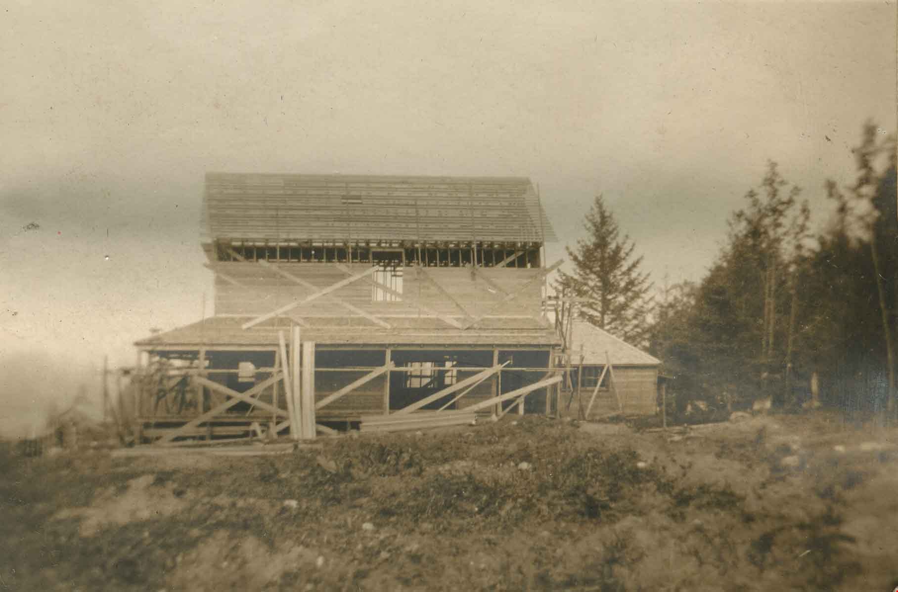
Building Broadview
https://search.heritageburnaby.ca/link/archivedescription39554
- Repository
- City of Burnaby Archives
- Date
- 1907
- Collection/Fonds
- Peers Family and Hill Family fonds
- Description Level
- Item
- Physical Description
- 1 photograph : b&w ; 5.2 x 6.3 cm on page 21.5 x 28 cm (pasted in album)
- Scope and Content
- Photograph of the building of Broadview, the home belonging to Claude Hill on Buckingham Avenue. Shown here under construction, Broadview was finished around 1907 and was the second home for the Hill family in the Burnaby Lake area. The first, Brookfield, was on Deer Lake Avenue.
- Repository
- City of Burnaby Archives
- Date
- 1907
- Collection/Fonds
- Peers Family and Hill Family fonds
- Physical Description
- 1 photograph : b&w ; 5.2 x 6.3 cm on page 21.5 x 28 cm (pasted in album)
- Description Level
- Item
- Record No.
- 477-873
- Access Restriction
- No restrictions
- Reproduction Restriction
- No known restrictions
- Accession Number
- 2007-12
- Scope and Content
- Photograph of the building of Broadview, the home belonging to Claude Hill on Buckingham Avenue. Shown here under construction, Broadview was finished around 1907 and was the second home for the Hill family in the Burnaby Lake area. The first, Brookfield, was on Deer Lake Avenue.
- Media Type
- Photograph
- Notes
- Title based on contents of photograph
- Geographic Access
- Buckingham Avenue
- Street Address
- 5730 Buckingham Avenue
- Historic Neighbourhood
- Burnaby Lake (Historic Neighbourhood)
- Planning Study Area
- Morley-Buckingham Area
Images

![Burnaby Substation, [September 1907] thumbnail](/media/hpo/_Data/_Archives_Images/_Unrestricted/251/293-002.jpg?width=280)
Burnaby Substation
https://search.heritageburnaby.ca/link/archivedescription36541
- Repository
- City of Burnaby Archives
- Date
- [September 1907]
- Collection/Fonds
- Burnaby Historical Society fonds
- Description Level
- Item
- Physical Description
- 1 photograph : b&w postcard ; 7.5 x 13 cm
- Scope and Content
- Photographic postcard of the British Columbia Electric Railway Company's Burnaby Substation that was built in 1903 and put into operation to receive and distribute power from the B.C.E.R. Buntzen Lake power dam. The electric lines came across the inlet at Barnet, along the Barnet-Hastings Road to S…
- Repository
- City of Burnaby Archives
- Date
- [September 1907]
- Collection/Fonds
- Burnaby Historical Society fonds
- Subseries
- John DeForest subseries
- Physical Description
- 1 photograph : b&w postcard ; 7.5 x 13 cm
- Description Level
- Item
- Record No.
- 293-002
- Access Restriction
- No restrictions
- Reproduction Restriction
- No known restrictions
- Accession Number
- BHS1992-30
- Scope and Content
- Photographic postcard of the British Columbia Electric Railway Company's Burnaby Substation that was built in 1903 and put into operation to receive and distribute power from the B.C.E.R. Buntzen Lake power dam. The electric lines came across the inlet at Barnet, along the Barnet-Hastings Road to Sperling Avenue (built for this project and called Pole Line Road) and then south to this site at the corner of Griffiths and the old Central Park interurban line (later this section was called the Highland Park line). This substation was constructed to convert the alternating current being delivered from the Buntzen power plant to direct current for the operation of the tram cars operating on the Central Park interurban route. The new brick substation replaced the wood fed steam powered 1891 Powerhouse that operated south of this site, across the tracks until its closure on May 31,1905. It was demolised in the late 1920s. This brick substation originally known as the Burnaby Substation, eventually became known as the Newell Substation. The original brick building was replaced by a new structure in 1930, which was demolished in the 1960s in favour of the open field substation that continues to operate on the same site today at 7260 Griffiths Avenue.
- Subjects
- Buildings - Industrial - Powerhouses
- Media Type
- Photograph
- Notes
- Title based on contents of photograph
- Geographic Access
- Griffiths Avenue
- Historic Neighbourhood
- Edmonds (Historic Neighbourhood)
- Planning Study Area
- Stride Avenue Area
Images
![Burnaby Substation, [September 1907] thumbnail](/media/hpo/_Data/_Archives_Images/_Unrestricted/251/293-002.jpg)
Buxton family fonds
https://search.heritageburnaby.ca/link/archivedescription64596
- Repository
- City of Burnaby Archives
- Date
- [1905-1915]
- Collection/Fonds
- Buxton Family fonds
- Description Level
- Fonds
- Physical Description
- 16 photographs (jpeg) : b&w and sepia
- Scope and Content
- Fonds consists of photographs of George Buxton and the construction of the Buxton family home in Burnaby, as well as photographs of Leopold Buxton and other members of the Buxton family.
- Repository
- City of Burnaby Archives
- Date
- [1905-1915]
- Collection/Fonds
- Buxton Family fonds
- Physical Description
- 16 photographs (jpeg) : b&w and sepia
- Description Level
- Fonds
- Record No.
- 41960
- Access Restriction
- No restrictions
- Reproduction Restriction
- May be restricted by third-party rights
- Accession Number
- 2010-05
- Scope and Content
- Fonds consists of photographs of George Buxton and the construction of the Buxton family home in Burnaby, as well as photographs of Leopold Buxton and other members of the Buxton family.
- History
- George Searby Buxton (1867-1955) was born in England and was a carpenter by trade. He married Mary Isabel Nattriss (1866-1941), a teacher, and moved to Canada in 1911. In 1912, George built an arts and crafts style home in Burnaby which remains as one of the City's heritage buildings to this day. George and Mary had five children: Clara Violet (1910-1913), Mary (1900-?), Alice Clarissa (Clissie) (1902-?), Bernard (1897-1972) and Leopold (1893-1951).
- Media Type
- Photograph
- Other Title Information
- Title was changed from Buxton family collection to Buxton family fonds to better reflect the nature of the materials.
- Notes
- Photo catalogue 513
![Clearing Douglas Road, [190-?] (date of original), copied 1977 thumbnail](/media/hpo/_Data/_BVM_Images/1977/1977_0099_0002_001.jpg?width=280)
Clearing Douglas Road
https://search.heritageburnaby.ca/link/museumdescription560
- Repository
- Burnaby Village Museum
- Date
- [190-?] (date of original), copied 1977
- Collection/Fonds
- Burnaby Village Museum Photograph collection
- Description Level
- Item
- Physical Description
- 1 photograph : b&w ; 20.2 x 25.2 cm print
- Scope and Content
- Photograph of men in work clothes clearing Doulgas Road. A group of men to the right side of the photograph have shovels in their hands and are clearing rocks from the road. There is a small girl in a blouse and skirt standing beside two horses pulling a cart. Behind her is a group of men in wor…
- Repository
- Burnaby Village Museum
- Collection/Fonds
- Burnaby Village Museum Photograph collection
- Description Level
- Item
- Physical Description
- 1 photograph : b&w ; 20.2 x 25.2 cm print
- Scope and Content
- Photograph of men in work clothes clearing Doulgas Road. A group of men to the right side of the photograph have shovels in their hands and are clearing rocks from the road. There is a small girl in a blouse and skirt standing beside two horses pulling a cart. Behind her is a group of men in work clothes as well. There is fenced land to the right of the photograph, and electric power poles and trees line both sides of the road. The accession register and inscription on the photograph identify this as Douglas Road (later renamed in part Canada Way). An annotation on the back of the photo reads: "Working on Douglas Road on hill above Burnaby Lake. No Date."
- Geographic Access
- Douglas Road
- Canada Way
- Accession Code
- HV977.99.2
- Access Restriction
- No restrictions
- Reproduction Restriction
- May be restricted by third party rights
- Date
- [190-?] (date of original), copied 1977
- Media Type
- Photograph
- Historic Neighbourhood
- Burnaby Lake (Historic Neighbourhood)
- Scan Resolution
- 600
- Scan Date
- 2023-07-11
- Notes
- Title based on contents of photograph
Images
![Clearing Douglas Road, [190-?] (date of original), copied 1977 thumbnail](/media/hpo/_Data/_BVM_Images/1977/1977_0099_0002_001.jpg)
Esther Love Stanley fonds
https://search.heritageburnaby.ca/link/museumdescription18841
- Repository
- Burnaby Village Museum
- Date
- 1896-[2015] (dates of originals)
- Collection/Fonds
- Esther Love Stanley fonds
- Description Level
- Fonds
- Physical Description
- 2 photograph albums + 3 photographs + 128 photographs (tiffs & jpgs) + 1 cm textual records
- Scope and Content
- Fonds consists of original photograph albums created by Esther (Love) Stanley as well as a collection of digital reproductions of photographs, documents and newspaper clippings pertaining to the Love, Stanley and Shankie families.
- Repository
- Burnaby Village Museum
- Collection/Fonds
- Esther Love Stanley fonds
- Description Level
- Fonds
- Physical Description
- 2 photograph albums + 3 photographs + 128 photographs (tiffs & jpgs) + 1 cm textual records
- Scope and Content
- Fonds consists of original photograph albums created by Esther (Love) Stanley as well as a collection of digital reproductions of photographs, documents and newspaper clippings pertaining to the Love, Stanley and Shankie families.
- History
- Esther Love Stanley was born in Burnaby in 1896 to parents Jesse Love (1847-1928) and Martha Leonard (1858-1920). Esther's father, Jesse Love was born in Swindon, England and left England to work on a dairy farm in the Toronto area. While working on the farm in Toronto, Jesse met Martha Leonard and they married in 1879. While living in Toronto, Jesse and Martha had two children, George (1880-1974) and Annie Elizabeth (1881-1957). About one year after Annie was born, the Love family moved to North Dakota to grow wheat. While living there, they had two more children, Henry (1883-1956) and Edith Minnie (1885-1976). The family decided to move further west after hearing about the fairer weather conditions from Martha’s father, George Leonard, who had settled in Vancouver in 1885. On May 23, 1887, Jesse, Martha and their four children arrived in Vancouver after travelling across Canada from Winnipeg on the first transcontinental train. Soon after their fifth child, Thomas Robert (1887-1918) was born, the family moved to Lulu Island in Richmond where they lived growing vegetables and selling them to Vancouver hotels. While living and farming on Lulu island, the couple had two more children Martha (Dot or Dorothy) (1889-1972) and Sarah Marie (1892-1978). In October 1893, Jesse Love purchased land in District Lot 25, Burnaby and built a house between 1893 and 1894. A road was constructed and named Cumberland in 1905 and the address for the Love home was 1390 Cumberland Road (after 1960- 7651 Cumberland). While living in the house, Jesse and Martha had four more children, Phoebe Leonard (1894-1991), Esther (1896-1991), John Leonard (1899-1978) and Hannah Victoria (also known as Girlie) (1902-1976). Frank Charles “Stan” Stanley was born in London, England in 1891. Frank “Stan” Stanley is the youngest son of John Stanley and Mary (Conquest) Stanley. John and Mary had eleven children: Conquest John “Con”, George, Alice, Mary, Nelly, Mabel Annie, Percy William, Henry James, Ada Elizabeth, Arthur Ewart and Frank Charles. In 1912, Frank Charles Stanley immigrated to Canada. Frank Stanley served in the 29th Battalion (nicknamed Tobin's Tigers) during the First World War. He received a Military Medal for bravery while serving as lieutenant. Esther Love and Frank “Stan” Stanley maintained a relationship through letter writing during the First World War and in 1921 after he returned, they were married at St. Alban’s Church in Burnaby. Frank and Esther Stanley (nee Love) had four children, Mary Frances (Pearson) (d. 1986), Ina Esther (Shankie) (1924-2017), Frank Conquest and Joyce (Warner). Frank Charles “Stan” Stanley ran a service station on St. John's Street in Port Moody for many years and also served as mayor of Port Moody in the 1940s. Frank Charles Stanley died in 1975 and Esther Love Stanley died in 1991. In 1947, Ina Esther Stanley married Thomas Ramsay “Ram” Shankie (1920-1996). Ina and Thomas Ramsay Shankie had four children; David Andre Shankie (b. 1951), Linda Lorraine Shankie (Hanlon), Susan Lesley Shankie (Weston) and Kathryn Louise Shankie. The family lived at 5351 Kalyk Avenue in Burnaby (later 3676 Kalyk Avenue). Thomas Ramsay Shankie is the son of Thomas Shankie (1872-1959) and Bertha Janet Shankie (nee Gray) (1891-1965). Thomas Shankie (Sr.) immigrated to Canada from Scotland in 1905. In 1919 Thomas Shankie married Bertha Janet Gray at Henderson Presbyterian Church in West Burnaby. Thomas was the church organist and choir master of the church. Once married, the couple moved to a house located at 3718 Barker Avenue (later became 5515 Barker Avenue). Thomas and Bertha Shankie had two children, Thomas Ramsay Shankie (1920-1996) and Janet Isabella Shankie (Bower) (1923-2014). Around the age of 46 years, Thomas Shankie joined a gym and bought a bicycle to improve his health. By 1955 at the age of 83 years, Thomas Shankie had logged over two hundred thousand miles since buying his first bicycle. His motto was "ride a bicycle if you want to stay young and live long". Thomas also competed in many cycling races. Janet Isabella Shankie Bower (1923-2014) married Charles Franklin "Frank" Bower (1914-2004) in 1947. Janet and Frank Bower had two children; Gordon Franklin Bower (1951-2003) and Janet (Flintroy).
- Creator
- Stanley, Esther Love
- Accession Code
- BV015.40
- BV016.43
- BV022.32
- Access Restriction
- No restrictions
- Reproduction Restriction
- No known restrictions
- Date
- 1896-[2015] (dates of originals)
- Media Type
- Photograph
- Arrangement
- Creator as well as descendants maintained original photograph albums along with digital copies of original family records. A selection of digital copies and originals were preserved in the order in which they were maintained and are reflected in the archival descriptions. When original photograph albums were acquired in 2022, some digital surrogates were deaccesioned.
- Notes
- Title based on contents of fonds
- See also Love family fonds
- Items of ephemera are described as artifacts in the Burnaby Village Museum artifact collection.
E.W. Bateman family fonds
https://search.heritageburnaby.ca/link/museumdescription15157
- Repository
- Burnaby Village Museum
- Date
- [1857]-[195-]
- Collection/Fonds
- E.W. Bateman family fonds
- Description Level
- Fonds
- Physical Description
- 63 photographs + 6 cm of textual records
- Scope and Content
- Fonds consists of photographs of the family of Edwin Wettenhall Bateman and residences including Elworth house, along with letters written by Colin Rhodes Fox during World War II. Fonds is arranged into the following series: 1) Bateman family photographs series 2) Bateman family World War II lette…
- Repository
- Burnaby Village Museum
- Collection/Fonds
- E.W. Bateman family fonds
- Description Level
- Fonds
- Physical Description
- 63 photographs + 6 cm of textual records
- Scope and Content
- Fonds consists of photographs of the family of Edwin Wettenhall Bateman and residences including Elworth house, along with letters written by Colin Rhodes Fox during World War II. Fonds is arranged into the following series: 1) Bateman family photographs series 2) Bateman family World War II letters series
- History
- Edwin Wettenhall "E.W." Bateman was born in 1859 in Sandbach, Cheshire, to James and Caroline Mary Wettenhall Bateman (their home in Sandbach was called Elworth Cottage). When he was twenty-one, E.W. Bateman immigrated to Manitoba, Canada where he met Catherine “Cassie” Dale, daughter of George and Sarah Gillon Dale. They were married in Portage La Prairie, Manitoba on November 9, 1886. Edwin and Cassie had seven children, the eldest Edna Caroline Annie (Corner) (1889-1969); George Edwin (1890-? ); Mamie (McWilliams) (1892-1979); Marianne “May” Bateman (1894-1990); Warren Stafford (1896-1954); Jessie (Fox Kemp) (1899-1978) and John Carey (1901-1945). Catherine “Cassie” (Dale) Bateman died in Portage La Prairie in 1909. After Cassie's death, Edwin was transferred to Vancouver by the Canadian Pacific Railway where he married Cassie’s younger sister Mary Dale (1896-1935). Edwin moved his six of his seven children to Vancouver (not including George). Edwin and Mary (Dale) Bateman first lived at 7th and Balsam Street in Vancouver and in 1920, they decided to move to the quieter atmosphere of the Burnaby Lake- Deer Lake area. By this time Edwin Wettenhall Bateman was a retired CPR executive. He moved his wife and daughter Marianne “May” Bateman to Deer Lake and commissioned architect, Enoch Evans to build 'Elworth' house (named after Edwin’s family home in Sandbach, Chesire). The house was completed by contractor William Dodson in 1922 and located at the site of what would become Heritage Village and later, Burnaby Village Museum, 6501 Deer Lake Avenue. The Batemans lived at this location for thirteen years before moving back to Vancouver in May of 1935. Mary Dale Bateman died in July 1935 and sometime after, Edwin W. Bateman married Dora Coulton. Edwin W. Bateman died in 1957 at the age of 98. Edna Caroline Bateman married Raymond Westley Corner in 1920 and had a daughter named Catherine Mary (Levins). Edna and Raymond lived in Kelowna. George Bateman married Louise Agness Birss in January 1910 and continued to live in Manitoba. Mamie Dale Bateman married George Lloyd McWilliams in 1915. The couple had two children, Warren Finley McWilliams and Bruce McWilliams. Mamie and George McWilliams lived with their family on Douglas Road across the road from Elworth house in Burnaby. Warren McWilliams was on North Atlantic convoy duty during World War I from 1942 to 1944. Warren McWilliams died in 2004. Warren Stafford Bateman married Norah Withington in Burnaby in 1924; Winifred Dare Webster in Burnaby in 1932 and Dorothy Margaret Buchanan in New Westminster in 1949. Warren and Winnifred “Winnie” Webster celebrated their marriage at Elworth house in 1932. Warren served in World War I. Jessie Madeline Bateman married Ernest Denby Fox (1900-1945) in 1921. Jessie and Ernest Fox had three children, Colin Rhodes Fox (1921-2005); Mary “Betty” (Gludo) and Allan Fox. Jessie and Ernest Fox operated a small logging company near Powell River, B.C. Sometime after the death of her first husband, Ernest Denby Fox, Jessie married James Kemp. The youngest child of Edwin and Cassie, John “Carey” Bateman married Sophia Spak (1899-1977) in 1925. On September 10, 1939, the day that Canada declared war on Germany, Colin Rhodes Fox (eldest son of Jessie and Ernest Fox) enlisted in the army at the age of 18 years. Colin initially served in an anti-aircraft unit, but was soon transferred to the Field Artillery. During his service overseas, Colin wrote letters to family members including his aunt May Bateman who was living in Burnaby. Colin went through basic artillery training in Edmonton before heading overseas to the United Kingdom with his unit, the 13th Field Regiment , 44th Canadian Field Battery of the Royal Canadian Artillery and later the 78th Canadian Field Battery in Germany and Holland . Colin was wounded on June 8, 1944 (two days after D-Day) but returned to serve in Holland and Germany until the war ended. Colin suffered bullet and shrapnel wounds while laying communication cable from the Normandy beachhead. In 1946, Colin married Susan Streika (Striha) of Pitt Meadows and he began a thirty five year career in the B.C. Telephone Company on Vancouver Island. Colin and Susan had three children; Gary, Elaine and Irene. Colin Rhodes Fox died in 2005. The E.W. Bateman house, "Elworth" is a heritage building on the site of the Burnaby Village Museum. The site is an important cultural feature for the interpretation of Burnaby’s heritage to the public. The E.W. Bateman House was purchased by Burnaby in 1970 and became the focal point for the development of the Museum. Both the interior and exterior of the house have been restored and interpreted to the date of original construction, including recreated room interiors and period furnishings.
- Accession Code
- HV974.22
- HV974.90
- HV975.120
- HV976.37
- HV979.32
- BV985.1003
- BV986.21
- BV992.29
- BV994.22
- BV004.28
- BV004.84
- BV020.27
- Date
- [1857]-[195-]
- Media Type
- Photograph
- Textual Record
- Related Material
- See also: Interview with Marianne May Bateman February 22, 1978 - Tracks 1-4. City of Burnaby Archives Item No. MSS137-014-1
- Notes
- Title based on contents of fonds
![Family in front of their house, [190-] thumbnail](/media/hpo/_Data/_BVM_Images/1983/1983_0042_0069_001.jpg?width=280)
Family in front of their house
https://search.heritageburnaby.ca/link/museumdescription329
- Repository
- Burnaby Village Museum
- Date
- [190-]
- Collection/Fonds
- Burnaby Village Museum Photograph collection
- Description Level
- Item
- Physical Description
- 1 photograph : b&w ; 8.3 x 5.8 cm
- Scope and Content
- Photograph of an unidentified family of three, a woman, a man and a girl, standing in front of a large two storey house with an attic and large porch around the front entrance. The house appears to be under construction or just finished being constructed. There are pipes and possibly a ditch in f…
- Repository
- Burnaby Village Museum
- Collection/Fonds
- Burnaby Village Museum Photograph collection
- Description Level
- Item
- Physical Description
- 1 photograph : b&w ; 8.3 x 5.8 cm
- Material Details
- inscribed in black ink, verso, c. "Pa looks as if/ he had a wooden/ leg.", l.r. " "ha ha" "
- Scope and Content
- Photograph of an unidentified family of three, a woman, a man and a girl, standing in front of a large two storey house with an attic and large porch around the front entrance. The house appears to be under construction or just finished being constructed. There are pipes and possibly a ditch in front of the house. The location is not identified. An annotation on the back of the photo reads: "Pa looks as if He had a wooden leg. / 'ha, ha'."
- Subjects
- Buildings - Residential - Houses
- Accession Code
- HV983.42.69
- Access Restriction
- No restrictions
- Reproduction Restriction
- No known restrictions
- Date
- [190-]
- Media Type
- Photograph
- Scan Resolution
- 600
- Scan Date
- 2023-09-26
- Notes
- Title based on contents of photograph
Images
![Family in front of their house, [190-] thumbnail](/media/hpo/_Data/_BVM_Images/1983/1983_0042_0069_001.jpg)
![Forth Bridge, [1900-1930] thumbnail](/media/hpo/_Data/_Archives_Images/_Unrestricted/550/550-143.jpg?width=280)
Forth Bridge
https://search.heritageburnaby.ca/link/archivedescription82572
- Repository
- City of Burnaby Archives
- Date
- [1900-1930]
- Collection/Fonds
- Hill family and Vidal family fonds
- Description Level
- Item
- Physical Description
- 1 photograph : col. postcard ; 9 x 14 cm
- Scope and Content
- Photographic postcard shows Forth Bridge in Scotland.
- Repository
- City of Burnaby Archives
- Date
- [1900-1930]
- Collection/Fonds
- Hill family and Vidal family fonds
- Physical Description
- 1 photograph : col. postcard ; 9 x 14 cm
- Description Level
- Item
- Record No.
- 550-143
- Access Restriction
- No restrictions
- Reproduction Restriction
- No known restrictions
- Accession Number
- 2013-03
- Scope and Content
- Photographic postcard shows Forth Bridge in Scotland.
- Subjects
- Structures - Bridges
- Media Type
- Photograph
- Notes
- Title based on contents of photograph
- Postcard verso reads: "The Forth Bridge from South Queens Ferry. One of the greatest engineering glories of the age; was constructed by Sir William Arrol. Is about 1 1/2 miles in length, and its highest point is 450 feet from base. It took seven years to build (1883-1890) and cost 3 1/2 million pounds. It is on the main railway route of the L and N E Railway / New Color-crayon / Process from original drawing by Andrew Allan"
Images
![Forth Bridge, [1900-1930] thumbnail](/media/hpo/_Data/_Archives_Images/_Unrestricted/550/550-143.jpg)
![Granville Street looking south from Rogers building, [between 1908 and 1911] thumbnail](/media/hpo/_Data/_BVM_Images/1972/1972_0050_0002_002.jpg?width=280)
Granville Street looking south from Rogers building
https://search.heritageburnaby.ca/link/museumdescription1063
- Repository
- Burnaby Village Museum
- Date
- [between 1908 and 1911]
- Collection/Fonds
- Burnaby Village Museum Photograph collection
- Description Level
- Item
- Physical Description
- 1 photograph : b&w ; 6.1 x 10.7 cm mounted on paper 13.5 x 18.3 cm
- Scope and Content
- Photograph of Granville Street in Vancouver, looking south from the Roger's Building. The two tall buildings to the sides are under construction, and steam is blowing out from building chimneys. Busy street activities can be seen below with two trams running along the tracks.Inscribed on the scrapb…
- Repository
- Burnaby Village Museum
- Collection/Fonds
- Burnaby Village Museum Photograph collection
- Description Level
- Item
- Physical Description
- 1 photograph : b&w ; 6.1 x 10.7 cm mounted on paper 13.5 x 18.3 cm
- Scope and Content
- Photograph of Granville Street in Vancouver, looking south from the Roger's Building. The two tall buildings to the sides are under construction, and steam is blowing out from building chimneys. Busy street activities can be seen below with two trams running along the tracks.Inscribed on the scrapbook paper in white ink: "Granville Street / Looking South / From Rogers Building / Vancouver B.C."
- Geographic Access
- Vancouver
- Accession Code
- HV972.50.2
- Access Restriction
- No restrictions
- Reproduction Restriction
- No known restrictions
- Date
- [between 1908 and 1911]
- Media Type
- Photograph
- Scan Resolution
- 600
- Scan Date
- 2023-03-28
- Photographer
- Dean, H.M.
- Notes
- Title based on caption of photograph
Images
![Granville Street looking south from Rogers building, [between 1908 and 1911] thumbnail](/media/hpo/_Data/_BVM_Images/1972/1972_0050_0002_002.jpg)
![Great Northern Railroad, [1903] thumbnail](/media/hpo/_Data/_Archives_Images/_Unrestricted/477/477-837.jpg?width=280)
Great Northern Railroad
https://search.heritageburnaby.ca/link/archivedescription39518
- Repository
- City of Burnaby Archives
- Date
- [1903]
- Collection/Fonds
- Peers Family and Hill Family fonds
- Description Level
- Item
- Physical Description
- 1 photograph : sepia ; 5 x 5 cm on page 21.5 x 28 cm (pasted in album)
- Scope and Content
- Photograph of men working on the Great Northern Railroad line that ran through the Burnaby Lake area by 1904.
- Repository
- City of Burnaby Archives
- Date
- [1903]
- Collection/Fonds
- Peers Family and Hill Family fonds
- Physical Description
- 1 photograph : sepia ; 5 x 5 cm on page 21.5 x 28 cm (pasted in album)
- Description Level
- Item
- Record No.
- 477-837
- Access Restriction
- No restrictions
- Reproduction Restriction
- No known restrictions
- Accession Number
- 2007-12
- Scope and Content
- Photograph of men working on the Great Northern Railroad line that ran through the Burnaby Lake area by 1904.
- Names
- Great Northern Railway
- Media Type
- Photograph
- Notes
- Title based on contents of photograph
- Historic Neighbourhood
- Burnaby Lake (Historic Neighbourhood)
Images
![Great Northern Railroad, [1903] thumbnail](/media/hpo/_Data/_Archives_Images/_Unrestricted/477/477-837.jpg)
Great Northern Railway
https://search.heritageburnaby.ca/link/archivedescription35887
- Repository
- City of Burnaby Archives
- Date
- 1903 (date of original), copied 1986
- Collection/Fonds
- Burnaby Historical Society fonds
- Description Level
- Item
- Physical Description
- 1 photograph : b&w ; 12.7 x 17.8 cm print
- Scope and Content
- Photograph of the building of the Great Northern railway along Burnaby Lake.
- Repository
- City of Burnaby Archives
- Date
- 1903 (date of original), copied 1986
- Collection/Fonds
- Burnaby Historical Society fonds
- Subseries
- Pioneer Tales subseries
- Physical Description
- 1 photograph : b&w ; 12.7 x 17.8 cm print
- Description Level
- Item
- Record No.
- 204-746
- Access Restriction
- No restrictions
- Reproduction Restriction
- No known restrictions
- Accession Number
- BHS1988-03
- Scope and Content
- Photograph of the building of the Great Northern railway along Burnaby Lake.
- Names
- Great Northern Railway
- Media Type
- Photograph
- Notes
- Title based on contents of photograph
- Annotation at top of photograph reads, "Deer 1903"
- Planning Study Area
- Burnaby Lake Area
Images
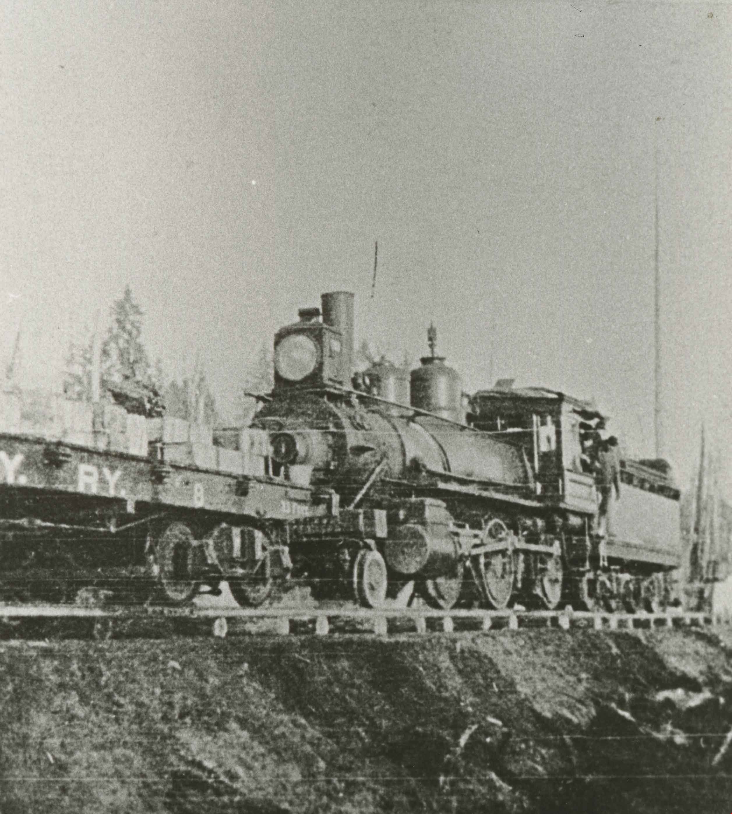
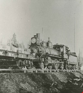
![Great Northern Railway construction, [1904] thumbnail](/media/hpo/_Data/_Archives_Images/_Unrestricted/477/477-168.jpg?width=280)
Great Northern Railway construction
https://search.heritageburnaby.ca/link/archivedescription38849
- Repository
- City of Burnaby Archives
- Date
- [1904]
- Collection/Fonds
- Peers Family and Hill Family fonds
- Description Level
- Item
- Physical Description
- 1 photograph : b&w ; 5.5 x 5.5 cm
- Scope and Content
- Photograph of a work crew working on the Great Northern Railway line that ran along the north shore of Burnaby Lake. The line was built ca. 1904.
- Repository
- City of Burnaby Archives
- Date
- [1904]
- Collection/Fonds
- Peers Family and Hill Family fonds
- Physical Description
- 1 photograph : b&w ; 5.5 x 5.5 cm
- Description Level
- Item
- Record No.
- 477-168
- Access Restriction
- No restrictions
- Reproduction Restriction
- No known restrictions
- Accession Number
- 2007-12
- Scope and Content
- Photograph of a work crew working on the Great Northern Railway line that ran along the north shore of Burnaby Lake. The line was built ca. 1904.
- Subjects
- Occupations - Railroad Labourers
- Construction - Railroad Construction
- Transportation - Rail
- Names
- Great Northern Railway
- Media Type
- Photograph
- Notes
- Title based on contents of photograph
- Historic Neighbourhood
- Burnaby Lake (Historic Neighbourhood)
Images
![Great Northern Railway construction, [1904] thumbnail](/media/hpo/_Data/_Archives_Images/_Unrestricted/477/477-168.jpg)
![Historic photo of Cariboo Road, [190-] date of original, copied [198_] thumbnail](/media/hpo/_Data/_BVM_Images/2020/2020_0005_0860_001.jpg?width=280)
Historic photo of Cariboo Road
https://search.heritageburnaby.ca/link/museumdescription13516
- Repository
- Burnaby Village Museum
- Date
- [190-] date of original, copied [198_]
- Collection/Fonds
- Century Park Museum Association fonds
- Description Level
- Item
- Physical Description
- 1 photograph : b&w print ; 8.7 x 12.5 cm
- Scope and Content
- Photograph of a historic photograph of an unidentified man standing on a boardwalk on the corner of Cariboo Road in Burnaby. Historic photograph includes a label in the top corner that reads: "Cariboo Rd / Burnaby". The road is made of dirt and a two story house is visible across the road from the …
- Repository
- Burnaby Village Museum
- Collection/Fonds
- Century Park Museum Association fonds
- Description Level
- Item
- Physical Description
- 1 photograph : b&w print ; 8.7 x 12.5 cm
- Scope and Content
- Photograph of a historic photograph of an unidentified man standing on a boardwalk on the corner of Cariboo Road in Burnaby. Historic photograph includes a label in the top corner that reads: "Cariboo Rd / Burnaby". The road is made of dirt and a two story house is visible across the road from the man.
- Subjects
- Construction - Road Construction
- Names
- Burnaby Village Museum
- Geographic Access
- Cariboo Road
- Accession Code
- BV020.5.860
- Access Restriction
- No restrictions
- Reproduction Restriction
- May be restricted by third party rights
- Date
- [190-] date of original, copied [198_]
- Media Type
- Photograph
- Scan Resolution
- 600
- Scan Date
- 25-Aug-2020
- Scale
- 100
- Photographer
- Brown, Cice Chandler
- Notes
- Title based on contents of photograph
Images
![Historic photo of Cariboo Road, [190-] date of original, copied [198_] thumbnail](/media/hpo/_Data/_BVM_Images/2020/2020_0005_0860_001.jpg)
![Intake of Burnaby's water supply, [190-?] (date of original), copied 1977 thumbnail](/media/hpo/_Data/_BVM_Images/1977/1977_0099_0025_001.jpg?width=280)
Intake of Burnaby's water supply
https://search.heritageburnaby.ca/link/museumdescription583
- Repository
- Burnaby Village Museum
- Date
- [190-?] (date of original), copied 1977
- Collection/Fonds
- Burnaby Village Museum Photograph collection
- Description Level
- Item
- Physical Description
- 1 photograph : b&w ; 20.2 x 25.2 cm print
- Scope and Content
- Photograph of a building by fast flowing stream. There are dense forests to both sides of the photograph, and mountains in the distance. Three men in suits and ties are standing by the house. The catalogue record identifies the photograph as "intake of Burnaby's water supply," and also notes "Bruce…
- Repository
- Burnaby Village Museum
- Collection/Fonds
- Burnaby Village Museum Photograph collection
- Description Level
- Item
- Physical Description
- 1 photograph : b&w ; 20.2 x 25.2 cm print
- Scope and Content
- Photograph of a building by fast flowing stream. There are dense forests to both sides of the photograph, and mountains in the distance. Three men in suits and ties are standing by the house. The catalogue record identifies the photograph as "intake of Burnaby's water supply," and also notes "Bruce Patterson took this picture."
- Accession Code
- HV977.99.25
- Access Restriction
- No restrictions
- Reproduction Restriction
- May be restricted by third party rights
- Date
- [190-?] (date of original), copied 1977
- Media Type
- Photograph
- Scan Resolution
- 600
- Scan Date
- 2023-07-18
- Photographer
- Patterson, Bruce
- Notes
- Title based on catalogue record
Images
![Intake of Burnaby's water supply, [190-?] (date of original), copied 1977 thumbnail](/media/hpo/_Data/_BVM_Images/1977/1977_0099_0025_001.jpg)
![Interior of the Burnaby Substation, [September 1908] thumbnail](/media/hpo/_Data/_Archives_Images/_Unrestricted/251/293-003.jpg?width=280)
Interior of the Burnaby Substation
https://search.heritageburnaby.ca/link/archivedescription36542
- Repository
- City of Burnaby Archives
- Date
- [September 1908]
- Collection/Fonds
- Burnaby Historical Society fonds
- Description Level
- Item
- Physical Description
- 1 photograph : b&w postcard ; 7.5 x 13 cm
- Scope and Content
- Photographic postcard of the interior of the British Columbia Electric Railway Company's Burnaby Substation that was built in 1903 and put into operation to receive and distribute power from the B.C.E.R. Buntzen Lake power dam. The electric lines came across the inlet at Barnet, along the Barnet-Ha…
- Repository
- City of Burnaby Archives
- Date
- [September 1908]
- Collection/Fonds
- Burnaby Historical Society fonds
- Subseries
- John DeForest subseries
- Physical Description
- 1 photograph : b&w postcard ; 7.5 x 13 cm
- Description Level
- Item
- Record No.
- 293-003
- Access Restriction
- No restrictions
- Reproduction Restriction
- No known restrictions
- Accession Number
- BHS1992-30
- Scope and Content
- Photographic postcard of the interior of the British Columbia Electric Railway Company's Burnaby Substation that was built in 1903 and put into operation to receive and distribute power from the B.C.E.R. Buntzen Lake power dam. The electric lines came across the inlet at Barnet, along the Barnet-Hastings Road to Sperling Avenue (built for this project and called Pole Line Road) and then south to this site at the corner of Griffiths and the old Central Park interurban line (later this section was called the Highland Park line). This substation was constructed to convert the alternating current being delivered from the Buntzen power plant to direct current for the operation of the tram cars operating on the Central Park interurban route. The new brick substation replaced the wood fed steam powered 1891 Powerhouse that operated south of this site, across the tracks until its closure on May 31,1905. It was demolised in the late 1920s. This brick substation originally known as the Burnaby Substation, eventually became known as the Newell Substation. The original brick building was replaced by a new structure in 1930, which was demolished in the 1960s in favour of the open field substation that continues to operate on the same site today at 7260 Griffiths Avenue.
- Subjects
- Buildings - Industrial - Powerhouses
- Media Type
- Photograph
- Notes
- Title based on contents of photograph
- Geographic Access
- Griffiths Avenue
- Historic Neighbourhood
- Edmonds (Historic Neighbourhood)
- Planning Study Area
- Stride Avenue Area
Images
![Interior of the Burnaby Substation, [September 1908] thumbnail](/media/hpo/_Data/_Archives_Images/_Unrestricted/251/293-003.jpg)
![Interior of the Burnaby Substation, [September 1908] thumbnail](/media/hpo/_Data/_Archives_Images/_Unrestricted/251/293-004.jpg?width=280)
Interior of the Burnaby Substation
https://search.heritageburnaby.ca/link/archivedescription36543
- Repository
- City of Burnaby Archives
- Date
- [September 1908]
- Collection/Fonds
- Burnaby Historical Society fonds
- Description Level
- Item
- Physical Description
- 1 photograph : b&w postcard ; 7.5 x 13 cm
- Scope and Content
- Photographic postcard of the interior of the British Columbia Electric Railway Company's Burnaby Substation that was built in 1903 and put into operation to receive and distribute power from the B.C.E.R. Buntzen Lake power dam. The electric lines came across the inlet at Barnet, along the Barnet-Ha…
- Repository
- City of Burnaby Archives
- Date
- [September 1908]
- Collection/Fonds
- Burnaby Historical Society fonds
- Subseries
- John DeForest subseries
- Physical Description
- 1 photograph : b&w postcard ; 7.5 x 13 cm
- Description Level
- Item
- Record No.
- 293-004
- Access Restriction
- No restrictions
- Reproduction Restriction
- No known restrictions
- Accession Number
- BHS1992-30
- Scope and Content
- Photographic postcard of the interior of the British Columbia Electric Railway Company's Burnaby Substation that was built in 1903 and put into operation to receive and distribute power from the B.C.E.R. Buntzen Lake power dam. The electric lines came across the inlet at Barnet, along the Barnet-Hastings Road to Sperling Avenue (built for this project and called Pole Line Road) and then south to this site at the corner of Griffiths and the old Central Park interurban line (later this section was called the Highland Park line). This substation was constructed to convert the alternating current being delivered from the Buntzen power plant to direct current for the operation of the tram cars operating on the Central Park interurban route. The new brick substation replaced the wood fed steam powered 1891 Powerhouse that operated south of this site, across the tracks until its closure on May 31,1905. It was demolised in the late 1920s. This brick substation originally known as the Burnaby Substation, eventually became known as the Newell Substation. The original brick building was replaced by a new structure in 1930, which was demolished in the 1960s in favour of the open field substation that continues to operate on the same site today at 7260 Griffiths Avenue.
- Subjects
- Buildings - Industrial - Powerhouses
- Media Type
- Photograph
- Notes
- Title based on contents of photograph
- Geographic Access
- Griffiths Avenue
- Historic Neighbourhood
- Edmonds (Historic Neighbourhood)
- Planning Study Area
- Stride Avenue Area
Images
![Interior of the Burnaby Substation, [September 1908] thumbnail](/media/hpo/_Data/_Archives_Images/_Unrestricted/251/293-004.jpg)