75 years, 1926-2001, Royal Oak Community Church : committed to Christ & community
https://search.heritageburnaby.ca/link/museumlibrary5444
- Repository
- Burnaby Village Museum
- Collection
- Reference Collection
- Material Type
- Book
- Call Number
- 971 ROC
- Place of Publication
- [Burnaby, B.C.]
- Publisher
- Royal Oak Community Church
- Publication Date
- 2001
- Physical Description
- [7] p. : ill. ; 22 cm.
- Library Subject (LOC)
- Church anniversaries
- Church buildings
- Church history
- Notes
- Formerly, Alta Vista Baptist Chruch--p. [1].
![All Saints Church, [ca.1910] thumbnail](/media/hpo/_Data/_BVM_Cartographic_Material/2003/2003_0083_0046_001.jpg?width=280)
All Saints Church
https://search.heritageburnaby.ca/link/museumdescription11924
- Repository
- Burnaby Village Museum
- Date
- [ca.1910]
- Collection/Fonds
- Ronald G. Scobbie collection
- Description Level
- Item
- Physical Description
- 1 plan : black ink and watercol. on paper ; 30.45 x 30.5 cm
- Scope and Content
- Item consists of building insurance plan of "All Saints Church / Lot "A" BK 29 DL 98 GP1 N.W.D.". Watling Street is idenfied to the north of the church building and Royal Oak Avenue to the west.
- Repository
- Burnaby Village Museum
- Collection/Fonds
- Ronald G. Scobbie collection
- Description Level
- Item
- Physical Description
- 1 plan : black ink and watercol. on paper ; 30.45 x 30.5 cm
- Material Details
- Scale 1 inch = 20 feet
- Scope and Content
- Item consists of building insurance plan of "All Saints Church / Lot "A" BK 29 DL 98 GP1 N.W.D.". Watling Street is idenfied to the north of the church building and Royal Oak Avenue to the west.
- Subjects
- Buildings - Religious - Churches
- Accession Code
- BV003.83.46
- Access Restriction
- No restrictions
- Reproduction Restriction
- No known restrictions
- Date
- [ca.1910]
- Media Type
- Cartographic Material
- Scan Resolution
- 600
- Scan Date
- 15-Jan-2021
- Scale
- 100
- Notes
- Transcribed title
- Note in pencil on verso reads: ""All Saints Church / Lot "A" BK 29 DL 98 / Scale 1 inch = 20 feet"
- Note in balck in on verso reads: "3704"
Images
![All Saints Church, [ca.1910] thumbnail](/media/hpo/_Data/_BVM_Cartographic_Material/2003/2003_0083_0046_001.jpg)

Alta Vista Baptist Church
https://search.heritageburnaby.ca/link/landmark557
- Repository
- Burnaby Heritage Planning
- Description
- Church building.
- Associated Dates
- 1936
- Other Names
- Royal Oak Community Church
- Street View URL
- Google Maps Street View
- Repository
- Burnaby Heritage Planning
- Other Names
- Royal Oak Community Church
- Geographic Access
- Royal Oak Avenue
- Associated Dates
- 1936
- Description
- Church building.
- Heritage Value
- This Baptist congregation originally held services in a tent at the corner of McGregor Avenue and Portland but they soon were able to build a small church. A membership drive by Pastor Arthur James Bowbrick (1875-1961) was so successful that the congregation was able build this fine structure, prominently located at the corner of Victory Street. Although it has been altered with later additions and stucco over the original siding, the original windows and the rooftop belfry remain.
- Locality
- Alta Vista
- Historic Neighbourhood
- Alta Vista (Historic Neighbourhood)
- Planning Study Area
- Sussex-Nelson Area
- Ownership
- Private
- Street Address
- 7175 Royal Oak Avenue
- Street View URL
- Google Maps Street View
Images


Application for Permission to Erect a Sunday School and Church Building on Lots 5 and 6, Block 4, DL 68
https://search.heritageburnaby.ca/link/councilreport47922
- Repository
- City of Burnaby Archives
- Report ID
- 47869
- Meeting Date
- 29-Aug-1949
- Format
- Council - Mayor/Councillor/Staff Report
- Collection/Fonds
- City Council and Office of the City Clerk fonds
- Repository
- City of Burnaby Archives
- Report ID
- 47869
- Meeting Date
- 29-Aug-1949
- Format
- Council - Mayor/Councillor/Staff Report
- Collection/Fonds
- City Council and Office of the City Clerk fonds
Documents
![Burnaby family gravestones, [194-] thumbnail](/media/hpo/_Data/_BVM_Images/1976/1976_0065_0003_001.jpg?width=280)
Burnaby family gravestones
https://search.heritageburnaby.ca/link/museumdescription745
- Repository
- Burnaby Village Museum
- Date
- [194-]
- Collection/Fonds
- Burnaby Village Museum Photograph collection
- Description Level
- Item
- Physical Description
- 1 photograph : b&w ; 11.4 x 8.9 cm
- Scope and Content
- Photograph of the grave marker for Robert Burnaby and other family members in cemetery in Loughborough, United Kingdom. The grave marker is a cross on three tiered slabs with plaque on each. The top one reads, "Robert Burnaby / Born Nov. 30. 1828: Died Jan. 10.1878." The middle one reads, "Sarah…
- Repository
- Burnaby Village Museum
- Collection/Fonds
- Burnaby Village Museum Photograph collection
- Description Level
- Item
- Physical Description
- 1 photograph : b&w ; 11.4 x 8.9 cm
- Scope and Content
- Photograph of the grave marker for Robert Burnaby and other family members in cemetery in Loughborough, United Kingdom. The grave marker is a cross on three tiered slabs with plaque on each. The top one reads, "Robert Burnaby / Born Nov. 30. 1828: Died Jan. 10.1878." The middle one reads, "Sarah Burnaby / Born October 22. 1822: Died March 2 1875./ Rev. VII. 14." The bottom one reads, "Sarah, Widow of the / Rev. Thomas Burnaby, / And mother of the above. / Died: Oct. 31, 1878, Aged 80 Years." It is suspected that the grave marker was located in the large church building that is shown in photo HV976.65.1. There is a brick wall behind the grave marker. Stamped on the back of the photo: "4387."
- Subjects
- Monuments - Gravestones
- Accession Code
- HV976.65.3
- Access Restriction
- No restrictions
- Reproduction Restriction
- No known restrictions
- Date
- [194-]
- Media Type
- Photograph
- Related Material
- For a closer view of the grave marker, see HV976.65.2
- Scan Resolution
- 600
- Scan Date
- 2023-06-20
- Notes
- Title based on contents of photograph
- 1 b&w copy negative accompanying
Images
![Burnaby family gravestones, [194-] thumbnail](/media/hpo/_Data/_BVM_Images/1976/1976_0065_0003_001.jpg)
Burnaby's heritage : an inventory of buildings and structures
https://search.heritageburnaby.ca/link/museumlibrary5437
- Repository
- Burnaby Village Museum
- Author
- Luxton, Donald, 1954-
- Wolf, Jim
- Edition
- Rev.
- Publication Date
- 2011
- c2007
- Call Number
- 971.133 LUX COPY 1
- Repository
- Burnaby Village Museum
- Collection
- Digital Reference Collection
- Material Type
- Book
- ISBN
- 0969282893
- Call Number
- 971.133 LUX COPY 1
- Edition
- Rev.
- Author
- Luxton, Donald, 1954-
- Wolf, Jim
- Place of Publication
- Burnaby, B.C.
- Publisher
- City of Burnaby
- Publication Date
- 2011
- c2007
- Physical Description
- 157 p. : ill. ; 28 cm.
- Library Subject (LOC)
- Architecture
- Historic buildings
- Buildings
- Historic sites
- Subjects
- Buildings
- Buildings - Heritage
- Notes
- Includes bibliographical references and index.
- 2 copies held: copy 1.
Digital Books

Chapel Of Peace
https://search.heritageburnaby.ca/link/landmark566
- Repository
- Burnaby Heritage Planning
- Description
- Church building.
- Associated Dates
- 1936
- Formal Recognition
- Heritage Designation, Community Heritage Register
- Other Names
- First United Spiritualist Church
- Street View URL
- Google Maps Street View
- Repository
- Burnaby Heritage Planning
- Other Names
- First United Spiritualist Church
- Geographic Access
- Kincaid Street
- Associated Dates
- 1936
- Formal Recognition
- Heritage Designation, Community Heritage Register
- Enactment Type
- Bylaw No. 13162
- Enactment Date
- 28/01/2013
- Description
- Church building.
- Heritage Value
- This church was built in 1936 as the Chapel of Peace for the Forest Lawn Cemetery. It was located outside the main entrance of the cemetery at the triangular parcel of land bounded by Sprott, Royal Oak and Canada Way. It served as the location for many memorial services, local community worship and weddings. The Anglican Church purchased and relocated the building to its present site in 1955. The church has been altered with the addition of wings and stucco, but retains its steep front gabled roof and some of its arched windows. It is now used as the First United Spiritualist Church.
- Locality
- Burnaby Lake
- Historic Neighbourhood
- Burnaby Lake (Historic Neighbourhood)
- Planning Study Area
- Douglas-Gilpin Area
- Contributing Resource
- Building
- Ownership
- Private
- Street Address
- 5584 Kincaid Street
- Street View URL
- Google Maps Street View
Images


![Church, [194-] thumbnail](/media/hpo/_Data/_BVM_Images/1976/1976_0065_0001_001.jpg?width=280)
Church
https://search.heritageburnaby.ca/link/museumdescription743
- Repository
- Burnaby Village Museum
- Date
- [194-]
- Collection/Fonds
- Burnaby Village Museum Photograph collection
- Description Level
- Item
- Physical Description
- 1 photograph : b&w ; 8.9 x 11.3 cm
- Scope and Content
- Photograph of a large church building that has been conjectured in the accession register to be the church (or the cemetery) in which Robert Burnaby was buried. Following that logic, this would be in Loughborough, where Robert Burnaby is buried. Stamped on the back of the photo: "4387."
- Repository
- Burnaby Village Museum
- Collection/Fonds
- Burnaby Village Museum Photograph collection
- Description Level
- Item
- Physical Description
- 1 photograph : b&w ; 8.9 x 11.3 cm
- Scope and Content
- Photograph of a large church building that has been conjectured in the accession register to be the church (or the cemetery) in which Robert Burnaby was buried. Following that logic, this would be in Loughborough, where Robert Burnaby is buried. Stamped on the back of the photo: "4387."
- Subjects
- Buildings - Religious - Churches
- Accession Code
- HV976.65.1
- Access Restriction
- No restrictions
- Reproduction Restriction
- May be restricted by third party rights
- Date
- [194-]
- Media Type
- Photograph
- Scan Resolution
- 600
- Scan Date
- 2023-06-20
- Notes
- Title based on contents of photograph
- 1 b&w copy negative accompanying
Images
![Church, [194-] thumbnail](/media/hpo/_Data/_BVM_Images/1976/1976_0065_0001_001.jpg)
![Church building, [1910] thumbnail](/media/hpo/_Data/_BVM_Images/1973/1973_0110_0056_001.jpg?width=280)
Church building
https://search.heritageburnaby.ca/link/museumdescription1042
- Repository
- Burnaby Village Museum
- Date
- [1910]
- Collection/Fonds
- Burnaby Village Museum Photograph collection
- Description Level
- Item
- Physical Description
- 1 photograph : sepia
- Scope and Content
- Photograph of an unidentified church building. The inscription indicates that the building is in Los Gates, California.
- Repository
- Burnaby Village Museum
- Collection/Fonds
- Burnaby Village Museum Photograph collection
- Description Level
- Item
- Physical Description
- 1 photograph : sepia
- Material Details
- inscribed in pencil, verso, t. "Oha/ In Los Gates/ California"
- Scope and Content
- Photograph of an unidentified church building. The inscription indicates that the building is in Los Gates, California.
- Subjects
- Buildings - Religious - Churches
- Accession Code
- HV973.110.56
- Access Restriction
- No restrictions
- Reproduction Restriction
- No known restrictions
- Date
- [1910]
- Media Type
- Photograph
- Scan Resolution
- 600
- Scan Date
- 2023-05-30
- Notes
- Title based on contents of photograph
Images
![Church building, [1910] thumbnail](/media/hpo/_Data/_BVM_Images/1973/1973_0110_0056_001.jpg)
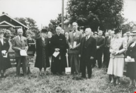
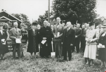
Dr. Laite and West Burnaby United Church Members
https://search.heritageburnaby.ca/link/archivedescription36753
- Repository
- City of Burnaby Archives
- Date
- 1948 (date of original), copied 1992
- Collection/Fonds
- Burnaby Historical Society fonds
- Description Level
- Item
- Physical Description
- 1 photograph : b&w ; 8.7 x 12.6 cm print
- Scope and Content
- Photograph of Dr. Laite and members of West Burnaby United Church, possibly on the occasion of the turning of the sod for a new church building.
- Repository
- City of Burnaby Archives
- Date
- 1948 (date of original), copied 1992
- Collection/Fonds
- Burnaby Historical Society fonds
- Subseries
- Burnaby Centennial Anthology subseries
- Physical Description
- 1 photograph : b&w ; 8.7 x 12.6 cm print
- Description Level
- Item
- Record No.
- 315-108
- Access Restriction
- No restrictions
- Reproduction Restriction
- No known restrictions
- Accession Number
- BHS1994-04
- Scope and Content
- Photograph of Dr. Laite and members of West Burnaby United Church, possibly on the occasion of the turning of the sod for a new church building.
- Media Type
- Photograph
- Notes
- Title based on contents of photograph
- Geographic Access
- Sussex Avenue
- Street Address
- 6050 Sussex Avenue
- Historic Neighbourhood
- Central Park (Historic Neighbourhood)
- Planning Study Area
- Marlborough Area
Images

Edmonds Baptist Church
https://search.heritageburnaby.ca/link/landmark575
- Repository
- Burnaby Heritage Planning
- Description
- Church building.
- Associated Dates
- 1912
- Street View URL
- Google Maps Street View
- Repository
- Burnaby Heritage Planning
- Geographic Access
- Walker Avenue
- Associated Dates
- 1912
- Description
- Church building.
- Heritage Value
- Beautifully designed in an Arts and Crafts idiom, this church features a textural mix of finishes including lapped siding and stucco and half timbering in the gables. The British Columbian reported in July 1912 that: "The Baptists of Edmonds will possess a fine and well planned church when the building now commenced is ready for occupation. The architects are J.P. Matheson and Son, of Vancouver, and the contractors, Muttitt and Bell, of New Westminster. The entrance porch fronts Edmonds Road and the west side faces Vancouver Road. It will have a capacity for 272 sittings, spacious aisles and choir platform besides various rooms for Baptistery, vestry and robing apartments."
- Locality
- Edmonds
- Historic Neighbourhood
- Edmonds (Historic Neighbourhood)
- Planning Study Area
- Richmond Park Area
- Architect
- J.P. Matheson & Son
- Builder
- Muttitt and Bell
- Area
- 1471.58
- Contributing Resource
- Building
- Ownership
- Private
- Names
- Matheson, John
- Street Address
- 7135 Walker Avenue
- Street View URL
- Google Maps Street View
Images


![Edmonds Baptist Church Choir, [between 1940 and 1945] thumbnail](/media/Q:/51305%20BVM%20Collections/51305-05%20Acquisitions/_DigitalAssets/2005/2005_0035_0017_001.jpg?width=280)
Edmonds Baptist Church Choir
https://search.heritageburnaby.ca/link/museumdescription1930
- Repository
- Burnaby Village Museum
- Date
- [between 1940 and 1945]
- Collection/Fonds
- Burnaby Village Museum Photograph collection
- Description Level
- Item
- Physical Description
- 1 photograph : b&w ; 5.5 x 8 cm
- Scope and Content
- Photograph of the Edmonds Baptist Church Choir standing in three rows in front of the church building. A sign posted by the church door reads, "Edmonds Baptist Church/ SERVICES/ CHURCH SCHOOL 9:45 AM/ MORNING SERVICE 11AM/ EVENING SERVICE 7:30PM/ WORSHIP WITH US" The women are wearing matching robe…
- Repository
- Burnaby Village Museum
- Collection/Fonds
- Burnaby Village Museum Photograph collection
- Description Level
- Item
- Physical Description
- 1 photograph : b&w ; 5.5 x 8 cm
- Scope and Content
- Photograph of the Edmonds Baptist Church Choir standing in three rows in front of the church building. A sign posted by the church door reads, "Edmonds Baptist Church/ SERVICES/ CHURCH SCHOOL 9:45 AM/ MORNING SERVICE 11AM/ EVENING SERVICE 7:30PM/ WORSHIP WITH US" The women are wearing matching robes with collars and are holding their psalm books in their hands. The men are dressed in suits. Standing in the back row are; Jim Davies, Bille Haines, Mr. Smithson, Bill Bennett, Angus Haines, Ray Bell and Ernie Aldersley. Standing in the middle row are; Gwen Bennett (later Stewart), Thelma Mower (later Hueskin), Nora Palmer (later Coulter) and Olive Day (later Martin). Standing in the back row are; Orpha Scott (later Davies), Elenor Taylor, Mildred Bennett, Gertrude Mower, Jean Smithson and Peggy Urquhart (later Fredericks).
- Subjects
- Organizations - Choirs
- Names
- Edmonds Baptist Church
- Davies, Jim
- Haines, Bill
- Smithson, Mr.
- Bennett, Bill
- Haines, Angus
- Bell, Ray
- Aldersley, Ernie
- Stewart, Gwen Bennett
- Hueskin, Thelma Mower
- Coulter, Nora Palmer
- Martin, Olive Day
- Davies, Orpha Scott
- Taylor, Eleanor
- Bennett, Mildred
- Mower, Gertrude
- Smithson, Jean
- Frederick, Margaret "Peggy" Urquhart
- Accession Code
- BV005.35.17
- Access Restriction
- No restrictions
- Date
- [between 1940 and 1945]
- Media Type
- Photograph
- Historic Neighbourhood
- Edmonds (Historic Neighbourhood)
- Scan Resolution
- 600
- Scan Date
- 11-Jun-09
- Scale
- 100
- Notes
- Title based on contents of photograph
- Note in black ink on verso of photograph reads: "BACK ROW Jim Davies, Bille Haines, Mr. Smithson, Bill Bennett Angus Haines, Ray Bell, Ernie Aldersley / Middle Row Gwen Bennett (Mrs. Stewart), Thelma Mower (Mrs Hueskin) Nora Palmer (Mrs. Coulter), Olive Day (Mrs. Martin)/ FRONT ROW Orpha Scott (Mrs. J. Davies), Elenor Taylor Mildred Bennett, Gertrude Mower Jean Smithson, Peggy Urquhart (Mrs. Fredericks)"
Images
![Edmonds Baptist Church Choir, [between 1940 and 1945] thumbnail](/media/Q:/51305%20BVM%20Collections/51305-05%20Acquisitions/_DigitalAssets/2005/2005_0035_0017_001.jpg)

History of Burnaby and vicinity
https://search.heritageburnaby.ca/link/museumlibrary6890
- Repository
- Burnaby Village Museum
- Author
- Green, George, 1872-1955
- Publication Date
- 1947
- Call Number
- 971.133 GRE Copy 2 Ver. 1
- Repository
- Burnaby Village Museum
- Collection
- Digital Reference Collection
- Special Collection
- Material Type
- Book
- Accession Code
- BV017.17.1
- Call Number
- 971.133 GRE Copy 2 Ver. 1
- Author
- Green, George, 1872-1955
- Place of Publication
- [S.l.]
- Publisher
- [s.n.]
- Publication Date
- 1947
- Printer
- Shoemaker , McLean & Veitch
- Physical Description
- 233 p. : ill., maps, ports. ; 23 cm.
- Inscription
- "Presented To my valued fried Rev. D. W. Scott. a former neighbor at Capitol Hill with best wishes of the author George Green Victoria March 1 1947" [handwritten in black ink on page opposing front pastedown] "BMMM-WU SIGNED 1st ED 50.00" [handwritten in pencil on page opposing front pastedown]
- Library Subject (LOC)
- Burnaby (B.C.)--History
- Burnaby (B.C.)
- Biography
- Name Access
- Green, George
- Notes
- Autographed by author
- "By George Green, pioneer resident of Burnaby, and an ex-Councillor. Charter Member of the British Columbia Historical Association, Vancouver Branch, and an Executive Member."
- Copy 2 of 2
Images

Digital Books
![Horse drawn carriage driving by church at Heritage Village, [between 1974 and 1979] thumbnail](/media/hpo/_Data/_BVM_Images/2017/201700460004_001.jpg?width=280)
Horse drawn carriage driving by church at Heritage Village
https://search.heritageburnaby.ca/link/museumdescription4373
- Repository
- Burnaby Village Museum
- Date
- [between 1974 and 1979]
- Collection/Fonds
- Century Park Museum Association fonds
- Description Level
- Item
- Physical Description
- 1 photograph : colour ; 11.2 cm x 8.9 cm
- Scope and Content
- Photograph of a horse drawn carriage driving by the church building at the Heritage Village (now Burnaby Village Museum). The carriage has three passengers and a driver. There are several other individuals in the photograph who are on horseback. Everyone appears to be wearing period costumes.
- Repository
- Burnaby Village Museum
- Collection/Fonds
- Century Park Museum Association fonds
- Description Level
- Item
- Physical Description
- 1 photograph : colour ; 11.2 cm x 8.9 cm
- Scope and Content
- Photograph of a horse drawn carriage driving by the church building at the Heritage Village (now Burnaby Village Museum). The carriage has three passengers and a driver. There are several other individuals in the photograph who are on horseback. Everyone appears to be wearing period costumes.
- History
- Donor was a volunteer with the Burnaby Village Museum for years and was in attendance on the day the Heritage Village Museum opened.
- Names
- Burnaby Village Museum
- Geographic Access
- Deer Lake Drive
- Accession Code
- BV017.46.4
- Reproduction Restriction
- No known restrictions
- Date
- [between 1974 and 1979]
- Media Type
- Photograph
- Scan Resolution
- 600
- Scan Date
- 03-Apr-2018
- Notes
- Title based on contents of photograph
Images
![Horse drawn carriage driving by church at Heritage Village, [between 1974 and 1979] thumbnail](/media/hpo/_Data/_BVM_Images/2017/201700460004_001.jpg)

Inkwells to Internet: A History of Burnaby Schools
https://search.heritageburnaby.ca/link/museumlibrary7551
- Repository
- Burnaby Village Museum
- Collection
- Reference Collection
- Digital Reference Collection
- Material Type
- Book
- ISBN
- 978-0-9781979-2-6
- Call Number
- 371 CAR
- Place of Publication
- Burnaby
- Publisher
- City of Burnaby
- Publication Date
- 2020
- Physical Description
- vii, 35 p. : ill. ; 29 cm.
- Library Subject (LOC)
- Burnaby (B.C.)--History
- Schools--British Columbia--Burnaby
- Subjects
- Education
- Notes
- "Includes index"
- A history of the Burnaby school district and individual school buildings in Burnaby, BC, between 1893 and 2013.
- The “First Nations cemetery” described on page 109 in Mary Johnson’s recollections was originally written as “Indian” and may refer to the Khalsa Diwan Society’s Sikh cremations at the Vancouver Cemetery.
Images

Digital Books

Land being cleared for Saint Theresa's Roman Catholic Church
https://search.heritageburnaby.ca/link/museumdescription902
- Repository
- Burnaby Village Museum
- Date
- 1929
- Collection/Fonds
- Burnaby Village Museum Photograph collection
- Description Level
- Item
- Physical Description
- 1 photograph : b&w ; 6.7 x 11.4 cm
- Scope and Content
- Photograph of three unidentified men standing on Douglas Road (later renamed in part Canada Way) with Laurel Street in the background on the left and the site of Saint Theresa's Roman Catholic Church as a lot with blackened stumps. The church was located at the southeast corner of Canada Way and L…
- Repository
- Burnaby Village Museum
- Collection/Fonds
- Burnaby Village Museum Photograph collection
- Description Level
- Item
- Physical Description
- 1 photograph : b&w ; 6.7 x 11.4 cm
- Scope and Content
- Photograph of three unidentified men standing on Douglas Road (later renamed in part Canada Way) with Laurel Street in the background on the left and the site of Saint Theresa's Roman Catholic Church as a lot with blackened stumps. The church was located at the southeast corner of Canada Way and Laurel Street. According to an accompanying note located with the photograph, the first church building burned to the ground the night before it was to be blessed. Insurance for the church had been arranged for by Colonel Dorrell only hours before it was burned and even though signatures had not been affixed to the policy, the insurance company honoured the claim. The second building was smaller and had no basement. Father Trainer was the first priest. This church was torn down in 1974 and a new church building was erected across the road on Canada Way.
- Subjects
- Land Clearing
- Geographic Access
- Douglas Road
- Canada Way
- Laurel Street
- Accession Code
- HV975.105.1
- Access Restriction
- No restrictions
- Reproduction Restriction
- No known restrictions
- Date
- 1929
- Media Type
- Photograph
- Historic Neighbourhood
- Burnaby Lake (Historic Neighbourhood)
- Planning Study Area
- Douglas-Gilpin Area
- Scan Resolution
- 600
- Scan Date
- 2023-06-06
- Notes
- Title based on contents of photograph
- Information on the scope and content of the photograph is taken from an acquisition record from the time of the accession
Images

![Looking north across the Fraser River, [1890] thumbnail](/media/hpo/_Data/_Archives_Images/_Unrestricted/477/477-903.jpg?width=280)
Looking north across the Fraser River
https://search.heritageburnaby.ca/link/archivedescription39584
- Repository
- City of Burnaby Archives
- Date
- [1890]
- Collection/Fonds
- Peers Family and Hill Family fonds
- Description Level
- Item
- Physical Description
- 1 photograph : b&w ; 16.5 x 24 cm on page 21.5 x 28 cm (pasted in album)
- Scope and Content
- Photograph of New Westminster, taken from Surrey's Brownsville dock area on the south side of the Fraser River, with the span of the city's downtown and residential area in a panorama from the foot of 8th Street on the left as far east as Elliot Street on the extreme right. The peeled and chamfered…
- Repository
- City of Burnaby Archives
- Date
- [1890]
- Collection/Fonds
- Peers Family and Hill Family fonds
- Physical Description
- 1 photograph : b&w ; 16.5 x 24 cm on page 21.5 x 28 cm (pasted in album)
- Description Level
- Item
- Record No.
- 477-903
- Access Restriction
- No restrictions
- Reproduction Restriction
- No known restrictions
- Accession Number
- 2007-12
- Scope and Content
- Photograph of New Westminster, taken from Surrey's Brownsville dock area on the south side of the Fraser River, with the span of the city's downtown and residential area in a panorama from the foot of 8th Street on the left as far east as Elliot Street on the extreme right. The peeled and chamfered logs on the riverbank were transported by skid road and river and are typical of how Burnaby logs would have been stored prior to milling by the sawmill companies located in the city. The large white church building on the right is St. Peters Catholic Church built in 1886 at Blackwood and Columbia streets. Note that the large building at the center on the waterfront is the New Westminster City Market building (It has the central gable and arched opening). It was located on Front Street at Lytton Square and served as the primary place for Burnaby's market gardeners to sell their produce. To the right of the City Market is the city's original Chinatown located on the east end of Front Street.
- Media Type
- Photograph
- Notes
- Title based on caption accompanying photograph
Images
![Looking north across the Fraser River, [1890] thumbnail](/media/hpo/_Data/_Archives_Images/_Unrestricted/477/477-903.jpg)
![Moving St. Helen's Church, [1955-1956] thumbnail](/media/hpo/_Data/_Archives_Images/_Unrestricted/494/495-003.jpg?width=280)
Moving St. Helen's Church
https://search.heritageburnaby.ca/link/archivedescription58379
- Repository
- City of Burnaby Archives
- Date
- [1955-1956]
- Collection/Fonds
- Sheila Minni fonds
- Description Level
- Item
- Physical Description
- 1 photograph : sepia ; 4.5 x 7 cm
- Scope and Content
- Photograph of a truck moving the St. Helen's Church building. The Church was replaced in 1956 with a new building.
- Repository
- City of Burnaby Archives
- Date
- [1955-1956]
- Collection/Fonds
- Sheila Minni fonds
- Physical Description
- 1 photograph : sepia ; 4.5 x 7 cm
- Description Level
- Item
- Record No.
- 495-003
- Access Restriction
- No restrictions
- Reproduction Restriction
- No known restrictions
- Accession Number
- 2009-04
- Scope and Content
- Photograph of a truck moving the St. Helen's Church building. The Church was replaced in 1956 with a new building.
- Media Type
- Photograph
- Notes
- Title based on contents of photograph
- Geographic Access
- Triumph Street
- Street Address
- 3894 Triumph Street
- Historic Neighbourhood
- Vancouver Heights (Historic Neighbourhood)
- Planning Study Area
- Burnaby Heights Area
Images
![Moving St. Helen's Church, [1955-1956] thumbnail](/media/hpo/_Data/_Archives_Images/_Unrestricted/494/495-003.jpg)

Ocean View Burial Park - Chapel
https://search.heritageburnaby.ca/link/landmark628
- Repository
- Burnaby Heritage Planning
- Geographic Access
- Imperial Street
- Associated Dates
- 1936
- Description
- Church building.
- Heritage Value
- Subsequent work at Ocean View was designed by local architects Sharp & Thompson through the 1950s, including the stone-faced Garden Chapel, built in 1936 as a replica of a Norman church. Prominent stone gates also replaced the original gates at the corner entrance. George Sharp (1880-1974) and Charles Thompson (1878-1961) formed Vancouver’s longest surviving architectural firm in 1908. They were born, educated and articled in London, before arriving in Vancouver via different routes. In 1912, the firm won the competition for the new University of British Columbia.
- Locality
- Alta Vista
- Historic Neighbourhood
- Alta Vista (Historic Neighbourhood)
- Planning Study Area
- Suncrest Area
- Architect
- Sharp & Thompson
- Area
- 359280.00
- Contributing Resource
- Building
- Ownership
- Private
- Street Address
- 4000 Imperial Street
Images


Pioneer tales of Burnaby
https://search.heritageburnaby.ca/link/museumlibrary5860
- Repository
- Burnaby Village Museum
- Collection
- Digital Reference Collection
- Reference Collection
- Material Type
- Book
- ISBN
- 096928280x
- Call Number
- 971.133 SON COPY 4
- Contributor
- Sone, Michael
- Place of Publication
- Burnaby, B.C.
- Publisher
- Corporation of the District of Burnaby
- Publication Date
- c1987
- Physical Description
- 495 p. : ill. ; 31 cm.
- Inscription
- "TR687 - Bryburgh" / handprinted in pencil on frontend page
- Library Subject (LOC)
- Pioneers--British Columbia--Burnaby
- Frontier and pioneer life
- Biography
- Object History
- Early Burnaby as recalled by the settlers themselves who arrived from every corner of the world between 1888 and 1930, some witnessing incorporation of the district in 1892, all seeking a better life for themselves and especially for their children, all helping transform the wilderness into the modern municipality of today.
- Notes
- "Editor Michael Sone".
- Includes index.
- 4 copies held: copy 4
Images
